Displaying items by tag: NSAD

#Angling - Sean Kyne, Minister with Responsibility for the inland fisheries sector, has welcomed Inland Fisheries Ireland’s intention to take on five new ‘Fisheries Projects Animators’.
These new recruits will assist community organisations nationwide in realising ambitious angling projects and conservation initiatives for the coming year.
“I have secured the additional funding for IFI to enable this recruitment which will build IFI’s capacity to support the many excellent community-based organisations engaged with our inland fisheries and sea angling resource who are delivering projects under the National Strategy for Angling Development,” said Minister Kyne.
“This is a key deliverable under the development strategy to supplement the excellent work IFI are doing in administering the investment scheme by offering assistance to community project promoters. These new temporary posts will harness the potential already in the sector to deliver on development projects.”
The inland fisheries resource is worth €836 million to the Irish economy annually and supports upwards of 11,000 jobs, often in rural and peripheral communities.
Inland Fisheries Ireland says it wants to grow the angling sector’s socio-economic contribution by an additional €60 million annually, by ensuring that Ireland’s fish stocks and angling infrastructure are protected and enhanced into the future.
Last year, 50 angling development projects around Ireland were awarded with funding to the value of €500,000 in total under Inland Fisheries Ireland’s 2016 Capital Works Fund. The successful applicants for 2018’s funding will be announced next week.
Suzanne Campion, head of business development with Inland Fisheries Ireland, said of the project animators plan: “We are delighted the minister has approved the funding for these roles. They will be exciting but challenging positions, requiring experience and expertise across a range of criteria, and will be geographically located based on the demands of the numerous projects seeking assistance and input.
“We will be looking for enthusiastic and driven candidates for this dynamic team that will enable stakeholders to deliver on projects and build capacity across the recreational fisheries sector.”
New Angling Developments Launched In Roscommon & Leitrim
#Angling - Denis Naughten, Minister for Communications, Climate Action and Environment, has officially launched two new angling developments by Inland Fisheries Ireland (IFI) at Emlaghroyan in Roscommon and ‘The Mudflats’ at Carrick-on-Shannon in Co Leitrim.
A new match angling stretch has been provided at Emlaghroyan, on the River Suck in Roscommon, with upgraded car parking and drive-to-peg facilities.
This development involved upgrading existing roadways and the construction of new access roadway.
Ten new match angling pegs have been provided, with a capacity for further extension.
The Suck Valley Angling Hub were recently granted additional funds through the National Strategy for Angling Development (NSAD) to extend the match venue to further promote tourism angling and facilitate match competitions in the Roscommon/East Galway area.
Together with recently unveiled developments on the River Suck at Lough Acalla, the total investment in the River Suck project was €87,000.
In Leitrim, another major 2017 development project has been completed with an investment of €103,000, providing new facilities at ‘The Mudflats’ on the main River Shannon at Carrick-on-Shannon.
The new floating angling stand is accompanied by improved roadways and parking, upgraded toilet facilities and a new slipway.
This is another important match angling venue, used widely for international match angling events such as the World Pairs and the Carrick Angling Festival.
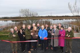
Speaking in Carrick-On-Shannon after the ribbon-cutting ceremony yesterday (Friday 1 December), Minister Naughten said: “I am delighted to mark the official opening of these developments today. Both were completed under the National Strategy for Angling Development (NSAD) and greatly enhance the angling infrastructure in both counties. They will provide a boost to angling tourism potential in the region, which in turn should increase visitor numbers.
“Furthermore, these projects would not be possible without the cooperation, agreement and vision of the respective landowners and I would like to thank all those involved for their contribution to these developments.”
More applications from the region are currently going through the NSAD assessment process, and aim to enhance the angling infrastructure in the upper Shannon areas as well as promote participation in angling.
Two weeks ago Minister Naughten unveiled new angling infrastructure in Galway and Athlone, as previously reported on Afloat.ie.
Public Consultation On National Strategy For Angling Development
#Angling - Minister for Natural Resources Joe McHugh has today (Monday 30 November) launched the public consultation on the National Strategy for Angling Development (NSAD).
Prepared by Inland Fisheries Ireland (IFI), the NSAD is the first comprehensive national framework for the development of Ireland's angling resource.
It is intended that the strategy will deliver a wide-ranging set of investments, innovations and promotions over the coming years.
This will ensure that Ireland's fish stocks and angling infrastructure are protected and enhanced for both their economic value and their recreational benefit to the communities and visitors they serve across the country.
“This strategy is necessary and timely to protect our wonderful inland fisheries and sea angling resources in their own right but also to safeguard and grow further the 11,350 jobs supported and €836 million contributed annually to Ireland’s economy by recreational angling," said Minister McHugh.
“These jobs and economic activity occur primarily in rural and peripheral areas of the country. The strategy supports the Government’s rural development, tourism and social inclusion objectives, and I urge all stakeholders to participate in the consultation process.”
IFI chief executive Dr Ciaran Byrne thanked all those who took part in the initial consultation process. “The inputs from stakeholders have been invaluable to Inland Fisheries Ireland in the preparation of the National Strategy for Angling Development. We look forward to working with all of our stakeholders in progressing the strategy.”
In accordance with Article 13(1)(b) of the European Communities (Environmental Assessment of Certain Plans and Programmes) Regulations 2004 (S.I. 435), as amended by the European Communities (Environmental Assessment of Certain Plans and Programmes)(Amendment) Regulations 2011, Inland Fisheries Ireland has prepared:
- A Strategic Environmental Assessment (SEA) Environmental Screening Report of the likely significant effects on the environment of implementing the Strategy, in accordance with Directive 2001/42/EC of the European Parliament and Council of 27 June 2001 on the assessment of the effects of certain plans and programmes on the environment as transposed into Irish law by the European Communities (Environmental Assessment of Certain Plans and Programmes) Regulations 2004 as amended.
- A Habitats Directive Screening Statement for Appropriate Assessment (AA), pursuant to Article 6 of Council Directive 92/43/EEC of 21 May 1992 on the conservation of natural habitats and of wild fauna and flora as transposed into Irish law by the European Communities (Birds and Natural Habitats) Regulations 2011.
The NSAD screening reports and supporting documents are available for viewing and downloading HERE; from IFI, 3044 Lake Drive, Citywest Business Campus, Dublin 24, D24 Y265; or at IFI offices countrywide (please see www.fisheriesireland.ie for addresses and maps).
Written submissions or observations should be sent to [email protected] or NSAD Consultation, 3044 Lake Drive, Citywest Business Campus, Dublin 24, D24 Y265 and must be received no later than Monday 4 January 2016.
For more information visit www.fisheriesireland.ie.


