Menu

Ireland's sailing, boating & maritime magazine

Dublin Bay Boating News and Information

Displaying items by tag: Not Ready

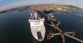
The UK's second biggest roll-on roll-off ferry port of Holyhead is from where Gwynedd Shipping operate and say they are "absolutely" not ready for a no deal Brexit.

Andrew Kinsella, Managing Director of the shipping company speaking on ITV News, (see: footage) says the infrastructure they need to avoid a backlog of lorries on the A55 is not in place and it is "implausible" that it will be in time.

Stena Line, the company who manage the port in Holyhead claim they "have taken all prudent steps" to prepare for a no deal Brexit.

Welsh Government have also said in the event of a no-deal, there are likely to be delays at customs but contingency plans are in place to minimise disruption.

Boris Johnson has indicated he wants a deal largely in place by October 11, the day the agenda is set for the European summit on October 18 when the Prime Minister is hoping EU leaders will sign off on an agreement.

Michael Gove, the minister in charge of no-deal Brexit preparations (yesterday) announced, "if the EU does not move this Government is prepared to leave without a deal on October 31."

For much more from the ITV News coverage click here. 

Published in Ferry

#ferries - On the UK south-east coast, the Port of Ramsgate "can not be ready" for extra ferry services in the event of a no-deal Brexit, according to the councillor for the harbour area.

Seaborne Freight according to BBC News, has been given a £13.8m contract to run a freight service between Ramsgate and Ostend in the event of a no-deal Brexit.

However, Conservative councillor Beverly Martin says the harbour can not be ready by Brexit on 29 March.

The government said facilities will be open "as soon as practicable".

In a statement the Department for Transport said that "works are underway".

Ramsgate has not had a regular ferry service since 2013.

Seaborne's contract as Afloat previously covered, was one of three awarded to ease "severe congestion" at Dover, in the case of a no-deal Brexit.

The contingency plans allow for almost 4,000 more lorries a week to come and go from other ports, including Plymouth, Poole, and Portsmouth.

In total the contracts are worth £103m.

"From local knowledge, there is terrific concern that we [Ramsgate Port] can not possibly by ready. There isn't the width or the breadth of the berths that is needed to carry large ships," the councillor said.

"I don't see how, with the state of the harbour and the port and the number of repairs that are needed that it could be ready."

For more including the contract to Seaborne, click here. 

Published in Ferry

Dublin Bay

Dublin Bay on the east coast of Ireland stretches over seven kilometres, from Howth Head on its northern tip to Dalkey Island in the south. It's a place most Dubliners simply take for granted, and one of the capital's least visited places. But there's more going on out there than you'd imagine.

The biggest boating centre is at Dun Laoghaire Harbour on the Bay's south shore that is home to over 1,500 pleasure craft, four waterfront yacht clubs and Ireland's largest marina.

The bay is rather shallow with many sandbanks and rocky outcrops, and was notorious in the past for shipwrecks, especially when the wind was from the east. Until modern times, many ships and their passengers were lost along the treacherous coastline from Howth to Dun Laoghaire, less than a kilometre from shore.

The Bay is a C-shaped inlet of the Irish Sea and is about 10 kilometres wide along its north-south base, and 7 km in length to its apex at the centre of the city of Dublin; stretching from Howth Head in the north to Dalkey Point in the south. North Bull Island is situated in the northwest part of the bay, where one of two major inshore sandbanks lie, and features a 5 km long sandy beach, Dollymount Strand, fronting an internationally recognised wildfowl reserve. Many of the rivers of Dublin reach the Irish Sea at Dublin Bay: the River Liffey, with the River Dodder flow received less than 1 km inland, River Tolka, and various smaller rivers and streams.

Dublin Bay FAQs

There are approximately ten beaches and bathing spots around Dublin Bay: Dollymount Strand; Forty Foot Bathing Place; Half Moon bathing spot; Merrion Strand; Bull Wall; Sandycove Beach; Sandymount Strand; Seapoint; Shelley Banks; Sutton, Burrow Beach

There are slipways on the north side of Dublin Bay at Clontarf, Sutton and on the southside at Dun Laoghaire Harbour, and in Dalkey at Coliemore and Bulloch Harbours.

Dublin Bay is administered by a number of Government Departments, three local authorities and several statutory agencies. Dublin Port Company is in charge of navigation on the Bay.

Dublin Bay is approximately 70 sq kilometres or 7,000 hectares. The Bay is about 10 kilometres wide along its north-south base, and seven km in length east-west to its peak at the centre of the city of Dublin; stretching from Howth Head in the north to Dalkey Point in the south.

Dun Laoghaire Harbour on the southside of the Bay has an East and West Pier, each one kilometre long; this is one of the largest human-made harbours in the world. There also piers or walls at the entrance to the River Liffey at Dublin city known as the Great North and South Walls. Other harbours on the Bay include Bulloch Harbour and Coliemore Harbours both at Dalkey.

There are two marinas on Dublin Bay. Ireland's largest marina with over 800 berths is on the southern shore at Dun Laoghaire Harbour. The other is at Poolbeg Yacht and Boat Club on the River Liffey close to Dublin City.

Car and passenger Ferries operate from Dublin Port to the UK, Isle of Man and France. A passenger ferry operates from Dun Laoghaire Harbour to Howth as well as providing tourist voyages around the bay.

Dublin Bay has two Islands. Bull Island at Clontarf and Dalkey Island on the southern shore of the Bay.

The River Liffey flows through Dublin city and into the Bay. Its tributaries include the River Dodder, the River Poddle and the River Camac.

Dollymount, Burrow and Seapoint beaches

Approximately 1,500 boats from small dinghies to motorboats to ocean-going yachts. The vast majority, over 1,000, are moored at Dun Laoghaire Harbour which is Ireland's boating capital.

In 1981, UNESCO recognised the importance of Dublin Bay by designating North Bull Island as a Biosphere because of its rare and internationally important habitats and species of wildlife. To support sustainable development, UNESCO’s concept of a Biosphere has evolved to include not just areas of ecological value but also the areas around them and the communities that live and work within these areas. There have since been additional international and national designations, covering much of Dublin Bay, to ensure the protection of its water quality and biodiversity. To fulfil these broader management aims for the ecosystem, the Biosphere was expanded in 2015. The Biosphere now covers Dublin Bay, reflecting its significant environmental, economic, cultural and tourism importance, and extends to over 300km² to include the bay, the shore and nearby residential areas.

On the Southside at Dun Laoghaire, there is the National Yacht Club, Royal St. George Yacht Club, Royal Irish Yacht Club and Dun Laoghaire Motor Yacht Club as well as Dublin Bay Sailing Club. In the city centre, there is Poolbeg Yacht and Boat Club. On the Northside of Dublin, there is Clontarf Yacht and Boat Club and Sutton Dinghy Club. While not on Dublin Bay, Howth Yacht Club is the major north Dublin Sailing centre.

© Afloat 2020