Menu

Ireland's sailing, boating & maritime magazine

Dublin Bay Boating News and Information

Displaying items by tag: Public Ownership

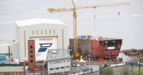
Shipyard Ferguson Marine has officially been taken into public ownership, the Scottish Government has announced.

The move, reports STV News, came on Tuesday after administrators agreed the final terms of the transaction with Scottish Ministers.

The yard will now be known as Ferguson Marine (Port Glasgow) Ltd.

There had been three other offers for the Inverclyde site, however administrators concluded the sale to the Scottish Government represented the best outcome for creditors.

Staff at the shipyard have been told of the latest position.

For more click here to read.

Published in Ports & Shipping

A contract has been signed by the Scottish Government to take the troubled Ferguson Marine shipyard into public ownership, reports The National.

It follows an agreement reached last month for the Government to take over the yard after the firm entered administration in August. A meeting of the board of directors of Macrocom – the company wholly owned by Scottish ministers that will own the Ferguson Marine business and assets – was held yesterday to consider and sign the contract.

Full completion of the contract and the final transaction is expected to take place in the coming weeks.

Finance Secretary Derek Mackay said the action taken would help to ensure a future for the yard. “Our focus has always been on ensuring completion of the two public sector ferries at the best value for money for the taxpayer, while also working towards the delivery of the other vessels under construction at the yard, and in doing so, securing jobs for the workforce,” he said.

More on the story here. 

Published in Ports & Shipping

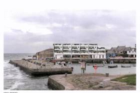
#BullochPublic - In a move being considered by Dun Laoghaire-Rathdown County Council, the local authority could bring land at Bulloch Harbour in Dalkey into public ownership.

The decision reports DublinLive, would also see the land developed in the public’s interest, was made at this month’s full meeting of the council.

A masterplan for the area cannot be considered by any planning authority unless it is submitted by the owners of the land being considered for development.

As a result, councillors have called on the council to consider taking ownership of the land.

In February, a residential and retail development proposed for Bulloch Harbour was refused permission, on the grounds that the development was “completely out of scale” with the harbour.
 
The move faced strong opposition from from local residents in Dalkey, along with singer Christy Moore and Solidarity/PBP TD Richard Boyd-Barrett.
 
This month's council meeting also sought to arrange a meeting between the Dun Laoighaire-Rathdown and the Dublin Port company, which it is hoped will allow for the discussion of a masterplan for the Sandycove and Bulloch Harbour areas.
Published in Coastal Notes

Dublin Bay

Dublin Bay on the east coast of Ireland stretches over seven kilometres, from Howth Head on its northern tip to Dalkey Island in the south. It's a place most Dubliners simply take for granted, and one of the capital's least visited places. But there's more going on out there than you'd imagine.

The biggest boating centre is at Dun Laoghaire Harbour on the Bay's south shore that is home to over 1,500 pleasure craft, four waterfront yacht clubs and Ireland's largest marina.

The bay is rather shallow with many sandbanks and rocky outcrops, and was notorious in the past for shipwrecks, especially when the wind was from the east. Until modern times, many ships and their passengers were lost along the treacherous coastline from Howth to Dun Laoghaire, less than a kilometre from shore.

The Bay is a C-shaped inlet of the Irish Sea and is about 10 kilometres wide along its north-south base, and 7 km in length to its apex at the centre of the city of Dublin; stretching from Howth Head in the north to Dalkey Point in the south. North Bull Island is situated in the northwest part of the bay, where one of two major inshore sandbanks lie, and features a 5 km long sandy beach, Dollymount Strand, fronting an internationally recognised wildfowl reserve. Many of the rivers of Dublin reach the Irish Sea at Dublin Bay: the River Liffey, with the River Dodder flow received less than 1 km inland, River Tolka, and various smaller rivers and streams.

Dublin Bay FAQs

There are approximately ten beaches and bathing spots around Dublin Bay: Dollymount Strand; Forty Foot Bathing Place; Half Moon bathing spot; Merrion Strand; Bull Wall; Sandycove Beach; Sandymount Strand; Seapoint; Shelley Banks; Sutton, Burrow Beach

There are slipways on the north side of Dublin Bay at Clontarf, Sutton and on the southside at Dun Laoghaire Harbour, and in Dalkey at Coliemore and Bulloch Harbours.

Dublin Bay is administered by a number of Government Departments, three local authorities and several statutory agencies. Dublin Port Company is in charge of navigation on the Bay.

Dublin Bay is approximately 70 sq kilometres or 7,000 hectares. The Bay is about 10 kilometres wide along its north-south base, and seven km in length east-west to its peak at the centre of the city of Dublin; stretching from Howth Head in the north to Dalkey Point in the south.

Dun Laoghaire Harbour on the southside of the Bay has an East and West Pier, each one kilometre long; this is one of the largest human-made harbours in the world. There also piers or walls at the entrance to the River Liffey at Dublin city known as the Great North and South Walls. Other harbours on the Bay include Bulloch Harbour and Coliemore Harbours both at Dalkey.

There are two marinas on Dublin Bay. Ireland's largest marina with over 800 berths is on the southern shore at Dun Laoghaire Harbour. The other is at Poolbeg Yacht and Boat Club on the River Liffey close to Dublin City.

Car and passenger Ferries operate from Dublin Port to the UK, Isle of Man and France. A passenger ferry operates from Dun Laoghaire Harbour to Howth as well as providing tourist voyages around the bay.

Dublin Bay has two Islands. Bull Island at Clontarf and Dalkey Island on the southern shore of the Bay.

The River Liffey flows through Dublin city and into the Bay. Its tributaries include the River Dodder, the River Poddle and the River Camac.

Dollymount, Burrow and Seapoint beaches

Approximately 1,500 boats from small dinghies to motorboats to ocean-going yachts. The vast majority, over 1,000, are moored at Dun Laoghaire Harbour which is Ireland's boating capital.

In 1981, UNESCO recognised the importance of Dublin Bay by designating North Bull Island as a Biosphere because of its rare and internationally important habitats and species of wildlife. To support sustainable development, UNESCO’s concept of a Biosphere has evolved to include not just areas of ecological value but also the areas around them and the communities that live and work within these areas. There have since been additional international and national designations, covering much of Dublin Bay, to ensure the protection of its water quality and biodiversity. To fulfil these broader management aims for the ecosystem, the Biosphere was expanded in 2015. The Biosphere now covers Dublin Bay, reflecting its significant environmental, economic, cultural and tourism importance, and extends to over 300km² to include the bay, the shore and nearby residential areas.

On the Southside at Dun Laoghaire, there is the National Yacht Club, Royal St. George Yacht Club, Royal Irish Yacht Club and Dun Laoghaire Motor Yacht Club as well as Dublin Bay Sailing Club. In the city centre, there is Poolbeg Yacht and Boat Club. On the Northside of Dublin, there is Clontarf Yacht and Boat Club and Sutton Dinghy Club. While not on Dublin Bay, Howth Yacht Club is the major north Dublin Sailing centre.

© Afloat 2020