Menu

Ireland's sailing, boating & maritime magazine

Dublin Bay Boating News and Information

Displaying items by tag: Rockabill

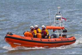
#RNLI - Skerries RNLI assisted a motor boat with two men aboard that was experiencing engine difficulties at Rockabill Lighthouse on Sunday afternoon (7 May).

Dublin Coast Guard tasked Skerries RNLI shortly after 12.30pm after receiving a call from a motor boat that was having difficulty getting their engine to start.

The lifeboat was launched with volunteer Philip Ferguson at the helm and crewed by Paddy Dillon, Steven Johnson and JP Tanner.

They proceeded on a course to Rockabill, and once on scene they located a 5m motor boat with two men on board that had become entangled in a lobster pot.

Following some troubleshooting advice from the lifeboat helm, a former RNLI mechanic, the men managed to successfully restart the engine. The lifeboat then stood by while they tested that everything was running smoothly.

With the men happy to be on their way again, the lifeboat returned to base and was made ready for the next call out.

Lifeboat press officer Gerry Canning said: “Sometimes, even though you are fully prepared you can just be unlucky. In this case their luck changed quickly as Philip used his experience to get them moving again. Our volunteers are always ready to help in whatever way they can.”

Published in RNLI Lifeboats

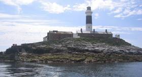
Saturday's 42–mile ISORA offshore race from Dun Laoghaire features Dublin lighthouses Rockabill and Kish and a finish back at Dun Laoghaire in time to join the apres–sail at Saturday's Royal St George Yacht Club Regatta. Download the race details below. 


Published in ISORA
Tagged under

#hyc – Howth Yacht Club will run an open double-handed race on Saturday, August 23, 2014 for both spinnaker cruiser classes and white sail cruiser classes. The course will use the Kish Lighthouse, Rockabill lighthouse and Lambay and will start and finish at Howth's East pier. The course will be approximately 40 miles with a start time of 10am and hopeful finish time of late afternoon.

Double handed sailing is the fastest growing fleet within the RORC race calendar and so this challenge will give a taste of shorthanded sailing to HYC crews and hopefully will attract visitors from other local clubs.

Preparation and participation in the HYC Double handed Challenge is a great way for competitors to build shorthanded sailing skills and have a safe fun passage.

So put this in your diary, pick a crew (just one) and go for a practice sail. Entry forms, Notice of Race and Sailing Instructions will be posted soon.

Published in Howth YC
Thirteen boats from an entry list of 24 came to the start line for the M2 Buoy day race, the tenth race in the 2011 ISORA Offshore series. Due to the forecast of light winds on the day it was decided to change the course and to go to Rockabill instead.
The course was from the start to round Rockabill to starboard and back to the finish at the mouth of Dun Laoghaire Harbour – 38 miles. The length of the original course to the M2 was 54 miles. To make the race more tactical, Ireland's Eye and Lambay were not marks on the course.
The start was provided by Larry Power of the NYC at the DBSC Pier mark. The wind at that time was south west and was gusting up to 25knots. This sent the fleet, most with spinnakers, charging towards the Bailey. It was not long before the wind decreased to 10-12 knots and veered to west.
"Tsunami" led the charge off the line but it was not long before "Lively Lady" took up poll position which she held for the remainder of the race. The fleet split as it approached Lambay. Those boats that chose to go inside the island went onto white sails while the boats that stayed outside could hold their spinnakers. There did not appear to be an advantage to either side of the island.
The fleet stayed well bunched at it approach Rockabill with "Lively Lady" rounding first followed by "English Mick" and "Jedi". On the return leg the wind decreased further to 8-10 knots from the west. Again the decision was whether to hold the spinnaker for the tight reach and what side of Lambay to go. "Lively Lady" who was leading the fleet again went inside while most of the fleet remained outside the island. This time however, there appeared to be an advantage as "Lively Lady" pulled further in front.
Passing Howth Head and approaching the finish, the wind got even more fickle. As the lead boats entered Dublin Bay the wind backed the south west giving abeat to the finish. However, there was no stopping "Lively Lady" who took line honours and first in Class 1 and Overall. "Tsunami" took 2nd place in Class 1 while "African Challenge" took 3rd in Class 1. "Jedi" took 1st place in Class 2 and 2nd Overall. "Adelie" took 1st in Class 3 and 3rd overall.
The finish was provided by Martin Lawless on the NYC.
The next race is on the 10th September, the "James Eadie Race" from Pwllheli to Howth.
Published in ISORA

Dublin Bay

Dublin Bay on the east coast of Ireland stretches over seven kilometres, from Howth Head on its northern tip to Dalkey Island in the south. It's a place most Dubliners simply take for granted, and one of the capital's least visited places. But there's more going on out there than you'd imagine.

The biggest boating centre is at Dun Laoghaire Harbour on the Bay's south shore that is home to over 1,500 pleasure craft, four waterfront yacht clubs and Ireland's largest marina.

The bay is rather shallow with many sandbanks and rocky outcrops, and was notorious in the past for shipwrecks, especially when the wind was from the east. Until modern times, many ships and their passengers were lost along the treacherous coastline from Howth to Dun Laoghaire, less than a kilometre from shore.

The Bay is a C-shaped inlet of the Irish Sea and is about 10 kilometres wide along its north-south base, and 7 km in length to its apex at the centre of the city of Dublin; stretching from Howth Head in the north to Dalkey Point in the south. North Bull Island is situated in the northwest part of the bay, where one of two major inshore sandbanks lie, and features a 5 km long sandy beach, Dollymount Strand, fronting an internationally recognised wildfowl reserve. Many of the rivers of Dublin reach the Irish Sea at Dublin Bay: the River Liffey, with the River Dodder flow received less than 1 km inland, River Tolka, and various smaller rivers and streams.

Dublin Bay FAQs

There are approximately ten beaches and bathing spots around Dublin Bay: Dollymount Strand; Forty Foot Bathing Place; Half Moon bathing spot; Merrion Strand; Bull Wall; Sandycove Beach; Sandymount Strand; Seapoint; Shelley Banks; Sutton, Burrow Beach

There are slipways on the north side of Dublin Bay at Clontarf, Sutton and on the southside at Dun Laoghaire Harbour, and in Dalkey at Coliemore and Bulloch Harbours.

Dublin Bay is administered by a number of Government Departments, three local authorities and several statutory agencies. Dublin Port Company is in charge of navigation on the Bay.

Dublin Bay is approximately 70 sq kilometres or 7,000 hectares. The Bay is about 10 kilometres wide along its north-south base, and seven km in length east-west to its peak at the centre of the city of Dublin; stretching from Howth Head in the north to Dalkey Point in the south.

Dun Laoghaire Harbour on the southside of the Bay has an East and West Pier, each one kilometre long; this is one of the largest human-made harbours in the world. There also piers or walls at the entrance to the River Liffey at Dublin city known as the Great North and South Walls. Other harbours on the Bay include Bulloch Harbour and Coliemore Harbours both at Dalkey.

There are two marinas on Dublin Bay. Ireland's largest marina with over 800 berths is on the southern shore at Dun Laoghaire Harbour. The other is at Poolbeg Yacht and Boat Club on the River Liffey close to Dublin City.

Car and passenger Ferries operate from Dublin Port to the UK, Isle of Man and France. A passenger ferry operates from Dun Laoghaire Harbour to Howth as well as providing tourist voyages around the bay.

Dublin Bay has two Islands. Bull Island at Clontarf and Dalkey Island on the southern shore of the Bay.

The River Liffey flows through Dublin city and into the Bay. Its tributaries include the River Dodder, the River Poddle and the River Camac.

Dollymount, Burrow and Seapoint beaches

Approximately 1,500 boats from small dinghies to motorboats to ocean-going yachts. The vast majority, over 1,000, are moored at Dun Laoghaire Harbour which is Ireland's boating capital.

In 1981, UNESCO recognised the importance of Dublin Bay by designating North Bull Island as a Biosphere because of its rare and internationally important habitats and species of wildlife. To support sustainable development, UNESCO’s concept of a Biosphere has evolved to include not just areas of ecological value but also the areas around them and the communities that live and work within these areas. There have since been additional international and national designations, covering much of Dublin Bay, to ensure the protection of its water quality and biodiversity. To fulfil these broader management aims for the ecosystem, the Biosphere was expanded in 2015. The Biosphere now covers Dublin Bay, reflecting its significant environmental, economic, cultural and tourism importance, and extends to over 300km² to include the bay, the shore and nearby residential areas.

On the Southside at Dun Laoghaire, there is the National Yacht Club, Royal St. George Yacht Club, Royal Irish Yacht Club and Dun Laoghaire Motor Yacht Club as well as Dublin Bay Sailing Club. In the city centre, there is Poolbeg Yacht and Boat Club. On the Northside of Dublin, there is Clontarf Yacht and Boat Club and Sutton Dinghy Club. While not on Dublin Bay, Howth Yacht Club is the major north Dublin Sailing centre.

© Afloat 2020