Menu

Ireland's sailing, boating & maritime magazine

Dublin Bay Boating News and Information

Displaying items by tag: Ryan Tubridy

Ryan Tubridy was a guest of the Irish Naval Service yesterday having taken a private tour and coastal trip onboard LÉ Ciara from Dun Laoghaire Harbour into Dublin Bay before the onset of Storm Ellen, writes Jehan Ashmore.

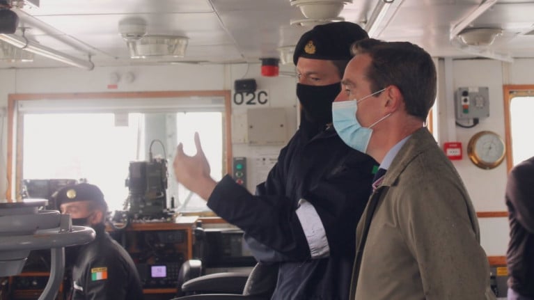
The broadcaster of the Ryan Tubridy Show on RTE Radio 1, spoke on his programme this morning following his naval tour-trip, citing a limited knowledge of nautical terms. This was clearly demonstrated when boarding LÉ Ciara in Dun Laoghaire Harbour where he mentioned 'boat' but the crew corrected him with a reply of 'ship'.

Despite the introductory slip-up, Ryan was clearly impressed of the work involved in the Naval Service as crew of the LÉ Ciara gave him an insightful tour. This included the bridge, mess-room and the galley, where the menu is constantly changing, given the variety is all too important to keep a crew of 39 (including 5 Officers) content while working at sea.

Among the equipment highlighted on the bridge, was the satelitte tracking of ships represented by 'lights' as Tubridy refered to, however the distinct absence of such notably off the south-west coast was due to Storm Ellen, which kept fishing vessels decidely away from such dangerous seas.

It was during yesterday morning that Afloat routinely tracked online shipping, among them LÉ Ciara to Dun Laoghaire Harbour and by concidence this took place shortly before listening to the Tubridy Show discussing the pending invite from the Naval Service.

Prior to this, LÉ Ciara had sailed from Cork Harbour to Dun Laoghaire Harbour where the radio presenter (to grace TV screens in September with RTE's flagship 'Late Late Show') was taken out on a short coastal trip into Dublin Bay. This included a transit through Dalkey Sound which took place before noon which then led the Coastal Patrol Vessel (CPV) return to Dun Laoghaire Harbour having rounded Dalkey Island.

It was in these same waters where Afloat reported last week, a rockfall incident within Coliemore Harbour, Dalkey which forced the temporary closure of the passenger ferryboat service to the island 300m offshore. This remains so also given the tail end of Storm Ellen.

As for LÉ Ciara, the sleek CPV has been in the Naval Service for more than 30 years, following an initial career albeit brief of just 4 years with the UK Royal Navy's Hong Kong Patrol Squadron before its Irish role where the ship was not the only ship in Dun Laoghaire Harbour yesterday as outlined below.

Firstly though was the excursion vessel, St. Bridget of Dublin Bay Cruises that was berthed ahead of LÉ Ciara while routinely alongside St. Michael's Pier, though given the increasingly inclement weather not surprisingly no cruises took place among them around Dalkey Island. The bad weather led St. Bridget yesterday afternoon make a 'repositioning' short passage across Dublin Bay to take a berth in the capital port next to the tug, Giano as Afloat has also reported.

While back in Dun Laoghaire Harbour the homeport of ILV Granuaile which berthed at Carlisle Pier and where nearby the Commissioners of Irish Lights operate the tender from their headquarters located beside the port's marina. Asides leisure craft and yachts is the former Dutch barge Stella at the 'Coal' Harbour and a former UK based Thames lighter tug, Swiftstone which is undergoing restoration as a 'heritage' tug.

The UK connection continues as L.É. Ciara was formerly a Royal Navy vessel HMS Swallow stationed in the waters of Hong Kong as part of a coastal patrol squadron based at the former colony. The 62m vessel which has a shallow draft of 2.7m, was acquired by the Irish Government in 1988 and the CPV celebrated more than three decades in service as Afloat previously highlighted in recent years.

L.É. Ciara's primary armament consists of a 76mm OTO Melara compact gun mounted at the fo'c'sle near the bow in addition a Canon Radamec Fire Control System. As for service speed is given as 25 knots but can be more.

Following the media-naval rendez-vous, Afloat observed the L.É. Ciara re-enter Dublin Bay yesterday as the CPV at almost 14.15 was offshore of The Muglins where a lightbeacon is located on the rocky islet to the east of Dalkey Island.  For more on local coastal matters, see: 'Maritime' Dalkey series (2011-2016) published in the Dalkey Community Council Newsletters.

According to online tracking, L.É. Ciara headed back to its homeport of Cork Harbour as Storm Ellen progressed, though the CPV arrived just before 2300hrs last night where the small ship remains at anchorage.

Published in Navy

Dublin Bay

Dublin Bay on the east coast of Ireland stretches over seven kilometres, from Howth Head on its northern tip to Dalkey Island in the south. It's a place most Dubliners simply take for granted, and one of the capital's least visited places. But there's more going on out there than you'd imagine.

The biggest boating centre is at Dun Laoghaire Harbour on the Bay's south shore that is home to over 1,500 pleasure craft, four waterfront yacht clubs and Ireland's largest marina.

The bay is rather shallow with many sandbanks and rocky outcrops, and was notorious in the past for shipwrecks, especially when the wind was from the east. Until modern times, many ships and their passengers were lost along the treacherous coastline from Howth to Dun Laoghaire, less than a kilometre from shore.

The Bay is a C-shaped inlet of the Irish Sea and is about 10 kilometres wide along its north-south base, and 7 km in length to its apex at the centre of the city of Dublin; stretching from Howth Head in the north to Dalkey Point in the south. North Bull Island is situated in the northwest part of the bay, where one of two major inshore sandbanks lie, and features a 5 km long sandy beach, Dollymount Strand, fronting an internationally recognised wildfowl reserve. Many of the rivers of Dublin reach the Irish Sea at Dublin Bay: the River Liffey, with the River Dodder flow received less than 1 km inland, River Tolka, and various smaller rivers and streams.

Dublin Bay FAQs

There are approximately ten beaches and bathing spots around Dublin Bay: Dollymount Strand; Forty Foot Bathing Place; Half Moon bathing spot; Merrion Strand; Bull Wall; Sandycove Beach; Sandymount Strand; Seapoint; Shelley Banks; Sutton, Burrow Beach

There are slipways on the north side of Dublin Bay at Clontarf, Sutton and on the southside at Dun Laoghaire Harbour, and in Dalkey at Coliemore and Bulloch Harbours.

Dublin Bay is administered by a number of Government Departments, three local authorities and several statutory agencies. Dublin Port Company is in charge of navigation on the Bay.

Dublin Bay is approximately 70 sq kilometres or 7,000 hectares. The Bay is about 10 kilometres wide along its north-south base, and seven km in length east-west to its peak at the centre of the city of Dublin; stretching from Howth Head in the north to Dalkey Point in the south.

Dun Laoghaire Harbour on the southside of the Bay has an East and West Pier, each one kilometre long; this is one of the largest human-made harbours in the world. There also piers or walls at the entrance to the River Liffey at Dublin city known as the Great North and South Walls. Other harbours on the Bay include Bulloch Harbour and Coliemore Harbours both at Dalkey.

There are two marinas on Dublin Bay. Ireland's largest marina with over 800 berths is on the southern shore at Dun Laoghaire Harbour. The other is at Poolbeg Yacht and Boat Club on the River Liffey close to Dublin City.

Car and passenger Ferries operate from Dublin Port to the UK, Isle of Man and France. A passenger ferry operates from Dun Laoghaire Harbour to Howth as well as providing tourist voyages around the bay.

Dublin Bay has two Islands. Bull Island at Clontarf and Dalkey Island on the southern shore of the Bay.

The River Liffey flows through Dublin city and into the Bay. Its tributaries include the River Dodder, the River Poddle and the River Camac.

Dollymount, Burrow and Seapoint beaches

Approximately 1,500 boats from small dinghies to motorboats to ocean-going yachts. The vast majority, over 1,000, are moored at Dun Laoghaire Harbour which is Ireland's boating capital.

In 1981, UNESCO recognised the importance of Dublin Bay by designating North Bull Island as a Biosphere because of its rare and internationally important habitats and species of wildlife. To support sustainable development, UNESCO’s concept of a Biosphere has evolved to include not just areas of ecological value but also the areas around them and the communities that live and work within these areas. There have since been additional international and national designations, covering much of Dublin Bay, to ensure the protection of its water quality and biodiversity. To fulfil these broader management aims for the ecosystem, the Biosphere was expanded in 2015. The Biosphere now covers Dublin Bay, reflecting its significant environmental, economic, cultural and tourism importance, and extends to over 300km² to include the bay, the shore and nearby residential areas.

On the Southside at Dun Laoghaire, there is the National Yacht Club, Royal St. George Yacht Club, Royal Irish Yacht Club and Dun Laoghaire Motor Yacht Club as well as Dublin Bay Sailing Club. In the city centre, there is Poolbeg Yacht and Boat Club. On the Northside of Dublin, there is Clontarf Yacht and Boat Club and Sutton Dinghy Club. While not on Dublin Bay, Howth Yacht Club is the major north Dublin Sailing centre.

© Afloat 2020