Menu

Ireland's sailing, boating & maritime magazine

Dublin Bay Boating News and Information

Displaying items by tag: Tata Steel Port Talbot

#SteelPort - Upgrading infrastructure work at ABP’s port of Newport, south Wales involved an engineering firm from Port Talbot where also located is the giant steelworks of Tata Steel whose 4,000 strong workforce recieved much welcomed news yesterday, writes Jehan Ashmore.

The Welsh workforce were given a commitment to job security and across Tata’s other UK plants according to BBC News. It could bring an end to eight months of uncertainty for thousands of workers who faced losing their jobs when Tata's UK business was put up for sale. Tata held talks with unions yesterday (Wednesday) and said it was "an important step forward" for its future in the UK. But workers still have to agree to pensions changes and will be balloted.

Almost 7,000 people are employed by Tata Steel across Wales, including those in Port Talbot, to read more click here. The port located between Swansea and Barry (see former Seaspeed Ferries) along with Cardiff and Newport make up ABP South Wales five ports handling more than 13 million tonnes of cargo annually. In total Associated British Ports group has 21 ports throughout the UK.

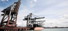
It is at this Bristol Channel port one of only a few harbours in the UK that Port Talbot is capable of handling cape-size vessels of up to 170,000dwt. The two 300m long berth of the deepwater jetty built in the 1970’s is predominantly for importing coking coal, minerals and ores to the Tata plant which is Indian owned.

On the other side of the Celtic Sea, the last such steel works in the Republic was the Irish Steel plant in Cork Harbour. The factory on Haulbowline Island was on a site of a former 1869 dockyard neighbouring the Naval Service Base. The plant’s last owners ISPAT /Irish Steel, also an Indian owned business had a workforce of 400 until closing in 2001 with accumulated losses of £10m.

A legacy of such heavy industry remains as Afloat reported in January of the then Marine Minister Simon Coveney announcment of a two-and-a-half-year programme of core remediation works during a meeting with the Haulbowline Remediation Project Stakeholders Group. 

Remediation of the contaminated waste site is to be completed by mid-2018. This followed a Government decision to provide a total of €61 million to remediate the location on a “whole of Island basis”, incorporating both the east and south tips and including a ground level remediation of the former factory site.

The eyesore of the spoil site on the eastern end of Haulbowline Island over the years could easily be seen by tourists on board inbound Brittany Ferries Roscoff-Cork seasonal-only sailings.

Flagship Pont-Aven whose environmental credentials consist of funnel sulphur emission ‘scrubber’ technology which was installed before this season. The 'green' measures were taken so to comply with an EU Directive on Sulphur Emissions.

The Ireland-France seasonal connection has been extended over the years with sailings running up to early November. Sailings on the continental service are to resume in April 2017.


Published in Ports & Shipping

Dublin Bay

Dublin Bay on the east coast of Ireland stretches over seven kilometres, from Howth Head on its northern tip to Dalkey Island in the south. It's a place most Dubliners simply take for granted, and one of the capital's least visited places. But there's more going on out there than you'd imagine.

The biggest boating centre is at Dun Laoghaire Harbour on the Bay's south shore that is home to over 1,500 pleasure craft, four waterfront yacht clubs and Ireland's largest marina.

The bay is rather shallow with many sandbanks and rocky outcrops, and was notorious in the past for shipwrecks, especially when the wind was from the east. Until modern times, many ships and their passengers were lost along the treacherous coastline from Howth to Dun Laoghaire, less than a kilometre from shore.

The Bay is a C-shaped inlet of the Irish Sea and is about 10 kilometres wide along its north-south base, and 7 km in length to its apex at the centre of the city of Dublin; stretching from Howth Head in the north to Dalkey Point in the south. North Bull Island is situated in the northwest part of the bay, where one of two major inshore sandbanks lie, and features a 5 km long sandy beach, Dollymount Strand, fronting an internationally recognised wildfowl reserve. Many of the rivers of Dublin reach the Irish Sea at Dublin Bay: the River Liffey, with the River Dodder flow received less than 1 km inland, River Tolka, and various smaller rivers and streams.

Dublin Bay FAQs

There are approximately ten beaches and bathing spots around Dublin Bay: Dollymount Strand; Forty Foot Bathing Place; Half Moon bathing spot; Merrion Strand; Bull Wall; Sandycove Beach; Sandymount Strand; Seapoint; Shelley Banks; Sutton, Burrow Beach

There are slipways on the north side of Dublin Bay at Clontarf, Sutton and on the southside at Dun Laoghaire Harbour, and in Dalkey at Coliemore and Bulloch Harbours.

Dublin Bay is administered by a number of Government Departments, three local authorities and several statutory agencies. Dublin Port Company is in charge of navigation on the Bay.

Dublin Bay is approximately 70 sq kilometres or 7,000 hectares. The Bay is about 10 kilometres wide along its north-south base, and seven km in length east-west to its peak at the centre of the city of Dublin; stretching from Howth Head in the north to Dalkey Point in the south.

Dun Laoghaire Harbour on the southside of the Bay has an East and West Pier, each one kilometre long; this is one of the largest human-made harbours in the world. There also piers or walls at the entrance to the River Liffey at Dublin city known as the Great North and South Walls. Other harbours on the Bay include Bulloch Harbour and Coliemore Harbours both at Dalkey.

There are two marinas on Dublin Bay. Ireland's largest marina with over 800 berths is on the southern shore at Dun Laoghaire Harbour. The other is at Poolbeg Yacht and Boat Club on the River Liffey close to Dublin City.

Car and passenger Ferries operate from Dublin Port to the UK, Isle of Man and France. A passenger ferry operates from Dun Laoghaire Harbour to Howth as well as providing tourist voyages around the bay.

Dublin Bay has two Islands. Bull Island at Clontarf and Dalkey Island on the southern shore of the Bay.

The River Liffey flows through Dublin city and into the Bay. Its tributaries include the River Dodder, the River Poddle and the River Camac.

Dollymount, Burrow and Seapoint beaches

Approximately 1,500 boats from small dinghies to motorboats to ocean-going yachts. The vast majority, over 1,000, are moored at Dun Laoghaire Harbour which is Ireland's boating capital.

In 1981, UNESCO recognised the importance of Dublin Bay by designating North Bull Island as a Biosphere because of its rare and internationally important habitats and species of wildlife. To support sustainable development, UNESCO’s concept of a Biosphere has evolved to include not just areas of ecological value but also the areas around them and the communities that live and work within these areas. There have since been additional international and national designations, covering much of Dublin Bay, to ensure the protection of its water quality and biodiversity. To fulfil these broader management aims for the ecosystem, the Biosphere was expanded in 2015. The Biosphere now covers Dublin Bay, reflecting its significant environmental, economic, cultural and tourism importance, and extends to over 300km² to include the bay, the shore and nearby residential areas.

On the Southside at Dun Laoghaire, there is the National Yacht Club, Royal St. George Yacht Club, Royal Irish Yacht Club and Dun Laoghaire Motor Yacht Club as well as Dublin Bay Sailing Club. In the city centre, there is Poolbeg Yacht and Boat Club. On the Northside of Dublin, there is Clontarf Yacht and Boat Club and Sutton Dinghy Club. While not on Dublin Bay, Howth Yacht Club is the major north Dublin Sailing centre.

© Afloat 2020