Displaying items by tag: Valentia Island
Valentia Island Energy Project Applies for Site Investigation Permit for Floating Wind Farm
A community-led renewable energy project on Kerry’s Valentia island which is seeking to build a floating offshore wind farm has applied for permission to conduct site investigations.
The Valentia Island Energy Ltd Project states in its application that it recognises that there are no constructed offshore renewable energy sites closer to shore, but believes “strongly” in the “potential of offshore floating technology”.
It says floating wind can reduce concerns about visual impact, due to distance offshore, while generating “sustainable energy responsibly”.
It says the proposed project will develop in two phases - both inside and outside the 12 nautical mile limit, with the second phase, outside the 12-mile limit, requiring a separate investigatory license.
The first phase may comprise two separate arrays of 92 floating wind turbines, with 56 of these located over a 96 km² area, and 36 turbines over a 138 km² area.
It is estimated this first phase would generate around 920 MW of energy.
The second phase will be located outside the 12 nautical-mile limit in an area occupying c. 161 km², involving about 62 floating turbines with an estimated power output of 620 MW.
It says the development area was identified as it has suitable water depths for floating wind technology, and an “appropriate wind resource/speed”.
The total area also has “suitable seabed morphology “, “suitable wave conditions”, avoids heavy marine traffic and it close to a deepwater port as in Foynes.
Valentia Island Energy Ltd says in its application that stakeholder engagement will take place, and recognises that geophysical and geotechnical surveys “may temporarily interact with the use of space of other marine users.
It says it will issue marine notices to the Maritime Safety Directorate, “as well as actively engaging with local fishing organisations, fisheries representative groups and local harbour authorities to notify other marine users of our presence and schedule of work”.
It says a fisheries liaison officer has been retained and will carry out stakeholder engagement with BIM, local fisheries groups, aquaculture companies, fish producer organisations and the SFPA among others,” informing stakeholders of the survey timelines and assessing potential impact which will then be mitigated where possible”.
Details of the site investigation works application are HERE
A pair of killer whales from a unique group have been sighted off the Kerry coast, as Radio Kerry reports.
The Irish Whale and Dolphin Group (IWDG) has identified the two male orcas seen off Bray Head on Valentia Island this week as the last known surviving members of the Scottish West Coast Community Group.
And according to the Mirror, it marks the second sighting for the pair in this area within the last three months.
Studied for years by marine scientists due to isolation their genetic distinctiveness from other orcas in the North Atlantic region, these marine mammals commonly feed in the Hebridean Islands.
Killer whales return to Bray Head, Valentia Island, Co. Kerry!
— Irish Whale and Dolphin Group (@IWDGnews) July 21, 2022
Thanks to Nicky Sheehan from Skellig Michael Cruises and Dr.Connie Kelleher for reporting their sightings to us.These sightings provide insight into how killer whales forage both in Irish coastal waters and elsewhere. pic.twitter.com/9AdtWrS72P
But they’ve previously been found as far as Scotland’s east coast, Lough Swilly in Donegal and four years ago off the Blasket Islands, likely in search of food.
Experts have feared for some time that this orca pod has been nearing its end. It last calved more than 30 years ago and has shrunk from around 20 individuals in the 1980s to just two known members, John Coe and Aquarius, as of 2016.
Valentia Island Heritage Centre To Open at Easter
Valentia Island Heritage Centre in County Kerry intends to open for this year’s season during Easter.
A ‘Heritage Week’ is being planned for this year and will feature stories from the lifetimes of island residents.
The Centre has received donations of a number of artefacts, including about the local fishing industry and a collection of poetry and folklore of the local area of Beginnis.
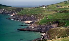
Valentia Island is located on the Skellig Coast in the Southern Peninsula of the Wild Atlantic Way adjacent to the Ring of Kerry.
Arctic Walrus Spotted on Co Kerry Coast
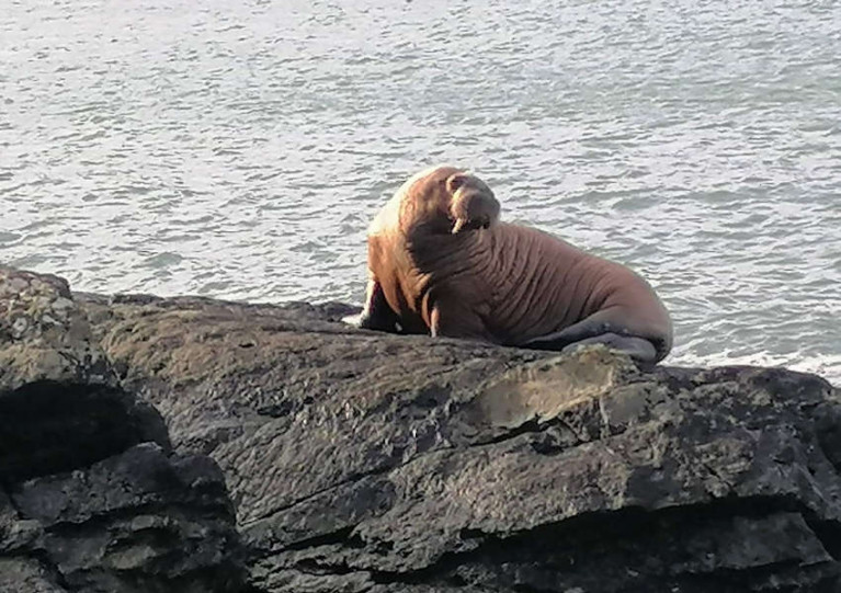
Some lucky passers-by were treated to the extraordinary sight of an Arctic walrus on rocks at Valentia Island in Co Kerry yesterday, Sunday 14 March.
Video of the marine wildlife — which resembles a large seal but for its obvious tusks — shows it in what appears to be an exhausted state, far from its usual haunts across the North Atlantic in Greenland, as RTÉ News reports.
It’s not the first time an Arctic walrus has been spotted in Irish waters.
A walrus was spotted ashore at Knightstown, Valentia Island, Co. Kerry today. This Artctic species is an infrequent visitor to Irish waters, with 11 records in our database, dating back to 1897. #ExploreYourShoreIRL at https://t.co/kRStl5Mk06 pic.twitter.com/xseQaZUC3a
— Biodiversity Ireland (@BioDataCentre) March 14, 2021
But the National Biodiversity Data Centre says there have been only 11 confirmed records in its database since 1897.
A walrus in west Cork in 1930... and one that was shot out near Dursey Island. https://t.co/wgtqYtGk7n
— Seán Mac an tSíthigh (@Buailtin) March 14, 2021
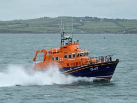
Valentia RNLI volunteers launched their all-weather lifeboat Saturday evening (8 May) to assist a fisherman with crush injuries to the chest on board a fishing trawler.
At 7.28pm the Valentia Coast Guard requested Valentia RNLI all-weather lifeboat to launch to an injured fisherman on board a 34-metre French fishing trawler. The vessel at the time was 32 miles west of Valentia. Weather conditions at the time were good with clear visibility, a force four North West wind and a three-metre swell.
Once on scene, one of our lifeboat crew members was transferred to the fishing trawler to administer casualty care to the injured fisherman who had sustained crush injuries to the chest. The lifeboat crew member assessed and treated the fisherman for the injuries he sustained, while liaising with doctors in CUH on the fisherman’s condition. Keeping weather conditions in mind and the condition of the fisherman, it was decided that the best course of treatment would be to airlift the patient to the nearest emergency department.
Irish Coast Guard helicopter Rescue 115 was tasked to the incident and rendezvoused with the trawler. The winchman/paramedic was lowered onto the deck of the vessel and taken below deck to the fisherman. With the assistance of the lifeboat crew, the injured man was brought out on deck and winched on board the helicopter. The fisherman was then airlifted to University Hospital Kerry for further treatment.
Speaking following the call out, Valentia RNLI Coxswain Richard Quigley said: The volunteer crew responded quickly and made the fisherman, who was in a great deal of pain as comfortable as possible until they were able to hand over to the Irish Coast Guard.
Valentia Island Aims to Lead Way in Hydrogen Energy Use
#islandnews - An island off Co. Kerry is aiming to produce clean energy which could be used to power public lighting and propel its ferry service, among other uses.
As the Irish Examiner writes, Valentia Island is planning to transform its energy needs through a potential hydrogen-based product.
The project which is community-led is based on a successful venture which has been continuing and developing on Scotland’s Orkney Islands since 2016.
Details of the proposed energy model will be outlined tomorrow in The Royal Hotel Valentia Function Room on the island in south Kerry.
The ultimate goal is to power the island, said Colum O’Connell, chairman of the Valentia Energy Group.
He said islanders would be able to pull up at hydrogen refuelling stations just as Orkney islanders currently do. Mr O’Connell said in the not-too-distant future Valentia could eventually be a powerhouse for storing and selling on the clean energy.
More on the story can be read here.

#MarineScience - Pioneering marine biologist Maude Delap is the focus of an exhibition celebrating her work at her former home of Valentia Island this Saturday (18 August), as The Irish Times reports.
The self-taught Delap, who was born in Donegal in 1866, was a preeminent marine scientist of the Victorian era, renowned in particular for her studies on the life cycle of jellyfish.
But her interests also extended to other plant and wildlife, as well as Irish folklore and archaeology — all of which is reflected in the exhibition of photographs by Brian Stone accompanied by music from composer Seán Ó Dálaigh as art of the Valentia Chamber Music Festival.
The Irish Times has much more on the story HERE.
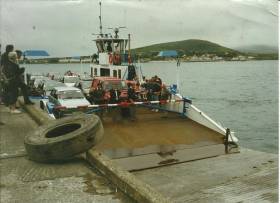
#ValentiaFerry - There are concerns over the future of the Valentia Island carferry service as the vessel of more than 50 years will no longer meet marine safety requirements, reported RTE Six One News.
Islanders of the Co. Kerry island say that tourism would collapse if State funding is not met to fund a replacement ferry that is expected to cost in the region of €3 million. The figure is beyond the reach of the island community, however the operator of the ferry, Valentia Island Ferries say they can contribute €1m but they are seeking State assistance for the remaining €2m.
The service linking Reenard on the mainland to Knightstown on Valentia Island only takes seven minutes, was established by five island families in 1996. Richard Foran of Valentia Island Ferries said that last year they carried 100,000 cars and that represented around 250,000 passengers.
While the island can be accessed by a bridge on the western end, the islanders and tourist alike benefit from the ferry service that reduces the distance to Cahersiveen by 13 miles. The loop created is according to the islanders essential to the Skellig Ring and the Wild Atlantic Way.
Valentia Harbour is on the south side of the entrance to Dingle Bay, in a sheltered area between the Valentia Island and the mainland. Knightstown is a fishing port and is the Island's only settlement. It provides visiting yachts with a sheltered anchorage and moorings. There is the outline of a marina (the floating breakwaters) there and they are sometimes used for berthing.
Body Found in Search for Missing Angler Off Valentia Island

#MISSING FISHERMAN - Search teams combing the coast off Valentia Island for a missing fisherman have this afternoon found the body of a man, according to the Irish Examiner.
A major search operation was launched last night after the 32-year-old angler slipped and fell into the water while fishing with a group of seven at Culloo Rock off the Co Kerry island.
Garda and Naval Service divers this afternoon joined the search, which resumed at 6am headed by the Valentia lifeboat and Kingstown coastguard unit, with assistance from the Waterford-based Irish Coast Guard rescue helicopter.
The body recovered by divers has not yet been identified.
Lifeboat operations manager Richard Foran said the area is notorious for people losing lives, as the Belfast Telegraph reports.
"It's a fantastic fishing, spot but the problem is it is exposed to the Atlantic," he said.


