Menu

Ireland's sailing, boating & maritime magazine

Dublin Bay Boating News and Information

Displaying items by tag: WhaleTrack Ireland

The Irish Whale and Dolphin Group (IWDG) is seeking a new sponsor for its “pioneering” WhaleTrack Ireland project.

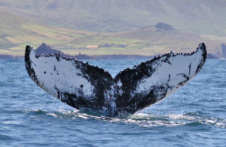
Previously backed by Ryanair, WhaleTrack Ireland seeks to understand how the large marine wildlife — especially humpback whales — are using Irish waters, largely through citizen science.

During the last 12 months, the IWDG says it has increased its work raising awareness of humpback whales “to unprecedented levels in Ireland”.

This includes the first ever confirmation of breeding grounds in Cape Verde for whales that frequent Irish shores.

“In order to continue this important work the IWDG need a new sponsor,” the group says.

“We have significant capital equipment purchased under the Ryanair sponsorship but require funds to support fieldwork and maintain our photo ID catalogues and provide support to our citizen scientists.

“This work supports the development of marine tourism in Ireland and greatly enhances the opportunities to go and see these magnificent creatures as well as ensuring their long-term conservation.

“The IWDG estimates that this costs around €40,000 per annum to maintain our current level of activity.”

Prospective sponsors, or those who could connect the group with same, are encouraged to get in touch with the IWDG at [email protected].

Published in Marine Wildlife

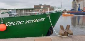
The RV Celtic Voyager departed early this morning (Thursday 1 August) from the Port of Cork on a multidisciplinary marine wildlife survey investigating the biological and oceanographic features of the 100m contour line between Cork to Galway.

The survey team comprises scientists and students from the Irish Whale and Dolphin Group (IWDG), Galway-Mayo Institute of Technology’s Marine and Freshwater Research Centre and NUI Galway’s Department of Earth and Ocean Sciences.

And they are hoping to learn more about what’s an apparent biodiversity hotspot, attracting the top marine predators in Irish waters from large predatory fish to seabirds and cetaceans.

Inspiration for the survey came from the regular occurrence of humpback whales observed near the 100m depth contour line, especially off West Kerry, and the team hopes to learn if this is consistent along the whole contour.

During the survey, which can be followed at the Scientists@Sea blog, visual survey teams will record marine mammals and seabirds from the deck, and a hydrophone will be towed to record any vocalising whales and dolphins.

Physical oceanography will be recorded through CTD casts along six east-west transects during the night. If fish marks coincide with concentrations of marine predators, it’s hoped they will reveal what species are feeding and what they’re feeding on.

This survey also contributes to the IWDG’s WhaleTrack Ireland project, funded by Ryanair through its Carbon Carbon Offset Programme.

Published in Marine Science

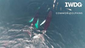
Whale watchers have captured spectacular aerial video of a group of humpback whales spotted “socialising” off West Cork.

The Irish Whale and Dolphin Group’s science officer Seán O’Callaghan filmed the remarkable scene last month just days after the first humpback whale sighing of the year was made in the same region, sailing out of Reen Pier.

“We had perfect sea conditions to search for cetaceans (whales, dolphins and porpoises) but our efforts to spot distant large whale blows were hampered by Saharan sand that caused a thick haze at sea,” the IWDG said.

“However, we did connect with up to six humpback whales feeding and socialising in offshore waters which allowed us to collect the first set of aerial images and video that will be used to estimate the length and body condition of these iconic giants.”

The video shows four of the humpback whales interacting with each other while common dolphins swim just ahead and among them.

And it marks the first significant contribution to WhaleTrack Ireland — the IWDG’s new drone-based citizen science project, supported by Ryanair, which aims to find out what these and other marine wildlife giants are doing within and beyond Irish waters.

Published in West Cork

Dublin Bay

Dublin Bay on the east coast of Ireland stretches over seven kilometres, from Howth Head on its northern tip to Dalkey Island in the south. It's a place most Dubliners simply take for granted, and one of the capital's least visited places. But there's more going on out there than you'd imagine.

The biggest boating centre is at Dun Laoghaire Harbour on the Bay's south shore that is home to over 1,500 pleasure craft, four waterfront yacht clubs and Ireland's largest marina.

The bay is rather shallow with many sandbanks and rocky outcrops, and was notorious in the past for shipwrecks, especially when the wind was from the east. Until modern times, many ships and their passengers were lost along the treacherous coastline from Howth to Dun Laoghaire, less than a kilometre from shore.

The Bay is a C-shaped inlet of the Irish Sea and is about 10 kilometres wide along its north-south base, and 7 km in length to its apex at the centre of the city of Dublin; stretching from Howth Head in the north to Dalkey Point in the south. North Bull Island is situated in the northwest part of the bay, where one of two major inshore sandbanks lie, and features a 5 km long sandy beach, Dollymount Strand, fronting an internationally recognised wildfowl reserve. Many of the rivers of Dublin reach the Irish Sea at Dublin Bay: the River Liffey, with the River Dodder flow received less than 1 km inland, River Tolka, and various smaller rivers and streams.

Dublin Bay FAQs

There are approximately ten beaches and bathing spots around Dublin Bay: Dollymount Strand; Forty Foot Bathing Place; Half Moon bathing spot; Merrion Strand; Bull Wall; Sandycove Beach; Sandymount Strand; Seapoint; Shelley Banks; Sutton, Burrow Beach

There are slipways on the north side of Dublin Bay at Clontarf, Sutton and on the southside at Dun Laoghaire Harbour, and in Dalkey at Coliemore and Bulloch Harbours.

Dublin Bay is administered by a number of Government Departments, three local authorities and several statutory agencies. Dublin Port Company is in charge of navigation on the Bay.

Dublin Bay is approximately 70 sq kilometres or 7,000 hectares. The Bay is about 10 kilometres wide along its north-south base, and seven km in length east-west to its peak at the centre of the city of Dublin; stretching from Howth Head in the north to Dalkey Point in the south.

Dun Laoghaire Harbour on the southside of the Bay has an East and West Pier, each one kilometre long; this is one of the largest human-made harbours in the world. There also piers or walls at the entrance to the River Liffey at Dublin city known as the Great North and South Walls. Other harbours on the Bay include Bulloch Harbour and Coliemore Harbours both at Dalkey.

There are two marinas on Dublin Bay. Ireland's largest marina with over 800 berths is on the southern shore at Dun Laoghaire Harbour. The other is at Poolbeg Yacht and Boat Club on the River Liffey close to Dublin City.

Car and passenger Ferries operate from Dublin Port to the UK, Isle of Man and France. A passenger ferry operates from Dun Laoghaire Harbour to Howth as well as providing tourist voyages around the bay.

Dublin Bay has two Islands. Bull Island at Clontarf and Dalkey Island on the southern shore of the Bay.

The River Liffey flows through Dublin city and into the Bay. Its tributaries include the River Dodder, the River Poddle and the River Camac.

Dollymount, Burrow and Seapoint beaches

Approximately 1,500 boats from small dinghies to motorboats to ocean-going yachts. The vast majority, over 1,000, are moored at Dun Laoghaire Harbour which is Ireland's boating capital.

In 1981, UNESCO recognised the importance of Dublin Bay by designating North Bull Island as a Biosphere because of its rare and internationally important habitats and species of wildlife. To support sustainable development, UNESCO’s concept of a Biosphere has evolved to include not just areas of ecological value but also the areas around them and the communities that live and work within these areas. There have since been additional international and national designations, covering much of Dublin Bay, to ensure the protection of its water quality and biodiversity. To fulfil these broader management aims for the ecosystem, the Biosphere was expanded in 2015. The Biosphere now covers Dublin Bay, reflecting its significant environmental, economic, cultural and tourism importance, and extends to over 300km² to include the bay, the shore and nearby residential areas.

On the Southside at Dun Laoghaire, there is the National Yacht Club, Royal St. George Yacht Club, Royal Irish Yacht Club and Dun Laoghaire Motor Yacht Club as well as Dublin Bay Sailing Club. In the city centre, there is Poolbeg Yacht and Boat Club. On the Northside of Dublin, there is Clontarf Yacht and Boat Club and Sutton Dinghy Club. While not on Dublin Bay, Howth Yacht Club is the major north Dublin Sailing centre.

© Afloat 2020