Menu

Ireland's sailing, boating & maritime magazine

Dublin Bay Boating News and Information

Displaying items by tag: Windfarm craft

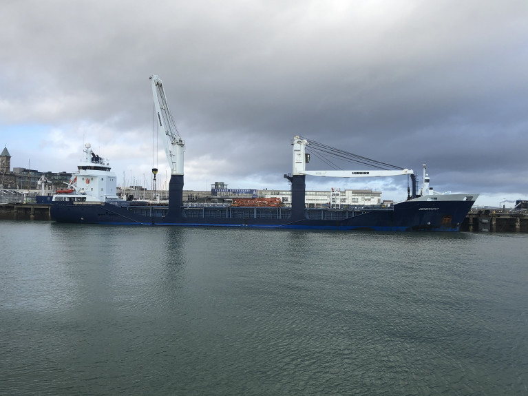
Dublin Bay saw some ships of interest today, firstly the heavy-lift general cargoship Eendracht that arrived in Dun Laoghaire Harbour today to load a part project-cargo bound for the US, writes Jehan Ashmore.

The Eendracht berthed this morning after taking a pilot from the Dublin Port cutter Liffey and according to the ships agent, the almost 3,000grt ship was scheduled to call into Dun Laoghaire Harbour.

Afloat hightlights that the arrival of a commercial vessel is relatively rare to the south Dublin Bay port, as in recent years ships have increased to the granite built harbour. The calls have been for diverse reasons, among them for maintenance to layover periods. 

As for cargo call, Eendracht only loaded 110 tons. It was much easier an exercise compared to calling to a busier Dublin Port, given the recent disruption to shipping as adverse weather battered Dublin Bay with ships forced to anchor or seek shelter elsewhere.

In fact among the affected ships was Eendracht which took shelter off Moelfre, Anglesey.

The ship had sailed from Rotterdam with part project cargo but is different to the Irish call's load.

The vessel equipped with two deck mounted heavy-lift cranes is to depart this evening and bound for the Port of Houston. One of the world's largest ports and serving the metropolitan area of Houston in Texas.

On the ferry scene, Afloat observed the Corsica-France ferry, Mega Express Four make a maiden commercial crossing this afteroon from the capital to Holyhead, while on charter to ICG's division Irish Ferries. The ferry is to provide replacement cover of the ferry fleet when off service for annual overhaul dry-dockings. 

The distinctive yellow hulled ferry made for an odd sight with it owners marketing name of Corsica Ferries/Sardinia Ferries placed amidships. This sighting took place as the ferry rounded the Dublin Bay Buoy.

About an hour later was tracked Stena Europe, transferred from a temporarily closed Rosslare-Fishguard route. This afternoon's sailing is the first to Holyhead so to enable relief cover of routine overhaul of the Irish Sea route's ferry.

Also berthed in Dun Laoghaire as a base are two vessels related to carrying out geophysical survey work for the Dublin Array -a wind farm project as Afloat previously reported.

The vessels are the Fugro Mercator, at 360 grt, is a small ship which was working offshore of Dalkey Island in seas including Killiney Bay. Fastnet Pelican formed the second vessel which is of a craft built to a catamaran design.

Published in Dublin Bay

Dublin Bay

Dublin Bay on the east coast of Ireland stretches over seven kilometres, from Howth Head on its northern tip to Dalkey Island in the south. It's a place most Dubliners simply take for granted, and one of the capital's least visited places. But there's more going on out there than you'd imagine.

The biggest boating centre is at Dun Laoghaire Harbour on the Bay's south shore that is home to over 1,500 pleasure craft, four waterfront yacht clubs and Ireland's largest marina.

The bay is rather shallow with many sandbanks and rocky outcrops, and was notorious in the past for shipwrecks, especially when the wind was from the east. Until modern times, many ships and their passengers were lost along the treacherous coastline from Howth to Dun Laoghaire, less than a kilometre from shore.

The Bay is a C-shaped inlet of the Irish Sea and is about 10 kilometres wide along its north-south base, and 7 km in length to its apex at the centre of the city of Dublin; stretching from Howth Head in the north to Dalkey Point in the south. North Bull Island is situated in the northwest part of the bay, where one of two major inshore sandbanks lie, and features a 5 km long sandy beach, Dollymount Strand, fronting an internationally recognised wildfowl reserve. Many of the rivers of Dublin reach the Irish Sea at Dublin Bay: the River Liffey, with the River Dodder flow received less than 1 km inland, River Tolka, and various smaller rivers and streams.

Dublin Bay FAQs

There are approximately ten beaches and bathing spots around Dublin Bay: Dollymount Strand; Forty Foot Bathing Place; Half Moon bathing spot; Merrion Strand; Bull Wall; Sandycove Beach; Sandymount Strand; Seapoint; Shelley Banks; Sutton, Burrow Beach

There are slipways on the north side of Dublin Bay at Clontarf, Sutton and on the southside at Dun Laoghaire Harbour, and in Dalkey at Coliemore and Bulloch Harbours.

Dublin Bay is administered by a number of Government Departments, three local authorities and several statutory agencies. Dublin Port Company is in charge of navigation on the Bay.

Dublin Bay is approximately 70 sq kilometres or 7,000 hectares. The Bay is about 10 kilometres wide along its north-south base, and seven km in length east-west to its peak at the centre of the city of Dublin; stretching from Howth Head in the north to Dalkey Point in the south.

Dun Laoghaire Harbour on the southside of the Bay has an East and West Pier, each one kilometre long; this is one of the largest human-made harbours in the world. There also piers or walls at the entrance to the River Liffey at Dublin city known as the Great North and South Walls. Other harbours on the Bay include Bulloch Harbour and Coliemore Harbours both at Dalkey.

There are two marinas on Dublin Bay. Ireland's largest marina with over 800 berths is on the southern shore at Dun Laoghaire Harbour. The other is at Poolbeg Yacht and Boat Club on the River Liffey close to Dublin City.

Car and passenger Ferries operate from Dublin Port to the UK, Isle of Man and France. A passenger ferry operates from Dun Laoghaire Harbour to Howth as well as providing tourist voyages around the bay.

Dublin Bay has two Islands. Bull Island at Clontarf and Dalkey Island on the southern shore of the Bay.

The River Liffey flows through Dublin city and into the Bay. Its tributaries include the River Dodder, the River Poddle and the River Camac.

Dollymount, Burrow and Seapoint beaches

Approximately 1,500 boats from small dinghies to motorboats to ocean-going yachts. The vast majority, over 1,000, are moored at Dun Laoghaire Harbour which is Ireland's boating capital.

In 1981, UNESCO recognised the importance of Dublin Bay by designating North Bull Island as a Biosphere because of its rare and internationally important habitats and species of wildlife. To support sustainable development, UNESCO’s concept of a Biosphere has evolved to include not just areas of ecological value but also the areas around them and the communities that live and work within these areas. There have since been additional international and national designations, covering much of Dublin Bay, to ensure the protection of its water quality and biodiversity. To fulfil these broader management aims for the ecosystem, the Biosphere was expanded in 2015. The Biosphere now covers Dublin Bay, reflecting its significant environmental, economic, cultural and tourism importance, and extends to over 300km² to include the bay, the shore and nearby residential areas.

On the Southside at Dun Laoghaire, there is the National Yacht Club, Royal St. George Yacht Club, Royal Irish Yacht Club and Dun Laoghaire Motor Yacht Club as well as Dublin Bay Sailing Club. In the city centre, there is Poolbeg Yacht and Boat Club. On the Northside of Dublin, there is Clontarf Yacht and Boat Club and Sutton Dinghy Club. While not on Dublin Bay, Howth Yacht Club is the major north Dublin Sailing centre.

© Afloat 2020