Menu

Ireland's sailing, boating & maritime magazine

Dublin Bay Boating News and Information

Displaying items by tag: promotion

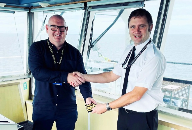
Ferry crew member, Scott Kaniewski has been promoted to the rank of Relief Master of the Isle of Man Steam Packet ro-pax Ben-my-Chree which operates between Douglas and Heysham in north-west England.

Kaniewski joined the Isle of Man Steam Packet Company in 2014 from Global Marine Systems where he worked his way up from Deck Cadet – with responsibility for cable repairs in both shallow and deep water.

In addition Scott's involvement in ship conversions and new builds, all the way up to Third Officer/Junior DPO, Second Officer and then Chief Officer.

Upon his arrival at the Steam Packet Company, Scott worked as a Second Officer and then Chief Officer on board the Ben-My-Chree.

In 2017, the Company supported his application for study leave to gain his Masters Certificate of Competency, and in 2019 he transferred to fast craft Manannan to sail as Chief Officer.

Over the past month Scott has been Master training on the Ben-My-Chree to obtain his Heysham Pilotage Certificate, and on Thursday 12th August he took command as Relief Master of the ro-pax. In the near future he will also be trained as Relief Master on Manannan.

Commenting on the promotion, the company's Managing Director Brian Thomson said: ‘Scott’s progression through the ranks is a perfect illustration of the fantastic career opportunities that are available for those who choose a career at sea.

He added "it is a truly rewarding industry for those who work hard. He is very deserving of this great achievement and we wish him many years of sailing with the Isle of Man Steam Packet Company.’

Published in Ferry
#ANGLING - A new film on fishing in south Donegal will have its premiere this Thursday, the Donegal Democrat reports.
The film, The Blue Stack Mountains, is the fourth in a series on angling in Ireland by German producer Dietrich Bohnhorst, whose previous fishing documentaries have been broadcast on television around the world.
According to Bohnhorst, who has lived in Donegal for 25 years, his latest film “describes a journey from Glenties, through Commeen, Stranorlar, Ballybofey and back over Barnesmore Gap to Donegal town."
It also pays special attention to “about 40 lakes which lie in the Blue Stacks, how to get there and where to fish, what flies to use and so on.”
Bohnhorst hopes his film will help to break the "invisible line" that he says has cut off the "under-promoted" Donegal from the marketing of angling in Ireland.
All are invited to the premiere at Solis Lough Eske Castle this Thursday at 8pm. Admission is free.

#ANGLING - A new film on fishing in south Donegal will have its premiere this Thursday, the Donegal Democrat reports.

The film, The Blue Stack Mountains, is the fourth in a series on angling in Ireland by German producer Dietrich Bohnhorst, whose previous angling documentaries have been broadcast on television around the world.

According to Bohnhorst, who has lived in Donegal for 25 years, his latest film “describes a journey from Glenties, through Commeen, Stranorlar, Ballybofey and back over Barnesmore Gap to Donegal town." 

It also pays special attention to “about 40 lakes which lie in the Blue Stacks, how to get there and where to fish, what flies to use and so on.”

Bohnhorst hopes his film will help to break the "invisible line" that he says has cut off the "under-promoted" Donegal from the marketing of angling in Ireland.

All are invited to the premiere at Solis Lough Eske Castle this Thursday at 8pm. Admission is free.

Published in Angling
A new website for Cork Harbour has been launched at CorkHarbour.ie providing up-to-dae information for local residents and anyone who uses the harbour.
The site features videos and photo galleries of habour life as well as links to groups and organisations based in the area, and intends to promote the wide range of things for locals and visitors alike to see and do both on and off the water.
The site also includes links to the harbour's new Twitter and Facebook pages to get the very latest news.
Cork Harbour spans a wide area that stretches from Roche's Point in the east, taking in the city of Cork, all the way to Fort Camden, near Crosshaven, in the west.
For more information visit CorkHarbour.ie.

A new website for Cork Harbour has been launched at CorkHarbour.ie providing up-to-dae information for local residents and anyone who uses the harbour.

The site features videos and photo galleries of habour life as well as links to groups and organisations based in the area, and intends to promote the wide range of things for locals and visitors alike to see and do both on and off the water.

The site also includes links to the harbour's new Twitter and Facebook pages to get the very latest news.

Cork Harbour spans a wide area that stretches from Roche's Point in the east, taking in the city of Cork, all the way to Fort Camden, near Crosshaven, in the west.

For more information visit CorkHarbour.ie.

Published in Cork Harbour

Dublin Bay

Dublin Bay on the east coast of Ireland stretches over seven kilometres, from Howth Head on its northern tip to Dalkey Island in the south. It's a place most Dubliners simply take for granted, and one of the capital's least visited places. But there's more going on out there than you'd imagine.

The biggest boating centre is at Dun Laoghaire Harbour on the Bay's south shore that is home to over 1,500 pleasure craft, four waterfront yacht clubs and Ireland's largest marina.

The bay is rather shallow with many sandbanks and rocky outcrops, and was notorious in the past for shipwrecks, especially when the wind was from the east. Until modern times, many ships and their passengers were lost along the treacherous coastline from Howth to Dun Laoghaire, less than a kilometre from shore.

The Bay is a C-shaped inlet of the Irish Sea and is about 10 kilometres wide along its north-south base, and 7 km in length to its apex at the centre of the city of Dublin; stretching from Howth Head in the north to Dalkey Point in the south. North Bull Island is situated in the northwest part of the bay, where one of two major inshore sandbanks lie, and features a 5 km long sandy beach, Dollymount Strand, fronting an internationally recognised wildfowl reserve. Many of the rivers of Dublin reach the Irish Sea at Dublin Bay: the River Liffey, with the River Dodder flow received less than 1 km inland, River Tolka, and various smaller rivers and streams.

Dublin Bay FAQs

There are approximately ten beaches and bathing spots around Dublin Bay: Dollymount Strand; Forty Foot Bathing Place; Half Moon bathing spot; Merrion Strand; Bull Wall; Sandycove Beach; Sandymount Strand; Seapoint; Shelley Banks; Sutton, Burrow Beach

There are slipways on the north side of Dublin Bay at Clontarf, Sutton and on the southside at Dun Laoghaire Harbour, and in Dalkey at Coliemore and Bulloch Harbours.

Dublin Bay is administered by a number of Government Departments, three local authorities and several statutory agencies. Dublin Port Company is in charge of navigation on the Bay.

Dublin Bay is approximately 70 sq kilometres or 7,000 hectares. The Bay is about 10 kilometres wide along its north-south base, and seven km in length east-west to its peak at the centre of the city of Dublin; stretching from Howth Head in the north to Dalkey Point in the south.

Dun Laoghaire Harbour on the southside of the Bay has an East and West Pier, each one kilometre long; this is one of the largest human-made harbours in the world. There also piers or walls at the entrance to the River Liffey at Dublin city known as the Great North and South Walls. Other harbours on the Bay include Bulloch Harbour and Coliemore Harbours both at Dalkey.

There are two marinas on Dublin Bay. Ireland's largest marina with over 800 berths is on the southern shore at Dun Laoghaire Harbour. The other is at Poolbeg Yacht and Boat Club on the River Liffey close to Dublin City.

Car and passenger Ferries operate from Dublin Port to the UK, Isle of Man and France. A passenger ferry operates from Dun Laoghaire Harbour to Howth as well as providing tourist voyages around the bay.

Dublin Bay has two Islands. Bull Island at Clontarf and Dalkey Island on the southern shore of the Bay.

The River Liffey flows through Dublin city and into the Bay. Its tributaries include the River Dodder, the River Poddle and the River Camac.

Dollymount, Burrow and Seapoint beaches

Approximately 1,500 boats from small dinghies to motorboats to ocean-going yachts. The vast majority, over 1,000, are moored at Dun Laoghaire Harbour which is Ireland's boating capital.

In 1981, UNESCO recognised the importance of Dublin Bay by designating North Bull Island as a Biosphere because of its rare and internationally important habitats and species of wildlife. To support sustainable development, UNESCO’s concept of a Biosphere has evolved to include not just areas of ecological value but also the areas around them and the communities that live and work within these areas. There have since been additional international and national designations, covering much of Dublin Bay, to ensure the protection of its water quality and biodiversity. To fulfil these broader management aims for the ecosystem, the Biosphere was expanded in 2015. The Biosphere now covers Dublin Bay, reflecting its significant environmental, economic, cultural and tourism importance, and extends to over 300km² to include the bay, the shore and nearby residential areas.

On the Southside at Dun Laoghaire, there is the National Yacht Club, Royal St. George Yacht Club, Royal Irish Yacht Club and Dun Laoghaire Motor Yacht Club as well as Dublin Bay Sailing Club. In the city centre, there is Poolbeg Yacht and Boat Club. On the Northside of Dublin, there is Clontarf Yacht and Boat Club and Sutton Dinghy Club. While not on Dublin Bay, Howth Yacht Club is the major north Dublin Sailing centre.

© Afloat 2020