Menu

Ireland's sailing, boating & maritime magazine

Displaying items by tag: Bandon

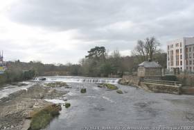
#FloodRelief - The scheduled Bandon Flood Relief Scheme work programme for 2017 has now commenced on the River Bandon in Co Cork.

The scheme consists of a combination of flood defences and dredging of the river bed to a level of 9.5m downstream of the Bandon weir (about 1.8m below the existing bed level) in the town and at a grade of 1/1,000 until it reaches the existing bed level 3.6km downstream of Bandon town.

Some 150,000 cubic metres of material will be dredged in the scheme, while new flood defences will also be constructed to contain flood water within the Bandon and Bridewell Rivers as well as the Mill Stream.

Since July 2016, Inland Fisheries Ireland’s (IFI) local representatives have attended meetings with the contractor Wills Bros Ltd, the employer’s representatives (ByrneLooby/PH McCarthy) and environmental consultants to the contractor (Rivus) to review the specific methodologies proposed to undertake the works.

While maintaining a positive approach to the Flood Relief Scheme, IFI says it made proposals in relation to the proposed methods of dredging, sediment management and solids level monitoring, in order to minimise any potential negative impact on the habitat, fish and aquatic invertebrate populations of the river.

While there is some discolouration of the River Bandon expected downstream of the works, IFI says it is reassured by ByrneLooby/PH McCarthy that the Construction Environmental Management Plan (CEMP) and agreed sediment management and solids monitoring plans are being followed.

IFI will continue monitoring dredging works and will bring any non-compliance with the conditions set out to the immediate attention of ByrneLooby/PH McCarthy to ensure corrective measures are put in place.

Any repeated or deliberate non-compliances would be dealt with by IFI using its statutory powers.

Published in Inland Waterways
Tagged under

#Flooding - Inland Fisheries Ireland has issued a statement in response to the ongoing flooding crisis across the country following last month's winter storms.

Citing its history of working "in a positive and proactive manner" with the Government, State agencies, local authorities and others on the drainage and management of surface waters, IFI says it "will work with all relevant parties in expediting emergency flood relief works."

Following the recent meeting on the Shannon flooding crisis, IFI says it has offered emergency assistance on the ground, and suggested that the Local Authority (Works) Act 1949 be used as a legal instrument by which "exemptions for emergency in stream works could be progressed".

According to IFI chief executive Dr Ciaran Byrne: “Fisheries legislation provides for a closed season for undertaking instream works. However, in emergency circumstances, such as those currently being experienced, the 1949 Act provides for the relevant minister to issue an exemption subject to taking precautions and making provisions for the protection of fisheries.”

Cork County Council has already requested exemption from the closed season for instream works from now through to the end of 2017, though IFI says that falls beyond the scope of the Act, which only provides for emergency works.

Regardless, IFI maintains that it will continue to work with Cork County Council on the removal of excess gravel from the Bandon River downstream of Bandon's old road bridge "to allay fears that these gravels may cause flooding".

IFI's statement adds that it looks forward to the successful implementation of the upcoming OPW Bandon Main Drainage Scheme.

Scheduled to begin in June this year, the works will see the rock bed of the river lowered by up to 2m in the heart of the town, tapering downstream for up to 3.5km.

This scheme was agreed several years ago and was prepared by the OPW following consultation and consultative reports. It includes provision for a fisheries habitat rehabilitation programme once the design bed levels and flood conveyance capacity are achieved.

Published in Inland Waterways

About Dublin Port 

Dublin Port is Ireland’s largest and busiest port with approximately 17,000 vessel movements per year. As well as being the country’s largest port, Dublin Port has the highest rate of growth and, in the seven years to 2019, total cargo volumes grew by 36.1%.

The vision of Dublin Port Company is to have the required capacity to service the needs of its customers and the wider economy safely, efficiently and sustainably. Dublin Port will integrate with the City by enhancing the natural and built environments. The Port is being developed in line with Masterplan 2040.

Dublin Port Company is currently investing about €277 million on its Alexandra Basin Redevelopment (ABR), which is due to be complete by 2021. The redevelopment will improve the port's capacity for large ships by deepening and lengthening 3km of its 7km of berths. The ABR is part of a €1bn capital programme up to 2028, which will also include initial work on the Dublin Port’s MP2 Project - a major capital development project proposal for works within the existing port lands in the northeastern part of the port.

Dublin Port has also recently secured planning approval for the development of the next phase of its inland port near Dublin Airport. The latest stage of the inland port will include a site with the capacity to store more than 2,000 shipping containers and infrastructures such as an ESB substation, an office building and gantry crane.

Dublin Port Company recently submitted a planning application for a €320 million project that aims to provide significant additional capacity at the facility within the port in order to cope with increases in trade up to 2040. The scheme will see a new roll-on/roll-off jetty built to handle ferries of up to 240 metres in length, as well as the redevelopment of an oil berth into a deep-water container berth.

Dublin Port FAQ

Dublin was little more than a monastic settlement until the Norse invasion in the 8th and 9th centuries when they selected the Liffey Estuary as their point of entry to the country as it provided relatively easy access to the central plains of Ireland. Trading with England and Europe followed which required port facilities, so the development of Dublin Port is inextricably linked to the development of Dublin City, so it is fair to say the origins of the Port go back over one thousand years. As a result, the modern organisation Dublin Port has a long and remarkable history, dating back over 300 years from 1707.

The original Port of Dublin was situated upriver, a few miles from its current location near the modern Civic Offices at Wood Quay and close to Christchurch Cathedral. The Port remained close to that area until the new Custom House opened in the 1790s. In medieval times Dublin shipped cattle hides to Britain and the continent, and the returning ships carried wine, pottery and other goods.

510 acres. The modern Dublin Port is located either side of the River Liffey, out to its mouth. On the north side of the river, the central part (205 hectares or 510 acres) of the Port lies at the end of East Wall and North Wall, from Alexandra Quay.

Dublin Port Company is a State-owned commercial company responsible for operating and developing Dublin Port.

Dublin Port Company is a self-financing, and profitable private limited company wholly-owned by the State, whose business is to manage Dublin Port, Ireland's premier Port. Established as a corporate entity in 1997, Dublin Port Company is responsible for the management, control, operation and development of the Port.

Captain William Bligh (of Mutiny of the Bounty fame) was a visitor to Dublin in 1800, and his visit to the capital had a lasting effect on the Port. Bligh's study of the currents in Dublin Bay provided the basis for the construction of the North Wall. This undertaking led to the growth of Bull Island to its present size.

Yes. Dublin Port is the largest freight and passenger port in Ireland. It handles almost 50% of all trade in the Republic of Ireland.

All cargo handling activities being carried out by private sector companies operating in intensely competitive markets within the Port. Dublin Port Company provides world-class facilities, services, accommodation and lands in the harbour for ships, goods and passengers.

Eamonn O'Reilly is the Dublin Port Chief Executive.

Capt. Michael McKenna is the Dublin Port Harbour Master

In 2019, 1,949,229 people came through the Port.

In 2019, there were 158 cruise liner visits.

In 2019, 9.4 million gross tonnes of exports were handled by Dublin Port.

In 2019, there were 7,898 ship arrivals.

In 2019, there was a gross tonnage of 38.1 million.

In 2019, there were 559,506 tourist vehicles.

There were 98,897 lorries in 2019

Boats can navigate the River Liffey into Dublin by using the navigational guidelines. Find the guidelines on this page here.

VHF channel 12. Commercial vessels using Dublin Port or Dun Laoghaire Port typically have a qualified pilot or certified master with proven local knowledge on board. They "listen out" on VHF channel 12 when in Dublin Port's jurisdiction.

A Dublin Bay webcam showing the south of the Bay at Dun Laoghaire and a distant view of Dublin Port Shipping is here
Dublin Port is creating a distributed museum on its lands in Dublin City.
 A Liffey Tolka Project cycle and pedestrian way is the key to link the elements of this distributed museum together.  The distributed museum starts at the Diving Bell and, over the course of 6.3km, will give Dubliners a real sense of the City, the Port and the Bay.  For visitors, it will be a unique eye-opening stroll and vista through and alongside one of Europe’s busiest ports:  Diving Bell along Sir John Rogerson’s Quay over the Samuel Beckett Bridge, past the Scherzer Bridge and down the North Wall Quay campshire to Berth 18 - 1.2 km.   Liffey Tolka Project - Tree-lined pedestrian and cycle route between the River Liffey and the Tolka Estuary - 1.4 km with a 300-metre spur along Alexandra Road to The Pumphouse (to be completed by Q1 2021) and another 200 metres to The Flour Mill.   Tolka Estuary Greenway - Construction of Phase 1 (1.9 km) starts in December 2020 and will be completed by Spring 2022.  Phase 2 (1.3 km) will be delivered within the following five years.  The Pumphouse is a heritage zone being created as part of the Alexandra Basin Redevelopment Project.  The first phase of 1.6 acres will be completed in early 2021 and will include historical port equipment and buildings and a large open space for exhibitions and performances.  It will be expanded in a subsequent phase to incorporate the Victorian Graving Dock No. 1 which will be excavated and revealed. 
 The largest component of the distributed museum will be The Flour Mill.  This involves the redevelopment of the former Odlums Flour Mill on Alexandra Road based on a masterplan completed by Grafton Architects to provide a mix of port operational uses, a National Maritime Archive, two 300 seat performance venues, working and studio spaces for artists and exhibition spaces.   The Flour Mill will be developed in stages over the remaining twenty years of Masterplan 2040 alongside major port infrastructure projects.

Source: Dublin Port Company ©Afloat 2020.