


Displaying items by tag: Codling Wind Park
Metocean Equipment Deploying at Codling Wind Park
The Department of Transport has been advised that Codling Wind Park Limited intends to deploy metocean equipment off the coast of Wicklow as part of the consenting process for Codling Wind Park.
This equipment will be deployed from the Fastnet Sound (callsign MHXQ5) between today, Wednesday 30 June and Friday 16 July, weather window permitting.
The deployment will consist of one metocean data buoy, two wave ocean buoys and one ADCP seabed frame, which will be used to characterise the wind park area over a period of 12 months.
For more details see Marine Notice No 41 of 2021, a PDF of which can be downloaded below.
Former Arabian Gulf Buoy-Vessel Calls to Dun Laoghaire Prior to Charter Work at Codling Wind Park Project
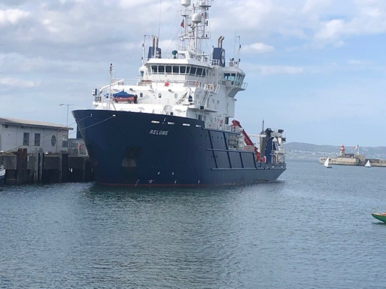
A former Arabian Gulf buoy-laying vessel, Relume that operated for the Middle East Aids to Navigation Service (MENAS) is the latest caller to Dun Laoghaire Harbour, writes Jehan Ashmore.
MENAS is the Gulf operations division of the London-based ‘International Foundation for Aids to Navigation’ (IFAN). This is the only independent Aids to Navigation authority in the world, with no country affiliation or national sponsor.
Relume was commissioned by MENAS in 2004 and was also designed with oil pollution recovery capability, hydrographic survey work and diving support, however the role of the buoy-laying vessel was to be brief.
The newbuild Relume quickly gained an enviable reputation as a combined offshore support/multi-role offhsore supply vessel (OSV) for owner /operator MENAS Marine Services Ltd (MMSL) also based in the UK capital.
By 2006 Relume relocated to the North Sea where MMSL have chartered the ship for many years and also for use on a global basis for offshore marine exploration, the oil & gas industry and emerging renewable energy sources.
A spokesperson for Dún Laoghaire-Rathdown County Council responded to Afloat's query as to the reason of the Irish call. “The Relume is berthed at No. 4 (St. Micheals Pier) for stores and crew change, following a last port of call, Thyboron, in Denmark. She is on her way to carry out survey work at the Codling Bank Wind Farm Project.” For more details, download Marine Notice No 39 of 2021 below.
At the Codling Bank is the jack-up rig, LB Jill (as Afloat previously reported), which can be observed on the horizon of Killiney Bay and off the Dublin and Wicklow coastlines.
Afloat has also confirmed from the ship agents, that the Relume will be on charter at the Codling Bank Wind Farm project for a two-month timeframe.
As of this morning, Relume had been expected to depart Dun Laoghaire Harbour where the Commissioners of Irish Lights (CIL) aids to navigation bouy-laying tender ILV Granuaile is homeported.
The ILV Granuaile of 2,625 gross tonnage was a prototype for larger newbuilds of the other General Lighthouse Authorities (GLA's) in addition MENAS.
The GLA's are Trinity House (England & Wales) which has the THV Galatea and the Northern Lighthouse Board (Scotland & Isle of Man) has NLV Pharos. Whereas MENAS had operated the 3,526gt Relume to service bouys and lighthouses in the Arabian Gulf and its approaches.
Both Relume and Granuaile were ordered from the same Dutch shipyard group, Damen at their shipyard, in Galati, Romania. The yard in 2000 launched the ILV Granuaile which went into service the same year and the DP Class 1 ship is currently on duty off the south-west coast.
Also not surprisingly, the vessels share similar hull dimensions, though the 82m Relume is slighty longer by 3m but both have a beam of around 16m.
As for the superstructure this differs, however Relume during MENAS based days used to have a pair of yellow funnels, likewise to ILV Granuaile sporting the livery of Irish Lights along with a white deckhouse and blue hull.
After a decade in service, Relume underwent a 12 month refit and upgrade of bow thrusters, Dynamic Positioning (DP) systems and installation of a new crane. Improvements were also made to accommodation and for personnel on board that was increased from 42 to 66. In addition the upgrade included revisions to office workspaces for clients.
In 2015 further work involved a machinery and accommodation upgrade to ensure continued competitiveness in the modern DP market.
The latest Marine Notice for works on the Codling Wind Park project advises of the deployment of metocean equipment between today, Tuesday 11 and Friday 28 May.
One wave buoy and one acoustic Doppler current profiler (ADCP) frame will be deployed and used to characterise the wind park area at the Codling Bank some 13km off Co Wicklow.
These works are being carried out on a 12-hour basis by the AMS Retriever (callsign MEHI8) which will display all appropriate shapes and lights.
The vessel will be restricted in ability to manoeuvre so all other vessels in the are are requested to keep a their distance and pass at minimum speed to reduce wash.
Further details, including relevant coordinates, are included in Marine Notice No 30 of 2021 which can be downloaded below.
Marine Notice: Lidar Buoy Deployment Off East Coast
More works are scheduled for the Codling Wind Park project, with the deployment of two lidar buoys to characterise the wind park area from this week.
Weather permitting, the Voe Vanguard (callsign MBEN9) will deploy the buoys in the Irish Sea off Co Wicklow between tomorrow, Tuesday 27 April and Friday 14 May.
Deployment operations will be conducted on a 12-hour basis. The Voe Vanguard will be restricted in ability to manoeuvre, so all vessels operating within its work area are requested to keep their distance, maintaining a safety zone around the survey vessel and pass at minimum speed to reduce vessel wash.
Throughout survey operations, the Voe Vanguard will be displaying appropriate lights and shapes. The lantern on the buoys will give out five yellow flashes every 20 seconds, visible for up to three nautical miles.
Further details including the relevant coordinates are included in Marine Notice No 29 of 2021, which is available to download below.
The latest notice follows previous advisories for geophysical surveys and geotechnical surveys over the next number of weeks for the wind farm scheme at the Codling Bank.
Following the recent notice of geophysical surveys for the Codling Wind Park comes news of a series of geotechnical surveys in the Irish Sea off Wicklow for the project set to commence tomorrow, Monday 26 April.
Works to characterise the wind park area will be conducted until Saturday 26 June, weather permitting, from the LB Jill (callsign WDH 6208) on a 24-hour basis. The vessel will display appropriate lights and shapes.
As the LB Jill will be restricted in ability to manoeuvre, all vessels operating within the work area are requested to keep their distance, maintaining a safety zone around the geotechnical investigation vessel, and pass at minimum speed to reduce vessel wash.
Further details including coordinates for the survey works are included in Marine Notice No 28 of 2021, which can be downloaded below.
Geophysical Surveys for Codling Wind Park off Dublin & Wicklow
The Department of Transport has been advised that Codling Wind Park Limited intend to conduct a series of geophysical surveys in the Irish Sea off Dublin and Wicklow from Wednesday 14 April to Wednesday 26 May, weather permitting.
This work is intended to provide options for export cable routes to possible landfall options in the areas of Poolbeg, Dun Laoghaire, Greystones and Wicklow.
A total of two vessels will be working on the project. Arctic Ocean (callsign OZGP2) will undertake geophysical operations to characterise the export cable sites (weather permitting). Survey operations will be conducted on a 24-hour basis.
Meanwhile, Faraday (callsign MJZX5) will undertake geophysical operations (weather permitting). Survey operations will be conducted on a 12-hour basis.
Throughout survey operations, the vessels will be displaying the appropriate lights and shapes. As both vessels will be towing survey equipment, they will also require large turning circles and will be restricted in their ability to manoeuvre.
All vessels operating within the work area are requested to keep their distance, maintaining at least the 500m safety zone around the survey vessel and pass at minimum speed to reduce vessel wash.
Further details including coordinated and contacts are included in Marine Notice No 21 of 2021, a PDF of which can be downloaded below.


 of 70,000 acres on the Corca Dhuibhne peninsula in west Kerry has been welcomed by Irish Lights")


 as lead helm, rounds the Fastnet Rock on the way to the overall win in 1987")

