Menu

Ireland's sailing, boating & maritime magazine

Displaying items by tag: Kowloon Bridge

The Beacon at Baltimore can be a miserable place. It's nice to see on a good Summer's day sailing by and bound for the harbour entrance, but it's different in nasty weather.

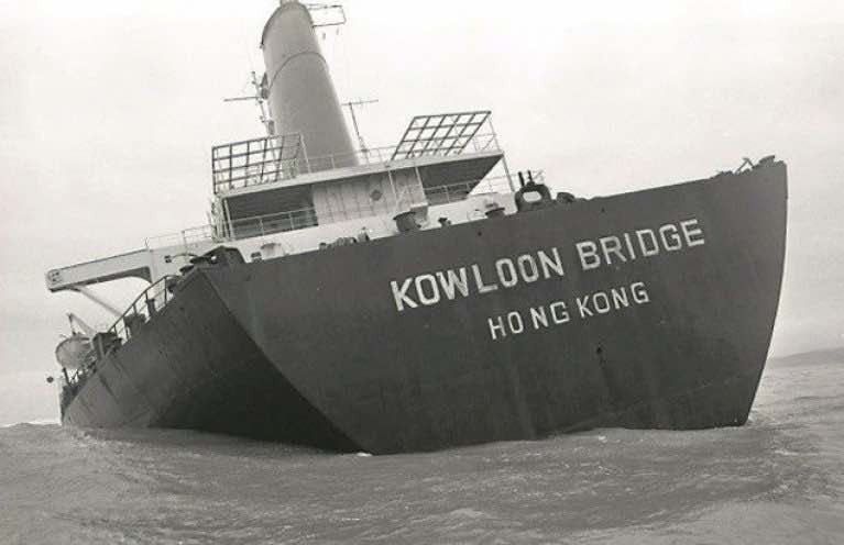
That's what I had remembered this past week - the time when an enormous vessel, 900 feet long, threatened to become a huge plug blocking that entrance.

It was around 1 a.m. on a rotten late November morning in 1986, dark, cold, wet, howling gale to brace oneself against "up at the Beacon", watching the abandoned, powerless Kowloon Bridge, driven by the power of a huge gale, towards Baltimore. She had been sheltering in Bantry Bay after damage sustained in another gale while crossing the Atlantic. She wasn't a lucky ship. Anchoring failed and, in fear of hitting another very large tanker, the Capo Emma, also sheltering in the Bay and with 80,000 tonnes of crude oil aboard, the Indian officers in charge decided to put to sea – into winds reported at 70 miles an hour, seas over 40 feet high.

The Beacon at Baltimore Harbour on the West Cork coastThe Beacon at Baltimore Harbour on the West Cork coast Photo: W M Nixon

With no luck at all, her steering failed, and the crew of 27 were rescued by RAF Sea King helicopters from the Royal Naval Air Station at Culdrose in Cornwall, then providing rescue cover in Irish waters.

I was one of the crowds of reporters, cameramen and local people that morning at the Beacon, watching the ghostly shape of the ship, seeming to be swinging towards the entrance to the West Cork Harbour. The local view was that, if it hit rocks there, Baltimore could be blocked for a long time!

Mercifully it didn't, the seas headed it eastwards, and she grounded on the Stags from where the Dutch salvage company, Smith Tak, couldn't shift it. In a few months, the seas on the West Cork coastline did that work. The Kowloon Bridge disappeared beneath the waves, worn away by its futile battle against the elements of Nature.

I recalled that in the past week when I heard of the death of a man whom I knew for many years and was one of those concerned about the Kowloon Bridge that morning. He was Richard Bushe, who died at the age of 91 died at his appropriately maritime-named home - The Cove Baltimore. His village pub, still run by the family, is one of the most well-known maritime locations in Ireland and to visitors from overseas, the place to which every sailor visiting Baltimore called. He was one of the strongest supporters of Baltimore Sailing Club since its inception in the early 1950s.

Richard BusheRichard Bushe - a strong supporter of Baltimore Sailing Club

As Charlie Bolger, Commodore of Baltimore Sailing Club wrote on the club's website: "You won't find his name amongst the list of Commodores, but Richard Bushe quietly contributed support to every Commodore with his sound advice and wisdom over the past sixty years. He was the go-to person for sailors seeking local knowledge on any topic."

Bushe's Bar has always been to me like a little maritime museum; there is so much of the lore of the sea there – maps, artefacts, items contributed by visiting and local sailors over many years. It is the go-to-place when one is in Baltimore, a place of many memories, of which Richard Bushe was certainly one.

Looking back to those days of the Kowloon Bridge, when the media centred itself at Baltimore as the story of environmental damage and pollution was reported, I also think how unprotected our waters and coastline were, how the State didn't seem to get any adequate compensation for the damage caused, there was no inquiry and Cork County Council, and its ratepayers wound up with most of the cost of €500,000. And, most of all, looking at pictures of that huge vessel, how the power of the sea at the Stags did what human endeavour couldn't do and removed that massive 900-foot vessel from sight. Today it's cargo of 160,000 tonnes of iron ore pellets, said to have been insured for stg£2.7m., still lies on the seabed.

Listen to the Podcast here.

Published in Tom MacSweeney
Tagged under
The Maritime Institute of Ireland (M.I.I.) hosts a Spring lecture series in Dublin city-centre. The next lecture is 'The Kowloon Bridge & Her Sisters' by Paddy Barry and is on this Thursday, 24 March starting at 8pm in the Stella Maris Seafarers' Club, Beresford Place.
The 89,438 tonnes dry-bulk carrier was left to founder at Staggs' Rocks (photo) off the scenic west Cork-coastline in 1986 which resulted in the pollution of those waters. Built in the 1970's by Swan Hunter, Haverton Hill, she measuered 294.13 x 44.19 x 25.01 metres and is the believed to be one of the largest wrecks in Europe. Her sisters were the Furness Bridge (photo) and Derbyshire.

The Stella Maris Seafarers' Club, Beresford Place, is located beside Busaras and faces opposite the rear of the Customs House. Nearby is the Irish Life Center (ILAC) which is convenient for car-parking and buses, the 'Red' Luas (Busaras stop) and DART stops at Connolly /Tara St. stations. All are welcome, bar and refreshments and a voluntary contribution is appreciated.

For further information about lectures and updates on the M.I.I's maritime museum located in the Mariners Church, Dun Laoghaire log on to www.mariner.ie. The museum which is due to reopen this year are looking for volunteers to help, for further details click here.

Published in Boating Fixtures

About Dublin Port 

Dublin Port is Ireland’s largest and busiest port with approximately 17,000 vessel movements per year. As well as being the country’s largest port, Dublin Port has the highest rate of growth and, in the seven years to 2019, total cargo volumes grew by 36.1%.

The vision of Dublin Port Company is to have the required capacity to service the needs of its customers and the wider economy safely, efficiently and sustainably. Dublin Port will integrate with the City by enhancing the natural and built environments. The Port is being developed in line with Masterplan 2040.

Dublin Port Company is currently investing about €277 million on its Alexandra Basin Redevelopment (ABR), which is due to be complete by 2021. The redevelopment will improve the port's capacity for large ships by deepening and lengthening 3km of its 7km of berths. The ABR is part of a €1bn capital programme up to 2028, which will also include initial work on the Dublin Port’s MP2 Project - a major capital development project proposal for works within the existing port lands in the northeastern part of the port.

Dublin Port has also recently secured planning approval for the development of the next phase of its inland port near Dublin Airport. The latest stage of the inland port will include a site with the capacity to store more than 2,000 shipping containers and infrastructures such as an ESB substation, an office building and gantry crane.

Dublin Port Company recently submitted a planning application for a €320 million project that aims to provide significant additional capacity at the facility within the port in order to cope with increases in trade up to 2040. The scheme will see a new roll-on/roll-off jetty built to handle ferries of up to 240 metres in length, as well as the redevelopment of an oil berth into a deep-water container berth.

Dublin Port FAQ

Dublin was little more than a monastic settlement until the Norse invasion in the 8th and 9th centuries when they selected the Liffey Estuary as their point of entry to the country as it provided relatively easy access to the central plains of Ireland. Trading with England and Europe followed which required port facilities, so the development of Dublin Port is inextricably linked to the development of Dublin City, so it is fair to say the origins of the Port go back over one thousand years. As a result, the modern organisation Dublin Port has a long and remarkable history, dating back over 300 years from 1707.

The original Port of Dublin was situated upriver, a few miles from its current location near the modern Civic Offices at Wood Quay and close to Christchurch Cathedral. The Port remained close to that area until the new Custom House opened in the 1790s. In medieval times Dublin shipped cattle hides to Britain and the continent, and the returning ships carried wine, pottery and other goods.

510 acres. The modern Dublin Port is located either side of the River Liffey, out to its mouth. On the north side of the river, the central part (205 hectares or 510 acres) of the Port lies at the end of East Wall and North Wall, from Alexandra Quay.

Dublin Port Company is a State-owned commercial company responsible for operating and developing Dublin Port.

Dublin Port Company is a self-financing, and profitable private limited company wholly-owned by the State, whose business is to manage Dublin Port, Ireland's premier Port. Established as a corporate entity in 1997, Dublin Port Company is responsible for the management, control, operation and development of the Port.

Captain William Bligh (of Mutiny of the Bounty fame) was a visitor to Dublin in 1800, and his visit to the capital had a lasting effect on the Port. Bligh's study of the currents in Dublin Bay provided the basis for the construction of the North Wall. This undertaking led to the growth of Bull Island to its present size.

Yes. Dublin Port is the largest freight and passenger port in Ireland. It handles almost 50% of all trade in the Republic of Ireland.

All cargo handling activities being carried out by private sector companies operating in intensely competitive markets within the Port. Dublin Port Company provides world-class facilities, services, accommodation and lands in the harbour for ships, goods and passengers.

Eamonn O'Reilly is the Dublin Port Chief Executive.

Capt. Michael McKenna is the Dublin Port Harbour Master

In 2019, 1,949,229 people came through the Port.

In 2019, there were 158 cruise liner visits.

In 2019, 9.4 million gross tonnes of exports were handled by Dublin Port.

In 2019, there were 7,898 ship arrivals.

In 2019, there was a gross tonnage of 38.1 million.

In 2019, there were 559,506 tourist vehicles.

There were 98,897 lorries in 2019

Boats can navigate the River Liffey into Dublin by using the navigational guidelines. Find the guidelines on this page here.

VHF channel 12. Commercial vessels using Dublin Port or Dun Laoghaire Port typically have a qualified pilot or certified master with proven local knowledge on board. They "listen out" on VHF channel 12 when in Dublin Port's jurisdiction.

A Dublin Bay webcam showing the south of the Bay at Dun Laoghaire and a distant view of Dublin Port Shipping is here
Dublin Port is creating a distributed museum on its lands in Dublin City.
 A Liffey Tolka Project cycle and pedestrian way is the key to link the elements of this distributed museum together.  The distributed museum starts at the Diving Bell and, over the course of 6.3km, will give Dubliners a real sense of the City, the Port and the Bay.  For visitors, it will be a unique eye-opening stroll and vista through and alongside one of Europe’s busiest ports:  Diving Bell along Sir John Rogerson’s Quay over the Samuel Beckett Bridge, past the Scherzer Bridge and down the North Wall Quay campshire to Berth 18 - 1.2 km.   Liffey Tolka Project - Tree-lined pedestrian and cycle route between the River Liffey and the Tolka Estuary - 1.4 km with a 300-metre spur along Alexandra Road to The Pumphouse (to be completed by Q1 2021) and another 200 metres to The Flour Mill.   Tolka Estuary Greenway - Construction of Phase 1 (1.9 km) starts in December 2020 and will be completed by Spring 2022.  Phase 2 (1.3 km) will be delivered within the following five years.  The Pumphouse is a heritage zone being created as part of the Alexandra Basin Redevelopment Project.  The first phase of 1.6 acres will be completed in early 2021 and will include historical port equipment and buildings and a large open space for exhibitions and performances.  It will be expanded in a subsequent phase to incorporate the Victorian Graving Dock No. 1 which will be excavated and revealed. 
 The largest component of the distributed museum will be The Flour Mill.  This involves the redevelopment of the former Odlums Flour Mill on Alexandra Road based on a masterplan completed by Grafton Architects to provide a mix of port operational uses, a National Maritime Archive, two 300 seat performance venues, working and studio spaces for artists and exhibition spaces.   The Flour Mill will be developed in stages over the remaining twenty years of Masterplan 2040 alongside major port infrastructure projects.

Source: Dublin Port Company ©Afloat 2020.