


Displaying items by tag: Algal Bloom
Addition of Phosphorous Extraction Plant in Ringsend Could Help Improve Water Quality in River Liffey and Dublin Bay
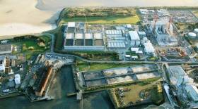
Europe’s largest phosphorus extraction reactor has been installed at the Ringsend wastewater treatment plant in Dublin, as RTÉ News reports.
Úisce Éireann (formerly Irish Water) says the reactor — which is extracting phosphorous to be turned into agricultural fertiliser — will help protect water quality in the lower River Liffey and Dublin Bay which have experienced potentially harmful algal blooms in recent years.
The new addition is part of a €500 million upgrade works at the Ringsend facility, which treats 40% of all sewage generated in Ireland — well beyond its capacity.
RTÉ News has much more on the story HERE.
Waterways Ireland Issues Warning Over Blue-Green Algal Blooms
Waterways Ireland says it’s been notified of the presence of blue-green algae in a number of locations on the inland waterways.
Blue-green algae are toxic to humans and potentially lethal to animals.
The cross-border body for Ireland’s inland waterways asks boaters to comply with the notices placed by local authorities and avoid contact or immersive activities in areas where blue-green algae are present.
Waterways Ireland jetties and slipways remain open, but the agency advises boaters and other users to stay out of the water.
It also asks for the public to report any encounters with blue-green algal blooms to the relevant local authority.
Waterways Ireland Issues Warning Over Algal Bloom on Shannon Navigation
Waterways Ireland advises users of the Shannon Navigation that a number of locations throughout the Shannon, in particular harbours and bays, have experienced or are likely to experience algal blooms.
This seasonal phenomenon is evident as a light pea-green and/or green, blue or blue-green colour in the water column on or near the water’s surface.
Information from the HSE’s Interim Fresh Water Algal Bloom Guidance is as follows:
- Affected waters may contain high levels of blue-green algae which may cause illness in humans and animals including pets.
- Avoid contact with scum, visible algae and surrounding water.
- Do not swim or partake in immersive watersport activities in water near visible algae.
- Do not touch scum on the shore.
- Wash hands if you touch the algal material.
- Keep children and pets away from the water’s edge.
- Do not let pets drink the water.
- Wash pets if they come into contact with water.
How Harmful Algal Blooms Impact the Coastal Seas of Europe
Over the last three years, researchers from 12 institutes across seven European countries (Norway, Sweden, Germany, Ireland, France, Spain and Romania) investigated the impacts of ocean climate change on coastal marine ecosystems.
The researchers, with expertise in climate change, social science, economics, modelling, marine biology, chemistry and physics were partners in the CoCliME project. The central purpose of the CoCliME (Co-development of Climate Services for adaptation to changing Marine Ecosystems) project was to create climate adaptation services in partnership with representatives from marine-related businesses, regional authorities and coastal communities who are directly impacted by Harmful Algal Bloom events. The harmful microscopic plankton, come in many shapes and sizes, and cause issues for shellfish harvesting, fish farming, fisheries, tourism and human health.
Dr Caroline Cusack of the Marine Institute said, “Ocean climate-driven changes in Harmful Algal Bloom (HAB) distributions and abundances will continue to directly impact marine related businesses and coastal communities. Working closely with those affected by blooms, the CoCliME partners tailored a number of useful services in the areas of decision support, training and outreach.”
CoCliME decision-support services
CoCliME economists developed a shellfish trade ban database in France with future government plans to extend it nationwide. The database is used to investigate shellfish production closures, and determine the potential economic impacts closures may have on the local shellfish industry. Harmful Algal Blooms represent 90% of motives for closing the farming zones. The effects can last over several weeks to several months and occur almost yearly with some shellfish areas impacted several times a year.
In 2019, after an exceptional harmful algal bloom that resulted in massive amount of farmed salmon mortalities in Norway, CoCliME researchers developed a new HAB monitoring programme with the Norwegian Food Safety Authority, the Norwegian Directorate of Fisheries, and mussel/fish farmers and together they are continuing the work to develop a ‘one-stop-shop’ website for the aquaculture industry.
In the Mediterranean, CoCliME researchers worked closely with water and health agency representatives to coordinate a monitoring programme to identify harmful Ostreopsis bloom events in summer as aerosolised chemicals from these blooms can cause mild respiratory irritations in beach users. Researchers connected to the Ramoge Agreement (France, Monaco and Italy) and from Spain participated in CoCliME and monitored increases of Ostreopsis blooms in the Mediterranean and Atlantic, which is helping public authorities and private stakeholders to better identify bloom impacts.
“It contributes to increasing awareness on climate ocean and human health. They shed light on influences of climate change on the development of HABs and the social and economic aspects as well as the health component that they induce in a coastal area such as the Mediterranean, which is particularly touristy,” said Anne Vissio, Secrétaire executive, Accord RAMOGE.
There are now plans to continue the coordination of a HAB alert service. In Sweden, ocean climate models developed in CoCliME provided useful information on what the future cyanobacteria bloom risks are as the climate changes.
“CoCliME gave me new insights into the harmfulness of different phytoplankton taxa and the forcing factors of bloom formation. The projected climate change effects on cyanobacteria blooms in the Baltic Sea is useful information for me,” said Malin Persson of the Swedish National Food Agency.
CoCliME training courses
Other activities in the CoCliME project, led by German, Spanish and French researchers included training courses on novel molecular biology detection techniques, how to sample HABs that live on seaweed and statistical training courses focused on long time series analyses and model projections.
Dave Clarke, Shellfish Safety Manager at the Marine Institute Ireland, who attended one of CoCliME training workshops said, “Molecular methods offer reliable detection to enable industry and regulatory authorities to make informed risk management decisions. To have courses like this is extremely beneficial and valuable where laboratory personnel can be trained and learn new molecular techniques that assist in their daily statutory monitoring and research activities.”
“The hands on qPCR course allowed me to gain a comprehensive understanding of new tools for the detection of HAB species in Europe” said Laia Viure, who conducts monitoring of Ostreopsis cf ovata in the Catalan coast.
CoCliME Outreach
Today, scientists have an important role in translating technical scientific jargon into a language that users can understand. In the CoCliME project, many users requested accessible information on the impacts of climate change on the ocean and harmful algal blooms for a wide audience including policy makers, general public, local and regional authorities and medical professionals. With this in mind, CoCliME researchers developed infographics and illustrations to inform and build awareness on the importance of our ocean, the changes that are occurring and the potential impacts on ecosystems and human communities. Post project plans include the use of the graphics, translated into relevant languages, for use in brochures, websites, training courses and other publication materials.
David Mellett, Irish Climate Action Regional Office, Atlantic Seaboard North Coordinator stated, “Local authorities are on the front line of climate change and climate adaptation because the physical effects of climate change manifest locally through incidents of flooding, coastal erosion or other extreme weather events and our measure of climate risks needs to be understood in the context of geographically defined areas. All local authorities have adopted Climate Adaptation Strategies and are working towards adapting their functions and supporting communities build resilience and plan for the impacts of climate change. Coastal zones are especially in need of climate services for adaptation, as they are increasingly threatened by sea level rise and its impacts, such as submergence, flooding, shoreline erosion, salinization and wetland change. The climate services for adaptation to our changing marine ecosystems developed under the CoCliME project will help build awareness of the importance of our oceans, better understand the risks and opportunities for coastal communities and inform decision making into the future. The ocean climate infographics already developed under the project is a clear example of how scientific information can be communicated to a broad audience to help build awareness of the role of our oceans in regulating climate change and the increasing risks and opportunities to the cultural and economics of coastal communities.”
The CoCliME (Co-development of Climate Services for adaptation to changing Marine Ecosystems) Project, was coordinated by the Marine Institute and funded by the Irish Environmental Protection Agency (EPA), the European Commission and other European national funders.
Wastewater Overflows In Dublin Bay ‘Make Algal Blooms More Likely’
Wastewater overflows from Ringsend’s over-capacity treatment plant have made algal blooms in Dublin Bay much more likely, says one marine expert.
Speaking to The Green News, Karin Dubsky of Coastwatch Ireland said overflows from Ringsend which have occurred after heavy rainfalls provide the right nutrient-rich environment for algae to prosper.
Afloat.ie readers will remember the ‘orange slick’ seen on south Dublin beaches this past summer — and this past week the Shelly Banks adjacent to the Ringsend plant was blanketed in rotting seaweed many mistook for raw sewage.
But capacity issues at Ringsend are only one facet of the the problem, according to Dubsky.
“It’s not just one big Ringsend discharge as the treatment plant is struggling, it’s all those smaller stormwater overflows mixed with sewage water which are discharging right at high watermark onto the shore,” she said.
The Green News has more on the story HERE.
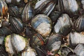
It’s understood that hundreds if not thousands of fish including brown trout, juvenile salmon and bream may be affected by a fish kill on a tributary of the Bandon River in Co Cork.
Inland Fisheries Ireland (IFI) says it is investigating the fish kill on a minor tributary of the Bandon River in Co Cork in the stream south of Dunmanway near Curraghalicky Lake.
IFI says it attended the site on Monday evening (26 August) following a report from a local angler — and initial investigations point to “a significant algal bloom” as the cause.
“Efforts are ongoing to assess the extent of the fish kill and an aerial survey of the lake is underway,” IFI adds.
“Cork County Council has taken water samples from the lake and river and is liaising with Inland Fisheries Ireland in their investigation.”
World’s Most Advanced Ship For Monitoring Harmful Algae Completes Survey Of Irish Waters
#MarineScience - Blooms of toxin-producing algae and unprecedented levels of microplastic particles were detected in a recent oceanic survey carried out by scientists from the Marine Institute.
Bristling with sensors and state-of-the-art technology, the German research vessel RS Heincke completed a circumnavigation of UK and Ireland this August in a month-long survey.
A team of six Irish phytoplankton, biotoxin and oceanographic scientists joined the survey, which was conducted by the Alfred Wegener Institute Helmholtz Centre for Polar and Marine Research in collaboration with the Marine Institute and the University of Oldenburg Institute for Chemistry and Biology of the Marine Environment.
A total of 75 stations were surveyed using instrumentation aboard the ship, which was primarily designed to investigate Azaspiracid toxins produced by a number of micro-planktonic species of the family Amphidomataceae.
“This research is important for us as Ireland remains the most affected country in the world by shellfish poisonings caused by toxins produced by these species,” said Joe Silke, senior scientist on the survey from the Marine Institute.
These toxins, which were first discovered 23 years ago during routine monitoring of Irish shellfish, have resulted in annual temporary closures of Irish shellfish production areas, with resulting economic loss from loss of sales and markets.
Recent research has identified that the Amphidomataceae, unlike many other toxic algae, are pelagic plankton found in the open sea to the west of Ireland. These can accumulate in specific cases of currents and wind direction, creating toxin problems in the shellfish production bays along the West coast.
This was the first time that near real-time analysis was possible underway due to the advanced equipment available for the survey, including a fully equipped chemistry lab capable of measuring and identifying trace levels of toxin produced by the plankton using a liquid chromatography mass spectrometry instrument. Only 30 minutes after taking plankton samples aboard a full characterisation of the toxins present was possible with this equipment.
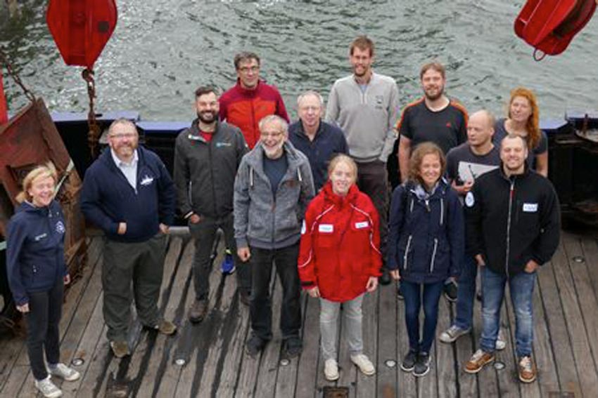 Irish and German scientists aboard the RS Heincke for the HE516 phytoplankton survey of the North Sea, English Channel and Atlantic Shelf | Photo: Marine Institute
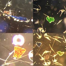
The team of scientists on board were able to confirm the presence of these phytoplankton at several offshore and nearshore stations, and collected an integrated data set comprising oceanographic, bio-optical, meteorological, plankton and sediment data accompanied by taxonomic determinations, toxin measurements and DNA analysis.
“Having the capability to carry out near real-time analysis of microscopic plankton while at sea to reveal the species present and their toxins is a huge leap forward in opportunities for our research programmes,” Silke said.
Simultaneous research activities included taxonomic analyses of the filtered plankton. Scientists used high resolution microscopy, further supported by real-time analyses of the plankton using molecular biological technology designed to recognise the DNA fingerprint of individual species.
Automated instruments on board such as a FerryBox carried out physico-chemical analysis of underway water, and a Flow-Cam carried out automated particle measurements and image analysis of phytoplankton samples. Full bio-optical properties of the water were measured using instruments on the ship measuring spectral properties both above and in the water.
In the course of the survey, several other blooms of algae were detected along the oceanographic fronts traversed by the ship’s track. These included large blooms of the usual late summer phytoplankton that we commonly see in coastal waters. These comprised mostly diatoms and dinoflagellates, such as Dinophysis acuta that produce DSP shellfish toxins, and Karenia mikimotoi that can cause fish and invertebrate mortalities if it accumulates in coastal areas.
The survey also revealed several species of Azadinium, the target group for this survey. These included some rare species, and some that have not been recorded previously in Irish waters.
One unexpected observation in the plankton net hauls was the diverse and frequent observation of microplastic particles in the same size range as the phytoplankton. While the survey was not looking for these in particular, it was evident that their occurrence is more widespread than observed in previous surveys in offshore waters, and would also appear to be diverse in nature based on shape and colour.
The European Food Safety Authority stated recently that plastic particles of this nature are less likely to pass to humans through fish, because the they do not pass through the intestine into other tissues of finfish, and the digestive tract is normally discarded. They may, however, pass to the food chain through filter-feeding shellfish species where the GI tract is consumed.
The sizes of particles observed on this survey would lend support to this, although the risk of exposure to humans and its consequence on health requires more research.
Marine Institute Leads New Project In Predicting Shellfish Safety
#Shellfish - Predicting risk and impact of harmful algal bloom events that cause impact to the shellfish aquaculture sector (PRIMROSE) is a new €2.7-million marine science project led by the Marine Institute.
The project is funded by the Interreg Atlantic Area Operational Programme and includes 10 research and SME partners from five countries along the Atlantic Arc from southern Spain to the Shetland Islands.
During the next three years, the PRIMROSE project will form a network of scientists and industry members to produce an inter-regional toxin and microbiological advisory and forecasting capability to the European aquaculture industry.
“The project will produce applications based on reusing existing monitoring data, modelled coastal hydrodynamics, satellite and other novel aerial observations, meteorological, historical and recent trend data to predict and give early warning of toxic blooms and elevated microbiological events,” said project coordinator Joe Silke, from the Marine Institute.
“This will allow fish and shellfish farmers to adapt their culture and harvesting practices in time, in order to reduce potential losses.”
The Marine Institute will implement the lead role of co-ordinating the project and ensure that all the work packages, actions, deliverables and results are achieved.
Already a strong partnership approach has been established during the project preparation. By consolidating and further developing the regional knowledge capital that exists, the consortium is confident of a successful outcome.
Partners will participate in a suite of six work packages and will develop a sustainable product that will be largely automated to predict and produce regular published reports for the long term once the project is finished.
In recent years, there has been much discussion of satellites being able to track surface algal blooms. Understanding biological phenomena in the ocean requires a complex approach, though there is some merit in using satellite derived chlorophyll images to delineate high biomass near surface algal blooms.
Much cutting edge harmful algal bloom research work has focused on subsurface profiles, where certain species are present in thin layers of limited geographical extent often associated with strong density interfaces. Phytoplankton blooms, micro-algal blooms, toxic algae, red tides, or harmful algae, are all terms for naturally occurring phenomena.
Clearly, in order for a toxic, harmful algal bloom, or a microbiological forecast to be realistic, physical factors including changes in water column structure and transport pathways are necessary.
“PRIMROSE is the next step towards providing an operational advisory service by integrating physical oceanographic drivers with a variety of biotoxin, phytoplankton count and microbiological data,” said Silke. “A distributed advisory service and a network of thematic experts distributed across the participating countries will then network to provide regular advisory products and forecasts of impending toxic and harmful algal events.”
PRIMROSE brings together experts in the areas of modelling, Earth observation, harmful algal bloom and microbiological monitoring programmes and end users to assemble a number of key data sets and build upon and explore new forecasting options.
The consortium includes three UK partners (Seafood Shetland, Scottish Association for Marine Science and Plymouth Marine Lab) two Irish partners (Marine Institute and Bantry Marine Research Station), one partner in France (IFREMER), three in Spain (AZTI, Instituto Oceanographico Espanol and AGAPA) and one in Portugal (Institute Technico Superior/University of Lisboa).
The Marine Institute recently issued a recruitment call for a data analyst and project co-ordinator for the PRIMROSE project, as previously reported on Afloat.ie.
Algal Bloom On East Coast Beaches Under Observation
#AlgalBloom - The Marine Institute says it is currently monitoring an algal bloom on beaches on the east coast of Ireland as a part of its Phytoplankton Monitoring programme.
The bloom was detected two weeks ago using satellite images and information provided by the Environmental Protection Agency (EPA) and Wexford County Council.
The Marine Institute has analysed a number of samples from the algal bloom and has identified the species as Phaeocystis pouchetii, a common species that has caused blooms along the east coast several times in previous years. The species causes discolouration of the water, and foaming on the beach in windy conditions.
Joe Silke of marine environment and food safety services at the Marine Institute emphasised that the species is not directly harmful to humans either through swimming or from consuming fish that have been exposed to the bloom.
Beaches remain safe despite any discolouration of water, though the production of foam, and in some extreme cases anoxia, can result in marine organism mortalities.
However, unlike last summer's destructive algal bloom on the west and north coasts that was responsible for significant fish and shellfish kills from Galway to Donegal, fish mortalities caused by this particular species in previous Irish blooms have not been observed, as wild fish tend to avoid the bloom. This may explain the low catches reported by sea anglers on the east coast in recent weeks.
Several fishermen have also reported clogging of nets in recent weeks, which may be caused by the decaying bloom sinking to the seafloor.
Algal blooms are commonly detected over the summer months in coastal areas. It is likely that this particular bloom will dissipate in in the next week or so and will be replaced with the normal succession of microalgae that form the bottom of the food chain in the sea.
Algal Bloom Subsides off North Coast of Ireland

#algalbloom – After impacting on the marine wildlife along the north west coast for the past month, the algal bloom of Karenia mikimotoi has finally began to subside. The bloom severely affected areas of the North West from Mayo to Donegal and in certain areas down along the rest of the West coast. It impacted on coastal marine life in these areas and resulted in considerable mortalities of fish, shellfish and other coastal invertebrates. The most recent satellite imagery and seawater samples analysed by the Marine Institute show a significant decrease in the concentration compared to recent weeks.
Mr Joe Silke of the Marine Institute stated, "These blooms are part of the natural summer marine flora, and occasionally they form these exceptionally high blooms. Karenia mikimotoi is a common species in all European waters and dense bloom have been detected many times in the past. This recent bloom is similar in impact and duration to one which we experienced in 2005, and is most likely due to a combination of environmental conditions and ocean currents providing optimal conditions on the continental shelf. The accumulation of the bloom against the coastline with tidal and coastal currents causes very dense concentrations to occur. Mortalities in marine organisms particularly those living on or near the bottom are due to the algae affecting their respiratory systems and this is compounded by low oxygen in the water, particularly as the bloom is decaying."
While the bloom of this species is not known to harm humans directly, dead marine life was washed up on the shoreline, even requiring Local Authorities to temporarily close two beaches in Donegal. Discoloured reddish - brown water were observed along large expanses of the coast line. In several areas, oyster farms reported losses between 20 to 80% in some sites and farms stocking juvenile oysters also reported significant mortalities with many deciding to defer putting out new stock until the bloom passes. Other areas affected included Galway Bay, and while no mortalities were reported in this region, a shellfish hatchery in the area reported difficulty in settlement of their shellfish larvae. Local sea anglers have reported low fish catches along west and northern coasts and in some areas a complete absence of any fish. This is mainly due to fish avoiding the bloom when they can. Lobster and Prawn fishermen have also reported very poor catches in the Donegal area.
Indications from satellite and modelled data last week showed the bloom was moving back out to sea, and the latest cell counts of samples analysed in the Marine Institute today show that the bloom is has reduced significantly in the west Donegal and Sligo regions as it was last week, but it is still present Galway Bay. The Marine Institute's monitoring programme will continue to sample and monitor the bloom and post updates on our website at marine.ie and on local radio.


, marking also a first presence in this market.")


 Michael Murphy Schull Harbour Sailing Club (SHSC), Eric Coogan Heineken Ireland, Mark Murphy, Commodore SHSC, Jack Allen SHSC, Carmel O'Regan SHSC, Cornelious Ndlovu, Schull Harbour Hotel Operations Manager and Derval Murphy SHSC")

