


Displaying items by tag: satellite
Satellite Rocket Launch Prompts Call for Vigilance by Mariners Off Ireland’s South West Next Week
Ireland’s first Marine Notice of 2023 is out of this world — quite literally, as it advises of potential hazard at sea from a satellite rocket launch from Cornwall next week.
Virgin Orbit has designated a space launch hazard area off the South West Coast active from 10pm on Monday 9 to 1am on Tuesday 10 January, subject to weather and operational constraints.
Where the launch attempt proceeds as planned, no debris will enter this area. However, there is a low probability for the vehicle to produce dangerous debris if a mishap were to occur, Virgin Orbit says.
Mariners are advised to avoid the marine hazard area during and leading up to the launch period due to possible dangerous conditions from potential rocket debris.
More precise details of the launch will be promulgated though the MSI service by the Irish Coast Guard and UK;s HM Coastguard on VHF, MF and NAVTEX broadcasts, five days before the launch.
Virgin Orbit says it will be taking every step possible to monitor the area during the launch attempt. Mariners are advised to report any debris or pollution sightings in the event of a launch mishap.
Backup launch dates as well as relevant coordinates, a map and contact details can be found in Marine Notice No 1 of 2023, attached below.
New Tech Puts 'Eyes On The Seas' To Curb Fishing Pirates
#Fishing - Who's watching out for illegal fishing in the world's oceans? It could be anyone at the click of a mouse of the tap of a touchscreen – if a new satellite tracking programme takes off.
NPR's The Salt blog reports on the Eyes on the Seas project, that aims to help authorities the world over keep tabs on illegal fishing activity via a 'virtual watch room' that combines satellite imagery with real-time location data.
The inspiration for the project is the recently launched Global Fishing Watch system. As reported on Afloat.ie last November, this uses specialised software from a small start-up called SkyTruth, which maps AIS data onto satellite maps of the oceans to track the activity of fishing fleets around the world.
The project has the backing of internet giant Google, and now SkyTruth's John Amos has partnered with the Pew Charitable Trusts on the latest version of the initiative to use technology against the ocean's seafood pirates.
NPR has much more on the story HERE.
Irish Marine Innovations Applauded By Euro Space Agency
#MarineScience - Irish companies and researchers have distinguished themselves by developing innovative maritime services using satellite derived data in areas as diverse as marine renewables, fisheries protection, aquaculture and tourism.
That was the message from Dr Volker Liebig, director of Earth observation programmes with the European Space Agency at the opening of a conference on 'Space Innovation - Powering Blue Growth' at the National Maritime College of Ireland in Cork last week.
Minister for Research and Innovation Sean Sherlock, who opened the two-day event, said: “There are over 40 Irish companies currently engaged in ESA programmes, many of which are directly addressing global challenges such as climate change, sea-level rise, maritime surveillance and marine environmental monitoring.
"This is a growing industry and one which will guarantee high-quality jobs for Irish people and benefit our economy into the future.”
The conference - jointly organised by the ESA, the European Commission (DG Maritime Affairs), Enterprise Ireland, University College Cork’s Coastal and Marine Research Centre, the Irish Coast Guard and the Irish Naval Service - focussed on the contribution of space to maritime policy implementation; showed how new scientific results and innovative services assist in achieving targets set by the Integrated Maritime Policy for the European Union (IMP); and assessed how the ESA space development activities and the IMP can contribute to economic growth in Europe.
Geoffrey O’Sullivan, representing Marine Institute CEO Dr Peter Heffernan, said that the conference "ably demonstrated that Space Remote Sensing had a very positive contribution to make towards developing our blue economy.”
Examples given included fisheries management (including illegal, unreported and unregulated fishing); environmental assessment; detection of oil spills and harmful algal blooms; site survey for offshore renewable energy and aquaculture platforms; search and rescue; and maritime domain awareness (MDA).
O'Sullivan added that the Conference "validated the SMARTOCEAN (ICT and the Sea) Strategy being promoted by the Marine Institute, in identifying clear opportunities for Irish researchers and SMEs to harness their significant ICT and marine research skills and drawing on 'Big Data' provided by satellite sensors to develop of range of new products, services and applications relevant to local and global markets.”
Closing the conference, Marine Minister Simon Coveney commented that “increasing maritime situational and domain awareness is paramount in promoting a more inclusive approach to maritime development in delivering both the EU Blue Growth Strategy (2012) and Ireland’s Integrated Marine Plan (Harnessing Our Ocean Wealth) launched in 2012.
"Space based systems,” he said, “are a key component of an integrated and sophisticated maritime surveillance network.”
Irish Coast Guard Collaborates On New Marine Monitoring System
#Coastguard - The Irish Coast Guard is collaborating on a new system of marine monitoring in the hopes of detecting a dead ship that may threaten to run aground on Ireland's shores.
The Newfoundland Shipping News blog details how the MV Lyubov Orlova, adrift somewhere in the North Atlantic, is being used to test the capabilities of a new system called Global Maritime Awareness.
The system is based on the idea that if the world's top satellite tracking technologies could be banded together, it could establish a much more comprehensive monitoring system for the marine environment.
Marine surveillance expert Guy Thomas, who devised the concept, said he had the idea that if a receiver akin to that used in the Automatic Identification System (AIS) for ship tracking and collision avoidance was put on a satellite in orbit, "you would now have the international identification system for ships that was lacking".
That was done, and a second accompanying system was added that provides radar information from space. The Global Maritime Awareness system combines those with detailed satellite imagery, and Long Range Identification and Tracking {LRIT) technology whereby ships can verify themselves to others and the systems tracking them.
Thomas says these four satellite systems working in tandem make for "a very effective tool in monitoring marine environments for illegal activity".
But it can also be used to prevent potential environmental catastrophes - which is where the MV Lyubov Orlova comes in.
The Irish Coast Guard's director Chris Reynolds contacted Thomas with its concerns that the dead ship might drift into Irish waters and become a burden on the State. Thomas suggested using his system to find it, almost like an ocean-wide version of the game Battleships: even when a ship isn't sending any signals, it can still be tracked, just by looking for ships that aren't transcending through AIS.
Thomas and the Irish Coast Guard are currently working hard at this, crossing off vessels that are communicating through satellite systems till they can narrow it down to the one they're looking for. And they may now have a hit south-southeast of Greenland, although it will be some days before they can confirm.
Newfoundland Shipping News has much more on the story HERE.
While it might be an exaggeration to say that all of the 21 crew members of Rambler 100 owe their lives to the Irish Search and Rescue service, there are certainly five people whose future prospects were greatly improved by the operation off the Fastnet Rock on August 15th. A lot of media focus has been on Coxswain Kieran Cotter and the crew of Baltimore Lifeboat as well as lifeboat mechanic Jerry Smith, whose dive boat, on charter to the media team of one of the competitors, was on hand to search and recover the five drifting crew. There is no question that this focus is appropriate. RNLI crews all over the UK and Ireland deserve the attention, not only because of their extraordinary voluntary dedication to the cause, but also because such publicity helps swell the coffers of the charity. The service could not operate without the generosity of the donors and incidents such as these help fill the blue boat-shaped boxes held by even more RNLI volunteers.
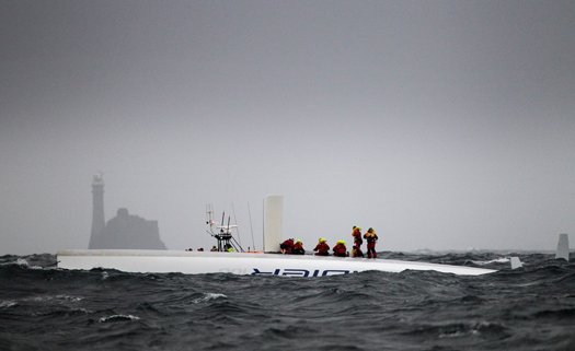
Saved: Ireland's Rescue Services Answered the Call of the capsized Supermaxi Rambler 100 off the Fastnet Rock. Photo: Team Phaedo
The dramatic stories and pictures dominating the media show the front line of a quite wonderful resource that is Search and Rescue in Ireland today. Baltimore Lifeboat was at the coal face of an intricate network of operations, triggered by the crew's EPIRBs. Irish Coast Guard radio officers in Valentia responded almost immediately tasking the rescue resources, working the phones and computers to confirm that this was not an accidentally triggered EPIRB, contacting RORC HQ, determining search patterns and relaying the information to the scene. It was the backroom contacts between RORC and the Coast Guard in endeavouring to contact Rambler 100 using satellite phones that confirmed the possibility of a catastrophic incident involving the Supermaxi. The subsequent tasking of the Shannon and Waterford based Sikorsky helicopters led to the medevac of crew member Wendy Touton and timely treatment of her hypothermic condition, initially by the on-board paramedics and later at Tralee General hospital. And Coast Guard involvement didn't end with the successful rescue – the shoreside operation to provide food and shelter in Baltimore was coordinated by Coast Guard personnel and the salvage operation of the hull of Rambler 100 was overseen by the Irish Coast Guard.
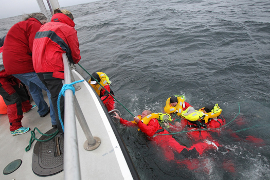
Rambler crew are recovered from the water after a SAR operation by the Irish Coastguard Photo: Team Phaedo. More photos here.
That Ireland has probably one of the best Search and Rescue services in the world goes back to the campaign initiated in 1988 by Joan McGinley, following the death, within sight of land of Donegal fisherman John Oglesby, whose leg was severed in a trawl winch. Eamon Doherty, the late former Garda Commissioner chaired the review group established in response to the campaign and his report led to the establishment of the Irish Marine Emergency Service, subsequently the Irish Coast Guard. Under the guidance of Director Capt Liam Kirwan, the new service moved quickly to become not only the central co-ordinating body for Search and Rescue, but developed its own resources, notably the helicopters, previously tasked in from Irish Air Corps and UK SAR.
Another element that will feature in the Rambler 100 incident is the Marine Casualty Investigation Board (MCIB), set up from recommendations arising from a review of the handling of investigations into marine casualties.
It might be thought that the incident is now closed, but there are many unanswered questions and the investigation will be looking at these and making recommendations that should improve safety in this sector. These questions will include EPIRB performance, liferaft deployment and grab bag usage, but perhaps the key issue yet to be determined is why the response from fellow competitors didn't appear to happen. Even if Channel 16 wasn't being actively monitored, and if not why not, shouldn't the Mayday set off by the Coast Guard have set off the DSC alerts on the radios of Rambler 100's fellow competitors? Had the incident occurred several hours later or earlier when Rambler 100 could have been up to 100 miles from the nearest land, when conditions worsened, we could be looking at much more serious consequences.
It is heartening to think that, in this small country of ours in troubled times, not only do we have a shining star in our search, rescue, recovery and restore system, involving professionals and volunteers cooperating for the greater good, we also have a system that determines the nature of incidents so that we can all learn from the experience.
And let us not forget those people and services, such as the Gardai, Navy, Army and the community of Baltimore who are outside the media spotlight who contributed to this happy ending.
Afloat's Latest Coastguard News
Afloat's Latest RNLI Lifeboat News
Afloat's Latest MCIB News


 as lead helm, rounds the Fastnet Rock on the way to the overall win in 1987")


 Michael Murphy Schull Harbour Sailing Club (SHSC), Eric Coogan Heineken Ireland, Mark Murphy, Commodore SHSC, Jack Allen SHSC, Carmel O'Regan SHSC, Cornelious Ndlovu, Schull Harbour Hotel Operations Manager and Derval Murphy SHSC")
