


Displaying items by tag: Marine Notice
Brussels Issues Brexit Preparedness Notice On Maritime Security

#Brexit - The latest notice from the European Commission to stakeholders on Brexit preparedness concerns the field of aviation and maritime security.
Subject to any transitional arrangement that may be contained in a possible withdrawal agreement, as of the withdrawal date, the EU rules in the field of aviation security and maritime security will no longer apply to the United Kingdom.
In the maritime context, this will have consequences with regard to mandatory security information for passenger ferry services in the EU, from which the UK is exempt as a member state, and security inspections of vessels which the UK will no longer be able to carry out.
To date the Department of Transport, Tourism and Sport has published five Brexit preparedness notices relevant to maritime transport.
Full details of preparedness advice for maritime security are included in Marine Notice No 37 of 2018, a PDF of which is available to read or download HERE.
Marine Notice: Survey Operations For Subsea Cable In Irish Sea
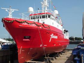
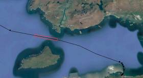
#MarineNotice - Fugro is currently carrying out marine operations in the Irish Sea on behalf of Alcatel Submarine Networks for the Havhingsten Subsea Cable System project.
The works from Loughshinny in North Co Dublin on an east-northeasterly route were scheduled to commence yesterday (Wednesday 26 September) and will last for around 30 days.
The vessel involved is the MV Fugro Helmert (Callsign: ZDNM8), which is running hull-mounted multibeam echo sounder lines along the proposed route.
Towing equipment such as magnetometer and side-scan sonar will be used during the shallow water phase, from around 105m of water depth and shallower.
The vessel will slow down or stop from time to time to measure the speed of sound in the water, and to perform geotechnical measurements.
A dynamic programme of survey is to be conducted in several stages. The survey vessel will be deployed within the working area at times and positions determined by client requirements, weather and sea conditions.
Inshore survey operations will be conducted on a 12-hour basis (daylight). Offshore survey operations will be conducted on a 24-hour basis.
Throughout the offshore survey, the vessel will be displaying shapes and lights prescribed in the International Rules for the Prevention of Collisions at Sea (COLREGS) Rule 27 to indicate that the survey vessels are restricted in their ability to manoeuvre.
A listening watch will be maintained on VHF Channel 16, and the vessels will actively transmit an AIS signal.
Details of co-ordinates are included in Marine Notice 35 of 2018, a PDF of which is available to read or download HERE.
European Commission Urges Preparedness For Brexit In Maritime Sector
#Brexit - The latest Marine Notice from the Department of Transport, Tourism & Sport (DTTAS) sets out the European Commission’s recommended actions for Brexit preparedness for all stakeholders that may be affected by the UK’s withdrawal from the European Union next year.
Examples of necessary legislative changes at an EU level are indicated in the communication attached to Marine Notice No 34 of 2018. Some of these relate to the maritime sector.
The DTTAS also draws attention to other technical notices published by the European Commission, which set out the legal and practical implications of a no-deal Brexit. The department has published four of these notices relevant to maritime transport:
- Notice to Stakeholders in the Field of Industrial Products
- Notice to Stakeholders on Seafarers Certificates
- Notice to Stakeholders in the Field of Maritime Transport
- Notice to Stakeholders – EU Ship Recycling Regulation
The relevant notices were attached to Marine Notice No 7 of 2018 and Marine Notice No 23 of 2018.
Full details of all previous stakeholder notices are available from the European Commission website.
#Harbours - Works on the €23.5 million quay extension at Castletownbere Fishery Harbour Centre are due to begin by September.
As previously reported on Afloat.ie, Marine Minister Michael Creed attended the signing of the contract for the 216-metre Dinish Wharf extension with L&M Keating Ltd, after the project was green-lit this past May.
The works are being advanced by civil engineering crews working both from the adjacent lands, existing harbour infrastructure, and from jack-up barges, pontoons, heavy civil engineering plant and machinery, work vessels and platforms. Divers will also be also employed on site.
For safety reasons, mariners are advised to proceed slowly and with caution in the approach channel to the inner harbour, and within the inner harbour area, and to give the
works a clear berth. Wave wash from vessels should be avoided.
According to Marine Notice No 33 of 2018, these works are expected to continue till March 2020 and include, but are not limited to:
- Construction of a new quay structure approximately 216m at Dinish Island, including all associated infilling and land reclamation.
- Dredging of a berthing pocket adjacent to the new wharf extension by dredging to a depth of -8.0m Chart Datum.
- Dredging of a navigation channel to a depth of -6.5m Chart Datum.
- Construction of two new breakwater structures.
- Construction of a reclamation area to act as a quay/storage hinterland area.
- Provision of all water, electrical and fuels services.
- Heavy-duty pavement surfacing to new wharf/quay structure area
- Ancillary marine facilities and services.
- Relocation of navigation lights.
- Revised security and access arrangements for quay facilities.
#MarineNotice - Shell E&P Ireland Limited has begun a campaign of inspection of the Corrib Gas Field pipeline and associated infrastructure with repair and maintenance as required. Engineering tasks are also scheduled for well P3.
The near shore pipeline inspection was scheduled to commence in mid July and last for approximately 10 days. The offshore pipeline and subsea structure inspection along with the P3 work is due to commence in early August 2018 and last for approximately 14 days.
Visual and acoustic surveys will be conducted by means of sensors mounted on vessels and Remote Operated Vehicles (ROV) and cameras located on attendant survey vessels, ROVs and towed side scan sonar.
The near shore pipeline and umbilical sections will be inspected from the nearest point accessible inshore at high tide progressing to offshore until a suitable overlap with the offshore inspection is achieved.
The offshore inspection will commence at the Corrib field location and will continue towards shore until the vessel is required, on Marine Mammal Observer (MMO) advice, to relocate to the inshore inspection extent at safe navigation depth limit.
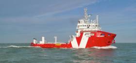
The vessel An Gearoidin (Callsign EIDL6) will undertake the near shore survey scope. All the equipment used will be vessel deployed. The Macbel and Blue Eagle will provide safety and welfare support to An Gearoidin.
The Siem Stingray (Callsign LAFP8) will undertake the deep water surveys and the subsea facilities maintenance and inspection. It will also carry out the P3 rectification work. All equipment used will be vessel and/or ROV mounted. All vessels will be listening on VHF Channel 16 throughout the project.
Full details of relevant co-ordinates and a map of the survey area are included in Marine Notice No 31 of 2018, a PDF of which is available to read or download HERE.
Marine Notice: Extended Cable Route Survey Off West Coast
#MarineNotice - Fugro will be carrying out further marine operations on behalf of TE Subsea Communications LLC for the HAVFRUE Subsea Cable System Project south of Achill Island from this week.
The operations are an extension of the project outlined in Marine Notice No 22 of 2018 and are scheduled to be carried out between Saturday 13 July and Saturday 17 August, to last for approximately one day weather permitting.
Works will be undertaken by the RHIB Diversity (Callsign: EI-SV-7), which will be towing equipment such as a magnetometer and a side scan sonar to be used during the shallow water phase, from 50m of water depth and shallower.
Survey operations will be conducted on a 24-hour basis. The vessel will display shapes and lights prescribed in the International Rules for the Prevention of Collisions at Sea (COLREGS) Rule 27, to indicate that the survey vessel is restricted in its ability to manoeuvre. A listening watch will be maintained on VHF Channel 16.
Details of the location of the project are outlined in Marine Notice No 29 of 2018, a PDF of which is available to read or download HERE.
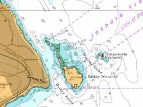
#MarineNotice - Mariners are advised that a Port Lateral Mark has been deployed marking Leac Buidhe Rock, north of Dalkey Island.
The buoy has the following light characteristic Fl(4)R.6s, and will be seasonally deployed from April to October. It can be found at position 53°16.650’N 006°05.100’W.
Afloat.ie understands that the mark placement has been made at the suggestion of Dublin Bay Sailing Club, after a number of incidents in which boats have been damaged by contact with Leac Buidhe Rock.
In 2015, Winter DBSC Turkey Shoot organiser Fintan Cairns issued a warning to competitors to look out for the rock that had caused problems for competitors. See the warning to competitors and a photo of Leac Buidhe here.
While welcoming the new buoy, Cairns also says 'unfortunately it will only be marked for summer months so we will have to be careful during winter'.
Seaweed Harvesting Begins In Bantry Bay

Mechanical harvesting of sub-tidal seaweed was set to begin today (Wednesday 4 July) in Bantry Bay.
Operations by BioAtlantis Aquamarine Ltd, using the Atlantis Explorer (Callsugn EIPQ2) are expected to continue for the duration of the licence until 2024. Harvesting will take place in Areas A, B, C, D and E of the licence area, details of which are included in Marine Notice No 29 of 2018, available to read or download HERE.
The harvesting operations are proceeding despite a High Court challenge to the project by a number of environmental groups, according to The Irish Times.
The High Court has granted a judicial review of the licence awarded in November last year, and opposed by the Bantry Bay - Save Our Kelp Forests group, among others, for its alleged potential to “irreversible damage to the ecosystem and businesses of the Bantry Bay area”.
The Irish Times has more on the story HERE.
Live Firing Practice Off South West Coast This Week

#MarineNotice - The Defence Forces will be conducting surface and air live firing practice shoots in Sea Area South South West (D13) between Seven Heads and Galley Head and to seaward between Tuesday 26 and Thursday 28 June from 8am to 6pm daily.
The danger area comprises the sea area contained within the co-ordinates detailed in Marine Notice No 27 of 2018, a PDF of which is available to read or download HERE.
While the range is active, this sea area is out of bounds to all vessels. A Naval Service patrol vessel will enforce the exclusion zone ‘D13’.
All vessels are required to remain outside of the exclusion zone while the range is active, and are also recommended to carefully monitor the radio navigation warnings that will be broadcast during the firing period.
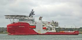
Marine Notice: Surveys Off South & South West Coasts
#MarineNotice - The survey vessel VOS Sweet (Callsign PCPE) is currently conducting offshore geotechnical and environmental survey operations associated with the proposed Celtic Interconnector on behalf of EirGrid.
The VOS Sweet was set to commence operations yesterday, Monday 18 June, and will operate on a 24-hour daily basis for approximately two weeks in two main corridors off East Cork to three landfall points: Ballinwilling Strand (Ballycotton Bay); Redbarn Beach and Claycastle Beach (Youghal Bay).
The survey is to collect geotechnical data utilising a Vibrocorer (VC) and Cone Penetration Test (CPT) spread and environmental (benthic) data utilising Grab Sampler spread. The survey will be conducted under Foreshore Licence FS006811. Common frequency VHF Channel 16 shall be used throughout the project.
Details of the route centreline co-ordinates as well as intended locations for the VC, CPT and benthic sampling are included in Marine Notice No 26 of 2018, a PDF of which is available to read or download HERE.
Meanwhile, Providence Resources is carrying out a site survey on its FEL 6/14 licence, called Newgrange, situated between the Southern Porcupine and Goban Spur Basins some 260km off the South West Coast.
The eight-day geophysical survey by the MV Kommandor (Callsign MCJO2), was scheduled to commence on Monday, is using dual-frequency side scan sonar, single-beam and multi‐beam echosounders, side scan sonar, sub‐bottom profilers and magnetometer.
Seabed (benthic) samples will also be taken using a box corer or grab as appropriate, and geotechnical sampling will be undertaken with a piston corer to a minimum target depth of 6m below the seabed.
In addition to the above, and to accurately determine potential future drilling hazards over the Newgrange location, the proposed survey will also include a high resolution 2D seismic which is not expected to exceed two days.
Survey operations will be conducted on a 24-hour basis. The MV Kommandor will be displaying shapes and lights prescribed in the International Rules for the Prevention of Collisions at Sea (COLREGS) Rule 27, to indicate that the survey vessel is restricted in its ability to manoeuvre. A listening watch will be maintained on VHF Channel 16, and the vessel will actively transmit an AIS signal.
Co-ordinates and a map of the expected working area are outlined in Marine Notice No 25 of 2018, a PDF of which is available to read or download HERE.


 is introduced on the Dover-Calais route in June. The ‘Spirit’ class cruise ferry is to boost capacity on the busy UK-France short-sea trade link in competition with P&O Ferries and DFDS.")
 with club Commodore Graham Skelton")


 will be going head-to-head with long-lost multi-club-representing sister Two Farr at Howth’s three-day Wave Regatta, starting Friday")


 with his best mate, getting into battle mood in the North African desert during World War II of 1939-45. Anyone who gets along well with a Jack Russell terrier, while looking so very like superstar actor Liam Neeson before Neeson was born, must have had some redeeming features - even if he was a danger to all when partying in a new kitchen")

