


Displaying items by tag: buoy
A marker buoy that washed ashore in Co Wexford this week has been traced to as far away as the US state of Louisiana.
The large metal buoy was found on Wednesday (3 April) on the coast at Ballymoney near Gorey by local man Owen J Dunbar, who discovered that despite its dilapidated condition it still bore the name of its manufacturer, Wet Tech.
Dunbar contacted the company by email and received a swift reply from operations manager Todd Carl, who not only confirmed the marker buoy was one of theirs but also provided more details about its origins.
The buoy was manufactured in 2005 after Hurricane Katrina devastated the Gulf Coast region of the US, and had been moored in the middle of the Gulf of Mexico as a marker on an oil platform downed by the storm.
Carl believes the buoy broke its moorings in 2007 as it was recorded as missing during a regular service check, and as it was not fitted with a GPS transmitter its whereabouts were unknown.
It’s now presumed that over the last 17 years, the buoy drifted out of the gulf into the Atlantic and was caught in the Gulf Stream — indeed, it may have circled the North Atlantic more than once over the years before it beached in Wexford this week.
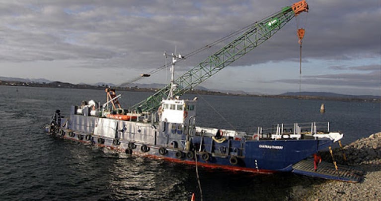
The deployment of an Acoustic Doppler Current Profiler (ADCP) sub-surface installation by University College Dublin, which was scheduled to take place between 15 - 21 October 2020 as Afloat previously reported, will now take place on 7 November 2020.
The deployment will occur approximately 0.60 Nautical Miles from Rock Island lighthouse in a direction of 235° (see Appendix 1). The exact location co-ordinates are as follows:
Latitude: 53°08' 57.4"N
Longitude: 009°52' 23.4"W
The deployment will be carried out by the 'MV Chateau-Thierry'
Yellow spherical marker buoys, 40 cm in diameter will be used. They will flash yellow every 5 seconds.
An acoustic Doppler current profiler (ADCP) is a hydroacoustic current meter similar to a sonar, used to measure water current velocities over a depth range using the Doppler effect of sound waves scattered back from particles within the water column.
The UCD Highwave Project aims to use statistics and fluid mechanics to explore fundamental questions in wave breaking.
Connemara Sea Scouts Solve Mystery Of Marine Research Buoy
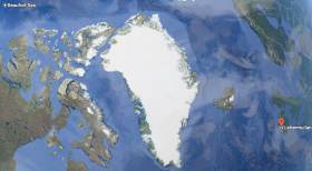
#ArcticBuoy - A marine research buoy found on the Connemara coast by local Sea Scouts recently had drifted over 6,000 kilometres across the Beaufort Sea, Arctic Ocean and Atlantic to Ireland.
The buoy, around half a metre in diameter, was found at Lettermullen by the scout troop during an exploration of their local beach.
Michael Loftus, leader of Gasógaí Mara na Gaeltachta (Connemara Sea Scouts), said they often find flotsam and jetsam washed up on the shore, which they can usually identify.
“However, little did we know that this new find would uncover a world of discovery relating to the buoy being launched from an aircraft in the Arctic Ocean and travelling thousands of kilometres to land on the west coast of Ireland.”
The Marine Institute, which works on a series of projects where autonomous instruments are deployed into the ocean for marine research, was contacted to help solve the mystery of where the red buoy came from.
“Although the buoy is not an Argo float that is typically used by the institute as part of the national Argo float programme, we were delighted to help the Sea Scouts establish that the buoy is in fact an Airborne Expendable Ice Buoy, which came from as far away as the Beaufort Sea,” said Diarmuid Ó Conchubhair of the Marine Institute.
The International Arctic Buoy Programme involves a number of different countries including Canada, China, France, Germany, Japan, Norway, Russia, and the United States.
The programme maintains a network of drifting buoys in the Arctic Ocean that are used to monitor sea surface temperatures, ice concentration, and sea level and support weather forecasting. The buoys are also used for validating climate or earth system models which inform the Intergovernmental Panel on Climate Change (IPCC) reports.
Each buoy in this programme has an identification number that is used to track its location in the Arctic Ocean using a type of satellite communication system.
“Using the number marked on this buoy [#4800512], we were able to establish that this particular buoy had been deployed by an aircraft over five years ago in the Beaufort Sea, north of the Yukon and Alaska, west of Canadian Arctic islands,” said Ó Conchubhair.
Dr Eleanor O’Rourke, oceanographic services manager at the Marine Institute, explained: “Researchers involved in the International Arctic Buoy Programme decide where to deploy buoys, particularly where the status of sea-ice may be changing.
“Most of the buoys are placed on sea ice, but some are placed in open water in some of the most remote parts of the world's ocean, where it is difficult for research vessels to access.”
Airborne Expendable Ice Buoys have an average lifespan of 18 months and around 25 to 40 buoys operate at any given time.
“The buoy last reported its data in 2014 and it is likely that it ran out of battery power and spent the last three to four years at the sea surface travelling via wind and ocean surface currents,” said O’Rourke.
In 2007, Ireland became a member of the international Argo programme, which uses robotic instruments known as autonomous Argo floats that report on subsurface ocean water properties such as temperature and salinity via satellite transmission to data centres.
Using a fleet of around 4,000 autonomous floats around the world, the Argo array is an indispensable component of the Global Ocean Observing System (GOOS).
“Similar to the buoys used by the International Arctic Buoy Programme, Argo floats collect and distribute real time information on the temperature and salinity of the ocean,” said Ó Conchubhair, who is vice chair of the European Argo Programme.
“Argo floats; however, measure these variables from the upper 2,000m of the ocean and help to describe long-term trends in ocean parameters such as their physical and thermodynamic state.”
This information is required to understand and monitor the role of the ocean in the Earth's climate system, in particular the heat and water balance.
Click here for more information about Ireland’s involvement in the Argo programme. You can also track and look at data from Irish Argo floats at Ireland’s Digital Ocean.
Four years ago, another Arctic device was found on the North West Coast and exhibited by Transition Year students in Co Mayo, as previously reported on Afloat.ie.
New Buoy Moorings Proposed for Upper and Lower Lough Erne
#buoy moorings – Waterways Ireland proposes to roll-out a new style of mooring arrangement on Upper and Lower Lough Erne to create an opportunity for boaters to use and experience the waterway differently.
Waterways Ireland has submitted a request for planning permission to allow the creation of 18 buoy moorings across Upper and Lower Lough Erne.
A buoy mooring is a mooring buoy that is permanently attached by chain to an anchor on the lake bed at which a boat may tie up as an alternative to mooring at a jetty or deploying an anchor.
Waterways Ireland is installing this type of public mooring to offer boaters an alternative to mooring at a jetty. The locations have been chosen to provide safe, sheltered moorings in quiet locations. As only one boat can moor at a time, the buoy mooring offers a boater a more natural experience which some boaters are seeking.
In choosing the proposed locations Waterways Ireland has sought comment from user groups, the Environment Agency, Inland Fisheries and the RSPB. It is Waterways Irelands intention to provide safe moorings at locations that that will interest boaters but that will not result in a negative impact or disturbance to bird, fish or mammal species or their habitat.
These locations are not intended to give the boater egress to the land, but to provide a safe mooring opportunity away from other waterways users and offering a more intimate connection to nature.
In selecting the locations for these moorings Waterways Ireland has paid particular attention to the provision of safe navigation and a safe mooring in a range of water depths and wind directions and the avoidance of overhead electric wires (for craft under sail). Waterways Ireland has also taken into account the weight of craft in designing the mooring anchors and intends to cater for the heaviest cruisers presently on the navigation.
If planning permission is secured Waterways Ireland intends to proceed with laying the approved moorings and a number of these will be available for use in 2015.
Maps and information showing the proposed locations can be found on www.waterwaysireland.org
New Lease Of Life In Mayo For Unusual Arctic Visitor
#ArcticBuoy - An extraordinary visitor to Ireland's shores will be the subject of a new exhibition in Belmullet, Co Mayo next week.
As The Irish Times reports, Fergus Sweeney was on the shoreline at Blacksod in north Mayo last autumn when he spotted an unusual buoy floating in the water.
It turned out to be attached to an ice-tethered profiler, or ITP, that had been deployed three years before by American researchers on an ice floe in the Arctic Ocean - some 15,000 miles away.
The device was one of 60 deployed in an network measuring climate change, some of which have been lost, but none had been previously discovered further south than the Outer Hebrides.
But while its working life ended in 2012 thanks to water damage, the device will have a new lease of life thanks to Sweeney and a grow of local Transition Year students who have put together an exhibition tracing the buoy's voyage across the oceans.
The Irish Times has more on the story HERE.
Marine Notice: Rock Placements Off Co Dublin & Buoy Deployments Off West Cast
#MARINE WARNING - The latest Marine Notices from the Department of Transport, Tourism and Sport (DTTAS) advise mariners to keep a look-out for rock placement off north Co Dublin and buoy placements off Co Mayo and Co Clare.
Operations were due to commence on Saturday 8 September at North Beach in Rush, Co Dublin for the placement of rocks offshore and in the Irish Sea for a period of 10-12 days weather permitting.
The works are being undertaken by DPFPV Tideway Rollingstone (call sign PHYR) and DPFPV Stornes (call sign PCKX) at various locations detailed in Marine Notice No 49 of 2012, a PDF of which is available to read or download HERE.
These vessels are operating on a 24-hour basis and will display appropriate days shapes and lights. They are also transmitting an AIS signal and will keep a listening watch on VHF Channel 16 for the duration of the works, which involve the deployment of survey ROVs and fall pipe that will restrict the vessels' movements. All mariners are instructed to give a wide berth.
Meanwhile off the west coast, ESB International has deployed two Waveroder buoys as positions near Achill Island in Co Mayo and Doonbeg in Co Clare.
The Achill buoy will be operational for a minumum of three months from now, while the Killard buoy will be operational for a minimum of 10 months having been recently relocated. Both are spherical and yellow in colour. All vessels are requested to give the buoys a wide berth.
Full details of their positions are included in Marine Notice No 50 of 2012, a PDF of which is available to read or download HERE.
Cork Company Set to Deploy Energy Device at Cornwall's Wave Hub
#POWER FROM THE SEA - An Irish firm has landed a contract to provide a wave device for a new offshore energy test site in Cornwall, Siliconrepublic reports.
Ocean Energy, which is based in Cork, will deploy its first full-scale wave energy device at Wave Hub - described as an 'electrical socket' for testing wave power technology - off Hayle in north Cornwall by the end of the year.
The technology behind the buoy-type device, which will cost €9 million, has been developed over the past three years via a quarter-scale prototype in Galway Bay.
Using the principle of the oscillating water column, the device works by channeling water through a submerged chamber that forces air through a turbine above the surface.
The full-scale unit is expected to generate enough electricity to power as many as 1,200 homes.
Siliconrepublic has more on the story HERE.
Lost Atlantic M3 Weather Buoy Found in Devon

#MARINE INSTITUTE – A weather buoy from the Irish marine weather buoy network was located on a beach in Devon today, 270 miles from home, having lost communication with the network over three weeks ago. A note on the Marine Institute says "Dec 12th 2011 - M3 is experiencing technical problems. Further details will follow"
It now transpires the M3 Weather buoy was torn from its mooring off the South West Coast of Ireland during severe weather conditions on the 10th December, when it ceased transmitting.
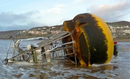
The M3 Weather buoy found on a Devon beach
Following efforts to re-establish communication with the buoy and identify its location, a radio navigational warning was issued on 12th December to warn that the buoy may be adrift. The RV Celtic Voyager also searched the area, but nothing was found until yesterday, Monday 2nd January, when the Argos system on the buoy began reporting positional information from Woolacombe Beach, North Devon.
The weather buoy network was established in 2000 and is run as a collaboration between the Marine Institute, the UK Met office, Met Eireann and the Irish Department of Transport.
View Larger Map
The Marine Institute, Ireland is currently working with the Swansea Coastguard and Parkin Estates, the company that runs Woolacombe beach in Devon to recover the buoy.
A weather buoy technician is travelling from Galway to Devon to assess the damage and the Marine Institute will make every effort to ensure a buoy is restored to the M3 location as soon as possible.
The M3 is part of a network of five weather boys which measure a range of meteorological and oceanographic parameters to provide vital real time data for weather forecasts shipping bulletins, gale and swell warnings
Scientists Await Data from Galway Wave Energy Test

The Irish Times reports that a number of European universities and research centres are eagerly awaiting the data from the latest wave energy test buoy deployed in Galway Bay.
Cork company Ocean Energy Ltd is behind the latest test and research platform, co-ordinated by the hydraulics and marine research centre at University College Cork.
The scheme has €4.5 million in funding approved by the EU and commissioner for research and innovation Máire Geoghegan-Quinn.
A recent study for Sustainable Energy Ireland suggests that ocean-derived energy could generate €9 billion in income and thousands of jobs in the next 20 years.


, marking also a first presence in this market.")


 as lead helm, rounds the Fastnet Rock on the way to the overall win in 1987")


 Michael Murphy Schull Harbour Sailing Club (SHSC), Eric Coogan Heineken Ireland, Mark Murphy, Commodore SHSC, Jack Allen SHSC, Carmel O'Regan SHSC, Cornelious Ndlovu, Schull Harbour Hotel Operations Manager and Derval Murphy SHSC")
