


Displaying items by tag: Corkumnavigate
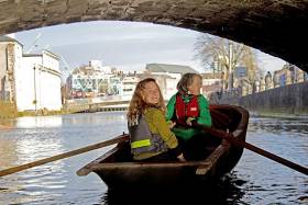
A unique new tidal guide assisting river users to circumnavigate the city’s waterways was launched yesterday at the River Lee Hotel. CORKUMNAVIGATION is a pocket-sized map published by Cork’s community boatyard, Meitheal Mara. The guide is aimed at helping locals and visitors alike discover the city from a new angle by kayak, canoe or rowing boat. See link below to purchase the guide.
According to Cathy Buchanan of Meitheal Mara, ''very few people know that you can actually row or paddle all around the city, and experience a very different and special side of Cork. As several of the bridges are particularly low and some weirs quite high, they can only be passed at certain tides. With the CORKUMNAVIGATION guide you can successfully navigate the city’s 29 bridges and eight weirs at various stages of the tide.''
Niamh Twomey, Cork City Council Heritage Officer, added ''The River Lee is one of the great unexploited spaces in Cork, offering a beautiful route around the historic city centre. This guide will give the growing number of river users the opportunity to experience the natural and built heritage of Cork from the River Lee. The guide also includes quirky historical facts contributed by the late Cían Ó Sé.''
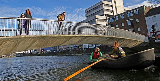
Corkumnavigate Cork city's 29 bridges and eight weirs with this latest pocket guide.
Originating near Gougane Barra in the Shehy Mountains, the River Lee flows east towards Cork City where it splits into two channels, forming the city's central island. Medieval Cork was a network of small river channels, which over the centuries have been covered in to leave just the north and south channels open. The river derives its name from the Irish "Laoi", meaning torrent or flood.
CORKUMNAVIGATION is a Meitheal Mara project, sponsored by Cork City Council and the River Lee Hotel. Fieldwork for the project was conducted in 2010 by the Cork Centre for Architectural Education, UCC and CIT, and sponsored by the Heritage Council.
The CORKUMNAVIGATION guide is available from Meitheal Mara via Afloat's Marine Market. Click HERE.


 with his best mate, getting into battle mood in the North African desert during World War II of 1939-45. Anyone who gets along well with a Jack Russell terrier, while looking so very like superstar actor Liam Neeson before Neeson was born, must have had some redeeming features - even if he was a danger to all when partying in a new kitchen")


