Menu

Ireland's sailing, boating & maritime magazine

Displaying items by tag: Groundfish

#MarineNotice - The latest Marine Notice from the Department of Transport, Tourism and Sport (DTTAS) advises that the Marine Institute is carrying out its annual Irish anglerfish and megrim survey (IAMS 2017) in fulfilment of Ireland’s Common Fisheries Policy obligations from this Tuesday 14 February to Friday 17 March.

The IAMS is a demersal trawl and beam trawl survey consisting of around 85 otter trawls (60 minutes) and 25 beam trawls (30 minutes) in International Council for Exploration of the Sea (ICES) area 7b, 7c, 7g, 7h, 7j and 7k off the West, South West and South Coasts.

Fishing in 2017 will take place within a three-nautical-mile radius of the positions indicated in Marine Notice No 5 of 2017, a PDF of which is available to read or download HERE.

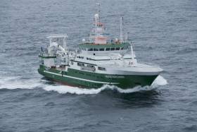
The survey will be conducted by the RV Celtic Explorer (Callsign EIGB), which will display all appropriate lights and signals during the survey and will also be listening on VHF Channel 16.

The vessel will be towing a Jackson demersal trawl or two 4m beam trawls during operations. The Marine Institute requests that commercial fishing and other marine operators to keep a 3nm area around the tow points clear of any gear or apparatus during the survey period outlined above.

While there is no statutory provision for the loss of gear at sea, the Marine Institute will make every effort to avoid gear adequately marked according to legislation that may be encountered in the notified areas.

In the event that an operator has static gear or other obstructions within 3nm of the points listed, it is the responsibility of the owner to notify the survey managers or vessel directly.

This should be communicated by identifying specifically which ‘station’ is of concern using the appendix and contact details provided in the Marine Notice. It is not required to provide positional details of commercial operations beyond 4nm of the survey points provided.

Specifics of any fishing gear or other obstructions that are known and cannot be kept clear of these survey haul locations can be notified using the contact details provided.

Published in Fishing

Galway Port & Harbour

Galway Bay is a large bay on the west coast of Ireland, between County Galway in the province of Connacht to the north and the Burren in County Clare in the province of Munster to the south. Galway city and port is located on the northeast side of the bay. The bay is about 50 kilometres (31 miles) long and from 10 kilometres (6.2 miles) to 30 kilometres (19 miles) in breadth.

The Aran Islands are to the west across the entrance and there are numerous small islands within the bay.

Galway Port FAQs

Galway was founded in the 13th century by the de Burgo family, and became an important seaport with sailing ships bearing wine imports and exports of fish, hides and wool.

Not as old as previously thought. Galway bay was once a series of lagoons, known as Loch Lurgan, plied by people in log canoes. Ancient tree stumps exposed by storms in 2010 have been dated back about 7,500 years.

It is about 660,000 tonnes as it is a tidal port.

Capt Brian Sheridan, who succeeded his late father, Capt Frank Sheridan

The dock gates open approximately two hours before high water and close at high water subject to ship movements on each tide.

The typical ship sizes are in the region of 4,000 to 6,000 tonnes

Turbines for about 14 wind projects have been imported in recent years, but the tonnage of these cargoes is light. A European industry report calculates that each turbine generates €10 million in locally generated revenue during construction and logistics/transport.

Yes, Iceland has selected Galway as European landing location for international telecommunications cables. Farice, a company wholly owned by the Icelandic Government, currently owns and operates two submarine cables linking Iceland to Northern Europe.

It is "very much a live project", Harbourmaster Capt Sheridan says, and the Port of Galway board is "awaiting the outcome of a Bord Pleanála determination", he says.

90% of the scrap steel is exported to Spain with the balance being shipped to Portugal. Since the pandemic, scrap steel is shipped to the Liverpool where it is either transhipped to larger ships bound for China.

It might look like silage, but in fact, its bales domestic and municipal waste, exported to Denmark where the waste is incinerated, and the heat is used in district heating of homes and schools. It is called RDF or Refuse Derived Fuel and has been exported out of Galway since 2013.

The new ferry is arriving at Galway Bay onboard the cargo ship SVENJA. The vessel is currently on passage to Belem, Brazil before making her way across the Atlantic to Galway.

Two Volvo round world races have selected Galway for the prestigious yacht race route. Some 10,000 people welcomed the boats in during its first stopover in 2009, when a festival was marked by stunning weather. It was also selected for the race finish in 2012. The Volvo has changed its name and is now known as the "Ocean Race". Capt Sheridan says that once port expansion and the re-urbanisation of the docklands is complete, the port will welcome the "ocean race, Clipper race, Tall Ships race, Small Ships Regatta and maybe the America's Cup right into the city centre...".

The pandemic was the reason why Seafest did not go ahead in Cork in 2020. Galway will welcome Seafest back after it calls to Waterford and Limerick, thus having been to all the Port cities.

© Afloat 2020