Displaying items by tag: Atlantic Ocean
Crossing The Atlantic 200 Times to Promote Marine Interest
The organisation, which has launched two hundred small sailing boats to cross the Atlantic Ocean, fostering interest in the sea and developing cultural links amongst nations, intends to develop the project further following a particularly positive response from a coastal village community in West Cork.
At Barryroe National School, the organisers of the US Educational Passages project met teachers, fishing and marine tourism representatives who had recovered one of their boats after contact had been lost with it and then it was found in and recovered from a cave at Barry’s Cove on the West Cork coastline, refurbished and re-launched, arriving back in USA waters of Nantucket, Cape Cod, Massachusetts, a historic American maritime location, from which the story has developed further.
 Morristown USA are now linked with Barryroe National School thanks to a small sailing boat that crossed the Atlantic
Those two crossings of the Atlantic showed how maritime interest can be developed amongst young people through local communities, and, for my Podcast below, I was in Barryroe National School when the Educational Passages representatives from the US linked two schools across the Atlantic which had partnered in the project. They also had meetings with other Irish groups interested in the project.
French Solo Rower Lost at Sea After Distress Beacons Activated
A French adventurer who previously crossed the Atlantic in a barrel is missing and presumed dead at sea just weeks after beginning a solo crossing by row boat.
Jean-Jacques Savin, who was 75, had set out on 1 January from Sagres in Portugal for Martinique in the Caribbean on what was planned as a three-month voyage.
He was posting updates of his journey on Facebook and wrote last Wednesday (19 January) that despite strong winds and issues with his specialised row boat’s solar panels, he was “not in danger”, as BBC News reports.
But on Thursday (20 January) two distress beacons were activated from Savin’s position en route to the Azores, and the following day his vessel Audacieux was found overturned.
Despite earlier reports that Savin’s body had been found in his cabin, his daughter Manon confirmed on Sunday night (23 January) that his boat was found empty and a body was not recovered.
Health Check for the Atlantic on the Ocean Climate Survey
Scientists from the Marine Institute, Maynooth University and the National University of Ireland Galway were recently aboard the RV Celtic Explorer, for a 14-day scientific survey studying the shelf and deep water off the west coast of Ireland. This Marine Institute’s annual ocean climate survey has been running since 2006 and facilitates long-term physical and biogeochemical observations of the deepwater environment in the South Rockall Trough.
The Rockall Trough is an important region that provides a pathway for the transport of heat and salt from the North-East Atlantic to the Nordic Seas, where waters are subjected to phenomena such as deep convective mixing that creates cold dense water. Water exchange and interactions in the Rockall Trough play a fundamental part in the overall thermohaline circulation in the North-East Atlantic; as large volumes of warm water pass through the Rockall Channel, before flowing into the Nordic Seas with a return of cold dense bottom water outflow spilling into the region. Changes in the region’s water properties, such as temperature and salinity, vary on inter-annual and decadal time scales.
Chief Scientist on the research survey, Dr Caroline Cusack of the Marine Institute said, “Scientific data collected on this survey allows the assessment of interannual variability of physical and biogeochemical conditions that impact shelf and deep waters. This variability can have a range of impacts on ocean ecosystems, ocean circulation and weather patterns. The survey contributes to activities of the International Council for the Exploration of the Sea and provides support to the Convention for the protection of the marine environment of the North-East Atlantic (OSPAR Convention), the Marine Strategy Framework Directive focused on protecting ocean health, and climate change assessments.”
This year, Maynooth University scientists from the A4 project (Aigéin, Aeráid, agus athrú Atlantaigh = Oceans, Climate, and Atlantic Change) joined the survey to work with the Marine Institute oceanographic and climate services team. The A4 project, supported by Marine Institute funding, studies how changes in the Atlantic impact Ireland and northwestern Europe through changes in ocean circulation and sea level and is developing predictive capacity for these regions. Recent research by the A4 project found that the Gulf Stream System, also known as the Atlantic Meridional Overturning Circulation (AMOC), is at its weakest in over a millennium.
Scientists from the National University of Ireland, Galway were also on board the RV Celtic Explorer working with Marine Institute chemists to collect supporting chemistry information. The NUI Galway scientists are currently working on the Marine Institute funded VOCAB project (Ocean Acidification and Biogeochemistry: Variability and Vulnerability) to enhance knowledge on the vulnerability of selected marine ecosystems in Irish waters to ocean acidification. NUI Galway scientists also collected samples relevant to the JPI Climate and JPI Oceans CE2COAST project which aims to downscale global climate models to regional and local scales to provide information on the impacts of climate change tailored to local needs.
Mick Gillooly, Director of Ocean Climate and Information Services at the Marine Institute said, “Collaborative oceanographic research is very important to help inform Ireland’s response to climate change and underlines the importance of researching marine impacts of climate change, which could have a significant societal impact on Ireland. The Marine Institute’s annual climate survey, with scientific experts from collaborating research groups, enables us to generate a long-term time series of key oceanographic data to further increase our knowledge about our changing ocean climate.”
This year, 51 stations were occupied with 301 depths sampled. At each station, scientists profile the full water column and collect measurements of temperature, salinity and oxygen. Water samples are collected at targeted depths and analysed on board to determine the salinity, dissolved oxygen, inorganic nutrients and carbon content (DIC/TA). The RV Celtic Explorer’s advanced underway data acquisition system gathers information on temperature, salinity, fluorescence, and pCO2 in surface waters. This year, the Marine Institute also had a laboratory on board equipped with state-of-the-art analysers, enabling near real-time reporting of nutrients, oxygen and salinity.
The annual ocean climate survey supports a number of Marine Institute ocean observation programmes. The Irish Marine Data Buoy Observation Network, managed by the Marine Institute in collaboration with Met Éireann, is a network of five offshore weather observing marine buoys around Ireland. The M6 Data Buoy, located hundreds of kilometres to the west of Ireland in the South Rockall Trough, was a station sampled during this scientific survey.
A Marine Institute glider, an underwater autonomous vehicle, was also deployed near the M6 Data Buoy during this survey. The glider can reach depths of 1,000 metres and collects oceanographic data on conductivity, temperature, depth, fluorescence, turbidity and dissolved oxygen. Since its deployment, the glider has travelled more than 350 kilometres collecting additional oceanographic data for the scientists involved.
Scientists also deployed two Argo Floats, which measure temperature, salinity and depth with one Argo Float also taking measurements of the water oxygen content. Argo Floats are autonomous instruments that remain at sea for a period of three to five years which provide high-quality temperature and salinity depth profiles while ascending and descending to and from the surface from a depth of 2,000 metres, as it drifts through the ocean. There are currently about 4,000 Argo Floats in the world's oceans. As part of Ireland’s participation in the Euro-Argo ERIC Programme, the Marine Institute deploys three Argo Floats each year.
The track and data from current Irish Argo Floats can be viewed here
The annual ocean climate survey, the A4 project and VOCAB (Ocean Acidification and Biogeochemistry: variability, trends and vulnerability) are supported by the Marine Institute under the Marine Research Programme funded by the Irish Government.
#MarineWildlife - Marine scientists have found new discoveries after returning to Galway Port, having spent three weeks at sea investigating Ireland's deep ocean territory 300 miles off the west coast. The deep sea expedition involved the Marine Institute's remotely operated vehicle (ROV) Holland 1 onboard the Commmissioners of Irish Lights ILV Granuaile.
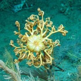
The high definition ROV-mounted video captured a number of 'firsts' in Irish waters, including a species of octocoral of the genus Corallium, which grows into huge fans with a delicate porcelain-like skeleton, and a species of black coral different to others described to date, which may prove to be an entirely new species.
The survey confirmed Irish deep-waters as a haven for these rare and delicate deep-sea black corals. The team of scientists also reported areas of potential 'sponge reef' on the Rockall Bank, a highly unusual accumulation of living and dead sponges forming a complex habitat for many other creatures. Such formations are very rare and have previously only been recorded in Canadian waters.
Cold water coral reefs are ecosystems that host a diverse range of marine animals including sea fans, sponges, worms, starfish, crustaceGorgonocephalus - An Ophiuroid Basket starans and a variety of fish species, making them vitally important habitats for marine biodiversity. These fragile deepwater reefs are commonly associated with topographic features subject to strong bottom currents, for example continental margins, seamounts and mid-ocean ridges, because as filter feeders, the corals depend on suspended food particulate matter. The high resolution bathymetric dataset acquired as part of the national seabed mapping programme –Integrated Mapping For the Sustainable Development of Ireland's Marine Resource (INFOMAR) - was used to target potential locations of reef habitat for this survey by identifying specific seabed morphological features likely to support cold water coral. The last two decades have seen a dramatic increase in our understanding of the cold water coral reef ecosystems, their susceptibility to environmental change, and their low resilience to human impact.
Chief Scientist on the SeaRover survey, David O'Sullivan, Marine Institute said: "We are very pleased to discover what appear to be new coral species and a rare sponge reef, neither of which have been previously documented in Irish waters. These sensitive habitats are very important and this study is key to getting a better understanding of Irelands' deep sea. Our key objective is to discover, protect and monitor Ireland's rich offshore marine biodiversity so we can manage our marine resources effectively. Without a knowledge of what lives on our seabed we are at risk of never fully understanding and appreciating Ireland's invaluable marine environment."
Dr Kerry Howell, Plymouth University said: "This is the first time I have seen a sponge reef like this in nearly 20 years of studying the deep NE Atlantic. This is an important find. Sponges play a key role in the marine ecosystem providing habitat for other species and recycling nutrients. They may even be a source of new antibiotics. These new data will help ROV Holland 1. Picture Credit Aodhan Fitzgeraldus to better understand where and why these reefs occur."
Prof. Louise Allcock, NUI Galway, who is funded by Science Foundation Ireland and the Marine Institute to study the pharmaceutical potential of deep-sea corals and sponges added: 'This project highlights collaboration and cooperation between Irish and international marine scientists, helping us to further our understanding of these sensitive ecosystems and has also been able to provide training opportunities and sea-going experience for young scientists.
The 'SeaRover' survey is the second of three planned expeditions jointly funded by the Irish Government and the EU's European Maritime and Fisheries Fund (EMFF). The cross government initiative is supported by the Department of Agriculture, Food and Marine, Department of Culture, Heritage and Gaeltacht, and Department of Communications, Climate Action and Environment (DCCAE) as part of the Marine Institute's implementation of the Marine Biodiversity scheme.
Survey operations were coordinated and led by the DCCAE funded INFOMAR programme, which is a joint venture between the Geological Survey Ireland and the Marine Institute. This year's expedition extended the habitat exploration area to the Rockall Bank, the farthest offshore extent of Ireland's Economic Exclusive Zone. Scientific experts onboard to witness the exciting findings were from the Marine Institute, National Parks and Wildlife Service, National University of Ireland Galway and Plymouth University.
Scientists Discuss 'Unknown Treasure' Of The Atlantic Ocean
#MarineScience - The Atlantic Ocean: Our Unknown Treasure was on the agenda at the annual meeting of the American Association for the Advancement of Science (AAAS) in San Jose, California on Saturday 14 February.
Marine Institute chief executive Dr Peter Heffernan joined European Commission officials and leading scientists from the USA, Europe and Canada to discuss how to explore the largely unknown Atlantic Ocean; how new technologies can help us to challenge our understanding of the planet; and how new observation and visualisation tools can improve what we know about the seabed and inform science to help shape future marine policy.
The event built on the Galway Statement on Atlantic Ocean Research Co-operation signed at the Marine Institute in May 2013 by representatives from the EU, Canada and the US, launching an Atlantic Ocean Research Alliance.
Its goals are to better understand the Atlantic and the Arctic, to study the interplay between them, particularly relating to climate change, and to promote sustainable management of their resources.
Speaking about the event, Dr Heffernan said: "It's an exciting time, as all sides - European, US and Canadian - have shown engagement, planning and commitment to driving the Atlantic Ocean Research Alliance forward and preparing joint actions.
"There are very real global challenges to be tackled, and there is strong momentum now to create significant benefits such as better ecosystem assessments and forecasts and deeper understandings of vulnerabilities and risks.
"These transatlantic collaborations will also help to generate new tools to increase resilience and adaptation and to conserve our rich biodiversity. We also really need to foster public understanding of how ocean science and observation will address pressing issues for citizens and for the environment."
Dr Heffernan concluded: "The AAAS meeting gave an opportunity to see some of the collaborations that are undertaken in the Atlantic Ocean and discuss challenges for future research, technological developments, mapping and imaging as well as research co-operation across the Atlantic."
Abandoned Yacht Surprises Donegal Skipper
#GhostShip - It was an unsettling discovery for a Donegal skipper to happen upon a deserted yacht drifting in the Atlantic Ocean last week.
As BBC News reports, the unmanned vessel materialised in fog off Downings harbour in the north-west of the county, evoking memories of the famous Mary Celeste.
Fearing the worst, local charter boat operator Michael McVeigh sent two divers abroad to investigate, and all they found were rotting food and an e-mail address left on a note on the table.
But the mystery was soon solved after McVeigh contacted Malin Head coastguard - who confirmed that the yacht's owner had been rescued some 600 miles west of Galway.
The yachtsman had been sailing on a "dream trip" from his home in the Azores towards Iceland when he encountered difficulties and used his satellite phone to call for help.
He was later picked up by a passing freighter, leaving his yacht to drift.
BBC News has more on the tale here.
Marine Institute To Be Centre of Global Marine Research
#MarineScience - Galway Bay FM reports that the Marine Institute in Galway is to become one of the world's leading marine research centres.
The news comes in the wake of a groundbreaking deal signed in Galway on Friday afternoon (24 May) between the EU, the US and Canada to join forces on Atlantic Ocean research, as previously reported on Afloat.ie.
All partners have agreed to commit to funding to study the interplay of the Atlantic with the Arctic Ocean, and discover ways that research on the oceans and marine wildlife can contribute to scientific advances in other areas.
Meanwhile, a monitoring system for waste waters is among the projects that will benefit from a near €1 million in funding from the Science Foundation.
Research Minister Seán Sherlock announced the funding for projects at NUI Galway that is hoped to deliver "commercialisation of research in a range of areas".
Oil Field Off Kerry Could Produce One Billion Barrels
#KERRY OIL - Oil exploration firm Petrel Resources has announced it has found as much as one billion barrels of oil off the coast of Co Kerry.
The Irish Independent reports on the findings by the Dublin-based company which show enormous reserves of oil in the Porcupine Basin off the south-west coast.
As previously reported on Afloat.ie, the company said in September that it has identified a number of targets across the more than 1,400 sq km area of the Atlantic Ocean west of Dursey Island.
Technical studies conducted then on blocks in the northern and eastern parts of the basin for reservoir sands were described as "encouraging".
Now Petrel says that computer analysis shows several oil fields stacked in layers that could be tapped by a smaller number of oil wells.
The distance from shore - approximately 200km - plus the location of the oil reserves beneath 1km of water and a further 3km of rock present some difficulties, but new techniques in the oil industry are allowing previously undrillable resources to be extracted.
Petrel Resources is seeking a partner to invest in drilling for oil, and is preparing its application to the Government for a licence.
The Irish Independent has more on the story HERE.
Hazardous Cargo Containers Drifing Towards Ireland
PORT & SHIPPING NEWS - A number of hazardous containers believed to have fallen from a cargo ship this summer are drifting towards Ireland's southwest coast, the Irish Examiner reports.
The containers are said to have slipped from the deck of the MSC Flaminia, a German-registered cargo vessel which caught fire on 14 July in the middle of the Atlantic Ocean, with the loss of two crew and forcing the rest to abandon ship.
The vessel had been en route from North Carolina in the United States to Brememhaven in northern Germany when the incident occurred.
Among the thousands of containers it was carrying were 149 classed as 'dangerous goods', their exact nature not yet confirmed, and it is thought some of these are among the containers that fell into the sea and went missing as the ship listed in mid-ocean.
As reported by the Maritime Bulletin, there was some speculation as to whether the missing containers slipped off deck or were jettisoned.
The containers have since appeared in the main cargo shipping lanes off the southwest coast, posing a danger to transatlantic vessels.
Operations have already begun to retrieve the containers and tow them into Castletownbere in West Cork.
The Irish Examiner has more on the story HERE.
Father-Son Duo in Charity Paddle from Dublin to Donegal
#KAYAKING - A father-and-son duo from north Co Dublin will shortly embark on an epic kayak paddle from Dublin to Donegal, the Fingal Independent reports.
Dermot Higgins and his son Fionn, from Rush, will attempt to kayak from Dublin Port to the Atlantic Ocean at Ballyshannon - a distance of some 330km - by way of the Royal Canal, the River Shannon and Lough Erne.
The Higgins' - who believe they are the first to attempt such a feat - will be completely self-sufficuent for the duration of the challenge, which is hoped to raised funds for the Rush Open Organisation for Transition Status (ROOTS), a charity that intends to help communities reduce their carbon footprint and face up to environmental challenges by encouraging sustainability.
The Fingal Independent has more on the story HERE.


