Menu

Ireland's sailing, boating & maritime magazine

Displaying items by tag: East Wall

The Irish economy “couldn’t function” without the “central role of Dublin Port”, Minister for Public Expenditure Paschal Donohoe has said.

Speaking at the opening of Dublin Port’s Substation as an interpretive centre and venue, Mr Donohoe said that Dublin began as a port city, and it was easy to forget this.

“We understand that better about our history than we do about our present,” he said, stating the port is “a vital piece of national infrastructure that is an artery not just to our city, but to our economy”.

The Fine Gael minister, whose constituency is Dublin Central, said this could best be appreciated when walking out to the end of the North Bull Wall and observing the shipping traffic in the bay with “the wind in your face and the salt on your lips”.

He paid tribute to Dublin Port for “opening up walls and gates”, with the refurbished Substation being a prime example of this.

Dublin Port chief executive Barry O’Connell noted that the opening was taking place on national culture night, when a plaque honouring Bindon Blood Stoney, one of the port’s most pioneering engineers, would also be unveiled.

“Today marks another significant milestone in our journey towards making Dublin Port a destination, and achieving port-city integration,” O’Connell said.

The Substation’s opening and discovery and preservation of the 18th century sea wall, which gave East Wall its name symbolises the port’s “commitment to bridging the past and present”.

During refurbishment works on site, part of the city’s original sea wall was discovered running underneath the Substation. The 18th century sea wall once served to protect the East Wall from flooding and was a catalyst for the North Lotts reclamation of centuries ago. Dublin Port, together with a multidisciplinary team has worked to preserve and expose the sea wall underneath a glass floor inside the building. During refurbishment works on site, part of the city’s original sea wall was discovered running underneath the Substation. The 18th century sea wall once served to protect the East Wall from flooding and was a catalyst for the North Lotts reclamation of centuries ago. Dublin Port, together with a multidisciplinary team has worked to preserve and expose the sea wall underneath a glass floor inside the building  Photo: Conor McCabe

“As we continue our efforts to connect the port with the city, this interpretive centre becomes a vital part of Masterplan 2040, fostering a deeper connection between our maritime heritage and the community,” he said.

Dublin Port heritage director Lar Joye said the Substation marked the point where the “port meets the city”, and once played a pivotal role in the early electrification of the port complex.

The 18th-century sea wall discovered running underneath the Substation once served to protect the East Wall from flooding and was a catalyst for the North Lotts reclamation of centuries ago.

One of the Substation’s first events will be an exhibition curated by the Little Museum of Dublin in November, entitled “Solidarity: the Dockers of Dublin Port”.

A tribute to the dockers was the theme of a short performance at the Substation opening by ANU actor Robbie O’Connor, based on a short extract from “The Book of Names” by Louise Lowe.

When completed, the redbrick Substation museum display would be part of a 6.2 km cycle and pedestrian route linking port, maritime and industrial heritage landmarks and views from Dublin Port estate and overlooking Dublin Bay, Joye said.

The Liffey-Tolka project recently acquired planning permission to create a “transformative public realm” along a 1.4 km dedicated cycle and pedestrian route linking the Liffey with Tolka estuary, passing the Substation en route as part of a greenway.

Attending the event at the Substation – and assisting the minister in ringing a ship’s bell before he unveiled the section of the old sea wall - were Adam Roche (9) and Everly Whelan (9) of St Joseph’s Co-Ed Primary School.

Adam Roche, 9, and Everly Whelan, 9, of St. Joseph’s Co-Ed Primary School, at the launch of the Substation at Dublin Port Photo: Conor McCabeAdam Roche, 9, and Everly Whelan, 9, of St. Joseph’s Co-Ed Primary School, at the launch of the Substation at Dublin Port Photo: Conor McCabe

Their school board chairperson, former Dublin Central Independent TD Maureen O’Sullivan, also attended the opening, along with members of the Ringsend and East Wall communities.

Published in Dublin Port
Tagged under

Part of Dublin’s original sea wall dating back to the late 1720s has been discovered during excavations beneath a former electricity substation at Dublin Port.

Announcing the find today (Wednesday 5 October), Dublin Port Company also revealed the discovery of dockworker artefacts including clay pipes, leather shoe parts and pottery fragments from the 19th century.

The “historic” unearthing was made during works being carried out on the former redbrick electricity substation located near the junction of East Wall Road and Alexandra Road in the grounds of Port Centre.    

“The original sea wall once enclosed the eastern and northern sides of newly reclaimed land that would become known as the North Lotts – acting as a polder,” the port company explains.

“As the port extended eastwards away from the city, the sea wall’s original purpose became obsolete, and the facing stones of the wall were removed.

“It is likely that the stones were re-used to construct the three-metre-high boundary wall that defines the port’s perimeter today, visible from East Wall Road. It is from this original sea wall that the area known as East Wall derives its name today.”   

Jim Kelleher, head of special projects with the port’s heritage and communications team, said: “We have long suspected that part of the original sea wall may have lain beneath the old redbrick substation, which itself is a protected structure.

“But it has been incredibly exciting to have those suspicions confirmed, and to see this part of the original ‘East Wall’ for the first time.” 

The port company promises that the sea wall — visible through a glass floor — and related items will on permanent display within the restored substation at Port Centre. Dublin Port has more on the story HERE.

Published in Dublin Port

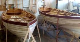
East Wall Water Sports Club will launch two new clinker–built rowing boats next month. The hand–crafted punts were built with the support of Dublin Port Company and Dublin City Council. 

East Wall Water Sport’s was founded in 1981 provides a wide variety of water sports activities to the local community. The new rowing boats will add to their growing fleet of vessels, which promotes coastal rowing on Dublin’s north side, according to the club's Martin Whelan.

'With the help of many other volunteers from the East Wall skiff rowing club the project has finally coming to an end. It’s wonderful to see at first hand the boatbuilding skills which our Viking ancestors handed down to us, still in use today', said Whelan.

The project began in October 2015 and the two clinker built boats, are to be blessed and launched on Sat 1st Oct at 12 noon.

With the growing popularity of rowing within the club, the skiff rowing section saw the need for these new vessels. These boats will primarily be to teach younger children the skills of rowing.

The current project is just one of numerous projects completed by this partnership over recent years that keeps alive an age old tradition of wooden boat building.

To date the club has refurbished two 26 ft rowing skiffs and built currachs and naomhogs in their workshop. Dublin Port Company provided free of charge the services of their resident shipwright Patsy Whelan and his apprentice Stephen, on a weekly basis to supervise the project.

East Wall Water Sports Club through their skiff rowing section and currach section now provide great rowing experiences for all ages at a very minimal cost. The club is open to all, young and old, and a friendly atmosphere is always maintained.


Published in Coastal Rowing

Ireland's offshore islands

Around 30 of Ireland's offshore islands are inhabited and hold a wealth of cultural heritage.

A central Government objective is to ensure that sustainable vibrant communities continue to live on the islands.

Irish offshore islands FAQs

Technically, it is Ireland itself, as the third largest island in Europe.

Ireland is surrounded by approximately 80 islands of significant size, of which only about 20 are inhabited.

Achill island is the largest of the Irish isles with a coastline of almost 80 miles and has a population of 2,569.

The smallest inhabited offshore island is Inishfree, off Donegal.

The total voting population in the Republic's inhabited islands is just over 2,600 people, according to the Department of Housing.

Starting with west Cork, and giving voting register numbers as of 2020, here you go - Bere island (177), Cape Clear island (131),Dursey island (6), Hare island (29), Whiddy island (26), Long island, Schull (16), Sherkin island (95). The Galway islands are Inis Mór (675), Inis Meáin (148), Inis Oírr (210), Inishbofin (183). The Donegal islands are Arranmore (513), Gola (30), Inishboffin (63), Inishfree (4), Tory (140). The Mayo islands, apart from Achill which is connected by a bridge, are Clare island (116), Inishbiggle (25) and Inishturk (52).

No, the Gaeltacht islands are the Donegal islands, three of the four Galway islands (Inishbofin, like Clifden, is English-speaking primarily), and Cape Clear or Oileán Chléire in west Cork.

Lack of a pier was one of the main factors in the evacuation of a number of islands, the best known being the Blasket islands off Kerry, which were evacuated in November 1953. There are now three cottages available to rent on the Great Blasket island.

In the early 20th century, scholars visited the Great Blasket to learn Irish and to collect folklore and they encouraged the islanders to record their life stories in their native tongue. The three best known island books are An tOileánach (The Islandman) by Tomás Ó Criomhthain, Peig by Peig Sayers, and Fiche Blian ag Fás (Twenty Years A-Growing) by Muiris Ó Súilleabháin. Former taoiseach Charles J Haughey also kept a residence on his island, Inishvickillaune, which is one of the smaller and less accessible Blasket islands.

Charles J Haughey, as above, or late Beatle musician, John Lennon. Lennon bought Dorinish island in Clew Bay, south Mayo, in 1967 for a reported £1,700 sterling. Vendor was Westport Harbour Board which had used it for marine pilots. Lennon reportedly planned to spend his retirement there, and The Guardian newspaper quoted local estate agent Andrew Crowley as saying he was "besotted with the place by all accounts". He did lodge a planning application for a house, but never built on the 19 acres. He offered it to Sid Rawle, founder of the Digger Action Movement and known as the "King of the Hippies". Rawle and 30 others lived there until 1972 when their tents were burned by an oil lamp. Lennon and Yoko Ono visited it once more before his death in 1980. Ono sold the island for £30,000 in 1984, and it is widely reported that she donated the proceeds of the sale to an Irish orphanage


Yes, Rathlin island, off Co Antrim's Causeway Coast, is Ireland's most northerly inhabited island. As a special area of conservation, it is home to tens of thousands of sea birds, including puffins, kittiwakes, razorbills and guillemots. It is known for its Rathlin golden hare. It is almost famous for the fact that Robert the Bruce, King of Scots, retreated after being defeated by the English at Perth and hid in a sea cave where he was so inspired by a spider's tenacity that he returned to defeat his enemy.

No. The Aran islands have a regular ferry and plane service, with ferries from Ros-a-Mhíl, south Connemara all year round and from Doolin, Co Clare in the tourist season. The plane service flies from Indreabhán to all three islands. Inishbofin is connected by ferry from Cleggan, Co Galway, while Clare island and Inishturk are connected from Roonagh pier, outside Louisburgh. The Donegal islands of Arranmore and Tory island also have ferry services, as has Bere island, Cape Clear and Sherkin off Cork. How are the island transport services financed? The Government subsidises transport services to and from the islands. The Irish Coast Guard carries out medical evacuations, as to the RNLI lifeboats. Former Fianna Fáíl minister Éamon Ó Cuív is widely credited with improving transport services to and from offshore islands, earning his department the nickname "Craggy island".

Craggy Island is an bleak, isolated community located of the west coast, inhabited by Irish, a Chinese community and one Maori. Three priests and housekeeper Mrs Doyle live in a parochial house There is a pub, a very small golf course, a McDonald's fast food restaurant and a Chinatown... Actually, that is all fiction. Craggy island is a figment of the imagination of the Father Ted series writers Graham Linehan and Arthur Mathews, for the highly successful Channel 4 television series, and the Georgian style parochial house on the "island" is actually Glenquin House in Co Clare.

Yes, that is of the Plassey, a freighter which was washed up on Inis Oírr in bad weather in 1960.

There are some small privately owned islands,and islands like Inishlyre in Co Mayo with only a small number of residents providing their own transport. Several Connemara islands such as Turbot and Inishturk South have a growing summer population, with some residents extending their stay during Covid-19. Turbot island off Eyrephort is one such example – the island, which was first spotted by Alcock and Brown as they approached Ireland during their epic transatlantic flight in 1919, was evacuated in 1978, four years after three of its fishermen drowned on the way home from watching an All Ireland final in Clifden. However, it is slowly being repopulated

Responsibility for the islands was taking over by the Department of Rural and Community Development . It was previously with the Gaeltacht section in the Department of Media, Tourism, Arts, Culture, Sport and the Gaeltacht.

It is a periodic bone of contention, as Ireland does not have the same approach to its islands as Norway, which believes in right of access. However, many improvements were made during Fianna Fáíl Galway West TD Éamon Ó Cuív's time as minister. The Irish Island Federation, Comdháil Oileáin na hÉireann, represents island issues at national and international level.

The 12 offshore islands with registered voters have long argued that having to cast their vote early puts them at a disadvantage – especially as improved transport links mean that ballot boxes can be transported to the mainland in most weather conditions, bar the winter months. Legislation allowing them to vote on the same day as the rest of the State wasn't passed in time for the February 2020 general election.

Yes, but check tide tables ! Omey island off north Connemara is accessible at low tide and also runs a summer race meeting on the strand. In Sligo, 14 pillars mark the way to Coney island – one of several islands bearing this name off the Irish coast.

Cape Clear or Oileán Chléire is the country's most southerly inhabited island, eight miles off the west Cork coast, and within sight of the Fastnet Rock lighthouse, also known as the "teardrop of Ireland".
Skellig Michael off the Kerry coast, which has a monastic site dating from the 6th century. It is accessible by boat – prebooking essential – from Portmagee, Co Kerry. However, due to Covid-19 restrictions, it was not open to visitors in 2020.
All islands have bird life, but puffins and gannets and kittiwakes are synonymous with Skellig Michael and Little Skellig. Rathlin island off Antrim and Cape Clear off west Cork have bird observatories. The Saltee islands off the Wexford coast are privately owned by the O'Neill family, but day visitors are permitted access to the Great Saltee during certain hours. The Saltees have gannets, gulls, puffins and Manx shearwaters.
Vikings used Dublin as a European slaving capital, and one of their bases was on Dalkey island, which can be viewed from Killiney's Vico road. Boat trips available from Coliemore harbour in Dalkey. Birdwatch Ireland has set up nestboxes here for roseate terns. Keep an eye out also for feral goats.
Plenty! There are regular boat trips in summer to Inchagoill island on Lough Corrib, while the best known Irish inshore island might be the lake isle of Innisfree on Sligo's Lough Gill, immortalised by WB Yeats in his poem of the same name. Roscommon's Lough Key has several islands, the most prominent being the privately-owned Castle Island. Trinity island is more accessible to the public - it was once occupied by Cistercian monks from Boyle Abbey.

©Afloat 2020