Menu

Ireland's sailing, boating & maritime magazine

Displaying items by tag: INFOMAR

#INFOMAR – The Integrated Mapping for the Sustainable Development of Ireland's Marine Resource, in short (INFOMAR) have outlined their proposed mapping operations for 2013.

INFOMAR (covering 125,000 sq kms) is a joint venture between the Geological Survey of Ireland (GSI) and the Marine Institute.

During the current year of INFOMAR Phase 1 (2006-2016), operations are provisionally planned to take place within tabulated bays subject to approval from other agencies.

To see a map of proposed working area and more, Inshore Ireland (February / March) issue has a report.

As previously reported on Afloat.ie, the GSI's survey vessel RV Keary last month returned to service, having completed modifications carried out at Arklow Marine Services. The 15m aluminium catamaran research vessel was built in South Africa and is equipped with a full geographical suite.

Published in Marine Science

#LECTURE – Captain Bligh is the topic of the next lecture organised by the Dublin Bay Old Gaffers Association, held in the Poolbeg Yacht & Boat Club, Dublin Port on 20 November.

The illustrated talk (8pm) is to be presented by Sean Cullen, Senior Hydrographer, INFOMAR and whose predecessor was the Irish National Seabed Survey.

In addition limited copies of a new stunning publication "Warships, U-Boats & Liners - A Guide to Shipwrecks Mapped in Irish Waters" will be made available to purchase. The book which was launched today, showcases some of the more spectacular and important shipwrecks in Irish waters.

All are welcome to attend the DBOGA lecture programme noting there will be a door contribution for the RNLI.

Published in Boating Fixtures
High Resolution images of a merchant ship which was sunk ninety-four years ago today (October 12th) off the coast of Dublin have been revealed by the INFOMAR (Integrated Mapping For the Sustainable Development of Ireland's Marine Resource) Programme during a mission on the national research vessel the RV Celtic Voyager earlier this year which surveyed the wreck of the first Guinness merchant vessel, the W.M. Barkley.

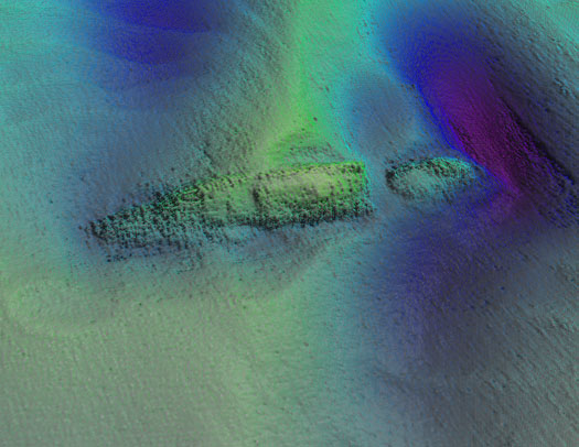
The detailed seabed images, which include deck features and complex sand wave structures, were recorded by towed sidescan sonar provided by the Moore Marine Group, and give a visual insight into the defensively armed ship that was sunk by a German torpedo in 1917, seven miles east of the Kish Bank off Dublin.

Photo_1_INFOMAR_image_of_W_M_Barkley_from_port_aft

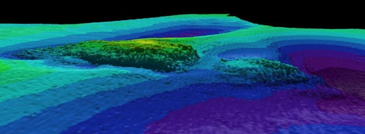
Photos above and below show topographic seafloor images in 3D, showing the partially buried wreck of the W M Barkley lying at a water depth of 56 metres; with deeper scouring around it down to 72 metres (darker colours indicate greater depths). The images were created from sonar data acquired onboard the Marine Institute's research vessel RV Celtic Voyager, during INFOMAR Programme mapping in 2010 and 2011 with data processed by INFOMAR's Fabio Sacchetti (University of Ulster) and Charise McKeon (Geological Survey of Ireland).

W_M_Barkley

In May 2010, during a large scale mapping survey in the Irish Sea by INFOMAR, a national marine study run by the Marine Institute and the Geological Survey of Ireland, identified a seabed feature which, to the trained eye, was discernable as a potential shipwreck lying in the same position recorded on the Admiralty Chart, the EU wreck site and UK Hydrographic Office wreck site directories, as well as a survey conducted in the 1980s as the last known position of the W.M.Barkley.

Viewing the spectacular imagery of the shipwreck Minister for Communications, Energy & Natural Resources, Pat Rabbitte, said "I am delighted to note the continued excellence of the valuable work being carried out under the INFOMAR project. These images from the deep reveal a unique view of part of Ireland's marine heritage and I am delighted to announce details of INFOMAR''s annual seminar to be held in Galway on November 16 and 17th."

Photo_3_Guinness_Archivist_Eibhlin_Roche_with_model_of_WM_Barkley

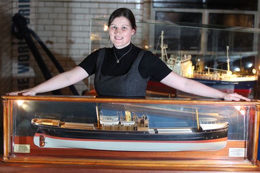
Eibhlin Roche - Guinness Archivist, Guinness Storehouse with the model of the W.M. Barkley. Photo: Jason Clarke Photography

Ninety four years ago on the dark night of October 12th 1917 the W.M.Barkley was torpedoed without warning by the German submarine UC-75. Within minutes the ship, which was owned and operated by the Guinness Company of Dublin, broke in two and sank, taking with her to the bottom four men including her Captain and leaving the rest of her crew to face the sea in an open lifeboat. Now, the darkness where the ship has lain in pieces has been disturbed, probed by fingers of sound that are mapping the seabed in incredible details and bringing to light the position of this famous Irish shipwreck.

"As the first Guinness owned ship, the W.M. Barkley played an important role in the story of the transportation of GUINNESS beer overseas," said Eibhlin Roche, Guinness Archivist. The events of the night of 12th October 1917 are very much part of the history of Guinness that is recorded in the Guinness Archive. It is exciting to finally know the exact resting place of the W.M. Barkley."

A scale model of the W.M. Barkley is on display in the Transport Gallery of Guinness Storehouse remembering the lives of the Guinness men who both perished and survived the events of 12th October 1917. These are stories of tragedy and bravery portraying Irish traditional values, and how they were brought to light with the application of cutting-edge technology.

Koen_Verbruggen_Minister_Rabbitte_Dr_Peter_Heffernan_Eibhlin_Roche_and_David_Smith

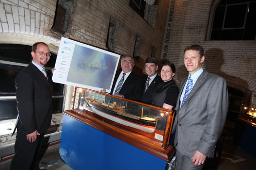
Koen Verbruggen (GSI), Minister Pat Rabbitte, Dr. Peter Heffernan (CEO, Marine Institute), Eibhlin Roche (Guinness Archivist, Guinness Storehouse) and David Smith (Country Director, Diageo Ireland) Photo: Jason Clarke Photography


Published in Marine Science
Amongst the festival tallships lining Waterford quays, the RV Keary, a marine research survey vessel that mapped the estuary in advance of the tall ships arrival, will too be open to the public, writes Jehan Ashmore.
Work to map the navigational channel of Waterford Harbour's estuary was completed last month by the catamaran hulled craft that belongs to the Geological Survey of Ireland (GSI). Her smaller fleetmate the 7.5m RIB RV Geo carried-out work in the shallower areas along the river banks. For images of the seabed survey click HERE. The survey which had started in April was a joint research programme between (GSI) and the Marine Institute (MI).

This was the RV Keary's first INFOMAR survey leg of 2011 and it was also the first time that both vessels have worked in tandem. The mapping of the estuary was from an area just west of the city's Rice Bridge to the open sea at the mouth of Waterford Harbour.

The estuary was mapped before in 2007 using the Marine Institutes larger vessel the RV Celtic Voyager, which covered the harbour approaches from the 10m contour to greater depth offshore. Both RV Keary and RV Geo overlapped their coverage with this previous data, producing a comprehensive and seamless seabed map of the area.

RV Keary is constructed of marine grade aluminium and was custom built in 2008 for the (GSI) by Veecraft Marine of Capetown, South Africa.
The 15m craft with a draft of just 2m is equipped with an extensive range of highly sophisticated technology. She has an open working area at the aft-deck to conduct operations and is licensed to carry up to 12 personnel. For further vessel characteristics click HERE.

The 34-tonne craft made her 7,000 mile delivery voyage from the African continent to Europe. She was firstly transported on the deck of a cargoship to Rotterdam. After unloading at the Dutch port the 22-knot capable craft set off with several calls along the UK south coast to include loading bunkers before finally reaching Dun Laoghaire, from where she entered service in April 2009.

Published in Marine Science

Following the publication of 'The Real Map of Ireland', showing a three-dimensional overview of Ireland's seabed territory, earlier this year comes 'The Real Atlas' – a detailed compilation of stunning three-dimensional imagery featuring the submarine canyons, underwater mountains and abyssal plains that make up Ireland's seabed territory, an area ten times that of our land mass.

This publication, Atlas of the Deep Water Seabed, Ireland was unveiled today (Wednesday 3rdth November) by Minister of State at the Department of Communications, Energy and Natural Resources, Mr. Conor Lenihan, T.D. at the Geoscience 2010 conference in Dublin Castle. It has been compiled by University College, Cork from data gathered as part of the Irish National Seabed Survey (INSS) and INFOMAR inshore seabed survey undertaken by the Geological Survey of Ireland (GSI) the Marine Institute and partners,

Speaking at the opening of the event Minister Lenihan said, "This is the first such Atlas of its kind world-wide, reflecting our leading role in this field. It will be a valuable resource as we seek to utilise our vast ocean resources in the years ahead. As we develop ocean energy, offshore wind and further oil and gas prospecting, an accurate map of the deep seabed will be vital."

The first day of the conference focused on what has been described by European Commissioner for Research, Innovation and Science, Maire Geoghegan-Quinn as one of the "grand challenges for the 21st Century" – the seas and oceans. It featured detailed papers on seabed mapping, deepwater coral reefs, deepwater remotely operated vehicles and a virtual computer simulation of Galway Bay.

3D image of the 300 km-long Gollum Channel system off the Porcupine Seabight, extending from the edge of the Seabight right down to the Porcupine Abyssal Plain.Image by B. Dorschel with kind permission from Springer Science+Business Media B.V.

First day speakers from the Marine Institute included Fabio Sacchetti, who described the mapping of the Rockall Trough, and Tommy Furey who discussed the value of seabed mapping projects to a wide variety of marine industries. The first day's proceedings also included a paper by Dr Colm Lordan of the Marine Institute's Fisheries Science Services team on the value of the INFOMAR seabed survey to the Irish fishing industry, and an important paper by the Marine Institute's Director of Strategic Planning and Development Services, Yvonne Shields entitled "Irish Marine research in the Bigger Picture."

The second day of the conference, will focus on more terrestrial themes includes papers on new findings in relation to Irish offshore basins from researchers at UCD.

Full details of the event, including the programme of speakers, are available from:

http://www.gsi.ie/Geoscience+Initiatives/Geoscience+2010+Conference.htm

Atlas of the Deep Water Seabed, Ireland can be ordered directly from amazon.co.uk at:

http://www.amazon.co.uk/s/ref=nb_sb_noss?url=search-alias%3Dstripbooks&field-keywords=Atlas+of+the+Deep+Water+Seabed%2C+Ireland&x=18&y=19


Published in Marine Science
Page 5 of 5

Ireland's offshore islands

Around 30 of Ireland's offshore islands are inhabited and hold a wealth of cultural heritage.

A central Government objective is to ensure that sustainable vibrant communities continue to live on the islands.

Irish offshore islands FAQs

Technically, it is Ireland itself, as the third largest island in Europe.

Ireland is surrounded by approximately 80 islands of significant size, of which only about 20 are inhabited.

Achill island is the largest of the Irish isles with a coastline of almost 80 miles and has a population of 2,569.

The smallest inhabited offshore island is Inishfree, off Donegal.

The total voting population in the Republic's inhabited islands is just over 2,600 people, according to the Department of Housing.

Starting with west Cork, and giving voting register numbers as of 2020, here you go - Bere island (177), Cape Clear island (131),Dursey island (6), Hare island (29), Whiddy island (26), Long island, Schull (16), Sherkin island (95). The Galway islands are Inis Mór (675), Inis Meáin (148), Inis Oírr (210), Inishbofin (183). The Donegal islands are Arranmore (513), Gola (30), Inishboffin (63), Inishfree (4), Tory (140). The Mayo islands, apart from Achill which is connected by a bridge, are Clare island (116), Inishbiggle (25) and Inishturk (52).

No, the Gaeltacht islands are the Donegal islands, three of the four Galway islands (Inishbofin, like Clifden, is English-speaking primarily), and Cape Clear or Oileán Chléire in west Cork.

Lack of a pier was one of the main factors in the evacuation of a number of islands, the best known being the Blasket islands off Kerry, which were evacuated in November 1953. There are now three cottages available to rent on the Great Blasket island.

In the early 20th century, scholars visited the Great Blasket to learn Irish and to collect folklore and they encouraged the islanders to record their life stories in their native tongue. The three best known island books are An tOileánach (The Islandman) by Tomás Ó Criomhthain, Peig by Peig Sayers, and Fiche Blian ag Fás (Twenty Years A-Growing) by Muiris Ó Súilleabháin. Former taoiseach Charles J Haughey also kept a residence on his island, Inishvickillaune, which is one of the smaller and less accessible Blasket islands.

Charles J Haughey, as above, or late Beatle musician, John Lennon. Lennon bought Dorinish island in Clew Bay, south Mayo, in 1967 for a reported £1,700 sterling. Vendor was Westport Harbour Board which had used it for marine pilots. Lennon reportedly planned to spend his retirement there, and The Guardian newspaper quoted local estate agent Andrew Crowley as saying he was "besotted with the place by all accounts". He did lodge a planning application for a house, but never built on the 19 acres. He offered it to Sid Rawle, founder of the Digger Action Movement and known as the "King of the Hippies". Rawle and 30 others lived there until 1972 when their tents were burned by an oil lamp. Lennon and Yoko Ono visited it once more before his death in 1980. Ono sold the island for £30,000 in 1984, and it is widely reported that she donated the proceeds of the sale to an Irish orphanage


Yes, Rathlin island, off Co Antrim's Causeway Coast, is Ireland's most northerly inhabited island. As a special area of conservation, it is home to tens of thousands of sea birds, including puffins, kittiwakes, razorbills and guillemots. It is known for its Rathlin golden hare. It is almost famous for the fact that Robert the Bruce, King of Scots, retreated after being defeated by the English at Perth and hid in a sea cave where he was so inspired by a spider's tenacity that he returned to defeat his enemy.

No. The Aran islands have a regular ferry and plane service, with ferries from Ros-a-Mhíl, south Connemara all year round and from Doolin, Co Clare in the tourist season. The plane service flies from Indreabhán to all three islands. Inishbofin is connected by ferry from Cleggan, Co Galway, while Clare island and Inishturk are connected from Roonagh pier, outside Louisburgh. The Donegal islands of Arranmore and Tory island also have ferry services, as has Bere island, Cape Clear and Sherkin off Cork. How are the island transport services financed? The Government subsidises transport services to and from the islands. The Irish Coast Guard carries out medical evacuations, as to the RNLI lifeboats. Former Fianna Fáíl minister Éamon Ó Cuív is widely credited with improving transport services to and from offshore islands, earning his department the nickname "Craggy island".

Craggy Island is an bleak, isolated community located of the west coast, inhabited by Irish, a Chinese community and one Maori. Three priests and housekeeper Mrs Doyle live in a parochial house There is a pub, a very small golf course, a McDonald's fast food restaurant and a Chinatown... Actually, that is all fiction. Craggy island is a figment of the imagination of the Father Ted series writers Graham Linehan and Arthur Mathews, for the highly successful Channel 4 television series, and the Georgian style parochial house on the "island" is actually Glenquin House in Co Clare.

Yes, that is of the Plassey, a freighter which was washed up on Inis Oírr in bad weather in 1960.

There are some small privately owned islands,and islands like Inishlyre in Co Mayo with only a small number of residents providing their own transport. Several Connemara islands such as Turbot and Inishturk South have a growing summer population, with some residents extending their stay during Covid-19. Turbot island off Eyrephort is one such example – the island, which was first spotted by Alcock and Brown as they approached Ireland during their epic transatlantic flight in 1919, was evacuated in 1978, four years after three of its fishermen drowned on the way home from watching an All Ireland final in Clifden. However, it is slowly being repopulated

Responsibility for the islands was taking over by the Department of Rural and Community Development . It was previously with the Gaeltacht section in the Department of Media, Tourism, Arts, Culture, Sport and the Gaeltacht.

It is a periodic bone of contention, as Ireland does not have the same approach to its islands as Norway, which believes in right of access. However, many improvements were made during Fianna Fáíl Galway West TD Éamon Ó Cuív's time as minister. The Irish Island Federation, Comdháil Oileáin na hÉireann, represents island issues at national and international level.

The 12 offshore islands with registered voters have long argued that having to cast their vote early puts them at a disadvantage – especially as improved transport links mean that ballot boxes can be transported to the mainland in most weather conditions, bar the winter months. Legislation allowing them to vote on the same day as the rest of the State wasn't passed in time for the February 2020 general election.

Yes, but check tide tables ! Omey island off north Connemara is accessible at low tide and also runs a summer race meeting on the strand. In Sligo, 14 pillars mark the way to Coney island – one of several islands bearing this name off the Irish coast.

Cape Clear or Oileán Chléire is the country's most southerly inhabited island, eight miles off the west Cork coast, and within sight of the Fastnet Rock lighthouse, also known as the "teardrop of Ireland".
Skellig Michael off the Kerry coast, which has a monastic site dating from the 6th century. It is accessible by boat – prebooking essential – from Portmagee, Co Kerry. However, due to Covid-19 restrictions, it was not open to visitors in 2020.
All islands have bird life, but puffins and gannets and kittiwakes are synonymous with Skellig Michael and Little Skellig. Rathlin island off Antrim and Cape Clear off west Cork have bird observatories. The Saltee islands off the Wexford coast are privately owned by the O'Neill family, but day visitors are permitted access to the Great Saltee during certain hours. The Saltees have gannets, gulls, puffins and Manx shearwaters.
Vikings used Dublin as a European slaving capital, and one of their bases was on Dalkey island, which can be viewed from Killiney's Vico road. Boat trips available from Coliemore harbour in Dalkey. Birdwatch Ireland has set up nestboxes here for roseate terns. Keep an eye out also for feral goats.
Plenty! There are regular boat trips in summer to Inchagoill island on Lough Corrib, while the best known Irish inshore island might be the lake isle of Innisfree on Sligo's Lough Gill, immortalised by WB Yeats in his poem of the same name. Roscommon's Lough Key has several islands, the most prominent being the privately-owned Castle Island. Trinity island is more accessible to the public - it was once occupied by Cistercian monks from Boyle Abbey.

©Afloat 2020