Menu

Ireland's sailing, boating & maritime magazine

Displaying items by tag: Maritime Planning

There will be “no hierarchy” of access to Ireland’s sea areas under its new maritime licensing system, the head of the new Maritime Area Regulatory Authority (MARA) has said.

MARA chief executive officer Laura Brien was speaking at the third annual seafarers’ conference hosted by the National Maritime College of Ireland in Limerick.

Brien also said that other European countries would “kill to have the space” that Ireland enjoys around its coastline.

She was responding to concerns about “spatial squeeze” raised at the conference, held in Limerick on the eve of the Skipper Expo.

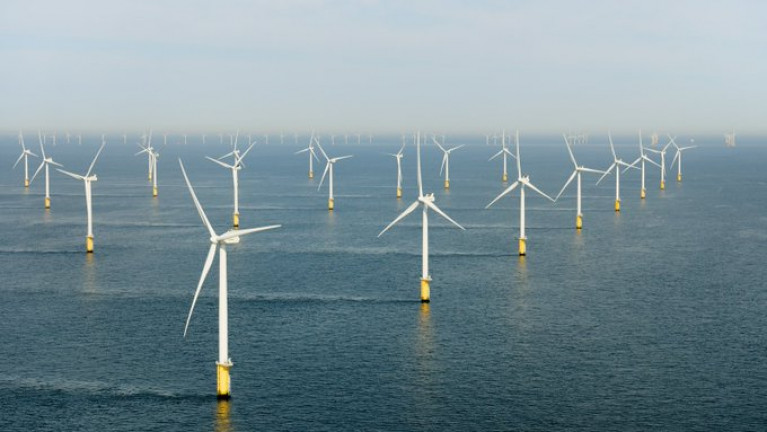
Brien said that MARA’s remit was not just about offshore renewable energy (ORE), and licensing it has to approve extends from telecom cables to coastal erosion work to port development.

While there were also concerns that Ireland was lagging behind other countries in ORE development, “the upside to Ireland being late to the party is that…we’ve an awful lot of people to learn from”, including Scotland.

Asked to define "what success would look like" for MARA in ten years' time – a theme of the panel discussion she was participating in – Brien said that she hoped the opportunity would be taken early on to monitor the impact of offshore wind.

“We don’t know about a lot of the impacts of ORE..and we have the opportunity to put in place monitoring of the impact, so that when we get to 2034 we have ten years of data which would provide a solid evidence base for consenting," she said.

Capt Robert McCabe, chair of the national seafood/ORE working group, said that there were many challenges but progress was being made, and all involved were “committed to trying to find resolutions”.

Among issues being discussed was the need for a data hub, as in a one-stop shop for information, while evidence of activity by inshore vessels was also very important in making a case for impact of ORE.

Published in Marine Planning
Tagged under

A Govenment maritime planning regime is being announced, which will enable the development of offshore wind farms

Offshore wind farms are needed if Ireland is to achieve its climate targets and reduce dependence on imported gas and oil.

The Government has pointed to renewable energy as a way to increase energy security and its climate action plan set a target of at least 5GW of power from offshore wind farms by 2030 - greater than Ireland's current total wind capacity.

Those wind farms will need planning permission and the first phase of that will be to get a Marine Area Consent.

There are seven proposed wind farms with a combined capacity of around 3GW in the first batch to be considered. Six are off the east coast and one is off the coast of Conamara (Connemara).

Minister for the Environment, Climate and Communications Eamon Ryan will issue the consents, which are expected to happen in the second half of this year.

The Maritime Area Planning Agency (MARA) as Afloat reported last year, should be established by early next year when it will take responsibility for the area.

See also related launch of Maritime Planning Bill by the Taoiseach at Dun Laoghaire Harbour last year at the Irish Lights head quarters. 

More available on the new agency from RTE News

The headquarters for the new national maritime body, MARA, Afloat adds is to be based out of a new re-development at Trinity Wharf on Wexford's southern quays. 

Published in Power From the Sea

The Maritime Area Planning Bill 2021 and accompanying Explanatory Memorandum have been published today by the Department of Housing, Local Government and Heritage.

The publication was approved at Cabinet on 29th June 2021 and confirmed by An Taoiseach Michéal Martin TD on 1st July 2021, alongside Ministers Darragh O’Brien TD, Eamon Ryan TD and Peter Burke TD when they launched previously at the Commissioners for Irish Lights Headquarters in Dún Laoghaire Harbour.

This legislation intends to put in place a comprehensive and coherent planning system for the entire Maritime Area. The constituent elements of this system are:

• A forward planning regime for the maritime area;

• A new streamlined development management system for the maritime area incorporating consenting for the occupation of the maritime area (Maritime Area Consents and licencing) and a new planning consenting regime (to be implemented by coastal local authorities and An Bord Pleanála);

• The establishment of a new agency, the Maritime Area Regulatory Authority (MARA) to manage the occupation of the maritime area and to enforce the provisions of the new regime.

Commenting on the Maritime Area Planning Bill, the Minister for Housing, Local Government and Heritage, Darragh O’Brien TD, said: “My Department is leading an extensive marine management reform programme, the likes of which the State has never seen. The Maritime Area Planning Bill, which Cabinet has approved, is further evidence of this Government’s intent to modernise the State’s approach to marine management. It will represent a giant leap forward towards meeting our ambitious climate action goals and targets.”

Minister for the Environment, Climate, Communications and Transport, Eamon Ryan TD, said: “Ireland’s ocean area is home to an amazing array of marine life. Our offshore wind resources represent a real opportunity for us to break free from fossil fuels and reach our ambitious climate goals. My department has been closely involved in the development of this legislation, which will create a streamlined planning and consent regime. We are determined that as we develop our resources, we do so in a way that protects and restores our marine environment and its biodiversity.”

Published in Coastal Notes

Ireland's offshore islands

Around 30 of Ireland's offshore islands are inhabited and hold a wealth of cultural heritage.

A central Government objective is to ensure that sustainable vibrant communities continue to live on the islands.

Irish offshore islands FAQs

Technically, it is Ireland itself, as the third largest island in Europe.

Ireland is surrounded by approximately 80 islands of significant size, of which only about 20 are inhabited.

Achill island is the largest of the Irish isles with a coastline of almost 80 miles and has a population of 2,569.

The smallest inhabited offshore island is Inishfree, off Donegal.

The total voting population in the Republic's inhabited islands is just over 2,600 people, according to the Department of Housing.

Starting with west Cork, and giving voting register numbers as of 2020, here you go - Bere island (177), Cape Clear island (131),Dursey island (6), Hare island (29), Whiddy island (26), Long island, Schull (16), Sherkin island (95). The Galway islands are Inis Mór (675), Inis Meáin (148), Inis Oírr (210), Inishbofin (183). The Donegal islands are Arranmore (513), Gola (30), Inishboffin (63), Inishfree (4), Tory (140). The Mayo islands, apart from Achill which is connected by a bridge, are Clare island (116), Inishbiggle (25) and Inishturk (52).

No, the Gaeltacht islands are the Donegal islands, three of the four Galway islands (Inishbofin, like Clifden, is English-speaking primarily), and Cape Clear or Oileán Chléire in west Cork.

Lack of a pier was one of the main factors in the evacuation of a number of islands, the best known being the Blasket islands off Kerry, which were evacuated in November 1953. There are now three cottages available to rent on the Great Blasket island.

In the early 20th century, scholars visited the Great Blasket to learn Irish and to collect folklore and they encouraged the islanders to record their life stories in their native tongue. The three best known island books are An tOileánach (The Islandman) by Tomás Ó Criomhthain, Peig by Peig Sayers, and Fiche Blian ag Fás (Twenty Years A-Growing) by Muiris Ó Súilleabháin. Former taoiseach Charles J Haughey also kept a residence on his island, Inishvickillaune, which is one of the smaller and less accessible Blasket islands.

Charles J Haughey, as above, or late Beatle musician, John Lennon. Lennon bought Dorinish island in Clew Bay, south Mayo, in 1967 for a reported £1,700 sterling. Vendor was Westport Harbour Board which had used it for marine pilots. Lennon reportedly planned to spend his retirement there, and The Guardian newspaper quoted local estate agent Andrew Crowley as saying he was "besotted with the place by all accounts". He did lodge a planning application for a house, but never built on the 19 acres. He offered it to Sid Rawle, founder of the Digger Action Movement and known as the "King of the Hippies". Rawle and 30 others lived there until 1972 when their tents were burned by an oil lamp. Lennon and Yoko Ono visited it once more before his death in 1980. Ono sold the island for £30,000 in 1984, and it is widely reported that she donated the proceeds of the sale to an Irish orphanage


Yes, Rathlin island, off Co Antrim's Causeway Coast, is Ireland's most northerly inhabited island. As a special area of conservation, it is home to tens of thousands of sea birds, including puffins, kittiwakes, razorbills and guillemots. It is known for its Rathlin golden hare. It is almost famous for the fact that Robert the Bruce, King of Scots, retreated after being defeated by the English at Perth and hid in a sea cave where he was so inspired by a spider's tenacity that he returned to defeat his enemy.

No. The Aran islands have a regular ferry and plane service, with ferries from Ros-a-Mhíl, south Connemara all year round and from Doolin, Co Clare in the tourist season. The plane service flies from Indreabhán to all three islands. Inishbofin is connected by ferry from Cleggan, Co Galway, while Clare island and Inishturk are connected from Roonagh pier, outside Louisburgh. The Donegal islands of Arranmore and Tory island also have ferry services, as has Bere island, Cape Clear and Sherkin off Cork. How are the island transport services financed? The Government subsidises transport services to and from the islands. The Irish Coast Guard carries out medical evacuations, as to the RNLI lifeboats. Former Fianna Fáíl minister Éamon Ó Cuív is widely credited with improving transport services to and from offshore islands, earning his department the nickname "Craggy island".

Craggy Island is an bleak, isolated community located of the west coast, inhabited by Irish, a Chinese community and one Maori. Three priests and housekeeper Mrs Doyle live in a parochial house There is a pub, a very small golf course, a McDonald's fast food restaurant and a Chinatown... Actually, that is all fiction. Craggy island is a figment of the imagination of the Father Ted series writers Graham Linehan and Arthur Mathews, for the highly successful Channel 4 television series, and the Georgian style parochial house on the "island" is actually Glenquin House in Co Clare.

Yes, that is of the Plassey, a freighter which was washed up on Inis Oírr in bad weather in 1960.

There are some small privately owned islands,and islands like Inishlyre in Co Mayo with only a small number of residents providing their own transport. Several Connemara islands such as Turbot and Inishturk South have a growing summer population, with some residents extending their stay during Covid-19. Turbot island off Eyrephort is one such example – the island, which was first spotted by Alcock and Brown as they approached Ireland during their epic transatlantic flight in 1919, was evacuated in 1978, four years after three of its fishermen drowned on the way home from watching an All Ireland final in Clifden. However, it is slowly being repopulated

Responsibility for the islands was taking over by the Department of Rural and Community Development . It was previously with the Gaeltacht section in the Department of Media, Tourism, Arts, Culture, Sport and the Gaeltacht.

It is a periodic bone of contention, as Ireland does not have the same approach to its islands as Norway, which believes in right of access. However, many improvements were made during Fianna Fáíl Galway West TD Éamon Ó Cuív's time as minister. The Irish Island Federation, Comdháil Oileáin na hÉireann, represents island issues at national and international level.

The 12 offshore islands with registered voters have long argued that having to cast their vote early puts them at a disadvantage – especially as improved transport links mean that ballot boxes can be transported to the mainland in most weather conditions, bar the winter months. Legislation allowing them to vote on the same day as the rest of the State wasn't passed in time for the February 2020 general election.

Yes, but check tide tables ! Omey island off north Connemara is accessible at low tide and also runs a summer race meeting on the strand. In Sligo, 14 pillars mark the way to Coney island – one of several islands bearing this name off the Irish coast.

Cape Clear or Oileán Chléire is the country's most southerly inhabited island, eight miles off the west Cork coast, and within sight of the Fastnet Rock lighthouse, also known as the "teardrop of Ireland".
Skellig Michael off the Kerry coast, which has a monastic site dating from the 6th century. It is accessible by boat – prebooking essential – from Portmagee, Co Kerry. However, due to Covid-19 restrictions, it was not open to visitors in 2020.
All islands have bird life, but puffins and gannets and kittiwakes are synonymous with Skellig Michael and Little Skellig. Rathlin island off Antrim and Cape Clear off west Cork have bird observatories. The Saltee islands off the Wexford coast are privately owned by the O'Neill family, but day visitors are permitted access to the Great Saltee during certain hours. The Saltees have gannets, gulls, puffins and Manx shearwaters.
Vikings used Dublin as a European slaving capital, and one of their bases was on Dalkey island, which can be viewed from Killiney's Vico road. Boat trips available from Coliemore harbour in Dalkey. Birdwatch Ireland has set up nestboxes here for roseate terns. Keep an eye out also for feral goats.
Plenty! There are regular boat trips in summer to Inchagoill island on Lough Corrib, while the best known Irish inshore island might be the lake isle of Innisfree on Sligo's Lough Gill, immortalised by WB Yeats in his poem of the same name. Roscommon's Lough Key has several islands, the most prominent being the privately-owned Castle Island. Trinity island is more accessible to the public - it was once occupied by Cistercian monks from Boyle Abbey.

©Afloat 2020