Menu

Ireland's sailing, boating & maritime magazine

Displaying items by tag: windsurf

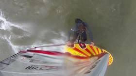
Tom Harrison (42) from Burnham-on-Crouch, Essex has reached the final stages of his preparations to windsurf 75 nautical miles to raise funds for the British Dyslexia Association and the RNLI. He hopes to raise a total of £10,000 for each nominated charity writes Sue Pelling

Despite his lifelong battle with dyslexia, Harrison has built a successful career as a boatbuilder, and fine jewellery designer/manufacturer. He is now keen to demonstrate to others who suffer from similar debilitating conditions, that by setting a personal challenge it is possible to find the strength, determination and the ability to see the positive side of seemingly daunting prospects.

Commenting on his decision to embark on such a challenge, Harrison said: “I once joined a pilgrimage to Lourdes, France to help the sick and disabled. It was a humbling and rewarding experience. And I wish to continue along this vein. Hence I have chosen my windsurf challenge to continue what I believe in.

“I am not doing this challenge to prove anything to the doubters and the ‘no’ people, I am here to celebrate the ‘yes’ people and the ‘you can’ and ‘do yourself proud’ people.”

After two years of planning, training, and raising funds for equipment, Harrison believes ‘the time is right’ and he hopes to attempt the challenge in July or August this year, depending on the weather conditions.

To complete the 75nm course on his custom-built carbonfibre board and Severne sail, in his target time of five hours, Harrison says he’ll need to clock up an average speed of 15kts, which means he’ll need a steady southerly breeze of 15-18kts.

Sailing across the North Sea from Burnham-on-Crouch (Swin Spitway) to Ostend, is no mean feat. Harrison will face many challenges along the way including biggest hazard of all – shipping. The Channel, which flows into the North Sea in this area, is one of the busiest shipping lanes in the world, so it will be down to Harrison and his support team on the accompanying Rigid Inflatable Boat (RIB) Restless, to work out a safe route through.

Thankfully, Team North Sea Challenge is well equipped with modern marine technology including Sci-Tech (POB) Tracker, which tracks in real time, independently of phone networks, using GNSS and RF technology. Communication between the support crew and Harrison will be via hand held VHF radios, and AIS (Automatic Identification System) to alert shipping, will be in use.

Commenting on his training and the level of fitness he has built up, to date, Harrison concluded: “I have been training for this for two years but with under three months to go, I have increased the intensity. I spend between one-two hours in the gym four or five days a week, as well as yoga every morning and as much on-the-water training as possible. My sailing sessions last anything between two and four hours, so it is full on.”

To follow the progress of Harrison’s North Sea Challenge, go to www.tomharrisonnorthseachallenge.com. There will also be constant news updates on Facebook (Tom Harrison North Sea Challenge) and Twitter (Thomas Harrison@tomwindsurfing).

To help raise funds for Harrison’s chosen charities – RNLI and British Dyslexia Association

About Tom Harrison

Tom Harrison (42) lives and works in Burnham-on-Crouch and runs his own design and manufacturing company specialising in fine jewellery. Although dyslexia has threatened to disrupt his life, his will power and passion for sailing, in particular, has helped him conquer personal challenges including his attempt at the North Sea Challenge. With the support of his family, friends and partner Jo, Harrison’s aim, in addition to raising funds for two charities, is to leave a lasting legacy to help inspire those suffering similar disabilities, to live their dreams.

Published in News Update
Tagged under

The Irish GPS Speedsailing record fell again last Friday in Dungarvan when Oisin Van Gelderen broke all previous speeds, becoming the fastest sailor ever to sail on Irish waters.

The speed is ratified by the WGPSSRC (World GPS Speedsailing Records Council):  
http://www.gps-speedsurfing.com/default.aspx?mnu=records, who issue GPS records based on the best 10 second run of 45.02 knots, and a distance travelled of around 270 metres in this time.

The 5 x 10second run average, currently puts him in fourth overall on the 2011 GPS speed ranking list and 23rd overall in the all time rankings.
Peak speed for the day was 46.32 knots (84 kmph), and 500m speed was 43.96knots.

Even though Van Gelderen broke the late John Kenny's 500m speed, he retains that title for now, as the WSSRC (World Speed sailing Records Council) issue National records for that distance, and do not yet recognize GPS.

The rise in popularity in GPS speedsailing has made the competition a worldwide phenomenon, as people from different countries compete year round to push their personal and international speeds. Over 4000 members subscribe to the gps-speedsurfing.com website.

Published in News Update

Ireland's offshore islands

Around 30 of Ireland's offshore islands are inhabited and hold a wealth of cultural heritage.

A central Government objective is to ensure that sustainable vibrant communities continue to live on the islands.

Irish offshore islands FAQs

Technically, it is Ireland itself, as the third largest island in Europe.

Ireland is surrounded by approximately 80 islands of significant size, of which only about 20 are inhabited.

Achill island is the largest of the Irish isles with a coastline of almost 80 miles and has a population of 2,569.

The smallest inhabited offshore island is Inishfree, off Donegal.

The total voting population in the Republic's inhabited islands is just over 2,600 people, according to the Department of Housing.

Starting with west Cork, and giving voting register numbers as of 2020, here you go - Bere island (177), Cape Clear island (131),Dursey island (6), Hare island (29), Whiddy island (26), Long island, Schull (16), Sherkin island (95). The Galway islands are Inis Mór (675), Inis Meáin (148), Inis Oírr (210), Inishbofin (183). The Donegal islands are Arranmore (513), Gola (30), Inishboffin (63), Inishfree (4), Tory (140). The Mayo islands, apart from Achill which is connected by a bridge, are Clare island (116), Inishbiggle (25) and Inishturk (52).

No, the Gaeltacht islands are the Donegal islands, three of the four Galway islands (Inishbofin, like Clifden, is English-speaking primarily), and Cape Clear or Oileán Chléire in west Cork.

Lack of a pier was one of the main factors in the evacuation of a number of islands, the best known being the Blasket islands off Kerry, which were evacuated in November 1953. There are now three cottages available to rent on the Great Blasket island.

In the early 20th century, scholars visited the Great Blasket to learn Irish and to collect folklore and they encouraged the islanders to record their life stories in their native tongue. The three best known island books are An tOileánach (The Islandman) by Tomás Ó Criomhthain, Peig by Peig Sayers, and Fiche Blian ag Fás (Twenty Years A-Growing) by Muiris Ó Súilleabháin. Former taoiseach Charles J Haughey also kept a residence on his island, Inishvickillaune, which is one of the smaller and less accessible Blasket islands.

Charles J Haughey, as above, or late Beatle musician, John Lennon. Lennon bought Dorinish island in Clew Bay, south Mayo, in 1967 for a reported £1,700 sterling. Vendor was Westport Harbour Board which had used it for marine pilots. Lennon reportedly planned to spend his retirement there, and The Guardian newspaper quoted local estate agent Andrew Crowley as saying he was "besotted with the place by all accounts". He did lodge a planning application for a house, but never built on the 19 acres. He offered it to Sid Rawle, founder of the Digger Action Movement and known as the "King of the Hippies". Rawle and 30 others lived there until 1972 when their tents were burned by an oil lamp. Lennon and Yoko Ono visited it once more before his death in 1980. Ono sold the island for £30,000 in 1984, and it is widely reported that she donated the proceeds of the sale to an Irish orphanage


Yes, Rathlin island, off Co Antrim's Causeway Coast, is Ireland's most northerly inhabited island. As a special area of conservation, it is home to tens of thousands of sea birds, including puffins, kittiwakes, razorbills and guillemots. It is known for its Rathlin golden hare. It is almost famous for the fact that Robert the Bruce, King of Scots, retreated after being defeated by the English at Perth and hid in a sea cave where he was so inspired by a spider's tenacity that he returned to defeat his enemy.

No. The Aran islands have a regular ferry and plane service, with ferries from Ros-a-Mhíl, south Connemara all year round and from Doolin, Co Clare in the tourist season. The plane service flies from Indreabhán to all three islands. Inishbofin is connected by ferry from Cleggan, Co Galway, while Clare island and Inishturk are connected from Roonagh pier, outside Louisburgh. The Donegal islands of Arranmore and Tory island also have ferry services, as has Bere island, Cape Clear and Sherkin off Cork. How are the island transport services financed? The Government subsidises transport services to and from the islands. The Irish Coast Guard carries out medical evacuations, as to the RNLI lifeboats. Former Fianna Fáíl minister Éamon Ó Cuív is widely credited with improving transport services to and from offshore islands, earning his department the nickname "Craggy island".

Craggy Island is an bleak, isolated community located of the west coast, inhabited by Irish, a Chinese community and one Maori. Three priests and housekeeper Mrs Doyle live in a parochial house There is a pub, a very small golf course, a McDonald's fast food restaurant and a Chinatown... Actually, that is all fiction. Craggy island is a figment of the imagination of the Father Ted series writers Graham Linehan and Arthur Mathews, for the highly successful Channel 4 television series, and the Georgian style parochial house on the "island" is actually Glenquin House in Co Clare.

Yes, that is of the Plassey, a freighter which was washed up on Inis Oírr in bad weather in 1960.

There are some small privately owned islands,and islands like Inishlyre in Co Mayo with only a small number of residents providing their own transport. Several Connemara islands such as Turbot and Inishturk South have a growing summer population, with some residents extending their stay during Covid-19. Turbot island off Eyrephort is one such example – the island, which was first spotted by Alcock and Brown as they approached Ireland during their epic transatlantic flight in 1919, was evacuated in 1978, four years after three of its fishermen drowned on the way home from watching an All Ireland final in Clifden. However, it is slowly being repopulated

Responsibility for the islands was taking over by the Department of Rural and Community Development . It was previously with the Gaeltacht section in the Department of Media, Tourism, Arts, Culture, Sport and the Gaeltacht.

It is a periodic bone of contention, as Ireland does not have the same approach to its islands as Norway, which believes in right of access. However, many improvements were made during Fianna Fáíl Galway West TD Éamon Ó Cuív's time as minister. The Irish Island Federation, Comdháil Oileáin na hÉireann, represents island issues at national and international level.

The 12 offshore islands with registered voters have long argued that having to cast their vote early puts them at a disadvantage – especially as improved transport links mean that ballot boxes can be transported to the mainland in most weather conditions, bar the winter months. Legislation allowing them to vote on the same day as the rest of the State wasn't passed in time for the February 2020 general election.

Yes, but check tide tables ! Omey island off north Connemara is accessible at low tide and also runs a summer race meeting on the strand. In Sligo, 14 pillars mark the way to Coney island – one of several islands bearing this name off the Irish coast.

Cape Clear or Oileán Chléire is the country's most southerly inhabited island, eight miles off the west Cork coast, and within sight of the Fastnet Rock lighthouse, also known as the "teardrop of Ireland".
Skellig Michael off the Kerry coast, which has a monastic site dating from the 6th century. It is accessible by boat – prebooking essential – from Portmagee, Co Kerry. However, due to Covid-19 restrictions, it was not open to visitors in 2020.
All islands have bird life, but puffins and gannets and kittiwakes are synonymous with Skellig Michael and Little Skellig. Rathlin island off Antrim and Cape Clear off west Cork have bird observatories. The Saltee islands off the Wexford coast are privately owned by the O'Neill family, but day visitors are permitted access to the Great Saltee during certain hours. The Saltees have gannets, gulls, puffins and Manx shearwaters.
Vikings used Dublin as a European slaving capital, and one of their bases was on Dalkey island, which can be viewed from Killiney's Vico road. Boat trips available from Coliemore harbour in Dalkey. Birdwatch Ireland has set up nestboxes here for roseate terns. Keep an eye out also for feral goats.
Plenty! There are regular boat trips in summer to Inchagoill island on Lough Corrib, while the best known Irish inshore island might be the lake isle of Innisfree on Sligo's Lough Gill, immortalised by WB Yeats in his poem of the same name. Roscommon's Lough Key has several islands, the most prominent being the privately-owned Castle Island. Trinity island is more accessible to the public - it was once occupied by Cistercian monks from Boyle Abbey.

©Afloat 2020