


Displaying items by tag: Hydroacoustic Survey
#MarineScience - Researchers at NUI Galway, along with partners at the Irish Centre for Research in Applied Geosciences (iCRAG) and the Marine Institute, are currently carrying out a marine hydroacoustic survey in the eastern margin of the Porcupine Basin.
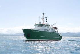
Continuing till this Saturday 16 June, the project conducted from the RV Celtic Voyager (Callsign EIQN) involves generating an acoustic sound source (seismic airgun) adjacent to a short-term deployment of a hydrophone mooring and drifter array in order to investigate noise propagation across the Irish continental margin. The project is planned to inform research into noise pollution as part of Ireland’s obligations under the Marine Strategy Framework Directive (MSFD).
Approximate locations of fixed moorings and seismic noise transect are included in Marine Notice No 24 of 2018, a PDF of which is available to read or download HERE.
Fixed moorings will include yellow surface buoys with warning lights: high intensity, quick flash, continuous, yellow. The drifter will include a yellow surface buoy with nav light: 5 flashes every 20 seconds, yellow, 2nm distance.
The RV Celtic Voyager is displaying appropriate lights and signals and will be within the vicinity at all times throughout the survey.
Researchers also emphasise that the closest distance from survey to any marine SAC is over 16 nautical miles. Commercial fishing and other marine operators are requested to keep a 3nm distance from any survey instrument moorings, and to keep a 2nm distance around the entire survey area clear of any gear or apparatus during the survey period outlined above.


 for a “Student Safe” water safety")


 for the new skiff and builder Patsy Whelan Jnr.")


 with his exuberant crew as they celebrate being overall winners of Howth Wave 2024")
