Menu

Ireland's sailing, boating & maritime magazine

Displaying items by tag: Geological Survey of Ireland

Mapping Ireland’s seabed, how scientists predict flooding and how to grow your own volcano are themes of an open day hosted by the Geological Survey of Ireland (GSI) and National Museum of Ireland this weekend.

The free “Down to Earth” open day event takes place on Saturday next, May 7th, at the National Museum of Ireland - Decorative Arts and History, Collins Barracks, Dublin.

GSI scientists will be on hand to “bring land and seabed mapping to life, to show the importance of groundwater, and reveal the secrets of Irish fossils,” the organisers state.

They will be joined by colleagues from DIAS (Dublin Institute for Advanced Studies), iCRAG (the Science Foundation Ireland research centre in applied sciences), Met Éireann, and Teagasc to answer questions on earthquakes, the metals we need for life, weather and flooding, and soil.

Members of the public are invited to “try and stump the geologist” by bringing a favourite rock or fossil to have it identified by a geology curator from the National Museum of Ireland.

Sustainable arts experts ReCreate will be running workshops for those families who would like to design some geology inspired art.

The open day takes its inspiration from “Down to Earth- Exploring Ireland’s Geology”, which is currently on exhibition.

Booking is not required, and members of the public can drop in to Collins Barracks, Dublin from 11 am on Saturday, May 7th.

Published in Marine Science

#RESEARCH VESSEL CHARTER - The Geological Survey of Ireland (GSI) have chartered the Cosantoir Bradan from the Central Fisheries Board

The fisheries patrol cutter is to be used in conjunction with the RV Keary for survey work, including bottom survey of all coastal regions around Ireland.

The 15m catamaran inshore research vessel is currently undergoing modifications and refurbishing works at Arklow Marine Services yard.

Published in Marine Science
Amongst the festival tallships lining Waterford quays, the RV Keary, a marine research survey vessel that mapped the estuary in advance of the tall ships arrival, will too be open to the public, writes Jehan Ashmore.
Work to map the navigational channel of Waterford Harbour's estuary was completed last month by the catamaran hulled craft that belongs to the Geological Survey of Ireland (GSI). Her smaller fleetmate the 7.5m RIB RV Geo carried-out work in the shallower areas along the river banks. For images of the seabed survey click HERE. The survey which had started in April was a joint research programme between (GSI) and the Marine Institute (MI).

This was the RV Keary's first INFOMAR survey leg of 2011 and it was also the first time that both vessels have worked in tandem. The mapping of the estuary was from an area just west of the city's Rice Bridge to the open sea at the mouth of Waterford Harbour.

The estuary was mapped before in 2007 using the Marine Institutes larger vessel the RV Celtic Voyager, which covered the harbour approaches from the 10m contour to greater depth offshore. Both RV Keary and RV Geo overlapped their coverage with this previous data, producing a comprehensive and seamless seabed map of the area.

RV Keary is constructed of marine grade aluminium and was custom built in 2008 for the (GSI) by Veecraft Marine of Capetown, South Africa.
The 15m craft with a draft of just 2m is equipped with an extensive range of highly sophisticated technology. She has an open working area at the aft-deck to conduct operations and is licensed to carry up to 12 personnel. For further vessel characteristics click HERE.

The 34-tonne craft made her 7,000 mile delivery voyage from the African continent to Europe. She was firstly transported on the deck of a cargoship to Rotterdam. After unloading at the Dutch port the 22-knot capable craft set off with several calls along the UK south coast to include loading bunkers before finally reaching Dun Laoghaire, from where she entered service in April 2009.

Published in Marine Science

Two mussel dredger-trawlers made a rare transit of Dalkey Sound, last Friday, writes Jehan Ashmore.

The sound which is located to the south of Dublin Bay is not used by commercial traffic but is frequented by pleasure-craft, local fishing boats from Dun Laoghaire. In addition to occasional traffic by the Irish Naval Service, Marine Institute research vessel RV Celtic Voyager, the GSI's RV Keary and foreign tall-ships.
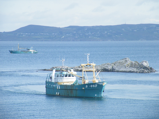
Leading the pair of mussel dredgers was the Belfast registered Mytilus (B-449) named after the mussel species 'Mytilus edulis' and the Wexford registered Branding (WD-4A).
MUSSEL_DREDGERS
Mytilus in Dalkey Sound and in the backround Branding approaches from
Dublin Bay. Photo Jehan Ashmore/ShipSNAPS

The vessels were making a southerly direction as they headed across Dublin Bay towards Dalkey Island. Mytilus lowered a mussel cage bucket into the sound which was dragged on two separate occasions over a short distance running parallel between the island and the coast.

The operation was all too brief as the Mytilus then proceeded into Killiney Bay followed closely astern by Branding. Upon entering the neighbouring bay, both vessels conducted dredging activity before continuing south beyond Bray Head.

Mussel grounds are located throughout certain hotspots in the Irish Sea and earlier this month, it is reported that there was a notable increase in mussel dredgers in Bangor, Northern Ireland. The dredgers were the Mytilus and Branding which berthed at the Co. Down harbour after a lengthy period of relative inactivity.

Mytilus was built in The Netherlands by Scheepwerf Van Os Yerseke B.V. and appeared in an episode of the successful BBC TV series 'Coast'. At the time of the broadcast she was registered at Beaumaris, Anglesey and was seen working in the northern approaches of the Menai Straits. The fishery grounds are ideally suited for the growing processes required in farmed mussel production.

Branding was also built by a Dutch shipyard, Kooieman in 1988 and her design is typical of the mussel dredgers based in Wexford. The market for mussels is mainly from the northern European countries of Belgium, France and the Netherlands.

Published in Fishing
The Co. Wicklow based Maritime Management has been awarded the ISO 9001 and ISO 14001 accreditation by the international accreditation body Germanischer Lloyd. The award to Maritime Management marks the company as a unique provider of ship management services based
in Ireland.
"These awards show our dedication to delivering high quality ship management services, beyond the strict compliance required in this highly regulated industry," said Jan Berg, managing director of Maritime Management.

"Achieving ISO 14001 accreditation, an internationally recognised green standard, shows our respect of the sensitive marine environment and has been well received by our international and Irish clients. It is of particular significance to our clients involved in underwater exploration and scientific research and those involved in the transport of agricultural produce either refrigerated or in bulk."

Maritime Management has an international client base with a diverse range of vessels. Services include technical, operational and crewing for specialist passenger ships, cargoships, refrigerated cargo ships and specialist vessels such as the exploration vessel EV Nautilus.

The vessel is managed on behalf of the famous undersea explorer Dr. Robert Ballard, who is known best for his discovery of the Titanic, PT 109 and the Bismark. Over the last two years Maritime Management has carried out major work to adapt the vessel to suit the requirements of broadcasters National Geographic and CBS.

The work carried outon the vessel has the ground breaking ability to broadcast live HD video from the ocean floor. This enabled scientific teams from the USA and around the world to interact in real time with the underwater operations. To read more about the work of the EV Nautilus and the mapping of underwater volcanoes, life forms,shipwrecks and more click here.

Maritime Management's projects in Ireland have included the design and construction of the Geological Survey of Ireland (GSI) RV Keary, a small yet high-tech survey vessel which was built in South Africa. The 15m asymmetrical catamaran is constructed of aluminium and has a speed of 15 knots. The craft has a Marine Survey Office P5 license for 12 passengers. For further technical details click here.

Published in Ports & Shipping

The Irish Coast Guard

The Irish Coast Guard is Ireland's fourth 'Blue Light' service (along with An Garda Síochána, the Ambulance Service and the Fire Service). It provides a nationwide maritime emergency organisation as well as a variety of services to shipping and other government agencies.

The purpose of the Irish Coast Guard is to promote safety and security standards, and by doing so, prevent as far as possible, the loss of life at sea, and on inland waters, mountains and caves, and to provide effective emergency response services and to safeguard the quality of the marine environment.

The Irish Coast Guard has responsibility for Ireland's system of marine communications, surveillance and emergency management in Ireland's Exclusive Economic Zone (EEZ) and certain inland waterways.

It is responsible for the response to, and co-ordination of, maritime accidents which require search and rescue and counter-pollution and ship casualty operations. It also has responsibility for vessel traffic monitoring.

Operations in respect of maritime security, illegal drug trafficking, illegal migration and fisheries enforcement are co-ordinated by other bodies within the Irish Government.

On average, each year, the Irish Coast Guard is expected to:

  • handle 3,000 marine emergencies
  • assist 4,500 people and save about 200 lives
  • task Coast Guard helicopters on missions

The Coast Guard has been around in some form in Ireland since 1908.

Coast Guard helicopters

The Irish Coast Guard has contracted five medium-lift Sikorsky Search and Rescue helicopters deployed at bases in Dublin, Waterford, Shannon and Sligo.

The helicopters are designated wheels up from initial notification in 15 minutes during daylight hours and 45 minutes at night. One aircraft is fitted and its crew trained for under slung cargo operations up to 3000kgs and is available on short notice based at Waterford.

These aircraft respond to emergencies at sea, inland waterways, offshore islands and mountains of Ireland (32 counties).

They can also be used for assistance in flooding, major inland emergencies, intra-hospital transfers, pollution, and aerial surveillance during daylight hours, lifting and passenger operations and other operations as authorised by the Coast Guard within appropriate regulations.

Irish Coastguard FAQs

The Irish Coast Guard provides nationwide maritime emergency response, while also promoting safety and security standards. It aims to prevent the loss of life at sea, on inland waters, on mountains and in caves; and to safeguard the quality of the marine environment.

The main role of the Irish Coast Guard is to rescue people from danger at sea or on land, to organise immediate medical transport and to assist boats and ships within the country's jurisdiction. It has three marine rescue centres in Dublin, Malin Head, Co Donegal, and Valentia Island, Co Kerry. The Dublin National Maritime Operations centre provides marine search and rescue responses and coordinates the response to marine casualty incidents with the Irish exclusive economic zone (EEZ).

Yes, effectively, it is the fourth "blue light" service. The Marine Rescue Sub-Centre (MRSC) Valentia is the contact point for the coastal area between Ballycotton, Co Cork and Clifden, Co Galway. At the same time, the MRSC Malin Head covers the area between Clifden and Lough Foyle. Marine Rescue Co-ordination Centre (MRCC) Dublin covers Carlingford Lough, Co Louth to Ballycotton, Co Cork. Each MRCC/MRSC also broadcasts maritime safety information on VHF and MF radio, including navigational and gale warnings, shipping forecasts, local inshore forecasts, strong wind warnings and small craft warnings.

The Irish Coast Guard handles about 3,000 marine emergencies annually, and assists 4,500 people - saving an estimated 200 lives, according to the Department of Transport. In 2016, Irish Coast Guard helicopters completed 1,000 missions in a single year for the first time.

Yes, Irish Coast Guard helicopters evacuate medical patients from offshore islands to hospital on average about 100 times a year. In September 2017, the Department of Health announced that search and rescue pilots who work 24-hour duties would not be expected to perform any inter-hospital patient transfers. The Air Corps flies the Emergency Aeromedical Service, established in 2012 and using an AW139 twin-engine helicopter. Known by its call sign "Air Corps 112", it airlifted its 3,000th patient in autumn 2020.

The Irish Coast Guard works closely with the British Maritime and Coastguard Agency, which is responsible for the Northern Irish coast.

The Irish Coast Guard is a State-funded service, with both paid management personnel and volunteers, and is under the auspices of the Department of Transport, Tourism and Sport. It is allocated approximately 74 million euro annually in funding, some 85 per cent of which pays for a helicopter contract that costs 60 million euro annually. The overall funding figure is "variable", an Oireachtas committee was told in 2019. Other significant expenditure items include volunteer training exercises, equipment, maintenance, renewal, and information technology.

The Irish Coast Guard has four search and rescue helicopter bases at Dublin, Waterford, Shannon and Sligo, run on a contract worth 50 million euro annually with an additional 10 million euro in costs by CHC Ireland. It provides five medium-lift Sikorsky S-92 helicopters and trained crew. The 44 Irish Coast Guard coastal units with 1,000 volunteers are classed as onshore search units, with 23 of the 44 units having rigid inflatable boats (RIBs) and 17 units having cliff rescue capability. The Irish Coast Guard has 60 buildings in total around the coast, and units have search vehicles fitted with blue lights, all-terrain vehicles or quads, first aid equipment, generators and area lighting, search equipment, marine radios, pyrotechnics and appropriate personal protective equipment (PPE). The Royal National Lifeboat Institution (RNLI) and Community Rescue Boats Ireland also provide lifeboats and crews to assist in search and rescue. The Irish Coast Guard works closely with the Garda Siochána, National Ambulance Service, Naval Service and Air Corps, Civil Defence, while fishing vessels, ships and other craft at sea offer assistance in search operations.

The helicopters are designated as airborne from initial notification in 15 minutes during daylight hours, and 45 minutes at night. The aircraft respond to emergencies at sea, on inland waterways, offshore islands and mountains and cover the 32 counties. They can also assist in flooding, major inland emergencies, intra-hospital transfers, pollution, and can transport offshore firefighters and ambulance teams. The Irish Coast Guard volunteers units are expected to achieve a 90 per cent response time of departing from the station house in ten minutes from notification during daylight and 20 minutes at night. They are also expected to achieve a 90 per cent response time to the scene of the incident in less than 60 minutes from notification by day and 75 minutes at night, subject to geographical limitations.

Units are managed by an officer-in-charge (three stripes on the uniform) and a deputy officer in charge (two stripes). Each team is trained in search skills, first aid, setting up helicopter landing sites and a range of maritime skills, while certain units are also trained in cliff rescue.

Volunteers receive an allowance for time spent on exercises and call-outs. What is the difference between the Irish Coast Guard and the RNLI? The RNLI is a registered charity which has been saving lives at sea since 1824, and runs a 24/7 volunteer lifeboat service around the British and Irish coasts. It is a declared asset of the British Maritime and Coast Guard Agency and the Irish Coast Guard. Community Rescue Boats Ireland is a community rescue network of volunteers under the auspices of Water Safety Ireland.

No, it does not charge for rescue and nor do the RNLI or Community Rescue Boats Ireland.

The marine rescue centres maintain 19 VHF voice and DSC radio sites around the Irish coastline and a digital paging system. There are two VHF repeater test sites, four MF radio sites and two NAVTEX transmitter sites. Does Ireland have a national search and rescue plan? The first national search and rescue plan was published in July, 2019. It establishes the national framework for the overall development, deployment and improvement of search and rescue services within the Irish Search and Rescue Region and to meet domestic and international commitments. The purpose of the national search and rescue plan is to promote a planned and nationally coordinated search and rescue response to persons in distress at sea, in the air or on land.

Yes, the Irish Coast Guard is responsible for responding to spills of oil and other hazardous substances with the Irish pollution responsibility zone, along with providing an effective response to marine casualties and monitoring or intervening in marine salvage operations. It provides and maintains a 24-hour marine pollution notification at the three marine rescue centres. It coordinates exercises and tests of national and local pollution response plans.

The first Irish Coast Guard volunteer to die on duty was Caitriona Lucas, a highly trained member of the Doolin Coast Guard unit, while assisting in a search for a missing man by the Kilkee unit in September 2016. Six months later, four Irish Coast Guard helicopter crew – Dara Fitzpatrick, Mark Duffy, Paul Ormsby and Ciarán Smith -died when their Sikorsky S-92 struck Blackrock island off the Mayo coast on March 14, 2017. The Dublin-based Rescue 116 crew were providing "top cover" or communications for a medical emergency off the west coast and had been approaching Blacksod to refuel. Up until the five fatalities, the Irish Coast Guard recorded that more than a million "man hours" had been spent on more than 30,000 rescue missions since 1991.

Several investigations were initiated into each incident. The Marine Casualty Investigation Board was critical of the Irish Coast Guard in its final report into the death of Caitriona Lucas, while a separate Health and Safety Authority investigation has been completed, but not published. The Air Accident Investigation Unit final report into the Rescue 116 helicopter crash has not yet been published.

The Irish Coast Guard in its present form dates back to 1991, when the Irish Marine Emergency Service was formed after a campaign initiated by Dr Joan McGinley to improve air/sea rescue services on the west Irish coast. Before Irish independence, the British Admiralty was responsible for a Coast Guard (formerly the Water Guard or Preventative Boat Service) dating back to 1809. The West Coast Search and Rescue Action Committee was initiated with a public meeting in Killybegs, Co Donegal, in 1988 and the group was so effective that a Government report was commissioned, which recommended setting up a new division of the Department of the Marine to run the Marine Rescue Co-Ordination Centre (MRCC), then based at Shannon, along with the existing coast radio service, and coast and cliff rescue. A medium-range helicopter base was established at Shannon within two years. Initially, the base was served by the Air Corps.

The first director of what was then IMES was Capt Liam Kirwan, who had spent 20 years at sea and latterly worked with the Marine Survey Office. Capt Kirwan transformed a poorly funded voluntary coast and cliff rescue service into a trained network of cliff and sea rescue units – largely voluntary, but with paid management. The MRCC was relocated from Shannon to an IMES headquarters at the then Department of the Marine (now Department of Transport) in Leeson Lane, Dublin. The coast radio stations at Valentia, Co Kerry, and Malin Head, Co Donegal, became marine rescue-sub-centres.

The current director is Chris Reynolds, who has been in place since August 2007 and was formerly with the Naval Service. He has been seconded to the head of mission with the EUCAP Somalia - which has a mandate to enhance Somalia's maritime civilian law enforcement capacity – since January 2019.

  • Achill, Co. Mayo
  • Ardmore, Co. Waterford
  • Arklow, Co. Wicklow
  • Ballybunion, Co. Kerry
  • Ballycotton, Co. Cork
  • Ballyglass, Co. Mayo
  • Bonmahon, Co. Waterford
  • Bunbeg, Co. Donegal
  • Carnsore, Co. Wexford
  • Castlefreake, Co. Cork
  • Castletownbere, Co. Cork
  • Cleggan, Co. Galway
  • Clogherhead, Co. Louth
  • Costelloe Bay, Co. Galway
  • Courtown, Co. Wexford
  • Crosshaven, Co. Cork
  • Curracloe, Co. Wexford
  • Dingle, Co. Kerry
  • Doolin, Co. Clare
  • Drogheda, Co. Louth
  • Dun Laoghaire, Co. Dublin
  • Dunmore East, Co. Waterford
  • Fethard, Co. Wexford
  • Glandore, Co. Cork
  • Glenderry, Co. Kerry
  • Goleen, Co. Cork
  • Greencastle, Co. Donegal
  • Greenore, Co. Louth
  • Greystones, Co. Wicklow
  • Guileen, Co. Cork
  • Howth, Co. Dublin
  • Kilkee, Co. Clare
  • Killala, Co. Mayo
  • Killybegs, Co. Donegal
  • Kilmore Quay, Co. Wexford
  • Knightstown, Co. Kerry
  • Mulroy, Co. Donegal
  • North Aran, Co. Galway
  • Old Head Of Kinsale, Co. Cork
  • Oysterhaven, Co. Cork
  • Rosslare, Co. Wexford
  • Seven Heads, Co. Cork
  • Skerries, Co. Dublin Summercove, Co. Cork
  • Toe Head, Co. Cork
  • Tory Island, Co. Donegal
  • Tramore, Co. Waterford
  • Waterville, Co. Kerry
  • Westport, Co. Mayo
  • Wicklow
  • Youghal, Co. Cork

Sources: Department of Transport © Afloat 2020