


Displaying items by tag: heritage
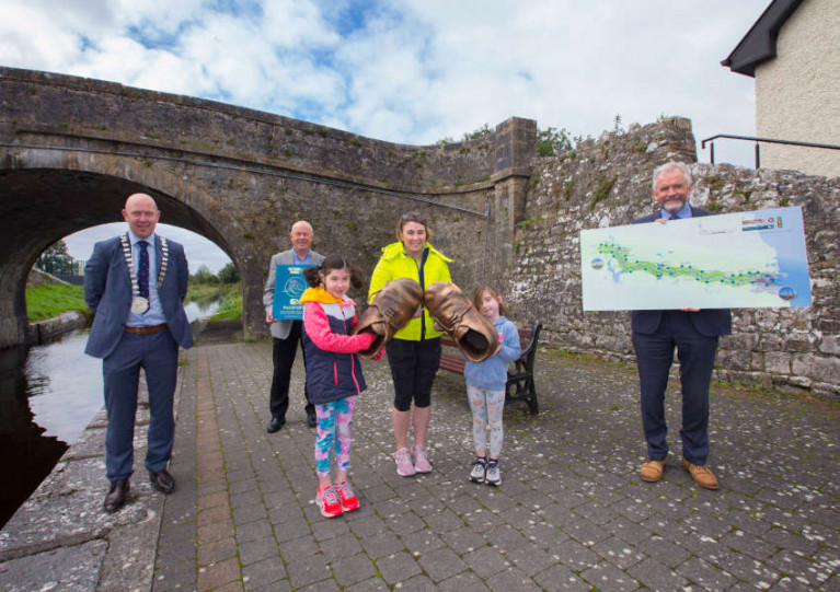
The Loughs Agency recently took its StreamKeepers programme to the Glenelly Valley in Co Tyrone for an event aimed at encouraging people to get involved with their local waterways and environment.
The community outreach programme collaborated with the Glenelly Historical Society for the most recent leg of the initiative and one of the society’s funders, Rose Mary Murphy, was delighted with the event.
“The StreamKeepers event was a fantastic opportunity for members of the public to learn about the heritage value and natural history of the local waterways here in Glenelly,” she said.
 Community members learn about the biodiversity of their local environment during the StreamKeepers event | Credit: Jason McCartan Photography
“Our group started 20 years ago with the aim of maintaining a connection to the past. We set up a ‘Glenelly Our Home’ page on Facebook and shared stories and photographs from the local area. This resulted in posts from people in places as far away as America and Australia who were interested in learning more about the history of Glenelly.
“For the StreamKeepers event, we decided to focus on the bridges that are located near waterways. In Badoney Upper, there are 51 townlands, and in these townlands, bridges were created as an entry point to inaccessible locations.
“Many of these townlands no longer have any inhabitants, but we hope that programmes such as StreamKeepers will continue to educate the community about the importance of maintaining their local waterways, which in turn could revive interest in these areas. Our plan is to simply appreciate history and continue to educate future generations about Glenelly.”
 Some of the members of the local community who took part in the recent StreamKeepers event in Co Tyrone | Credit: Jason McCartan Photography
Aoibheann Gillespie-Mules is the environmental education and outreach Officer at the Loughs Agency, and she believes it is imperative that programmes such as StreamKeepers provide an opportunity for people to look after their local streams, rivers and lakes.
She said: “StreamKeepers brings people of all ages together, not only to preserve our waterways, but to create a valuable learning experience while looking after the environment.
“It offers groups the opportunity to discover, explore and learn about their local watercourse. The programme is facilitated by Loughs Agency staff and involves the exploration of rivers, discovering their journey through time as well as exploring positive connections through the river system.”
See the Loughs Agency website for more information about the StreamKeepers programme.
The Inland Navigations of Ireland Historical Society will hold its annual conference for 2023 on Saturday 25 March at the Inland Waterways Association of Ireland’s (IWAI) Dunrovin building at Coosan Point near Athlone.
Topics on the agenda include post-Covid updates for Ireland’s inland waterways from the IWAI and the Heritage Boat Association; the Waterways Ireland archive; the Barrow Navigation; and managing the archaeology of the Shannon.
Admission is €15 paid at the door (exact change in cash only). Tea/coffee and lunch will be provided — but bring a mug!
This conference is organised by IWAI Offaly in partnership with the IWAI, Heritage Boat Association and Waterways Ireland. The conference agenda is attached below.
Grand Canal: Greenway Partially Closed Until End of February for Continued Works on ‘Four Pots’ Restoration
Waterways Ireland advises users of the Grand Canal Greenway that the greenway section from Digby Bridge to Sallins in Co Kildare will remain closed until the end of February for continued works on restoring the Four Pots overflow structure.
As previously reported on Afloat.ie, the Four Pots is a unique structure located alongside the Grand Canal towpath between the Leinster Aqueduct and Digby Bridge.
Its four circular channels of varying depth helped reduce the water pressure and volume rate before discharge from the canal back to the River Liffey through a series of channels, the cross-border body for Ireland’s inland waterways says.
Grand Canal: Greenway Partially Closed Until End of January for Continued Works on ‘Four Pots’ Restoration
Waterways Ireland advises users of the Grand Canal Greenway that the greenway section from Digby Bridge to Sallins in Co Kildare will remain closed until the end of January 2023 for continued works on restoring the Four Pots overflow structure.
As previously reported on Afloat.ie, the Four Pots is a unique structure located alongside the Grand Canal towpath between the Leinster Aqueduct and Digby Bridge.
Its four circular channels of varying depth helped reduce the water pressure and volume rate before discharge from the canal back to the River Liffey through a series of channels, the cross-border body for Ireland’s inland waterways says.
Grand Canal: Greenway Closure in Co Kildare for Restoration of ‘Four Pots’
Waterways Ireland advises users of the Grand Canal Greenway that the section from Digby Bridge to Sallins in Co Kildare will be closed from Monday 28 November to Tuesday 20 December in order to facilitate the restoration of the Four Pots overflow structure.
The Four Pots is a unique overflow structure located alongside the Grand Canal towpath between the Leinster Aqueduct and Digby Bridge, the cross-border body for Ireland’s inland waterways says.
No longer in use, this ingenious overflow system has four circular channels of varying depth that helped reduce the water pressure and volume rate before discharge from the canal back to the River Liffey through a series of channels.
Explore Dublin Port’s Rich Heritage on Walking Tour This Sunday
Places are still available for this Sunday’s heritage walking tour of Dublin Port with Anthony Finnegan as part of Dublin Port Company’s events for Heritage Week
Dublin Port’s history dates back to 1707 and while the company has always looked forward, the port has never lost sight of its substantial heritage.
Much of the evolution of communities in the North and East Wall areas is inextricably linked either to the port itself, or the numerous industries which developed around it.
Railways, shipbuilding, car assembly, timber importers, and coal are some of the many businesses that flourished and evolved throughout the port’s history.
The early housing stock built in the vicinity of the port was developed to accommodate the workers and from those communities came significant artists, musicians, writers and poets.
Anthony Finnegan, a registered tour guide, served as a shore engineer at Dublin Port for nearly 30 years. Join him on a 45-minute walking tour this Sunday afternoon 14 August which starts at ‘the Sphere’ in Port Centre on Alexandra Road and concludes in Dublin Port’s new graving dock Heritage Zone.
The tour is free, with starting times at noon and 1pm, but booking is essential via the Eventbrite page.
Dublin Port Company advises the following: Parking is available at Dublin Port Centre. Access both on foot and by car via the gates on Alexandra Road. The tour will include the maritime garden which has a small number of steps. Port Centre will be closed so there is no access to toilet facilities on site.
National Famine Way Evokes Story Of Forced Migration In Black ’47
A new interactive outdoor experience along the Royal Canal hopes to bring to life the experience of famine emigrants who walked from Strokestown to Dublin at the height of An Gorta Mór.
The National Famine Way was launched last Thursday 10 September by the National Famine Museum at Strokestown Park with a special National Famine Way Passport/Guide and OSI trail map.
The 14-page guidebook highlights local historical landmarks and allows walkers and cyclists to record their progress with 27 stage stamps along the specially developed 165km heritage route.
The trail details the ill-fated journey of 1,490 famine emigrants who walked from Strokestown Park in Co Roscommon to ships in the capital in 1847, a year which became infamous as ‘Black ’47’.
And the new Passport/Guide is centred around the walk of one of the original famine emigrants from Strokestown Park: 12-year-old Daniel Tighe, who remarkably survived the horrific journey to Quebec, Canada on one of the worst famine ships.
Award-winning author Marita Conlon-McKenna wrote short pieces that reimagine Daniel’s journey in 1847 and are connected to over 30 pairs of bronze children’s shoes dotted along the route. They are also available as audio recordings to listen to at www.nationalfamineway.ie
The National Famine Way crosses six counties — Roscommon, Longford, Westmeath, Meath, Kildare and Fingal — on the way to Dublin, mostly along the Royal Canal, and a completion certificate is awarded at the end of the trail at EPIC: The Irish Emigration Museum at George’s Dock.
The National Famine Museum collaborated on the project with Waterways Ireland and county councils along the route, which is designed to be accessible for families, schools, casual walkers and cyclists — as well as those who want to learn more about the famine and Ireland’s history.
Anne O’Donoghue, chief executive of the Irish Heritage Trust, which cares for Strokestown Park and the National Famine Museum, said: “This heritage trail not only links two significant Irish museums but also makes the connection between Ireland’s Hidden Heartlands and Ireland’s Ancient East.
“In addition to the health, historical, cultural and arts impact, the trail also has the potential to open up rural Ireland and offer an economic boost to local communities with cycling hire, cafés, bars, shops and accommodation all benefiting with an expected economic impact of over €2 million spent along the route.”
Exhibition of Art-Works Sets Sail on HMS Caroline
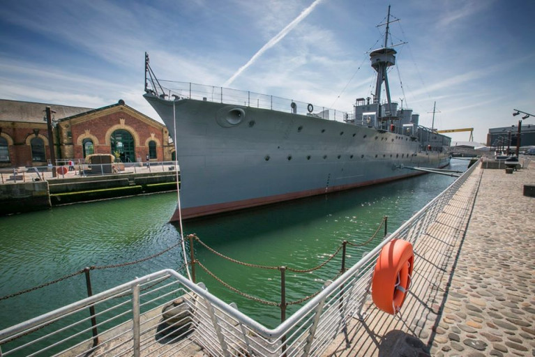
On board HMS Caroline an exhibition of artworks produced by a community group in Belfast forms part of a National Heritage Lottery Fund project.
As the Belfast Telegraph writes, Members of Forthspring Inter-Community Centre have used their artistic talents to produce a series of paintings, sculptures and textiles to produce the Art Trail exhibition, art pieces inspired by the World War One ship which is moored in Belfast Harbour.
Ruth Osborne, learning and community engagement manager at HMS Caroline, said the project shines a light on archival material including photographic collections and sailors' diaries which were saved with the ship.
The pieces themselves have been installed in various locations on board. HMS Caroline has been engaging with communities across Northern Ireland since 2016.
Lough Erne Locals Called To Share Folklore, Histories & Stories For Spiritual Trail Project
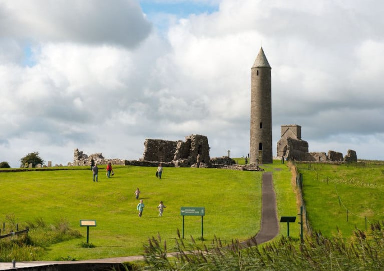
Shared stories of folklore and the history of spiritual sites around Lough Erne will be the subject of a public meeting at Waterways Ireland HQ in Enniskillen later this month.
Hosted by Waterways Ireland in partnership with the Lough Erne Landscape Partnership, the community outreach event encourages locals around the Fermanagh waterway to drop in and share their stories and folk tales, as well as memorabilia and photographs, that only they would have.
Doors will be open from 1pm to 8pm on Monday 27 January, with the Centre for Data Digitisation and Analysis at Queen’s University Belfast on hand to record these oral histories and more for posterity.
The project will also inform the development of the Lough Erne Spiritual Trail, an initiative of Waterways Ireland and the Lough Erne Landscape Partnership.
Eleven significant spiritual and/or ecclesiastical sites have been selected, including Devenish Island, White Island (North), Davy’s Island, Inishmacsaint, Caldragh (Boa Island), Cleenish, St. Ronan’s Aghalurcher, Galloon, Killadeas, Derryvullen and Tievealough.
Intriguing Northern Ireland Maritime Heritages Go on Display
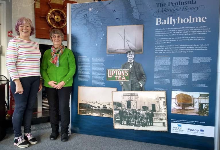
In a unique opportunity to portray the intriguing maritime heritage of the Ards Peninsula and North Down in Northern Ireland, seven communities have produced a maritime history of each of their locations – Portaferry, Portavogie, Ballyhalbert and Cloughey on the Ards Peninsula and Donaghadee, Groomsport and Ballyholme on the North Down coast.
The project is supported by the EU’s PEACE IV Programme, managed by the SEUPB (Special EU Programmes Body). This is an initiative of the European Union which has been designed to support peace and reconciliation in Northern Ireland and the Border Region of Ireland. It provides support to projects that contribute towards the promotion of greater levels of peace and reconciliation. The Programme also places a strong emphasis on promoting cross-community relations and understanding in order to create a more cohesive society.
Ards and North Down Borough Council was awarded £3.3M from the European Union’s PEACE IV Programme to deliver the PEACE IV Action Plan and a total of 19 projects are being rolled out across the Borough.
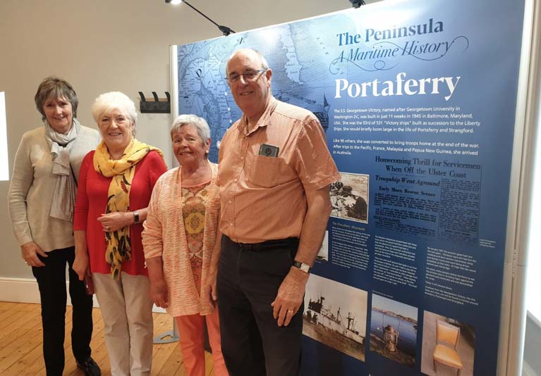 The Portaferry panel
One of these projects involves a programme which engages communities across the Borough to explore jointly their shared maritime history and develop connections linked to what each community has in common thus creating more cohesive communities. The project will improve cross-community cohesion between groups, particularly in rural towns and villages by jointly exploring their shared history and heritage.
Each of the seven communities has produced a large display panel telling stories, illustrated with photographs, of important people, shipwrecks, businesses, tales of bravery and memorable history particular to each location. The aim is to make available this information in the form of a travelling exhibition, online material, touch screen access and eventually an App telling the same stories. The panels are the property of each community to be also used as they think fit.
Pulling this together is Copius Consulting, a Belfast based company who have facilitated the programme implementation as a delivery agent commissioned by Ards and North Down Borough Council Peace IV Programme.
Match-funding has been provided by the Executive Office in Northern Ireland and the Department of Rural and Community Development in Ireland.


 as lead helm, rounds the Fastnet Rock on the way to the overall win in 1987")


 Michael Murphy Schull Harbour Sailing Club (SHSC), Eric Coogan Heineken Ireland, Mark Murphy, Commodore SHSC, Jack Allen SHSC, Carmel O'Regan SHSC, Cornelious Ndlovu, Schull Harbour Hotel Operations Manager and Derval Murphy SHSC")
