


Displaying items by tag: Marine Notice
Irish Coast Guard Confirms Recent Changes to VHF Working Channels
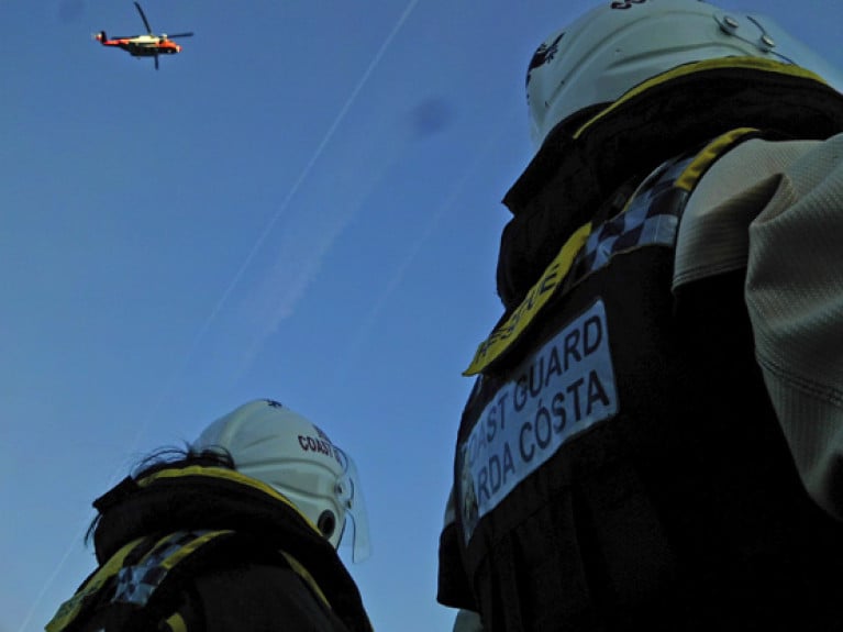
The Irish Coast Guard has has upgraded radio equipment at a number of VHF network remote locatosn in recent months.
Following these upgrades, the table below sets out the detail of the new coastguard working channels that are now in operation:
|
Site |
Radio Call Sign |
Current Channel |
New Channel |
|
Howth Hts |
Dublin Coast Guard |
CH 83 |
CH 03 |
|
Rosslare Hts |
Rosslare Coast Guard |
CH 23 |
CH 05 |
|
Mine Hd Hts |
Mine Head Coast Guard |
CH 83 |
CH 03 |
|
Cork Hts |
Cork Coast Guard |
CH 26 |
CH 02 |
|
Bantry Hts |
Bantry Coast Guard |
CH 23 |
CH 05 |
|
Valentia Hts |
Valentia Coast Guard |
CH 24 |
CH 62 |
|
Shannon Hts |
Shannon Coast Guard |
CH 28 |
CH 64 |
|
Belmullet Hts |
Belmullet Coast Guard |
CH 83 |
CH 63 |
|
Clifden Hts |
Clifden Coast Guard |
CH 26 |
CH 03 |
|
Malin Hd Hts |
Malin Head Coast Guard |
CH 23 |
CH 05 |
|
Scalp Mountain |
Malin Head Coast Guard |
CH 85 |
CH 01 |
|
Glen Hd Hts |
Glen Head Coast Guard |
CH 24 |
CH 03 |
The remaining sites of Carlingford (CH04), Wicklow (CH02), Mizen Head (CH04), Galway (CH04), Clew Bay (CH05), Donegal Bay (CH02), Lough Ree (CH62) and Lough Derg (CH61) will retain their respective currently assigned channel.
A map showing the radio sites including the new channels and a guide to transmissing VHF distress alerts are included in Marine Notice No 61 of 2020, which is available to download below
Subsea Exploration Works Off North West Coast Start This Week
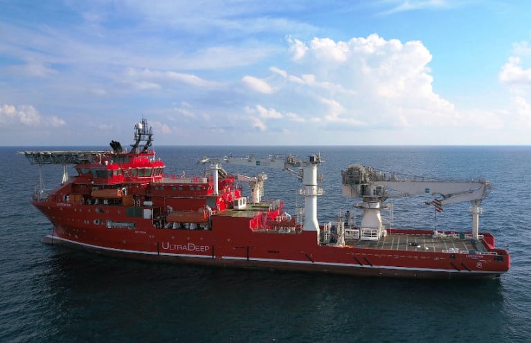
Ultra Deep Solutions will be carrying out subsea exploration activities off the North West Coast from tomorrow, Wednesday 16 December.
The work will be conducted a number of weeks, progress and weather depending, within the vicinity of 55° 19’N, 009° 41’W.
Vessel-mounted equipment, ROV and saturation divers will be operating from the MV Lichtenstein (Callsign C6DC6), which requests a wide berth from all other vessel due to its restricted ability to manoeuvre.
Further details are included in Marine Notice No 60 of 2020, which is available to download below.
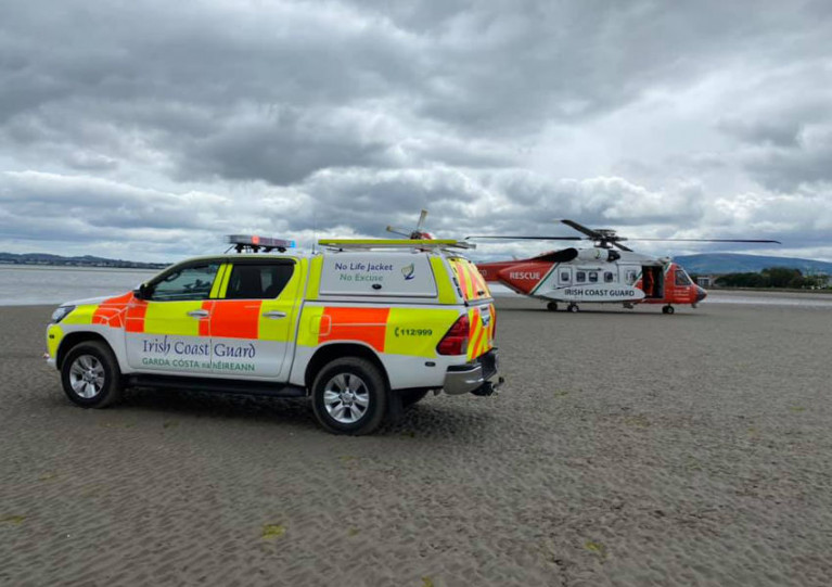
Drowning Incidents Prompt Marine Notice Highlighting Dangers of Boating Single-Handed & Without Lifejacket
The latest Marine Notice from the Department of Transport draws attention to the Code of Practice for the Safe Operation of Recreational Craft, following two recent reports from the Marine Casualty Investigation Board (MCIB).
In October, the MCIB’s report into the death of a long West Cork fisherman 12 months previously suggested that he may have fallen overboard from this open-deck vessel.
As previously reported on Afloat.ie, the MCIB determined that 23-year-old Kodie Healy was not wearing a lifejacket or personal flotation device (PFD) prior to the indecent in Dunmanus Bay on 9 October 2019 — and he may not have been aware of a personal locator beacon on his vessel.
September’s report into an incident on Lough Mask in March 2019 also found that the individual involved was not wearing a lifejacket.
The MCIB was unable to establish the cause of the incident on 8 March in which the 78-year-old experienced angler drowned. But the fact his boat was found upright suggests he had fallen overboard and was unable to get back into his boat.
Marine Notice No 58 of 2020 (available to download below) highlights to all operators of recreational craft the important of abiding by legal requirements to wear a PFD while on board an open craft (or on the deck of decked craft) under seven meres in length.
As well as reminding boaters to ensure they check current weather forecasts and sea/lake/river conditions prior to departure, the notice also underscores the increased risks involved in single-handed boating.
Boaters should carry out a risk assessment to minimise the inherent risks involved when setting out single-handed without any colleagues to help or raise the alarm when in difficulty.
The Code of Practice is a free download from the Department of Transport website. Hard copies are also available on request, in both English and Irish, from the Marine Safety Policy Division at [email protected]
Techworks Marine Schedules Wave Buoy Deployment Off Wicklow
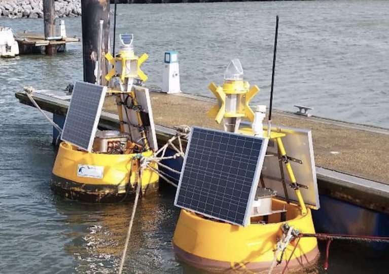
TechWorks Marine has scheduled the deployment of a wave buoy off the coast of Wicklow on Tuesday 8 December, weather allowing.
The buoy will be a yellow DB 500 and have a flashing light sequence of five flashes every 20 seconds, with a range of three nautical miles. The buoy will be marked with a St Andrew’s sross and radar reflector.
The wave buoy will be deployed at 53° 2' 35” N, -5° 41' 17” W by the the AMS Retriever (Callsign MEHI8) with an AIS system on board which has a provisional callsign of CWPW01.
If the deployment is delayed due to the weather, it will be carried out on the next viable tide and weather window. Once deployed, the wave buoy will remain on site for a minimum of six months.
Further details can be found in Marine Notice No 57 of 2020, a PDF of which is available to download below.
Gas Field Decommissioning Works off West Cork This Week
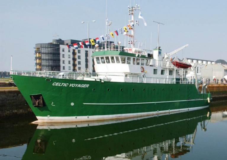
Seabed survey operations in the Kinsale, Greensands, Ballycotton and Seven Heads gas fields off West Cork are set to commence from tomorrow, Sunday 6 December.
PSE Kinsale Energy will undertake the decommissioning works on and around the relevant subsea infrastructure over the next week, weather permitting, from the RV Celtic Voyager (Callsign EIQN).
The surveys will extend over an area of 2.5km radius (including the area required by the vessel to turn) from each well head, towing a submerged cable of up to 500m behind the vessel.
Full coordinates for these survey operations and a map of the area are included in Marine Notice No 56 of 2020, a PDF of which can be downloaded below.
Waverider Buoy Deployment in Brandon Bay

Mariners in Brandon Bay in Co Kerry are advised of the Marine Institute’s deployment of a Waverider buoy over the coming days, subject to weather conditions.
The Waverider is a yellow spherical buoy, 1m in diameter ad equipped with an antenna and light at a height of approximately 2m. The light will flash yellow for five seconds every 20 seconds in hours of darkness.
The buoy is being deployed for 12 months in the centre of Brandon Bay (52 16.94 N, 010 05.69 W) by the Ocean Supporter (Callsign EITS6), which will display appropriate signals and lights.
More details can be found in Marine Notice No 55 of 2020, a PDF of which is available to download below.
Subsea Cable Survey Operations Off South-East Coast
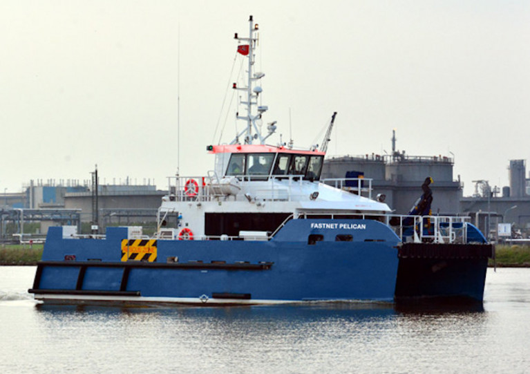
Mariners off the South-East Coast of Ireland are advised of subsea cable survey operations currently under way, subject to weather conditions.
The survey was scheduled to begin this past Thursday 26 November and continue for at least eight days and up to two weeks.
It follows a route south-west from the 2m contour at Ballyteige Bay before veering south to the 12-nautical-mile limit.
The DNV-classed wind farm service and survey support vessel Fastnet Pelican (Callsign 2FNX7) is conducting this survey using a multibeam echo sounder and sub bottom profiler as well as a towed array with a sidescan sonar and magnetometer.
The vessel will have active AIS and will display all relevant lights and shapes.
Due to restricted manoeuvrability, other vessels are asked to maintain a distance of at least one nautical mile from the Fastnet Pelican.
Full details of this survey, including all relevant coordinates, are included in Marine Notice No 54 of 2020, a PDF of which can be downloaded below.
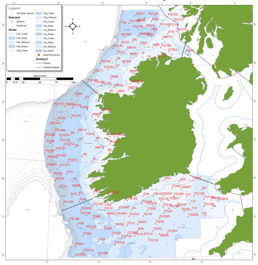
2020’s Irish Groundfish Survey Gets Under Way
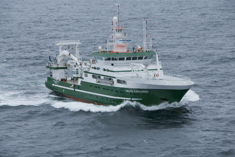
This year’s Irish Groundfish Survey (IGFS 2020) of the North, West and South Coasts of Ireland is set to commence today, Sunday 25 October.
Carried out by the Marine Institute, the IGFS is a demersal trawl survey consisting of around 170 fishing hauls, each of of 30 minutes’ duration, in ICES areas VIa, VIIb, VIIg and VIIj.
As part of the requirements for the 2020 survey, fishing will take place within a two-nautical-mile radius of indicated positions.
The survey will be conducted by the RV Celtic Explorer (callsign EIGB) which will display appropriate lights and signals.
The vessel will be towing a high headline GOV 36/47 demersal trawl during fishing operations.
Co-ordinates and approximate locations of these hauls are included in Marine Notice No 48 of 2020, a PDF of which is available to download below.
The Marine Institute requests that commercial fishing and other marine operators keep a 2nm area around the tow mid-points clear of any gear or apparatus during the survey period between now and October and Thursday 10 December.
This survey follows the annual Irish Anglerfish and Megrim Survey which was conducted off the West, South West and South Coasts this past February and March.
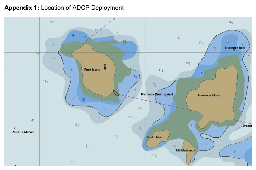
Marine Notice: ADCP Deployment Off Inis Mór For Highwave Project
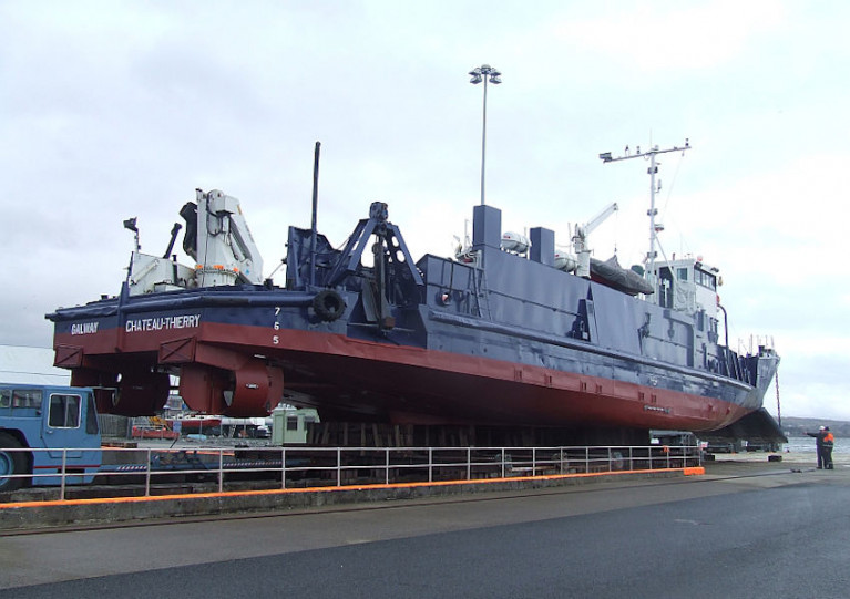
University College Dublin have been set to deploy an Acoustic Doppler Current Profiler (ADCP) off Inis Mór in the Aran Islands between today, Thursday 15 October, and next Wednesday 21 October as part of the Highwave project.
The university previously deployed an ADCP in February as par of the same ocean wave data modelling project.
Thos latest deployment, from the MV Chateau-Thierry (callsign EIHK6), will be some 0.6 nautical miles from Rock Island lighthouse — at 53°08’57.4” N, 009°52’23.4” W. The vessel will display appropriate lights and signals.
Navigational warnings will be issued by radio when the deployment of the marker buoys takes place. These buoys will be yellow spherical markers, 40cm in diameter and flashing yellow every five seconds.
Irish Coast Guard Issues Reminder On Planned Changes To VHF Channels
The Irish Coast Guard is reminding mariners of its planned changes to the VHF working channels currently used for communications with the public.
As previously reported on Afloat.ie, upgrades of radio equipment at a number of remote locations around the coast will be made over a 10-week period scheduled to begin tomorrow, Tuesday 6 October.
Notwithstanding the changes, which are also outlined in the previous report, Channel 16 will remain available at each site for distress, safety and calling.
Channel 67 is also available when required but may not be actively monitored at all times.
Updates as the work progresses will be made on the coastguard’s social media accounts in Twitter, Facebook and Instagram as well as on the gov.ie and Safety on the Water websites.


 coming through Blasket Sound in the Sigma 38 Gambit")


 are one of four Irish pairings selected to compete at the 2024 International 420 Open European Championships in July")


 as lead helm, rounds the Fastnet Rock on the way to the overall win in 1987")


