Menu

Ireland's sailing, boating & maritime magazine

Inland afloat headers


Displaying items by tag: Marine Notice

#MarineNotice - Maynooth University will carry out a geophysical research survey off the North West Coast of Ireland from next weekend. 

Work is expected to commence on Sunday 6 May and last for approximately nine days, subject to weather conditions.

The Marine Institute’s research vessel RV Celtic Voyager (Callsign EIQN) is scheduled to carry out the works for the Mara survey, undertaken by researchers in Maynooth University to collect geophysical acoustic survey data as well as sediment grab and core samples.

The survey will use relatively low amplitude sound sources to image into the seabed including an echosounder and a sparker system, which will allow for the characterisation of seabed type to inform the deglacial dynamics of the climatically driven British Irish Ice Sheet.

The vessel will, on occasion, be towing a hydrophone cable and other equipment, up to a maximum of 50 metres behind the vessel. The vessel will be restricted in its movements when towing a cable astern.

All other vessels are requested to give the operation a wide berth. The vessel will be listening on VHF Channel 16 throughout the project.

Details of the survey area, relevant co-ordinates and contact information are included in Marine Notice  No 19 of 2018, a PDF of which is available to read or download HERE.

Published in Marine Science

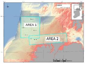
#MarineNotice - Hydrographic and geophysical surveys will be undertaken in the Celtic Sea and Atlantic Ocean under the INFOMAR (Integrated Mapping for the Sustainable Development of Ireland’s Marine Resources) programme until October 2018.

Geological Survey Ireland vessels the RV Keary (Callsign EI-GO-9), RV Geo (Callsign EI-DK-6), RV Tonn (Callsign EI-PT-7), RV Mallet (Callsign EI-SN-9) and RV Lir (Callsign EI-HI-2) are already involved in scheduled surveys since March.

Marine Institute vessels the RV Celtic Explorer (Callsign EIGB) and RV Celtic Voyager (Callsign EIQN) will begin surveys this weekend, starting with the former vessel on a three-week survey from Sunday 22 April.

The Celtic Voyager and the Celtic Explorer will be towing a magnetometer sensor with a single cable of up to 200 metres in length. The vessels will display appropriate lights and markers, and will be listening on VHF Channel 16 throughout the course of the surveys.

Details of co-ordinates for these surveys are included in Marine Notice  No 18 of 2018, a PDF of which is available to read or download HERE.

Note that the Atlantic Ocean Area may not be surveyed in 2018, but if for operational reasons the survey does take place, it will be during the dates set out above for the Celtic Voyager surveys listed therein. In that event, the Marine Notice will be updated with specific dates.

Published in Marine Science

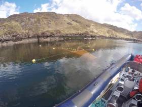
#MarineNotice - Inland Fisheries Ireland (IFI) will be carrying out scientific sampling using bag nets and sentinel cages in Killary Harbour and surrounding waters. 

Similar to last year’s operation, the bag nets will start at the shore and extend into the water approximately 25 meters. The sentinel cages (nets) will be anchored near shore and will not interfere with navigable waters. 

All nets will be clearly marked with brightly coloured buoys with IFI identification so that any unintentional retrieval can be notified.

Deployment operations, which were set to begin on Thursday 12 April, are being carried out using the RIB Sea Breeze (Callsign EI-5724) and are subject to weather conditions. The nets will be checked daily, also weather dependent, and all sampling nets and buoys will be retrieved on Friday 8 June.

Full details of co-ordinates and contact information are included in Marine Notice  No 17 of 2018, a PDF of which is available to read or download HERE.

Published in Coastal Notes

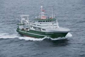
#MarineNotice - The Marine Institute’s annual Irish Anglerfish and Megrim Survey (IAMS) for 2018 is scheduled to resume today, Tuesday 10 April.

After January's survey off the West and South Coasts, this month's survey will be carried out till Saturday 21 April off the North and North West Coasts of Ireland in fulfilment of Ireland’s Common Fisheries Policy obligations.

The IAMS is a demersal trawl survey consisting of approximately 50 otter trawls of 60 minutes duration in ICES area 6a. Fishing will take place within a three nautical mile radius of the positions indicated in Marine Notice No 15 of 2018, a PDF of which is available to read or download HERE.

Survey operations will be conducted by the RV Celtic Explorer (Callsign EIGB), which will display all appropriate lights and signals during the survey and will also be listening on VHF Channel 16.

The vessel will be towing a Jackson demersal trawl during fishing operations. The Marine Institute requests that commercial fishing and other marine operators keep a three nautical mile area around the tow points clear of any gear or apparatus during the survey period outlined above.

Specifics of any fishing gear or other obstructions that are known and cannot be kept clear of these survey haul locations can be notified using the contact details provided in the Marine Notice.

Published in Fishing

#MarineNotice - Marine Notice No 14 of 2018 advises that as part of the Donegal Group B Sewerage Scheme, remedial works are being carried out this week by Norfolk Marine at the Bundoran outfall in Donegal Bay.

These works were scheduled to begin on Tuesday 3 April to last for around one week at 54° 28.778’ N and 08° 19.304’ W, conducted from the vessel Chateau Thierry (Callsign EI-HK-6). An additional small boat or RIB will also be involved in the operation as required.

The work vessel will display appropriate lights and markers, and will monitor VHF Channel 16 throughout the project.

Published in Coastal Notes

#MarineNotice - Marine Notice No 13 of 2018 advises that the No 3 Green Perch at the entrance to Castletownbere  Fishery Harbour Centre in West Cork has been removed due to damage.

The No 3 Green Perch has been replaced by a 1.5m green buoy in position 51° 38’ 49.387” North, 09° 54’ 27.41” West.

The light characteristic is a green flash every five seconds. This buoy will remain in position until further notice.

For safety reasons, mariners are requested to proceed slowly and with caution when in the vicinity of the green buoy.

For further information, contact the Castletownbere Harbourmaster’s Office at +353 27 70220.

Published in Irish Harbours

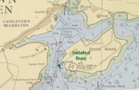
Marine Notice No 12 of 2018 advises that the Marine Institute was scheduled to deploy a bottom-mounted acoustic Doppler current profiler (ADCP) on the Aran prawn ground today, Monday 26 March.

The ADCP will be recovered in May and will remain in place for the duration. The purpose of this deployment is to measure water current speed over a depth range using the Doppler effect of sound waves scattered from particles within the water column.

The ADCP was set to be deployed at Latitude 53°46.133 N and Longitude 9°47.4 W by the RV Celtic Voyager (Callsign EIQN) listening on VHF Channel 16.

As this is sensitive scientific equipment, it is requested that fishermen and marine operators engaged in such activities as bottom trawling or laying of static gear avoid the location concerned to avoid damaging the equipment or damaging fishing gear.

Published in Marine Science

The Irish Maritime Administration at the Department of Transport, Tourism and Sport has issued a Marine Notice to remind the public of the law in relation to being under the influence of alcohol and / or drugs when operating or while on board a recreational craft or any vessel in Irish waters, or on board vessels or objects being towed by recreational craft.

The recently published Annual Report of the Marine Casualty Investigation Board (MCIB) highlights the fact that alcohol or drug consumption continues to be a factor in marine incidents, including incidents involving recreational craft. Successive MCIB Annual Reports have shown that incidents are occurring where diminished human performance and impairment due to the effects of alcohol and / or drug consumption have been primary causes or contributing factors, leading to the loss of life in some cases. In the recent Annual Report, the MCIB Board reminds all vessel operators of the need to take personal responsibility and to ensure that they are fit to undertake their planned voyage.

The Department of Transport, Tourism and Sport wishes to remind all recreational craft users that it is the responsibility of each individual taking to the water to be mindful of their own safety:

• YOU must take personal responsibility for your actions on the water.

• YOU must avoid alcohol and drugs before or during a voyage.

• If you fail to operate safely and to comply with the law in relation to alcohol and drug consumption YOU put your life and your vessel at risk as well as the lives of others, including members of the rescue services.

• It is against the law to consume alcohol and drugs in circumstances that could affect the safety of others on board or others using Irish waters, or create a disturbance on board or be a nuisance to others using Irish waters.

• Alcohol speeds up the rate of body cooling and thus increases the risk of hypothermia in the event that you fall into the water.

Regulations 8 and 9 of the Pleasure Craft (Personal Flotation Devices and Operation) (Safety) Regulations 2005 [S.I. No. 921 of 2005], as amended, set out the law regarding the consumption of alcohol or drugs while on board a pleasure craft, including prohibitions on operating a pleasure craft while under the influence. Failure to comply with the law can result in a fixed payment of €150 and/or prosecution proceedings which, on summary conviction, can lead to a fine of up to €5,000. A pleasure craft includes personal watercraft, such as jet skis, and fast power craft.

Sections 28 to 30 of the Maritime Safety Act 2005 (No. 11 of 2005) contain a range of provisions relating to the prohibition on operating or being on board a vessel in Irish waters while under the influence of alcohol or drugs, and the associated penalties. These include the following prohibitions:

1. A person in command or in charge or another member of the crew of a vessel in Irish waters (or an Irish ship in waters anywhere) must not operate or control or attempt to operate or control the vessel or carry out any task or duty in relation to the operation or control of the vessel while he or she is under the influence of alcohol or a drug or any combination of drugs, or drugs and alcohol to such an extent as to be incapable of properly controlling or operating the vessel or carrying out the task or duty (section 28).

2. A person on board a vessel in Irish waters (or an Irish ship in waters anywhere) must not consume alcohol or take a drug or any combination of drugs or drugs and alcohol while on board the vessel in circumstances which could affect the safety of persons or create a disturbance or serious nuisance on board the vessel or affect the safety of other persons using Irish waters or constitute a nuisance to such persons (section 30).

3. Failure to comply with the above requirements is an offence and the person is liable on summary conviction to a fine not exceeding €5,000 or to imprisonment for a term not exceeding 3 months or both.

4. If a person in command or in charge or another member of the crew of a vessel is, while on duty, under the influence of alcohol or a drug or any combination of drugs or drugs and alcohol to such an extent that his or her ability to discharge his or her duties is impaired, he or she commits an offence and is liable on summary conviction to a fine not exceeding €5,000 (section 29).

5. A person on board a vessel in Irish waters (or on an Irish ship in waters anywhere) who through any deliberate or reckless action or by reason of being under the influence of alcohol or a drug or any combination of drugs or drugs and alcohol puts at risk or endangers the safety, security or seaworthiness of the vessel or the lives or safety of persons on board commits an offence and is liable on summary conviction to a fine not exceeding €5,000 or to imprisonment for a term not exceeding 6 months or both, or on conviction on indictment, to a fine not exceeding €100,000 or to imprisonment for a term not exceeding 2 years or both (section 32). 

Irish Maritime Administration
Department of Transport, Tourism and Sport
Leeson Lane, Dublin 2, D02 TR60, Ireland.
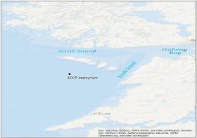
Published in Marine Warning

#MarineNotice - Fugro is currently carrying out marine operations for the HAVFRUE Subsea Cable System Project, further to its work carried out in January.

The current survey within Irish territorial waters off the North West Coast began on Wednesday 14 March and is expected to run till midweek next week.

The MV Fugro Discovery (Callsign 3EKE6) is surveying on Segment 2 within Irish EEZ waters towards the 1,500m contour line at the shelf, followed by operations at the BU1 position and Segment 3 as indicated on the charts included with Marine Notice  No 10 of 2018, a PDF of which is available to read or download HERE.

Published in News Update

#Ports&Shipping - The Department of Transport, Tourism and Sport (DTTAS) has issued an advisory to the maritime sector to make cybersecurity an integral part of their risk assessment exercises and continuity plans.

At the Maritime Safety Committee (MSC) of the International Maritime Organization (IMO) in 2017, measures were agreed in relation to the cyber risk being taken into account by shipping companies in respect of the International Safety Management Code.

Resolution MSC 428(98) calls for cyber risks to be appropriately addressed in safety management systems no later than the first annual verification of the company's Document of Compliance after 1 January 2021.

The IMO has also published guidelines on cybersecurity for the industry, included in Marine Notice No 08 of 2018, a PDF of which is available to read or download HERE.

In relation to ports, the approach that the DTTAS is planning to take in Ireland is to incorporate a cybersecurity risk element in the security assessments which are carried out in accordance with Regulation (EC) No 725/2004 1 and Directive 2005/65/EC 2 in our ports and port facilities.

The next five-yearly renewal of these assessments is due in all Irish ports by 30 June 2019.

Published in Ports & Shipping
Page 31 of 54

General Information on using Waterways Ireland inland navigations

Safety on the Water

All users of the navigations are strongly recommended to make themselves aware of safety on the water for whatever activity they are involved in and to read the advice offered by the various governing bodies and by:

The Dept. of Transport, Ireland: www.gov.ie/transport and The Maritime and Coastguard Agency, UK, The RNLI – Water Safety Ireland for information in terms of drowning prevention and water safety.

Registration of Vessels

All vessels using the Shannon Navigation, which includes the Shannon-Erne Waterways and the Erne System must be registered with Waterways Ireland. Only open undecked boats with an engine of 15 horsepower or less on the Shannon Navigation, and vessels of 10 horsepower or less on the Erne System, are exempt. Registration is free of charge.

Craft registration should be completed online at: https://www.waterwaysireland.org/online-services/craft-registration

Permits for use of the Grand and Royal Canals and the Barrow Navigation

All vessels using the Grand and Royal Canals and the Barrow Navigation must display appropriate valid Permit(s) i.e A Combined Mooring and Passage Permit (€126) and if not intending to move every five days, an Extended Mooring Permit (€152).

Permit applications should be completed online at: https://www.waterwaysireland.org/online-services/canal-permits

Passage on the Royal and Grand Canals – Dublin Area

For boat passage through the locks east of Lock 12 into / out of Dublin on either the Royal or Grand Canals, Masters are requested to contact the Waterways Ireland Eastern Regional Office (M-F 9.30am-4.30pm) on tel: +353(0)1 868 0148 or email [email protected] prior to making passage in order to plan the necessary lock-keeping assistance arrangements.

On the Grand Canal a minimum of two days notice prior to the planned passage should be given, masters should note that with the exception of pre-arranged events, a maximum of 2 boats per day will be taken through the locks, travelling either east or west.

Movements in or out of the city will be organised by prior arrangement to take place as a single movement in one day. Boaters will be facilitated to travel the system if their passage is considered to be safe by Waterways Ireland and they have the valid permit(s) for mooring and passage.

Newcomen Lifting Bridge

On the Royal Canal two weeks’ notice of bridge passage (Newcomen Lifting Bridge) is required for the pre-set lift date, and lock assistance will then also be arranged. A minimum of 2 boats is required for a bridge lift to go ahead.

Waterways Ireland Eastern Regional Office (Tel: +353(0)1 868 0148 or [email protected] ) is the point of contact for the bridge lift.

A maximum number of boats passing will be implemented to keep to the times given above for the planned lifts (16 for the Sat / Sun lifts & 8 for the weekday lifts). Priority will be given on a first come first served basis.

On day of lift, boaters and passengers must follow guidance from Waterways Ireland staff about sequence of passage under bridge & through Lock 1, and must remain within signed and designated areas.

Events Held on the Waterways

All organised events taking place on the waterways must have the prior approval of Waterways Ireland. This is a twelve week process and application forms must be accompanied with the appropriate insurance, signed indemnity and risk assessment. The application should be completed on the Waterways Ireland events page at :

https://www.waterwaysireland.org/online-services/event-approval

Time Limits on Mooring in Public Harbours

On the Shannon Navigation and the Shannon-Erne Waterway craft may berth in public harbours for five consecutive days or a total of seven days in any one month.

On the Erne System, revised Bye Laws state that: No master or owner shall permit a vessel, boat or any floating or sunken object to remain moored at or in the vicinity of any public mooring, including mooring at any other public mooring within 3 kilometres of that location, for more than 3 consecutive days and shall not moor at that same mooring or any other public mooring within 3 kilometres of that location within the following 3 consecutive days without prior permission by an authorised official.

Winter Mooring on the Shannon Navigation and Shannon Erne Waterway

Winter mooring may be availed of by owners during the period 1 Nov to 31 Mar by prior arrangement and payment of a charge of €63.50 per craft. Craft not availing of Winter Mooring must continue to comply with the “5 Day Rule”. Winter Mooring applications should be completed online at : https://www.waterwaysireland.org/online-services/winter-moorings-booking

Owners should be aware that electricity supply and water supply to public moorings is disconnected for the winter months. This is to protect against frost damage, to reduce running costs and to minimise maintenance requirements during the winter months.

Vessel owners are advised that advance purchasing of electricity on the power bollards leading up to the disconnection date should be minimal. Electricity credit existing on the bollards will not be recoverable after the winter decommissioning date. Both services will be reinstated prior to the commencement of the next boating season.

Smart Cards

Waterways Ireland smart cards are used to operate locks on the Shannon Erne Waterway, to access the service blocks, to use the pump-outs along the navigations, to avail of electrical power at Waterways Ireland jetties.

Berthing in Public Harbours

Masters are reminded of the following:

  • Equip their vessel with mooring lines of appropriate length and strength and only secure their craft to mooring bollards and cleats provided for this purpose.
  • Ensure the available berth is suitable to the length of your vessel, do not overhang the mooring especially on finger moorings on floating pontoon moorings.
  • Ensure mooring lines, electric cables and fresh water hoses do not create a trip hazard on public jetties for others users.
  • Carry sufficient fenders to prevent damage to your own vessel, other vessels and WI property.
  • Allow sufficient space between your vessel and the vessel ahead /astern (c.1m) for fire safety purposes and /or to recover somebody from the water.
  • Do not berth more than two vessels side by side and ensure there is safe access/egress at all times between vessels and onto the harbour itself.
  • Do not berth in such a way to prevent use of harbour safety ladders, slipways or pump-outs.
  • Do not allow the bow of your vessel to overhang the walkway of a floating mooring thus creating a hazard for others with an overhanging anchor or bow fendering.
  • Animals are not allowed to be loose or stray at any time.
  • Harbour and jetty infrastructure such as railings, power pedestals, fresh water taps, electric light poles, safety bollards, ladders etc are not designed for the purpose of mooring craft , they will not bear the strain of a vessel and will be damaged.
  • At Carrybridge on the Erne System, Masters of vessels are not permitted to use stern on mooring. Masters of vessels must use the mooring fingers for mooring of vessels and for embarkation / disembarkation from vessels.

Passenger Vessel Berths

Masters of vessels should not berth on passenger vessel berths where it is indicated that an arrival is imminent. Passenger vessels plying the navigations generally only occupy the berths to embark and disembark passengers and rarely remain on the berths for extended periods or overnight.

Lock Lead-in Jetties

Lead-in jetties adjacent to the upstream and downstream gates at lock chambers are solely for the purpose of craft waiting to use the lock and should not be used for long term berthing.

Vessel Wake

Vessel wake, that is, the wave generated by the passage of the boat through the water, can sometimes be large, powerful and destructive depending on the hull shape and engine power of the vessel. This wake can be detrimental to other users of the navigation when it strikes their craft or inundates the shoreline or riverbank. Masters are requested to frequently look behind and check the effect of their wake / wash particularly when passing moored vessels, on entering harbours and approaching jetties and to be aware of people pursuing other activities such as fishing on the riverbank.

Speed Restriction

A vessel or boat shall not be navigated on the Shannon Navigation at a speed in excess of 5 kph when within 200 metres of a bridge, quay, jetty or wharf, when in a harbour or canal or when passing within 100 metres of a moored vessel or boat.

Vessels navigating the Shannon-Erne Waterway should observe the general 5 kph speed limit which applies along the waterway. This is necessary in order to prevent damage to the banks caused by excessive wash from vessels.

Vessels navigating the Erne System should observe the statutory 5kt / 6mph / 10kph speed limit areas.

A craft on the Royal and Grand canals shall not be navigated at a speed in excess of 6km per hour.

A craft on the Barrow Navigation shall not be navigated at a speed in excess of 11km per hour except as necessary for safe navigation in conditions of fast flow.

Bank Erosion

Narrow sections of all the navigations are particularly prone to bank erosion due to the large wash generated by some craft. Masters are requested to be vigilant and to slow down to a speed sufficient to maintain steerage when they observe the wash of their craft inundating the river banks.

Unusual Waterborne Activity

Unusual waterborne vessels may be encountered from time to time, such as, hovercraft or amphibious aircraft / seaplanes. Masters of such craft are reminded to apply the normal “Rule of the Road” when they meet conventional craft on the water and to allow extra room to manoeuvre in the interest of safety.

Sailing Activity

Mariners will encounter large numbers of sailing dinghies from late June to August in the vicinity of Lough Derg, Lough Ree and Lower Lough Erne. Sailing courses are marked by yellow buoys to suit weather conditions on the day. Vessels should proceed at slow speed and with due caution and observe the rules of navigation when passing these fleets, as many of the participants are junior sailors under training.

Rowing

Mariners should expect to meet canoes and vessels under oars on any part of the navigations, but more so in the vicinity of Athlone, Carrick-on-Shannon, Coleraine, Enniskillen and Limerick. Masters are reminded to proceed at slow speed and especially to reduce their wash to a minimum when passing these craft as they can be easily upset and swamped due to their very low freeboard and always be prepared to give way in any given traffic situation.

Canoeing

Canoeing is an adventure sport and participants are strongly recommended to seek the advice of the sport’s governing bodies i.e Canoeing Ireland and the Canoe Association of Northern Ireland, before venturing onto the navigations.

Persons in charge of canoes are reminded of the inherent danger to these craft associated with operating close to weirs, sluice gates, locks and other infrastructure particularly when rivers are in flood and large volumes of water are moving through the navigations due to general flood conditions or very heavy localised precipitation e.g. turbulent and broken water, stopper waves. Shooting weirs is prohibited without prior permission of Waterways Ireland.

Canoeists should check with lockkeepers prior entering a lock to ensure passage is done in a safe manner. Portage is required at all unmanned locks.

Canoe Trail Network – "Blueways"

Masters of powered craft are reminded that a canoe trail network is being developed across all navigations and to expect more organised canoeing along these trails necessitating slow speed and minimum wash when encountering canoeists, rowing boats etc

Rockingham and Drummans Island Canals – Lough Key

It is expected that work on Rockingham and Drummans Island Canals on Lough Key will be completed in 2021. Access to these canals will be for non-powered craft only, eg canoes, kayaks, rowing boats.

Fast Powerboats and Personal Watercraft (Jet Skis)

Masters of Fast Powerboats (speed greater than 17kts) and Personal Watercraft (i.e.Jet Skis) are reminded of the inherent dangers associated with high speed on the water and especially in the confines of small bays and narrow sections of the navigations. Keeping a proper look-out, making early alterations to course and /or reducing speed will avoid conflict with slower vessels using the navigation. Personal Watercraft are not permitted to be used on the canals.

Towing Waterskiers, Wakeboarders, Doughnuts etc

Masters of vessels engaged in any of these activities are reminded of the manoeuvring constraints imposed upon their vessel by the tow and of the added responsibilities that they have to the person(s) being towed. These activities should be conducted in areas which are clear of conflicting traffic. It is highly recommended that a person additional to the master be carried to act as a “look-out” to keep the tow under observation at all times.

Prohibition on Swimming

Swimming in the navigable channel, particularly at bridges, is dangerous and is prohibited due to the risk of being run over by a vessel underway in the navigation.

Age Restrictions on operating of powered craft

In the Republic of Ireland, Statutory Instrument 921 of 2005 provides the legal requirements regarding the minimum age for operating of powered craft. The Statutory Instrument contains the following requirements:

- The master or owner of a personal watercraft or a fast power craft shall take all reasonable steps to ensure that a person who has not attained the age of 16 years does not operate or control the craft

- The master or owner of a pleasure craft powered by an engine with a rating of more than 5 horse power or 3.7 kilowatts shall take all reasonable steps to ensure that a person who has not attained the age of 12 years does not operate or control the craft.

Lifejackets and Personal Flotation Devices (PFDs)

Lifejackets and PFD’s are the single most important items of personal protective equipment to be used on a vessel and should be worn especially when the vessel is being manoeuvred such as entering / departing a lock, anchoring, coming alongside or departing a jetty or quayside.

In the Republic of Ireland, Statutory Instrument 921 of 2005 provides the legal requirements regarding the wearing of Personal Flotation Devices. The Statutory Instrument contains the following requirements:

- The master or owner of a pleasure craft (other than a personal watercraft) shall ensure, that there are, at all times on board the craft, sufficient suitable personal flotation devices for each person on board.

- A person on a pleasure craft (other than a personal watercraft) of less than 7 metres length overall shall wear a suitable personal flotation device while on board an open craft or while on the deck of decked craft, other than when the craft is made fast to the shore or at anchor.

- The master or owner of a pleasure craft (other than a personal watercraft) shall take all reasonable steps to ensure that a person who has not attained the age of 16 years complies with paragraph above.

- The master or owner of a pleasure craft (other than a personal watercraft), shall take all reasonable steps to ensure that a person who has not attained the age of 16 years wears a suitable personal flotation device while on board an open craft or while on the deck of a decked craft other than when it is made fast to the shore or at anchor.

- The master or owner of a pleasure craft (other than a personal watercraft) shall take all reasonable steps to ensure that a person wears a suitable personal flotation device, at all times while – (a) being towed by the craft, (b) on board a vessel or object of any kind which is being towed by the craft.

Further information is available at: http://www.irishstatutebook.ie/eli/2005/si/921/made/en/print

Firing Range Danger Area – Lough Ree

The attention of mariners is drawn to the Irish Defence Forces Firing Range situated in the vicinity of buoys No’s 2 and 3, on Lough Ree on the Shannon Navigation. This range is used regularly for live firing exercises, throughout the year, all boats and vessels should stay clear of the area marked with yellow buoys showing a yellow "X" topmark and displaying the word "Danger".

Shannon Navigation, Portumna Swing Bridge Tolls

No attempt should be made by Masters’ of vessels to pay the bridge toll while making way through the bridge opening. Payment will only be taken by the Collector from Masters when they are secured alongside the jetties north and south of the bridge.

Navigating from Killaloe to Limerick on the Shannon Navigation

The navigation from Killaloe to Limerick involves passage through Ardnacrusha locks, the associated headrace and tailrace and the Abbey River into Limerick City. Careful passage planning is required to undertake this voyage. Considerations include: lock passage at Ardnacrusha, water flow in the navigation, airdraft under bridges on Abbey River in Limerick, state of tide in Limerick

Users are advised to contact the ESB Ardnacrusha hydroelectric power station (00353 (0)87 9970131) 48 hours in advance of commencing their journey to book passage through the locks at Ardnacrusha. It is NOT advised to undertake a voyage if more than one turbine is operating (20MW), due to the increased velocity of flow in the navigation channel, which can be dangerous. To ascertain automatically in real time how many turbines are running, users can phone +353 (0)87 6477229.

For safety reasons the ESB has advised that only powered craft with a capacity in excess of 5 knots are allowed to enter Ardnacrusha Headrace and Tailrace Canals.

Passage through Sarsfield Lock should be booked on +353-87-7972998, on the day prior to travel and it should be noted also that transit is not possible two hours either side of low water.

A Hydrographic survey in 2020 of the navigation channel revealed that the approach from Shannon Bridge to Sarsfield Lock and the Dock area has silted up. Masters of vessels and water users are advised to navigate to the Lock from Shannon bridge on a rising tide one or two hours before High Tide.

Lower Bann Navigation

The attention of all users is drawn to the “Users Code for the Lower Bann”, in particular to that section covering “Flow in the River” outlining the dangers for users both on the banks and in the navigation, associated with high flow rates when the river is in spate. Canoeists should consult and carry a copy of the “Lower Bann Canoe Trail” guide issued by the Canoe Association of Northern Ireland. Users should also contact the DfI Rivers Coleraine, who is responsible for regulating the flow rates on the river, for advisory information on the flow rates to be expected on any given day.

DfI Rivers Coleraine. Tel: 0044 28 7034 2357 Email: [email protected]

Lower Bann Navigation – Newferry – No wake zone

A No Wake Zone exists on the Lower Bann Navigation at Newferry. Masters of vessels are requested to proceed at a slow speed and create no wake while passing the jetties and slipways at Newferry.

Overhead Power Lines (OHPL) and Air draft

All Masters must be aware of the dangers associated with overhead power lines, in particular sailing vessels and workboats with cranes or large air drafts. Voyage planning is a necessity in order to identify the location of overhead lines crossing the navigation.

Overhead power line heights on the River Shannon are maintained at 12.6metres (40 feet) from Normal Summer level for that section of navigation, masters of vessels with a large air draft should proceed with caution and make additional allowances when water levels are high.

If a vessel or its equipment comes into contact with an OHPL the operator should NOT attempt to move the vessel or equipment. The conductor may still be alive or re-energise automatically. Maintain a safe distance and prevent third parties from approaching due to risk of arcing. Contact the emergency services for assistance.

Anglers are also reminded that a minimum ground distance of 30 metres should be maintained from overhead power lines when using a rod and line.

Submarine Cables and Pipes

Masters of vessels are reminded not to anchor their vessels in the vicinity of submarine cables or pipes in case they foul their anchor or damage the cables or pipes. Look to the river banks for signage indicating their presence.

Water Levels - Precautions

Low Water Levels:

When water levels fall below normal summer levels masters should be aware of:

Navigation

To reduce the risk of grounding masters should navigate on or near the centreline of the channel, avoid short cutting in dog-legged channels and navigating too close to navigation markers.

Proceeding at a slow speed will also reduce “squat” effect i.e. where the vessel tends to sit lower in the water as a consequence of higher speed.

Slipways

Reduced slipway length available under the water surface and the possibility of launching trailers dropping off the end of the concrete apron.

More slipway surface susceptible to weed growth requiring care while engaged in launching boats, from slipping and sliding on the slope. Note also that launching vehicles may not be able to get sufficient traction on the slipway once the craft is launched to get up the incline.

Bank Erosion

Very dry riverbanks are more susceptible to erosion from vessel wash.

Lock Share

Maximising on the number of vessels in a lock will ensure that the total volume of water moving downstream is decreased. Lock cycles should be used for vessels travelling each way.

High Water Levels:

When water levels rise above normal summer level masters should be aware of:

Navigation

Navigation marks will have reduced height above the water level or may disappear underwater altogether making the navigable channel difficult to discern.

In narrow sections of the navigations water levels will tend to rise more quickly than in main streams and air draft at bridges will likewise be reduced.

There will also be increased flow rates particularly in the vicinity of navigation infrastructure such as bridges, weirs, locks etc where extra care in manoeuvring vessels will be required.

Harbours and Jetties

Due care is required in harbours and at slipways when levels are at or near the same level as the harbour walkways' as the edge will be difficult to discern especially in reduced light conditions. It is advised that Personal Flotation Devices be worn if tending to craft in a harbour in these conditions.

Slipways

Slipways should only be used for the purpose of launching and recovering of water craft or other objects from the water. Before using a slipway it should be examined to ensure that the surface has sufficient traction/grip for the intended purpose such as launching a craft from a trailer using a vehicle, that there is sufficient depth of water on the slipway to float the craft off the trailer before the concrete apron ends and that the wheels of the trailer do not drop off the edge of the slipway. That life-saving appliances are available in the vicinity, that the vehicle is roadworthy and capable of coping with the weight of the trailer and boat on the incline. It is recommended that slipway operations are conducted by two persons.

Caution to be Used in Reliance upon Aids to Navigation

The aids to navigation depicted on the navigation guides comprise a system of fixed and floating aids to navigation. Prudent mariners will not rely solely on any single aid to navigation, particularly a floating aid to navigation. With respect to buoys, the buoy symbol is used to indicate the approximate position of the buoy body and the ground tackle which secures it to the lake or river bed. The approximate position is used because of the practical limitations in positioning and maintaining buoys in precise geographical locations. These limitations include, but are not limited to, prevailing atmospheric and lake/river conditions, the slope of and the material making up the lake/river bed, the fact that the buoys are moored to varying lengths of chain, and the fact that the buoy body and/or ground tackle positions are not under continuous surveillance. Due to the forces of nature, the position of the buoy body can be expected to shift inside and outside the charted symbol.

Buoys and perches are also moved out of position or pulled over by those mariners who use them to moor up to instead of anchoring. To this end, mariners should always monitor their passage by relating buoy/perch positions with the published navigation guide. Furthermore, a vessel attempting to pass close by always risks collision with a yawing buoy or with the obstruction that the buoy or beacon/perch marks.

Masters of Vessels are requested to use the most up to date Navigation guides when navigating on the Inland Waterways.

Information taken from Special Marine Notice No 1 of 2023