


Displaying items by tag: survey
Good News For ISORA Chiefs As More Than Half Of Survey Respondents Are Regular Offshore Racers
#ISORA - More than half of respondents to the recent Irish Sea Offshore Racing Association (ISORA) fleet survey consider themselves regular offshore racers.
The online questionnaire, as previously reported on Afloat.ie, aimed to determine whether ISORA is 'providing the racing that will inspire and excite existing and future sailors', as well as solicit suggestions for possible changes and improvements.
In terms of activity, the survey was good news for ISORA chiefs.
Of the 115 completed responses, 53% considered themselves to be regular offshore racers and 30% to be regular coastal racers.
Indeed, more than three-quarters - 77% of the total - claimed to have raced in 2016.
Some 40% of responses came from self-professed owner/skippers, while 57% were crew. Almost two-thirds of respondents have been taking part in ISORA races for between one and five years, while 16% have been racing with ISORA for 10 years or more.
However, ISORA was disappointed to find that only 2% of responses came from shore crew or supporters, indicating room to grow those aspects of the association's running of events.
"it is apparent from the results that more work is required to bring crews and skippers together," the survey report states.
The survey confirmed Dun Laoghaire's dominance as the hub for the ISORA fleet, with 89% confirming that the port is accessible for boats and crews, and 86% satisfied or very satisfied with the social and racing aspects of the port.
A clear coastal axis from Howth to Greystones was revealed, as well as an east-west axis to Holyhead (66% for accessibility and 48% for social and sailing) and Pwllheli (46% and 53% respectively). Douglas on the Isle of Man scored 29% for accessibility and 50% for social.
ISORA also identified that boats based to the north of the east-west axis wish to race further north, while those to the south of the axis wish to race further south.
Responses from those who have stopped racing or competing regularly with ISORA were low, but added to an emerging pattern of changing work or family circumstances, as well as a lack of challenge from the race schedule in some cases.
Still, most replies cites the 'camaraderie, challenge and fun' as their biggest 'likes' of their experience with the association.
The full survey report is available to download below.
#Angling - Inland Fisheries Ireland (IFI) is looking for public feedback via an online survey on its current funding programmes, having awarded over €3.4 million to angling projects and fisheries initiatives in communities nationwide over the past five years.
Current funding channels include the Salmon Conservation Fund and the Midlands Fisheries Fund, which see IFI redistribute income gained from permits and licenses, as well as IFI’s Sponsorship Programme.
IFI is now looking to consult with previous recipients of funding alongside interested parties and potential applicants, on whether the funding programmes are meeting requirements and if there are any changes which could be made to improve them.
Sean Kyne TD, Minister of State with responsibility for the Inland fisheries sector, encouraged stakeholders to take part in the online survey.
“The programmes ensure that stakeholders are facilitated and partnered to assist in the strategic development of fisheries and angling developments,” he said, adding that “the angling sector is worth €836 million to Ireland’s economy annually, supporting upwards of 11,000 jobs.”
This month IFI will invite applications for funding for angling access improvement works. These projects should contribute to the delivery of an accessible and sustainable world class inland fisheries and sea angling resource and will form part of the National Strategy for Angling Development.
While this fund will be limited to ‘shovel ready’ projects on the river bank, further funding opportunities for more complex capital projects are likely early in 2017.
The funding survey should take less than five minutes to complete with all participants entered into a draw to win one of three €50 tackle shop vouchers. The survey is open to angling clubs, commercial fishermen, fishery promoters, community and local development groups as well as private individuals.
To find out more information about IFI’s funding programmes and to take the short funding survey, visit www.fisheriesireland.ie/fundingsurvey.
The survey will be live on the IFI website until Tuesday 8 November.
Lough Derg Fish Stock Survey Under Way
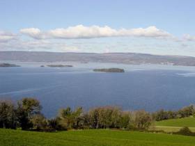
#Angling - Inland Fisheries Ireland (IFI) is currently carrying out a fish stock survey on Lough Derg to assess the current status of the fish populations in the lake.
The survey began on Monday 13 June and continues till Friday 1 July. It involves the netting of over 200 sites throughout Lough Derg and Parteen reservoir.
Four different types of survey nets are being used. Many of these survey nets are being set on the lake bed but a small proportion are being set as floating survey nets on the surface. A hydroacoustic survey of the deeper parts of the lake is also being undertaken.
The fisheries research survey will be conducted by IFI under the supervision of Inland fisheries research staff and will include a total of five boat crews with one of these working at night.
The survey will provide a range of information on the fish stocks in the lake, such as size distributions of fish captured, age and growth information for all species, diet of selected species, and catch per unit effort (CPUEs) for each fish species.
It will also provide information on the status of pollan, a rare and endangered fish species. In addition, samples for genetic analyses of brown trout and pike and other species will be taken.
The survey crews will be very visible on Lough Derg over the next few weeks and all sets of nets will be marked with distinctive buoys labelled ‘IFI Survey’.
Any anglers or other lake users are asked to be vigilant if out and about on the lake over the next few weeks and to avoid snagging in the nets.
For more information see the Lough Derg survey FAQ on the IFI website HERE.
Marine Notice: Demersal Monkfish & Megrim Survey Off North Coast
#MarineNotice - The latest Marine Notice from the Department of Transport, Tourism and Sport (DTTAS) advises that the Marine Institute is carrying out a monkfish and megrim trawl survey off the north of Ireland between Friday 26 February and Sunday 6 March 2016.
The survey consists of a maximum of 45 fishing stations of one-hour duration each in ICES (International Council for Exploration of the Sea) area VIa.
Bottom trawling will take place within a 3nm radius of the locations detailed in Marine Notice No 7 of 2016, a PDF of which is available to read or download HERE.
The survey will be conducted by the RV Celtic Explorer (Callsign EIGB), which will display all appropriate lights and signal during the survey and will also be listening on VHF Channel 16. The vessel will be towing a commercial monkfish demersal trawl during fishing operations.
The Marine Institute requests commercial fishermen to keep a 3 nm area around the tow points clear of all commercial gear during the period.
While there is no statutory provision for the loss of fishing gear, the Marine Institute will make every effort to avoid gear adequately marked according to legislation that may have drifted into the notified areas.
In the event that a fisherman has static gear or other obstructions within 3mn of the points listed, it is the responsibility of the owner to notify the survey managers or vessel directly using the contact information provided.
Inland Fisheries Ireland Launches Stakeholder Survey Programme
Inland Fisheries Ireland (IFI) has today launched a stakeholder survey programme to help the organisation to understand the opinions and attitudes of its stakeholders and to provide an effective service that will meet their needs and expectations into the future.
The programme is a key component of the National Strategy for Angling Development and forms part of a continuing examination of the recreational angling sector in Ireland. A series of surveys is planned to take place throughout 2016. Some of the key areas that will be examined during this programme include: IFI field operations; Irish angling participation; Irish angling expenditure patterns; Irish fisheries research; and the intrinsic benefits of angling in Ireland. The first survey, launched today, looks at IFI’s communication with stakeholders.
Stakeholders include state agencies, government departments, NGOs, anglers, tourism providers, consultants, researchers and all individuals or organisations interested in the inland fisheries sector.
Announcing the survey programme, CEO of Inland Fisheries Ireland, Dr Ciaran Byrne, said: “The programme of surveys is an important step to effect IFI’s commitment to stakeholder engagement, as outlined in its recently published National Strategy for Angling Development and its ongoing collaborative and partnership approach to inland fisheries conservation, protection and management.
“The first survey, on stakeholder communication, was developed to provide an opportunity for individuals and organisations to share their feedback. This feedback will be used to gain a better understanding of how IFI is viewed by its stakeholders and to shape and inform IFI’s communication strategy into the future. Resources within IFI remain limited but we are looking at ways to make our communication more efficient, which will improve our working relationships with stakeholders; increase our mutual knowledge; and create an environment where we can work together more purposefully and effectively.”
IFI will notify stakeholders of the surveys via its websites, social media, press releases, email and through staff members. Responses from individuals or organisations who consider themselves to be stakeholders are welcome. Participation is on a voluntary basis and the first survey is available online here
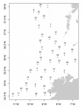
#MarineNotice - The latest Marine Notice from the Department of Transport, Tourism and Sport (DTTAS) advises that a Marine Institute monkfish and megrim trawl survey will be carried out off the west and southwest coasts of Ireland between 4 and 24 January 2016.
The survey consists of a maximum of 70 fishing stations of one-hour duration each in ICES (International Council for Exploration of the Sea) areas VIIb, c,g, h,j.
Approximate positions for these hauls are given in Figure 1 and Table 1 included in Marine Notice No 52 of 2015, a PDF of which is available to read or download HERE.
Bottom trawling will take place within a 3-nautical0mile radius of these locations.
The survey will be conducted by the RV Celtic Explorer (Callsign: EIGB). The vessel will display all appropriate lights and signal during the survey and will also be listening on VHF Channel 16.
She will be towing a commercial monkfish demersal trawl during fishing operations. The Marine Institute would request commercial fishermen to keep a 3-nautical-mile area around the tow points clear of all commercial gear during the period.
While there is no statutory provision for the loss of fishing gear, the Marine Institute will make every effort to avoid gear adequately marked according to legislation (Articles 9-17 of EU Regulation 404-2011) that may have drifted into the notified areas.
In the event that a fisherman has static gear or other obstructions within 3 nautical miles of the points listed above, it is the responsibility of the owner to notify the survey managers or vessel directly via the following contacts:
- Aodhan Fitzgerald, Marine Institute: 087 248 8765
- Hans Gerritsen: [email protected]
Biosecurity Survey For Canoeists & Kayakers
#Canoeing - A new survey that aims to gather information on the current level of awareness of invasive species and their negative impacts among canoeing, kayaking and other paddle sports enthusiasts was launched earlier this week.
The survey is being co-ordinated by Ronan Cooney, a scientist and avid paddler, and Dr Joe Caffrey in conjunction with Inland Fisheries Ireland and Canoeing Ireland.
Many invasive species can survive for long periods out of water, in damp conditions, and can easily be transferred from one watercourse to another as paddlers move around the country.
In Europe it is estimated that 7% of invasive species were introduced by leisure activities (hiking, angling, boating, SCUBA diving and rowing), with the aquaculture (24%), fisheries interests (11%) and the ornamental plant sectors (10%) being the major vectors.
“Invasive species are regarded as being the second greatest threat to biodiversity after habitat destruction," says Dr Caffrey. "These invasive species can be seriously harmful to biodiversity and to ecosystem services in the country. The latter are estimated to be worth over €250 million per annum to Ireland.”
The risk posed to angling and waterways in general by invasive species is very significant. Angling in Ireland is estimated to be worth €755 million to the Irish economy. But a report published in 2013 estimates the cost of invasive species to the tourism and recreation sector to be in the region of €10 million. This sector employs 180,000 people and is worth €5 billion to the Irish economy.
Inland Fisheries Ireland and Canoeing Ireland, the national governing body of paddle sports in Ireland, have been collaborating proactively to reduce the potential spread of invasive species through paddle sports by producing guidelines for the disinfection of paddle sport equipment, the provision of wash-down facilities at major events, and workshops on raising awareness of invasive species.
It is recognised that recreational water users have the potential to be a vector for the spread of invasive species. According to a recent publication in the UK, the potential threat posed by canoeists and anglers for the spread of invasive species is growing.
As an example, some 78.5% of canoeists and 64% of anglers used their equipment in more than one watercourse within a fortnight, meaning that the potential for spread of these species on damp clothing or paddling equipment is high.
The data provided from the survey "will lead to the development of more effective operational practices and behaviours among paddlers and organising bodies, while also making water users aware of the potential negative effects that their activities could have on Irish aquatic ecosystems," says Dr Caffrey.
Dr Kieran McKevitt of Canoeing Ireland adds: “The survey will help us see how our work has improved awareness of invasive species since we started our collaboration with IFI over two years ago and see how paddlers have changed their habits in relation to gear and boat washing."
The survey can be found HERE. For more information on invasive species, visit the Inland Fisheries Ireland website. For more on the survey contact [email protected].
One Week To Go In Coastwatch Survey 2015
#Coastwatch - There's still a week left for Coastwatch volunteers to participate in the annual Coastwatch Survey for 2015, which this year has a special focus on the new Dublin Bay Biosphere.
Since 15 September volunteers have taken on one or more 'survey units' – 500m of shore – to do an 'eco-audit' of Ireland's shoreline at low tide. Details are available HERE.
It's hoped that the survey will break the 1,000-unit barrier by the last day next Thursday 15 October – while also encouraging the public to experience the particularly low spring tides at this time of year, revealing much more of our vibrant marine biodiversity.
Such discoveries could even be record-breaking, like the massive honeycomb reef found by Coastwatch volunteers in the Waterford Estuary this past summer.
Survey Your Local Waterway For Daubenton's Bat This August
#InlandWaters - 2015 marks the tenth year of the All Ireland Daubenton's Bat Waterway Survey – and Waterways Ireland and Bat Conservation Ireland are seeking volunteers across the island to take part in this year's survey over two nights in August.
Free training at a number of different centres began in June and will continue during July (for dates and details see HERE). This training will involve an indoor lecture followed by a practical session using bat detectors on a local river.
The survey is part a monitoring scheme recording the activity of the Daubenton's bat. These yearly surveys allow us to determine whether the population of this bat species is increasing or decreasing.
The more volunteer teams, the more accurate the information will be. In 2014, 252 waterways were surveyed across the island. Your help is needed to increase coverage for the island.
The Daubenton's bat is known as the water bat because of its preference to roost and feed close to water such as rivers and lakes. It is easy to identify because of all of our 10 species of bat, it is the only species that will be seen continuously skimming the water surface as it is feeding on insects.
Surveyors will be in teams of two people. Bat Conservation Ireland will provide the use of a bat detector for the survey. No prior experience is needed.
The All Ireland Daubenton's Bat Waterway Survey is funded by the National Parks and Wildlife Service (NPWS), the Department of Environment, Heritage and Local Government, and the Northern Ireland Environment Agency (NIEA).
If you would like more information or would like to register, visit the Bat Conservation Ireland website HERE.
Trans-Atlantic Mapping Survey Launched
#survey – Today, a multi-national team of European, Canadian, and American ocean mapping experts launch the first trans-Atlantic mapping survey under the Atlantic Ocean Research Alliance.
The survey is one of the first projects to be launched by the Alliance, formed in May 2013 following the Galway Statement on Atlantic Ocean Cooperation, whose goals are to join resources of its three signatories to better understand the North Atlantic Ocean and to promote the sustainable management of its resources.
Under this new era of cooperation on ocean research, Canada's Fisheries and Marine Institute of Memorial University of Newfoundland will use the Irish research vessel, RV Celtic Explorer, to map the seafloor between St. John's, Newfoundland and Labrador, Canada and Galway, Ireland.
The Government of Newfoundland and Labrador has invested approximately $5 million in RV Celtic Explorer expeditions since 2010 to support fisheries science activities. The vessel has just completed this year's fisheries survey and is returning to Ireland providing the additional opportunity for this trans-Atlantic mapping survey.
Together, with scientists from Ireland's national seabed mapping programme, INFOMAR, at the Marine Institute and Geological Survey of Ireland, and the United States' National Oceanic and Atmospheric Administration (NOAA), and the Portuguese Institute for Sea and Atmosphere (IPMA), the team will use multi-beam echo sounders onboard the vessel to collect ocean mapping data during the transect.
The team will gather information on the physical characteristics of the seafloor, such as water depth, hardness, roughness, and the presence of geohazards. The structure and composition of the near subsurface are key considerations for shipping safety, development-related seabed engineering and sustainable fisheries. The survey will broadly follow the great circle route between Ireland and Newfoundland where the first trans-Atlantic cable was deployed in 1857. The team hopes to map the location where the cable was dropped in the mid-Atlantic, which happened to coincide with the most dramatic topographic feature in the North Atlantic, the Charlie Gibbs Fracture Zone.
"The North Atlantic Ocean is crucial to the ecological, economic, and societal health and resilience of North America, Europe and the Arctic regions and the data we collect will be vital to understanding how we move forward together to ensure its sustainability," said Glenn Blackwood, vice-president, Memorial University (Marine Institute). "We are pleased to lend our ocean mapping expertise in this field and contribute in such a meaningful way for our shared benefit."
"We are happy to see Canadian federal, provincial and academic participation in the Atlantic Ocean Research Alliance," said the Honourable Gail Shea, Canada's Minister of Fisheries and Oceans. "The contribution of so many Canadian scientific experts in this important international initiative demonstrates Canada's commitment to the Atlantic Ocean and the Galway Agreement."
"We are proud to be part of the first trilateral expedition under the Atlantic Ocean Research Alliance," said Kathryn Sullivan, U.S. Undersecretary of Commerce for Oceans and Atmosphere and NOAA administrator. "By collaborating fully within this agreement, we will contribute essential scientific knowledge and ensure our shared Atlantic Ocean remains healthy and productive."
"This is an exciting opportunity to identify some important sites on the Atlantic seabed. It marks the beginning of an Atlantic research mapping collaboration between the US, Canada and Europe. We hope to build on next year in 2016 and subsequent years when Ireland's RV Celtic Explorer will be joined by research vessels from Norway and the USA", said Dr. Peter Heffernan, Marine Institute, Ireland.
Speaking at the announcement of the survey in Brussels in April 2015, Simon Coveney, Irish Minister for Agriculture Food and the Marine, said, "Information from the sea-floor is vital to the sustainable management of the Atlantic as well as to important industries such as fisheries, aquaculture and tourism. Ireland has developed a world-leading reputation for sea-bed mapping and is also very committed to the implementation of the Galway Statement and so I am delighted Ireland's state-of the art research vessel-RV Celtic Explorer is the platform for the survey."
"The collaborative mapping of the Atlantic Ocean by Canada, the US and Europe is an important initiative which, as a provincial government, we are proud to support," said the Honourable Darin King, Minister of Business, Tourism, Culture and Rural Development. "This tangible initiative builds on the work my department has been undertaking to facilitate partnerships and economic opportunities between Newfoundland and Labrador and Ireland and on a broader scale between Canada, the US and Europe."
Planning for the survey began in December 2014 when the first seabed mapping event took place in Dublin, Ireland followed by a second meeting in February 2015 in Brussels, Belgium.


 as lead helm, rounds the Fastnet Rock on the way to the overall win in 1987")
