


Displaying items by tag: Dublin Port
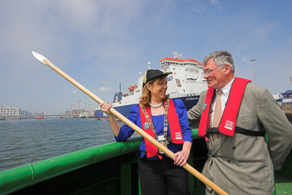
Lord Mayor Casts Spear in Medieval Ceremony at Dublin Port
The Lord Mayor of Dublin and Admiral of Dublin Port, Cllr. Emer Costello, today performed the 522 year old "Casting of the Spear" ceremony at Dublin Port.
The "Casting of the Spear" dates as far back as 1488 when the then Lord Mayor, Thomas Mayler set out on his horse to ride the city's boundaries. Historical records show that he rode out onto the strand as far as a man might ride and from there he cast a spear into the sea. At that time, casting the spear demonstrated the extent of the city boundaries eastwards. From that day onwards each year the Lord Mayor of Dublin re-enacts this medieval ceremony.
The ceremony was re-enacted this morning when the Lord Mayor travelled out into Dublin Bay onboard a Dublin Port tug boat and launched a spear deep into Dublin Bay's cold waters, and once again marked the position of the city boundaries eastwards.
Dublin Port, as an organisation, has a long and remarkable history also, dating back over 300 years. There have been many famous moments and famous visitors in that time.
Captain William Bligh (of "Mutiny on the Bounty" fame) has left a lasting legacy on the port and city. Bligh conducted a study of the tidal flows in Dublin Bay, which led to the construction of the Great South Wall. This construction has resulted in the formation of the present Bull Island, which did not exist in 1800. This amenity is now home to among other amenities two golf courses and an internationally renowned bird sanctuary.
Another interesting historical link with Dublin Port is the tale of the 'Ouzel Galley', an Irish merchant ship that set sail from Dublin Port in 1695. After failing to return for three years it was presumed lost at sea. In 1698 a panel comprising the city's most eminent merchants was set up to settle the question of insurance. The panel's ruling was that the ship had indeed been lost and that its owners and insurers should receive their due compensation. The galley's complement of thirty-seven crew and three officers were declared dead and the insurance was paid out.
However, after a further two years had elapsed, she mysteriously reappeared with her full complement of crew and a valuable cargo of spices and exotic goods. By this stage the insurance had been paid out on the in some cases the 'widows' of the sailors 'lost' at sea had remarried!
Speaking at the ceremony to mark the tradition of 'Casting the Spear' Lord Mayor of Dublin and Admiral of its Port, Cllr. Emer Costello, said: "It's a tremendous honour, as admiral of Dublin Port, to take part in such a treasured, time-honoured local tradition. Over the course of the last 500 years, Dublin Port has played an instrumental role in the development of our capital city. Having Ireland's biggest port so close to the city, in the heart of our capital, adds a great competitive advantage. As a gateway to European and international markets, Dublin Port continues to play a central role in supporting the country's return to economic growth".
Responding to the Admiral of the Port, Dublin Port Company Chief Executive Mr. Enda Connellan said: "Dublin Port is immensely proud of its heritage, its long links with the City and the contribution it has played in the life of this city and country. This ceremony reminds us of where Ireland's largest city has come from over the last 500 years and how the port has played its role in its development, facilitating €35 billion of trade per year and supporting 4,000 real jobs."
Dublin Port Expansion Infill Plan Rejected
The plans to reclaim 21 hectares of land in Dublin Port have been rejected by An Bord Pleanála. The infill, Dublin Port claimed, would have dealt with the imminent capacity issues at the port, and would have increased capacity at the port by 50%,
The plan was rejected on environmental grounds, with the area north of Alexandra Road on the port's eastern extremity designated for expansion.
The Port Company were stunned by the decision, which deemed the proposed infill area would have a detrimental impact on the south Dublin Bay and Tolka Estuary pSPA (proposed special protection area) designated under the EU Birds Directive.
Full Irish Times report on the decision is HERE.
Cruise Liner with Giant Lips Visits Dublin

A Cruise liner berthed on the river Liffey this morning will draw a smile from Dubliners because of the giant red lips and eyes painted on the ship. The Aida Aura is a 203m long vessel carries 1400 passengers and is operated by the German unit of P&O Cruises.
Expedition Liner Visits Cork and Dublin

An interesting visitor to Dublin Bay this morning is the MS Fram, a 500-passenger capacity cruise ship that has been designed with a reinforced hull for cruising arctic waters. The Norwegian ship cruised from Cork overnight. It has a four star rating from www.choosingcruising.co.uk and more details are here. MS Fram is operated by the Hurtigruten ASA Group. The ship made its first maiden voyage to Greenland in May 2007.

Gaff rigged and traditional boats are welcome to join the Dublin Bay Old Gaffers Association in a celebration of traditional sailing and music and craic on the week-end of May 28th-30th. It is part of Poolbeg Yacht and Boat Club's annual regatta and
festival sponsored by Dublin Port Company.
The weekend will begin with registration and reception on Friday night followed by a race in Dublin Bay on Saturday Starting @11:30 at Poolbeg Lighthouse.
On Saturday evening there will be a Hog Roast, music and craic until late.
Sunday will include the Blessing Of The Boats at Poolbeg followed by a Parade of sail up through the East link and the Samuel Beckett Bridges and returning back down to Poolbeg Marina.
Prize giving will take place @17:00 hours in Poolbeg Club house. Sunday evening will conclude with Music and socialising .
Poolbeg Yacht and Boat Club Have Kindly agreed to facilitate all registered and participating boats, free berths on the Marina for the week end.
Dublin Port Company
Dublin Port Company
Dublin Port, the largest port in Ireland, is situated in the heart of Ireland's vibrant capital city. Dublin Port Company's mission is to facilitate the flow of goods, passengers and information through the port.
Dublin Port, as an organisation, has a long and remarkable history, dating back 300 years from 1707 to 2007. There have been many famous moments and famous visitors in that time Captain William Bligh's (of 'Mutiny on the Bounty' fame) involvement in the Port in 1800 has left a lasting legacy.
Bligh conducted a study of the tidal flows in Dublin Bay, which led to the construction of the Great South Wall. This construction has resulted in the formation of the present Bull Island, which did not exist in 1800.
Another famous person, involved in the development of the Port was the famous Port engineer Bindon Blood Stoney. He designed the diving bell now located on Sir John Rogerson's Quay, which was used in the construction of the North Wall Extension. (Pictured: sugar storage at Custom House Docks).

Dublin Bay Guidance Notes for Leisure Craft
For all recreational craft using Dublin Port and Bay, compiled by Dublin Port Company in consultation with local yacht and boat clubs
Facts to bear in mind:
1. As both the number of large commercial ships and recreational craft using Dublin Port is increasing it is essential that close quarter situations do not arise.
2. Commercial vessels using Dublin Port or Dun Laoghaire Port normally have a qualified pilot or certified master with proven local knowledge on board. They 'listen out' on VHF channel 12 when in Dublin Port’s jurisdiction.
3. Commercial vessels will follow the routes designated in the attached illustration. All recreational craft when obliged to navigate within such areas should do so with extreme caution following the Int. Collisions Regulations.
4. Large conventional commercial craft travel at a manoeuvering speeds of between 8 to 15 knots whilst within the ports jurisdiction. The lower limit varies from ship to ship and is 'as safe navigation permits'.
5. Ships will be traveling faster than you may estimate, even in congested waters.
6. Ships that are light or partially loaded, particularly in windy conditions, will require a higher minimum speed to remain under full control.
7. A large ship visible on the horizon may take no more than 10 minutes to reach you under clear conditions, under hazy conditions this time could be much less. At 10 knots a ship will travel a nautical mile in 6 minutes, at 15 knots it takes only 4 minutes to travel one nautical mile.
8. A large deep draught ship cannot easily avoid small craft in a narrow channel. It is up to leisure craft to keep clear (see Rule 9 Int. Collision Regs excerpt at end of this page).
9. A ship slowing down does not steer very well. It requires the action of its propeller to respond. When the propellor is going 'astern' the ship’s steering will be adversely affected.
10. As well as large cargo ships, a variety of working craft also use the port, tugs, pilot cutters, dredgers, fast ferries, barges under tow etc. In particular a towing line may be partly submerged and therefore potentially dangerous to other craft passing too close.
What should you do?
1. Avoid sailing in the buoyed channel area, avoid sailing within 0.5 nautical mile of the Dublin Bay buoy and in the separation schemes, (see illustration). This is especially critical in periods of reduced visibility. When obliged to cross the fairway, cross at right angles to the traffic flow. Also obey rule 9 of the Collision Regulations by either keeping to the starboard side of the channel or if the water depth allows outside the buoyed channel.
2. Keep a good lookout. Be aware of all ship movements, especially astern of you.
3. Do not underestimate the speed of ships. Allow plenty of time to take effective evasive action in the vicinity of large ships.
4. Be visible. At night make sure your navigation lights can be clearly seen. If you see the navigation lights of a vessel approaching and you think that he has not seen you, get out of the way. Also use a torch or search-light to illuminate the sails (if appropriate). Remember (as indicated in the attached illustration), from the bridge of a loaded container ship or large tanker the captain/pilot may lose sight of you a half a nautical mile ahead, although you can see that ship clearly from your vessel at all times.
5. Keep watch at night. You may have difficulty seeing a large ship approach, even on a clear night. In reduced visibility you may have little warning of its approach. If you see a black shadow against shore lights or as a growing shadow, at that point a close quarter situation is already imminent. Remember you cannot be easily seen at night (particularly in a background of lights) and judging distances at night can prove difficult.
6. Watch the ships navigation lights. If you see both ships sidelights you are dead ahead, follow the Int. Collision Regs. and any alteration of course should be early, substantial and be visible to the approaching ship. Be aware that ships alter course at the Dublin Bay buoy and No.3/No.4 buoys. Be aware of your position and the position of other vessels around you at all times.
7. Know the whistle signals (see illustration). Five or more short and rapid blasts on the ships whistle indicates the ship is in doubt about your action or the lack thereof. Check immediately if this signal was meant for you, if so take immediate and appropriate action. Three short blasts means 'my engines are going astern' one short blast means 'I am altering my course to starboard'. Two short blasts "I am altering my course to port".
8. Keep your VHF tuned to channel 12 the port working frequency, and have the volume high enough to hear above the noise of the engine. Listen for traffic information from Dublin Port V.T.S. Only if you are the controlling vessel in a flotilla of other vessels, and you observe a hazardous situation developing, or in the event of an emergency developing within the ports jurisdiction, you should transmit on VHF channel 12.
Remember CH 12 is Dublin Port’s primary working channel and used to manage port traffic. No private or unneccessary communications to take place on this channel.

Area 1 - from Dublin Bay Buoy to Poolbeg Lighthouse
Small craft shall not navigate inside the fairway and should remain outside the line of buoys. If it is necessary to cross the fairway, crossing should be at right angles.
Area 2 - Poolbeg Lighthouse to No. 14 Buoy
Small craft shall comply with the International Regulations for Prevention of Collisions at Sea and shall keep as near to the outer limit of the channel which lies on her starboard side as is safe and practicable. Rule 9 does not apply outside the channel and craft may pass outside the buoys when and where it is safe to do so. If it is necessary to cross the channel, e.g. to enter area 3, crossing should be at right angles, at a position abeam of the ESB Jetty (Berth 48).
Area 3 - No. 14 Buoy to the west
All small craft should pass along the south side of the channel, remaining as far as is practicable to that side.
General
All craft shall operate under power when within areas 2 and 3, but may additionally raise their sails outside the channel but not in the channel.
1. No sailing in the channel, craft should only cross at right angles when it is safe to do so.
2. Maintain a listening watch on channel VHF 12 and avoid unnecessary communication.
Keep a sharp lookout and keep clear of all shipping.
Attention of all skippers is drawn to the annual Notice to Mariners No. 7 concerning small craft.
Capt. David T. Dignam, Harbour Master. 31st March 2006
Collision Avoiding Check List
Avoid the busy shipping channels and routes. Cross them at right angles and as quickly as possible after checking that it is safe to do so. Recreational users of the port area are particularly requested to be familiar with the Int. Collision Regulations (particularly Rule 9), Dublin Port Bye Laws, Small Craft (Leisure) Regulations (see chartlet) and Local Notices to Mariners (particularly No.7). Information is also available on the Dublin Port web site, www. dublinport.ie
Remember:
• Keep a good lookout, particularly at night
• Do not under-estimate the speed of ships
• Be visible
• Watch the lights of other vessels
• Know the whistle signals
• Keep your VHF tuned to channel 12
• Obey any instructions given by Dublin Port VTS. They are also interested in your safety.
International Regulations for the Prevention of Collisions at Sea
Rule 9 - Narrow Channels (Excerpt)
(a) A vessel proceeding along the course of a narrow channel or fairway shall keep as near to the outer limit of the channel or fairway, which lies on her starboard side as, is safe and practicable
(b) A vessel of less than 20 metres in length or a sailing vessel shall not impede the passage of a vessel which can safely navigate only within a narrow channel or fairway.
(c) A vessel engaged in fishing shall not impede the passage of any other vessel navigating within a narrow channel or fairway.
(d) A vessel shall not cross a narrow channel or fairway if such crossing impedes the passage of a vessel which can safely navigate only within such channel or fairway. The latter vessel may use the sound signal prescribed in Rule 34(d) or in doubt as to the intention of the crossing vessel.
Rule 10 – Traffic Separation Schemes (Excerpt)
(i) A vessel of less than 20 metres in length or a sailing vessel shall not impede the safe passage of a power-driven vessel following a traffic lane.

Dublin Port Company Port Centre, Alexandra Road, Dublin 1
Tel: 353 1 887 6000, Email: [email protected], fax 353 1 855 7400


 as lead helm, rounds the Fastnet Rock on the way to the overall win in 1987")


