Menu

Ireland's sailing, boating & maritime magazine

Dublin Bay Boating News and Information

Lord Mayor Casts Spear in Medieval Ceremony at Dublin Port

22nd June 2010
Lord Mayor Casts Spear in Medieval Ceremony at Dublin Port

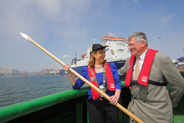
The Lord Mayor of Dublin and Admiral of Dublin Port, Cllr. Emer Costello, today performed the 522 year old "Casting of the Spear" ceremony at Dublin Port.

The "Casting of the Spear" dates as far back as 1488 when the then Lord Mayor, Thomas Mayler set out on his horse to ride the city's boundaries. Historical records show that he rode out onto the strand as far as a man might ride and from there he cast a spear into the sea. At that time, casting the spear demonstrated the extent of the city boundaries eastwards. From that day onwards each year the Lord Mayor of Dublin re-enacts this medieval ceremony.

The ceremony was re-enacted this morning when the Lord Mayor travelled out into Dublin Bay onboard a Dublin Port tug boat and launched a spear deep into Dublin Bay's cold waters, and once again marked the position of the city boundaries eastwards.

Dublin Port, as an organisation, has a long and remarkable history also, dating back over 300 years. There have been many famous moments and famous visitors in that time.

Casting_of_the_Spear-21-06-2010-IMG_7123-01_96


Pictured at the re-enactment of the 522 year tradition of 'Casting of the Spear' were: Honorary Admiral of Dublin Port and Lord Mayor of Dublin Emer Costello and Dublin Port Company Chief Executive Enda Connellan. Photo: Denis Bergin

Captain William Bligh (of "Mutiny on the Bounty" fame) has left a lasting legacy on the port and city. Bligh conducted a study of the tidal flows in Dublin Bay, which led to the construction of the Great South Wall. This construction has resulted in the formation of the present Bull Island, which did not exist in 1800. This amenity is now home to among other amenities two golf courses and an internationally renowned bird sanctuary.

Another interesting historical link with Dublin Port is the tale of the 'Ouzel Galley', an Irish merchant ship that set sail from Dublin Port in 1695. After failing to return for three years it was presumed lost at sea. In 1698 a panel comprising the city's most eminent merchants was set up to settle the question of insurance. The panel's ruling was that the ship had indeed been lost and that its owners and insurers should receive their due compensation. The galley's complement of thirty-seven crew and three officers were declared dead and the insurance was paid out.

However, after a further two years had elapsed, she mysteriously reappeared with her full complement of crew and a valuable cargo of spices and exotic goods. By this stage the insurance had been paid out on the in some cases the 'widows' of the sailors 'lost' at sea had remarried!
Speaking at the ceremony to mark the tradition of 'Casting the Spear' Lord Mayor of Dublin and Admiral of its Port, Cllr. Emer Costello, said: "It's a tremendous honour, as admiral of Dublin Port, to take part in such a treasured, time-honoured local tradition. Over the course of the last 500 years, Dublin Port has played an instrumental role in the development of our capital city. Having Ireland's biggest port so close to the city, in the heart of our capital, adds a great competitive advantage. As a gateway to European and international markets, Dublin Port continues to play a central role in supporting the country's return to economic growth".

Responding to the Admiral of the Port, Dublin Port Company Chief Executive Mr. Enda Connellan said: "Dublin Port is immensely proud of its heritage, its long links with the City and the contribution it has played in the life of this city and country. This ceremony reminds us of where Ireland's largest city has come from over the last 500 years and how the port has played its role in its development, facilitating €35 billion of trade per year and supporting 4,000 real jobs."


Published in Dublin Bay
Afloat.ie Team

About The Author

Afloat.ie Team

Email The Author

Afloat.ie is Ireland's dedicated marine journalism team.

Have you got a story for our reporters? Email us here.

We've got a favour to ask

More people are reading Afloat.ie than ever thanks to the power of the internet but we're in stormy seas because advertising revenues across the media are falling fast. Unlike many news sites, we haven’t put up a paywall because we want to keep our marine journalism open.

Afloat.ie is Ireland's only full–time marine journalism team and it takes time, money and hard work to produce our content.

So you can see why we need to ask for your help.

If everyone chipped in, we can enhance our coverage and our future would be more secure. You can help us through a small donation. Thank you.

Direct Donation to Afloat button

Dublin Bay

Dublin Bay on the east coast of Ireland stretches over seven kilometres, from Howth Head on its northern tip to Dalkey Island in the south. It's a place most Dubliners simply take for granted, and one of the capital's least visited places. But there's more going on out there than you'd imagine.

The biggest boating centre is at Dun Laoghaire Harbour on the Bay's south shore that is home to over 1,500 pleasure craft, four waterfront yacht clubs and Ireland's largest marina.

The bay is rather shallow with many sandbanks and rocky outcrops, and was notorious in the past for shipwrecks, especially when the wind was from the east. Until modern times, many ships and their passengers were lost along the treacherous coastline from Howth to Dun Laoghaire, less than a kilometre from shore.

The Bay is a C-shaped inlet of the Irish Sea and is about 10 kilometres wide along its north-south base, and 7 km in length to its apex at the centre of the city of Dublin; stretching from Howth Head in the north to Dalkey Point in the south. North Bull Island is situated in the northwest part of the bay, where one of two major inshore sandbanks lie, and features a 5 km long sandy beach, Dollymount Strand, fronting an internationally recognised wildfowl reserve. Many of the rivers of Dublin reach the Irish Sea at Dublin Bay: the River Liffey, with the River Dodder flow received less than 1 km inland, River Tolka, and various smaller rivers and streams.

Dublin Bay FAQs

There are approximately ten beaches and bathing spots around Dublin Bay: Dollymount Strand; Forty Foot Bathing Place; Half Moon bathing spot; Merrion Strand; Bull Wall; Sandycove Beach; Sandymount Strand; Seapoint; Shelley Banks; Sutton, Burrow Beach

There are slipways on the north side of Dublin Bay at Clontarf, Sutton and on the southside at Dun Laoghaire Harbour, and in Dalkey at Coliemore and Bulloch Harbours.

Dublin Bay is administered by a number of Government Departments, three local authorities and several statutory agencies. Dublin Port Company is in charge of navigation on the Bay.

Dublin Bay is approximately 70 sq kilometres or 7,000 hectares. The Bay is about 10 kilometres wide along its north-south base, and seven km in length east-west to its peak at the centre of the city of Dublin; stretching from Howth Head in the north to Dalkey Point in the south.

Dun Laoghaire Harbour on the southside of the Bay has an East and West Pier, each one kilometre long; this is one of the largest human-made harbours in the world. There also piers or walls at the entrance to the River Liffey at Dublin city known as the Great North and South Walls. Other harbours on the Bay include Bulloch Harbour and Coliemore Harbours both at Dalkey.

There are two marinas on Dublin Bay. Ireland's largest marina with over 800 berths is on the southern shore at Dun Laoghaire Harbour. The other is at Poolbeg Yacht and Boat Club on the River Liffey close to Dublin City.

Car and passenger Ferries operate from Dublin Port to the UK, Isle of Man and France. A passenger ferry operates from Dun Laoghaire Harbour to Howth as well as providing tourist voyages around the bay.

Dublin Bay has two Islands. Bull Island at Clontarf and Dalkey Island on the southern shore of the Bay.

The River Liffey flows through Dublin city and into the Bay. Its tributaries include the River Dodder, the River Poddle and the River Camac.

Dollymount, Burrow and Seapoint beaches

Approximately 1,500 boats from small dinghies to motorboats to ocean-going yachts. The vast majority, over 1,000, are moored at Dun Laoghaire Harbour which is Ireland's boating capital.

In 1981, UNESCO recognised the importance of Dublin Bay by designating North Bull Island as a Biosphere because of its rare and internationally important habitats and species of wildlife. To support sustainable development, UNESCO’s concept of a Biosphere has evolved to include not just areas of ecological value but also the areas around them and the communities that live and work within these areas. There have since been additional international and national designations, covering much of Dublin Bay, to ensure the protection of its water quality and biodiversity. To fulfil these broader management aims for the ecosystem, the Biosphere was expanded in 2015. The Biosphere now covers Dublin Bay, reflecting its significant environmental, economic, cultural and tourism importance, and extends to over 300km² to include the bay, the shore and nearby residential areas.

On the Southside at Dun Laoghaire, there is the National Yacht Club, Royal St. George Yacht Club, Royal Irish Yacht Club and Dun Laoghaire Motor Yacht Club as well as Dublin Bay Sailing Club. In the city centre, there is Poolbeg Yacht and Boat Club. On the Northside of Dublin, there is Clontarf Yacht and Boat Club and Sutton Dinghy Club. While not on Dublin Bay, Howth Yacht Club is the major north Dublin Sailing centre.

© Afloat 2020