


Displaying items by tag: Marine Notice
2020’s Irish Groundfish Survey Gets Under Way
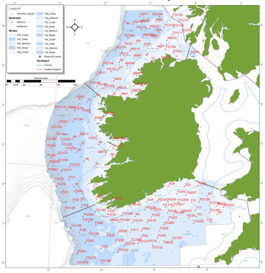
This year’s Irish Groundfish Survey (IGFS 2020) of the North, West and South Coasts of Ireland is set to commence today, Sunday 25 October.
Carried out by the Marine Institute, the IGFS is a demersal trawl survey consisting of around 170 fishing hauls, each of of 30 minutes’ duration, in ICES areas VIa, VIIb, VIIg and VIIj.
As part of the requirements for the 2020 survey, fishing will take place within a two-nautical-mile radius of indicated positions.
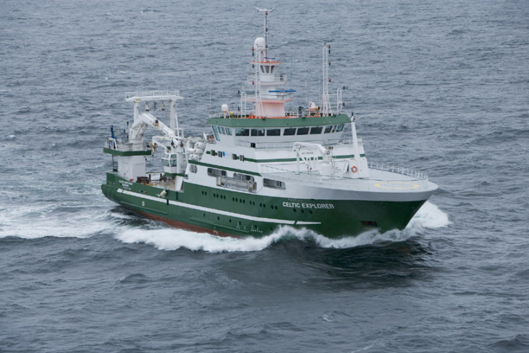
The survey will be conducted by the RV Celtic Explorer (callsign EIGB) which will display appropriate lights and signals.
The vessel will be towing a high headline GOV 36/47 demersal trawl during fishing operations.
Co-ordinates and approximate locations of these hauls are included in Marine Notice No 48 of 2020, a PDF of which is available to download below.
The Marine Institute requests that commercial fishing and other marine operators keep a 2nm area around the tow mid-points clear of any gear or apparatus during the survey period between now and October and Thursday 10 December.
This survey follows the annual Irish Anglerfish and Megrim Survey which was conducted off the West, South West and South Coasts this past February and March.
Marine Notice: ADCP Deployment Off Inis Mór For Highwave Project
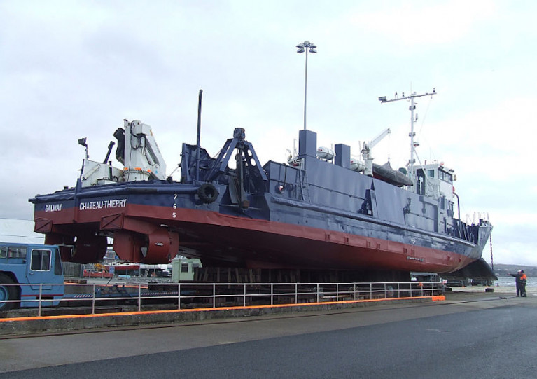
University College Dublin have been set to deploy an Acoustic Doppler Current Profiler (ADCP) off Inis Mór in the Aran Islands between today, Thursday 15 October, and next Wednesday 21 October as part of the Highwave project.
The university previously deployed an ADCP in February as par of the same ocean wave data modelling project.
Thos latest deployment, from the MV Chateau-Thierry (callsign EIHK6), will be some 0.6 nautical miles from Rock Island lighthouse — at 53°08’57.4” N, 009°52’23.4” W. The vessel will display appropriate lights and signals.
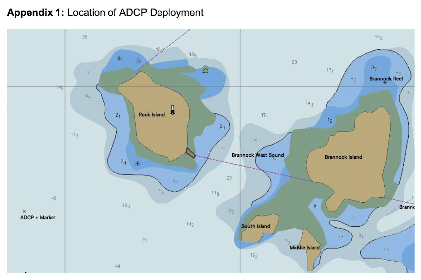
Navigational warnings will be issued by radio when the deployment of the marker buoys takes place. These buoys will be yellow spherical markers, 40cm in diameter and flashing yellow every five seconds.
Irish Coast Guard Issues Reminder On Planned Changes To VHF Channels
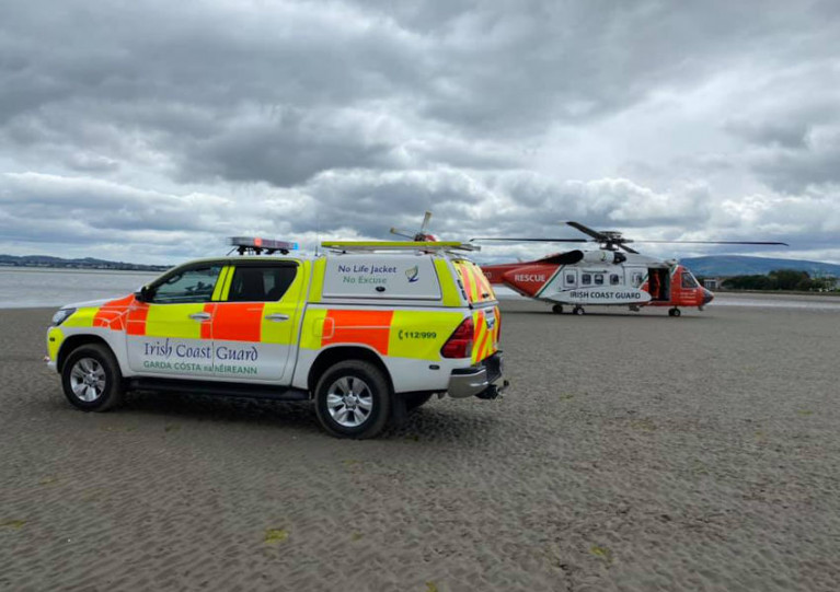
The Irish Coast Guard is reminding mariners of its planned changes to the VHF working channels currently used for communications with the public.
As previously reported on Afloat.ie, upgrades of radio equipment at a number of remote locations around the coast will be made over a 10-week period scheduled to begin tomorrow, Tuesday 6 October.
Notwithstanding the changes, which are also outlined in the previous report, Channel 16 will remain available at each site for distress, safety and calling.
Channel 67 is also available when required but may not be actively monitored at all times.
Updates as the work progresses will be made on the coastguard’s social media accounts in Twitter, Facebook and Instagram as well as on the gov.ie and Safety on the Water websites.
Sediment Wave & Sand Bank Survey Continues In South Irish Sea
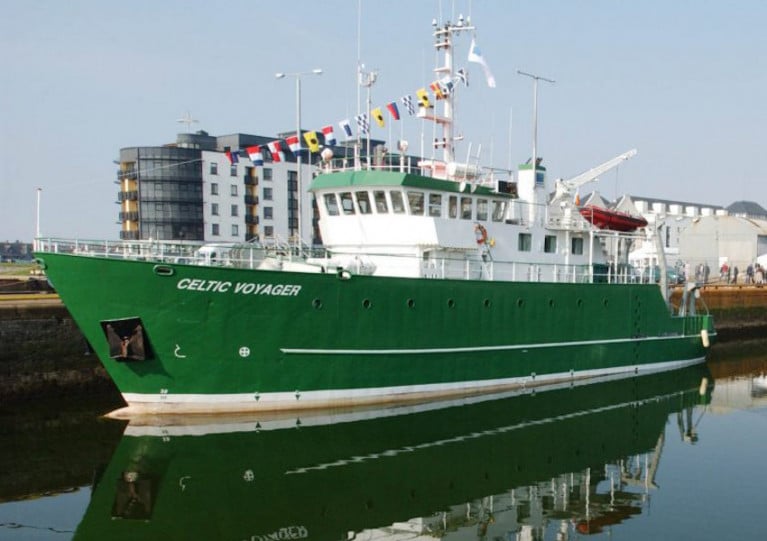
The next legs of the Mobility of Sediment Waves and Sand Banks in the Irish Sea (MOVE) Survey begin tomorrow, Wednesday 23 September, according to the latest Marine Notice from the Irish Maritime Administration.
As previously reported on Afloat.ie, the survey is being carried out in support of ongoing research at the Irish Centre for Research in Applied Geosciences (iCRAG).
The latest two legs of the survey will take place from 23-28 September and from 7-19 October in the south Irish Sea.
Works will be carried out by the RV Celtic Voyager (callsign EQIN) using a variety of equipment and techniques, including ADCP, multibeam sonar and sediment sampling.
All works will be performed on a 24-hour schedule and the vessel will display appropriate lights and signals.
Details of all works entailed and the survey areas are included in Marine Notice No 43 of 2020, a PDF of which is available to download below.
Diving Operations At Kinsale & Seven Heads Gas Fields Next Month
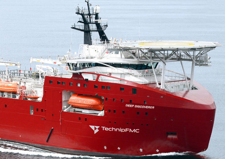
Diving operations will take place at the Kinsale and Seven Heads gas fields early next month for decommissioning work on and around the subsea infrastructure.
Kinsale Energy says the works — undertaken by the dive support vessel Deep Discoverer (callsign C6EB7) — will begin on Friday 2 October and continue for around 30 days, weather depending.
Full details of co-ordinates of the affected areas are included in Marine Notice No 42 of 2020, a PDF of which is attached below.
Marine Notice Highlights Importance Of Voyage Planning For Fishing Vessels
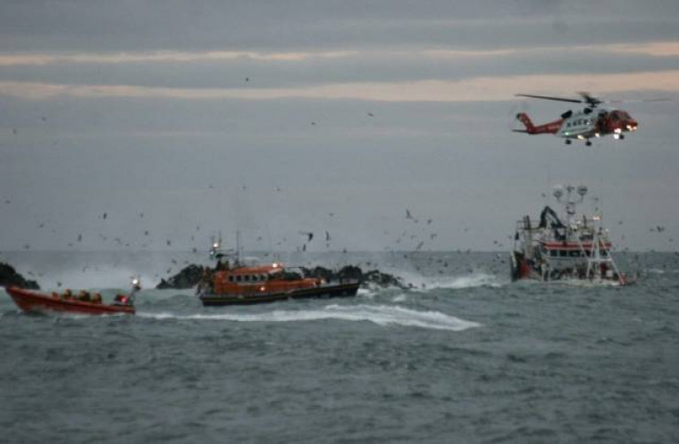
The latest Marine Notice from Department of Transport highlights the importance of planning seagoing voyages, especially those involved in fishing.
It follows a recommendation from the Marine Casualty Investigation Board (MCIB) this summer in its report on the sinking of a West Cork fishing vessel in Ardglass, Co Down last year.
As previously reported on Afloat.ie, the Dillon Owen was entering Ardglass harbour to land its catch and refuel on 23 October last when it grounded, lost power and then drifted onto rocks.
All five crew on board were uninjured and airlifted to safety, but the vessel could not be towed off the rocks at Phennick Point and sank over the following days.
The MCIB report noted that the crew lost valuable time to drop their primary anchor — which would likely have avoided the drift into the rocks in the shallow harbour — by instead focusing on attempts to release the trawl doors.
Also suggested in the report was a call on the Minister for Transport to issue a Marine Notice for fishing vessel owners and operators to develop contingency plans and drills for such incidents.
Full details are available in Marine Notice No 41 of 2020, a PDF of which is available to download below.
Upcoming Electrical Fault-Finding Works At Corrib Gas Field
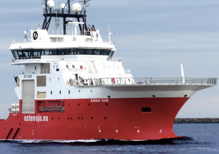
Mariners in the vicinity of the Corrib Gas Field are advised of electrical fault-finding works at the field’s subsea infrastructure set for later this month.
Works conducted from the Edda Sun (callsign LARF7) will begin on or around next Friday 18 September and will last for up to 10 days. The work vessel will be listening on VHF channel 16 throughout the project.
Details of co-ordinates of the search and repair area are included in Marine Notice No 39 of 2020, which is attached below.
Applications Open For Latest Radio Surveyors Panel
A call for applications has been launched for the latest three-year panel of radio surveyors.
As with previous iterations, this panel will carry out statutory radio surveys on Irish seagoing vessels, including fishing vessels greater than 15m LOA, for compliance with the relevant requirements.
Interested parties can access the tender information, and must submit their application, via the eTenders portal before 3pm on Monday 28 September.
More details are available in Marine Notice No 40 of 2020 which is attached below.
Irish Maritime Administration Launches Engagement Survey

A new survey from the Irish Maritime Administration (IMA) of the Department of Transport encourages feedback regarding its communication with stakeholders and service users.
Marine Notices are one method used to communicate important information by the IMA and its divisions, which include the Marine Survey Office, Maritime Transport Division, Maritime Safety Policy Division, Marine Mercantile Office, Maritime Service Division and the Irish Coast Guard.
“The survey is an opportunity for you to provide helpful feedback and will assist the IMA to improve how communicate sand engages with its many and varied stakeholders and service users,” the administration says.
Survey For Proposed Undersea Cable From Ireland To Iceland
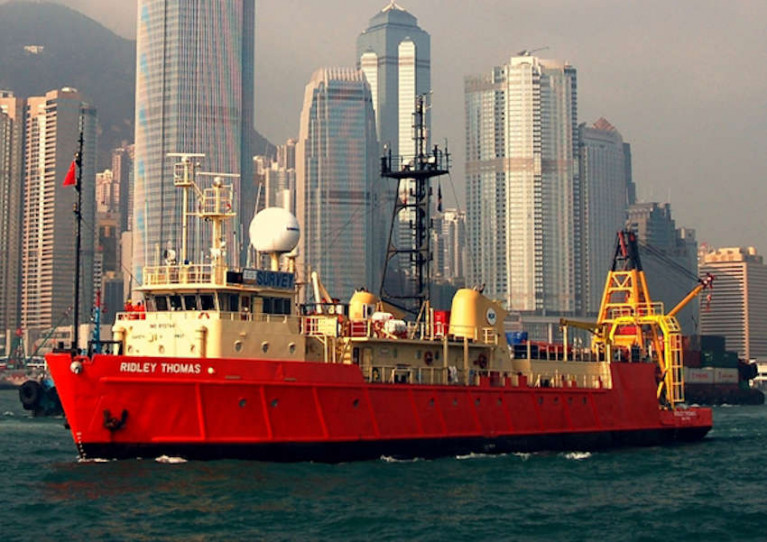
Survey works for a proposed new submarine communications cable between Ireland and Iceland will be conducted from next week.
The hydrographic survey is due to take place from next Thursday 10 September and will be completed by early November.
Works during the 24/7 cable route survey will involve the stern deployment of a sonar towfish, tethered with steel cable at varying water depths, to collect geophysical/bathymetric mapping data for the proposed undersea telecommunications cable along a 540km route.
The survey will be conducted from the RV Ridley Thomas (Callsign V7JK2), which will be restricted in its ability to manoeuvre.
All other vessels, including fishing vessels, are requested to maintain distance of at least one nautical mile at all times.
Co-ordinates of the search area as well as relevant contact details are included in Marine Notice No 37 of 2020, which is available to download below.


 skippered by Chris Power Smith")


 with his best mate, getting into battle mood in the North African desert during World War II of 1939-45. Anyone who gets along well with a Jack Russell terrier, while looking so very like superstar actor Liam Neeson before Neeson was born, must have had some redeeming features - even if he was a danger to all when partying in a new kitchen")


