Menu

Ireland's sailing, boating & maritime magazine

Displaying items by tag: Seismometers

#MarineNotice - The latest Marine Notice from the Department of Transport, Tourism and Sport (DTTAS) advises that marine scientists from the Dublin Institute of Advanced Studies (DIAS) are deploying a tsunameter close to the new location of the M4 weather buoy off the Donegal coast.

In addition to the tsunameter, they will also deploy a sub-surface buoy with an acoustic Doppler current profiler (ADCP) mounted on it, as well as pressure sensors clamped to a moored string to measure pressure variations at depth. This system will be deployed in proximity to the tsunameter location but not too close to avoid tangling.

The tsunameter and system used for the ADCP and the pressure string sensors is scheduled to be be deployed imminently from the RV Celtic Voyager (Callsign: EIQN) at latitude 54°59.892 N, longitude 009°58.14 W, at a depth of 119m adjacent to M4 weather buoy.

As this is sensitive scientific equipment, it is requested that fisherman and marine operators engaged in such activities as bottom trawling or laying of static gear avoid the locations concerned to avoid damaging the equipment or damaging fishing gear.

Published in Marine Warning

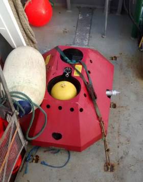
#MarineNotice - The first Marine Notice of 2016 from the Department of Transport, Tourism and Sport (DTTAS) advises that the Dublin Institute for Advanced Studies (DIAS) is deploying 10 Ocean Bottom Seismometers for a period of seven months off the North West Coast of Ireland.

The OBS units will be deployed from the Marine Institute vessel RV Celtic Voyager between 13 and 22 January. They will be free-falled to the bottom and anchored by a 400kg clump weight.

The OBS units in shallow water will have a yellow surface marker buoy and a yellow flashing light with the following characteristics: FL (5) Y 20s and with a range of 2 nautical miles.

Station 1 will be located close to the M4 Weather Buoy which is the subject of a prior marine notice (No 11 of 2007).

As this is sensitive scientific equipment, it is requested that fisherman and marine operators engaged in such activities as bottom trawling or laying of static gear avoid the locations concerned to avoid damaging the equipment or damaging fishing gear.

Full co-ordinates of the OBS locations are included in Marine Notice No 1 of 2016, a PDF of which is available to read or download HERE.

Published in Marine Warning

Cork Harbour Information

It’s one of the largest natural harbours in the world – and those living near Cork Harbour insist that it’s also one of the most interesting.

This was the last port of call for the most famous liner in history, the Titanic, but it has been transformed into a centre for the chemical and pharmaceutical industry.

The harbour has been a working port and a strategic defensive hub for centuries, and it has been one of Ireland's major employment hubs since the early 1900s. Traditional heavy industries have waned since the late 20th century, with the likes of the closure of Irish Steel in Haulbowline and shipbuilding at Verolme. It still has major and strategic significance in energy generation, shipping and refining.

Giraffe wander along its shores, from which tens of thousands of men and women left Ireland, most of them never to return. The harbour is home to the oldest yacht club in the world, and to the Irish Navy. 

This deep waterway has also become a vital cog in the Irish economy.

‘Afloat.ie's Cork Harbour page’ is not a history page, nor is it a news focus. It’s simply an exploration of this famous waterway, its colour and its characters.

Cork Harbour Festival

Ocean to City – An Rás Mór and Cork Harbour Open Day formerly existed as two popular one-day events located at different points on Cork’s annual maritime calendar. Both event committees recognised the synergy between the two events and began to work together and share resources. In 2015, Cork Harbour Festival was launched. The festival was shaped on the open day principle, with Ocean to City – An Ras Mór as the flagship event.

Now in its sixth year, the festival has grown from strength to strength. Although the physical 2020 festival was cancelled due to Covid-19, the event normally features nine festival days starting on the first week of June. It is packed full of events; all made possible through collaboration with over 50 different event partners in Cork City, as well as 15 towns and villages along Cork Harbour. The programme grows year by year and highlights Ireland’s rich maritime heritage and culture as well as water and shore-based activities, with Ocean to City – An Rás Mór at the heart of the festival.

Taking place at the centre of Ireland’s maritime paradise, and at the gateway to Ireland’s Ancient East and the Wild Atlantic Way, Cork is perfectly positioned to deliver the largest and most engaging harbour festival in Ireland.

The Cork Harbour Festival Committee includes representatives from Cork City Council, Cork County Council, Port of Cork, UCC MaREI, RCYC, Cobh & Harbour Chamber and Meitheal Mara.

Marinas in Cork Harbour

There are six marinas in Cork Harbour. Three in Crosshaven, one in East Ferry, one in Monkstown Bay and a new facility is opening in 2020 at Cobh. Details below

Port of Cork City Marina

Location – Cork City
Contact – Harbour Masters Dept., Port of Cork Tel: +353 (0)21 4273125 or +353 (0)21 4530466 (out of office hours)

Royal Cork Yacht Club Marina

Location: Crosshaven, Co. Cork
Contact: +353 (0) 21 4831023

Crosshaven Boatyard Marina

Location: Crosshaven, Co. Cork
Contact: +353 (0)21 4831161

Salve Marina Ltd

Location: Crosshaven, Co. Cork
Contact: +353 (0) 21 4831145

Cork Harbour Marina

Location: Monkstown, Co. Cork
Contact: +353 (0)87 3669009

East Ferry Marina

Location: East Ferry, Co. Cork
Contact: +353 (0)21 4813390

New Cove Sailing Club Marina

(to be opened in 2020)

Location: Cobh, Co. Cork
Contact: 087 1178363

Cork Harbour pontoons, slipways and ramps

Cork City Boardwalk Existing pontoon

Port of Cork 100m. pontoon

Cork city – End of Cornmarket St. steps and slip;

Cork city - Proby’s Qy. Existing limited access slip

Quays Bar & Restaurant, Private pontoon and ramp for patrons, suitable for yachts, small craft town and amenities

Cobh harbour [camber] Slip and steps inside quay wall pontoon

Fota (zoo, house, gardens) Derelict pontoon and steps

Haulbowline naval basin; restricted space Naval base; restricted access;

Spike Island pier, steps; slip, pontoon and ramp

Monkstown wooden pier and steps;

Crosshaven town pier, with pontoon & steps

East Ferry Marlogue marina, Slip (Great Island side) visitors’ berths

East Ferry Existing pier and slip; restricted space East Ferry Inn (pub)
(Mainland side)

Blackrock pier and slips

Ballinacurra Quay walls (private)

Aghada pier and slip, pontoon & steps public transport links

Whitegate Slip

Passage West Pontoon

Glenbrook Cross-river ferry

Ringaskiddy Parking with slip and pontoon Ferry terminal; village 1km.

Carrigaloe pier and slip; restricted space; Cross-river ferry;

Fountainstown Slip

White’s Bay beach

Ringabella beach

Glanmire Bridge and tide restrictions

Old Glanmire - Quay