Menu

Ireland's sailing, boating & maritime magazine

Dublin Bay Boating News and Information

Displaying items by tag: Aids to navigation

The General Lighthouse Authorities (GLA) have announced a review of the Aids to Navigation (AtoN) provision around the coasts of Ireland and Great Britain.

Trinity House will publish the results of the review in 2025, the outcomes of which will inform the GLAs’ work plans for the following five-year period.

The GLA provide a comprehensive and sustainable network of AtoN for General Navigation and are responsible for the Superintendence and Management of Local AtoN provided by Local Lighthouse Authorities.

The GLA has said that they consider user input to be an essential part of this review. Users of AtoN are encouraged to contribute to the review by commenting on:

  • The usefulness and usability of existing AtoN provided by the GLAs.
  • Any proposed requirement for the provision of new AtoN.
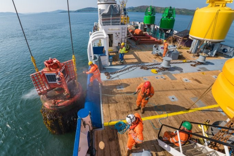
  • The mix of AtoN provided including lighthouses, buoys, beacons, Racons and AIS AtoN.
  • The benefit to users of providing additional data from AtoN such as meteorological data.
  • The effectiveness of systems used to promulgate information relating to AtoN.
  • Any other AtoN related issues.

You can find the full details of how to respond to the Aids to Navigation Review on the Trinity House website. The closing date for responses is Friday 31 May.

Published in Lighthouses

IALA hosts the World Marine Aids to Navigation Day (WATON) which for this year will also be celebrated virtually, writes Jehan Ashmore.

The International Association of Marine Aids to Navigation and Lighthouse Authorities (IALA) is a non-profit, international technical association established in 1957.

Among the role of IALA is to gather together Marine Aids to Navigation authorities, manufacturers, consultants, and, scientific and training institutes from all parts of the world and offers them the opportunity to exchange and compare their experiences and achievements.

In Ireland the event is recognised by the Commissioners of Irish Lights based in Dun Laoghaire Harbour where also today at their headquarters, the Taoiseach launched the National Marine Planning Framework and Maritime Area Planning Bill.  

Irish Lights is responsible for waters north and south and is among three General Lighthouse Authorities (GLA's) also involved in Aids to Navigation (AtoN) around the coast of Britain.

The other GLA's in which Irish Lights works in close co-operation and mutual support is Trinity House (England & Wales) and the Northern Lighthouse Board (Scotland and Isle of Man). 

Everyone is invited to take part this WATON by sharing photos of AtoN's on Social Media so to raise awareness world-wide.

Published in Lighthouses

Lough Key, Erris Bay, Aids to Inland Waterways Navigation

Waterways Ireland wishes to advise masters of vessels that the area of Erris Bay i.e. South of the line from the entrance to Boyle Harbour to Trinity Island to the west point of Drummans Island is closed to navigation.

Works to replace navigations markers is being undertaken and a marine notice will be issued on completion which is expected to be near the end of February 2011.

Waterways Ireland regrets any inconvenience that this may cause its customers

Charles Lawn
Lt Cdr (rtd)
Inspector of Navigation
12 Jan 2011
Tel: 00 353 (0)90 6494232

Published in Inland Waterways
Britain is to stop paying towards the cost of funding the Commissioners of Irish Lights (CIL) according to a report in Lloyds List. In an agreement reached between London and Dublin, a formal announcement on the timetable for removing the subsidy is expected shortly.
The Irish Government has agreed to pay for its own lighthouses, buoys and other marine aids to navigation. The UK subsidy is likely to be eliminated during the current parliament if all goes according to plan. That is the pledge made by Mr Penning, UK Minister of Shipping on several occasions in recent months. The phase-out will start in the next financial year.

The total cost of providing these services comes to around £75m ($116.5m) a year, of which Irish Lights accounts for €32m. The UK subsidy to Ireland is between £10m and £12m, with the Irish government contributing some £6m and the balance coming from fees.

All three general lighthouse authorities (GLA) are working on ways to cut costs and improve efficiencies, with a joint strategic board set up to consider how they can work together more effectively.

Published in Lighthouses

Dublin Bay

Dublin Bay on the east coast of Ireland stretches over seven kilometres, from Howth Head on its northern tip to Dalkey Island in the south. It's a place most Dubliners simply take for granted, and one of the capital's least visited places. But there's more going on out there than you'd imagine.

The biggest boating centre is at Dun Laoghaire Harbour on the Bay's south shore that is home to over 1,500 pleasure craft, four waterfront yacht clubs and Ireland's largest marina.

The bay is rather shallow with many sandbanks and rocky outcrops, and was notorious in the past for shipwrecks, especially when the wind was from the east. Until modern times, many ships and their passengers were lost along the treacherous coastline from Howth to Dun Laoghaire, less than a kilometre from shore.

The Bay is a C-shaped inlet of the Irish Sea and is about 10 kilometres wide along its north-south base, and 7 km in length to its apex at the centre of the city of Dublin; stretching from Howth Head in the north to Dalkey Point in the south. North Bull Island is situated in the northwest part of the bay, where one of two major inshore sandbanks lie, and features a 5 km long sandy beach, Dollymount Strand, fronting an internationally recognised wildfowl reserve. Many of the rivers of Dublin reach the Irish Sea at Dublin Bay: the River Liffey, with the River Dodder flow received less than 1 km inland, River Tolka, and various smaller rivers and streams.

Dublin Bay FAQs

There are approximately ten beaches and bathing spots around Dublin Bay: Dollymount Strand; Forty Foot Bathing Place; Half Moon bathing spot; Merrion Strand; Bull Wall; Sandycove Beach; Sandymount Strand; Seapoint; Shelley Banks; Sutton, Burrow Beach

There are slipways on the north side of Dublin Bay at Clontarf, Sutton and on the southside at Dun Laoghaire Harbour, and in Dalkey at Coliemore and Bulloch Harbours.

Dublin Bay is administered by a number of Government Departments, three local authorities and several statutory agencies. Dublin Port Company is in charge of navigation on the Bay.

Dublin Bay is approximately 70 sq kilometres or 7,000 hectares. The Bay is about 10 kilometres wide along its north-south base, and seven km in length east-west to its peak at the centre of the city of Dublin; stretching from Howth Head in the north to Dalkey Point in the south.

Dun Laoghaire Harbour on the southside of the Bay has an East and West Pier, each one kilometre long; this is one of the largest human-made harbours in the world. There also piers or walls at the entrance to the River Liffey at Dublin city known as the Great North and South Walls. Other harbours on the Bay include Bulloch Harbour and Coliemore Harbours both at Dalkey.

There are two marinas on Dublin Bay. Ireland's largest marina with over 800 berths is on the southern shore at Dun Laoghaire Harbour. The other is at Poolbeg Yacht and Boat Club on the River Liffey close to Dublin City.

Car and passenger Ferries operate from Dublin Port to the UK, Isle of Man and France. A passenger ferry operates from Dun Laoghaire Harbour to Howth as well as providing tourist voyages around the bay.

Dublin Bay has two Islands. Bull Island at Clontarf and Dalkey Island on the southern shore of the Bay.

The River Liffey flows through Dublin city and into the Bay. Its tributaries include the River Dodder, the River Poddle and the River Camac.

Dollymount, Burrow and Seapoint beaches

Approximately 1,500 boats from small dinghies to motorboats to ocean-going yachts. The vast majority, over 1,000, are moored at Dun Laoghaire Harbour which is Ireland's boating capital.

In 1981, UNESCO recognised the importance of Dublin Bay by designating North Bull Island as a Biosphere because of its rare and internationally important habitats and species of wildlife. To support sustainable development, UNESCO’s concept of a Biosphere has evolved to include not just areas of ecological value but also the areas around them and the communities that live and work within these areas. There have since been additional international and national designations, covering much of Dublin Bay, to ensure the protection of its water quality and biodiversity. To fulfil these broader management aims for the ecosystem, the Biosphere was expanded in 2015. The Biosphere now covers Dublin Bay, reflecting its significant environmental, economic, cultural and tourism importance, and extends to over 300km² to include the bay, the shore and nearby residential areas.

On the Southside at Dun Laoghaire, there is the National Yacht Club, Royal St. George Yacht Club, Royal Irish Yacht Club and Dun Laoghaire Motor Yacht Club as well as Dublin Bay Sailing Club. In the city centre, there is Poolbeg Yacht and Boat Club. On the Northside of Dublin, there is Clontarf Yacht and Boat Club and Sutton Dinghy Club. While not on Dublin Bay, Howth Yacht Club is the major north Dublin Sailing centre.

© Afloat 2020