Displaying items by tag: Carna
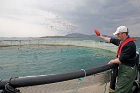
#MarineScience - A new marine research cluster is planned for Connemara incorporating the Údaras na Gaeltachta facility at Pairc na Mara currently under development in Cill Chiaráin, NUI Galway’s Carna Campus Laboratories, and an aquaculture site in Beirtreach Buí near Carna.
The Connemara cluster will form part of a national aquaculture research cluster which includes the Marine Institute facilities at Newport, Co Mayo, with the Beirtreach Buí site touted as “an important part of the State’s marine research infrastructure”.
In 2016, the Marine Institute secured EU Horizon 2020 and Science Foundation Ireland funding for a range of research projects that will be carried out in close collaboration with Marine Institute teams in Newport and Galway as well as researchers at the NUI Galway campus in Carna and the Udaras na Gaeltachta facility at Páirc na Mara.
These research projects will include studies on cleaner fish, which are used to control sea lice and other external parasites; animal welfare; and poly culture of shellfish, fin fish and seaweeds to enhance biodiversity and reduce environmental impacts.
The Marine Institute says it has committed funding to create three jobs to run and maintain the Beirtreach Buí aquaculture research site and provide support to marine research teams and projects.
The Beirtreach Buí site is expected to support a number of research projects in the coming years, including the development of integrated multi-trophic aquaculture, which provides the by-products, including waste, from one aquatic species as inputs (fertilizers, food) for another. This research will be in association with project partners in both Irish third-level institutions and partners from other EU states.
The site will also be used to support a major international project TAPAS, which has received €7 million from the EU under Horizon 2020.
The TAPAS project aims to develop cost-efficient management tools and practices for the European aquaculture sector to investigate the limits to fish farming activity in a location, social interactions, potential environmental impacts and any future risks.
The Marine Institute has applied to the Department of Agriculture, Food and the Marine to amend the licence for the aquaculture site at Beirtreach Buí from a commercial to a research license.
This application to amend the aquaculture licence at Beirtreach Buí will involve a reduction in the size of the site, a decrease in the number of licensed structures, from 48 structures to a maximum of 12 cages and 12 smaller structures made up of a combination of long lines and sentinel cages/passive sampling structures.
The amendment also includes a reduction in the level of fish stock at the site from the current level of 100 tonnes to a maximum of 50 tonnes. The amended license will allow for holding a range of fish, shellfish and seaweed species for research purposes. No commercial production will be licensed at the site.
The site was originally used for farming salmon in the 1980s and, in 2010, the aquaculture licence was amended in order to carry out culture trials on cod in collaboration with NUI Galway and Údaras na Gaeltachta.
In 2013 the site was taken over by the Marine Institute to focus on research work on cod and related studies, including research into natural alternatives for antifouling.
The new research licence application will go to public consultation this week.
#MCIB - Marine investigators have emphasised the dangers of drinking while at sea in the official report into the death of a lobster fisherman off Galway in April last year.
The body of Gerard Folan was recovered from the waters off St MacDara's Island, near Carna in Co Galway, on the morning of 24 April 2012 after he was reported missing the night before.
According to the report into the incident by the Marine Casualty Investigation Board (MCIB), Folan had set off in his currach from Dooeyher Pier in Carna around lunchtime on 23 April to check on lobster pots some 3nm away, off Deer Island - promising to contact his father on his return.
Folan was shortly after observed by another fisherman in the area, and was reportedly not wearing an oilskin nor a lifejacket.
Some hours later Folan's father went around the local piers but did not find his son. Later still, Folan's ex-wife contacted Clifden Coast Guard to report his disappearance and a search effort was mobilised.
Early the next morning, before the search resumed at first light, the fishing vessel Ocean Breeze sighted a drifting currach that was found to be Folan's. His body was later recovered off St MacDara's Island around 11am.
According to the MCIB report, it was not possible to determine how Folan became separated from his boat, though it was found that the currach's outboard engine had no kill cord attached, so it is probable the engine was running and the boat motored out of reach when he went overboard.
Although Folan was regarded as a strong swimmer, the post-mortem found elevated levels of alcohol in his bloodstream, which the MCIB report said would have hindered his attempts to swim back to his vessel.
Investigators also highlighted the "undue delay" in raising the alarm when Folan has failed to return earlier on the evening of 23 April.
The full report into the incident is available to download below.
Body Found in Search for Missing Currach Fisherman in Galway
#SEARCH AND RESCUE - A body was recovered yesterday during the search for a 43-year-old fisherman missing off the Galway coast, as RTÉ News reports.
The body was discovered near the shoreline of St Macdara’s island off Carna, some distance from the empty currach found early yesterday morning at Inis Mór in the Aran Islands to the south.
The missing man, named locally as Gerry Folan or Gearoid O'Cualáin, was last seen rowing a currach from the Mace Head area around 5pm on Monday evening.
As previously reported on Afloat.ie, a major air and sea search and rescue operation was launched, assisted by Irish Coast Guard helicopters and the Air Corps Casa patrol craft.
RTÉ News has more on the story HERE.


