Displaying items by tag: Marine Institute
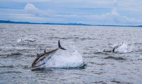
Fifteen angling vessels will soon be granted authorisation to participate in Tuna CHART (Catch and Release Tagging), a pilot Bluefin Tuna Data Collection Programme.
As previously reported for Afloat.ie by Lorna Siggins, the programme will see the 15 authorised vessels catch, tag and release Atlantic bluefin tuna for data collection purposes off the Irish coast.
These vessels, which are located in Cork, Clare, Galway, Sligo and Donegal, will support scientific work to increase knowledge of the behaviour and abundance of bluefin tuna in Irish waters — which currently do not host a sport or commercial fishery for the species.
The new programme, which has been developed by Inland Fisheries Ireland (IFI) and the Marine Institute in partnership with the Sea Fisheries Protection Authority (SFPA), the Department of Agriculture, Food and the Marine and the Department for Communications, Climate Action and Environment (DCCAE), will operate on a pilot basis this year.
Authorisations will be granted from mid-August until mid-October, and all skippers and trained crew have participated in training with guidance provided around fish handling, welfare, tagging and data recording.
Participants in the programme will catch, tag and release bluefin tuna while adhering to strict fish safety and handling procedures at all times.
Marine Minister Michael Creed has welcomed the initiative. “My department has been working on this project for two years at both EU and domestic levels and I am happy to announce the commencement of the project this month,” he said.
“This initiative will allow the Marine Institute and Inland Fisheries Ireland to collect valuable data on the migratory patterns of bluefin tuna in Irish waters in a tightly controlled environment.
“This project has been a wonderful example of co-operation between my department, DCCAE, SFPA, IFI and the Marine Institute and I am looking forward to the continued development of this relationship.”
Sean Canney, Minister with responsibility for inland fisheries, added: “The angling vessels which will be receiving authorisation from my department will contribute in a very tangible way to important data collection around Bluefin tuna as they migrate past the Irish coastline.
“The recreational fisheries sector is crucial in the delivery of this pilot programme and we look forward to working with all the State agencies involved and critically with the skippers and their crews who have received authorisations in providing valuable data for scientific purposes.”
The SFPA and IFI will undertake inspections and patrols around the coast to ensure this remains a strictly controlled fishery.
Anglers wishing to engage in this fishery must only do so on a sea angling vessel specifically authorised to participate in the pilot programme. Any person engaging in this fishery on any vessel which is not appropriately authorised will be in breach of the Sea-Fisheries and Maritime Jurisdiction (Bluefin Tuna) Regulations 2019 (SI No 265 of 2019).
New Shark Species Spotted In Irish Waters
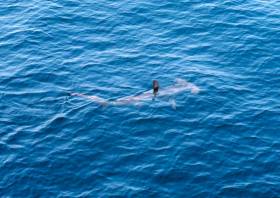
A shark species previously unrecorded in Irish waters has been sighted in the Celtic Sea.
A smooth hammerhead shark was reported on the edge of the continental shelf, south-west of Ireland, during a recent fisheries survey on the Marine Institute’s RV Celtic Explorer.
The sighting was made by experienced marine mammal observer John Power and bird observer Paul Connaughton during the Marine Institute’s Western European Shelf Pelagic Acoustic Survey (WESPAS).
“While scanning the ocean surface, we sighted a dorsal fin unlike anything we had encountered before,” said Power.
“It was quite different to the fins seen on basking sharks and blue sharks. After consulting available ID keys, we agreed that the shark must be a smooth hammerhead.”
The large, tall and slender dorsal fin of the smooth hammerhead shark distinguishes it from other shark species. The smooth hammerhead also has a single-notch in the centre of its rounded head and is up to four metres in length.
The species gives birth to live young and the pups are usually found in the shallow sandy waters near Florida, the Caribbean and West Africa. However, the species has been recorded as far north as England and Wales.
The smooth hammerhead was sighted during the WESPAS survey, which surveys the waters from France to Scotland and the West of Ireland each year.
Marine scientists collect acoustic and biological data on herring, boarfish and horse mackerel, which is used to provide an independent measure of these fish stocks in Irish waters. Scientists also monitor plankton, sea birds and marine mammals during this survey.
This is an exciting encounter, especially since a rare deep-water shark nursery was discovered by Irish scientists last year
Dr Paul Connolly, director of fisheries and ecosystems services at the Marine Institute, said: “Our Irish waters support a range of marine life and diverse ecosystems, including 35 known species of sharks.
“This is an exciting encounter, especially since a rare deep-water shark nursery, 200 miles west of Ireland, was discovered by Irish scientists last year using the Marine Institute's Remotely Operated Vehicle [ROV Holland 1].”
He added: “This sighting of a new shark species shows the importance of our fishery surveys to monitor our marine environment, and to observe changes in our oceans and marine ecosystems.
“Observing and understanding a changing ocean, is essential for protecting and managing our marine ecosystems for the future.”
The hammerhead shark poses little risk to humans, and there have been no known fatalities from hammerhead sharks anywhere in the world to date.
The species is listed as Vulnerable on the International Union for Conservation of Nature (IUCN) Red List of Threatened Species, and is being increasingly targeted for the shark fin trade as its large fins are highly valued.
Thirty-five species of sharks have been recorded in Irish waters, including the blue shark, porbeagle shark, lesser spotted dogfish and the second-largest shark in the world, the basking shark — a regular visitor inshore during the summer months.
Marine Institute Seeks New Chief Executive Officer
The Marine Institute, the State agency responsible for marine research, technology development and innovation in Ireland, is recruiting for a new chief executive to succeed Dr Peter Heffernan.
Reporting to the chair of the board of the Marine Institute, the CEO is responsible with the board for setting the strategic direction of the organisation in line with its mission, vision and values.
The institute seeks applications from high-calibre dynamic individuals with proven senior management experience and strong knowledge, experience and understanding of marine research, technology development and innovation.
The deadline for applications is 5pm GMT (6pm IST) on Tuesday 6 August. Mazars will be managing all aspects of the recruitment process on behalf of the Marine Institute. Further information on this role is available at Mazars.ie (Search Ref. MAR0119).
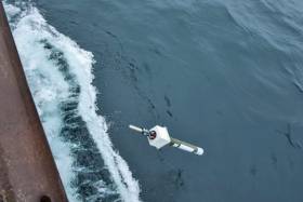
A German Argo float deployed off Greenland in 2014 travelled 3,500km across the Atlantic Ocean and was recovered off the coast of Co Cork in 2018.
The Marine Institute was able to trace the owner and help return the Argo float to the Federal, Maritime and Hydrographic Agency in Hamburg, Germany.
Argo floats are deployed across the world’s oceans and distribute real-time information on temperature and salinity from up to 2,000m below the ocean surface.
Argo float number 6902584 was deployed in 2014 from the RV Knorr between Greenland and Iceland, and provided regular measurements until March 2017. At this time the float was recorded in the Labrador Sea, off Newfoundland, Canada.
Data is transmitted via satellite every 10 days for the three-to-four years of an Argo float's lifespan. However, by July 2017, this float was drifting at the surface in the North Atlantic and only reporting its GPS location.
The Argo float was covered in marine growth; and clearing this debris revealed the float's unique identification number
Seven months later, in February 2018, the Marine Rescue Sub Centre (MRSC) in Valentia contacted the Marine Institute regarding an Argo float that had been recovered by a Union Hall lifeboat off the coast of West Cork.
Diarmuid Ó Conchubhair of the Marine Institute, manager of the Irish Argo programme and vice chair of the European-Argo Management Board, retrieved the Argo float from Co Cork.
And he thanked the Marine Rescue Sub Centre in Valentia for their efforts in recovering the float and keeping it in storage.
“The Argo float was covered in marine growth; and clearing this debris revealed the float's unique identification number,” he said.
“As a member of the European Argo Programme, the Marine Institute was able to contact national programme managers to trace the float to its owner, the Federal, Maritime and Hydrographic Agency in Hamburg.”
Earlier this year, the Marine Institute's RV Celtic Explorer transported the Argo float to Hamburg, where it is now a display and demonstration float at the Federal, Maritime and Hydrographic Agency.
Birgit Klein, manager of the German Argo Programme and chair of the European-Argo Management Board, expressed her thanks on behalf of the agency to the Marine Institute for collecting and returning the float.
She said: “The Argo float has recently been transformed into an exhibit — its metal hull has been replaced with a clear plastic cylinder to allow the public to view the float's internal mechanisms.
And Klein explained how this particular float came to malfunction.
“Analysis of the float data showed that the float experienced sub-zero water temperatures in the Labrador Sea. With such low surface temperatures, it was likely that sea ice was present and caused mechanical damage to the float.”
Such water temperatures were recorded by the Argo float in the Labrador Sea, off Newfoundland in Canada, during the winter seasons from December 2015 to May 2016 and again in December 2016 to April 2017.
There are currently 3,800 profiling floats in the world's oceans as part of the Argo Programme
Ó Conchubhair said: “It is not uncommon for research devices to travel from the Canadian coast to the west coast of Ireland. In early 2018, a research buoy was found on the shore at Connemara in Co Galway, and had drifted over 6,000km across the Beaufort Sea, Artic Ocean and Atlantic.
Argo floats are used collect measurements on temperature and salinity, what Ó Conchubhair says are two essential climate variables that help to describe the oceans’ physical and thermodynamic state.
“Through our involvement in the Euro-Argo Programme, the Marine Institute deploys three floats a year and works with international partners to observe and understand how our ocean is changing and also provide essential data for climate and oceanographic research,” he said.
There are currently 3,800 profiling floats in the world's oceans as part of the Argo Programme.
The Marine Institute’s participation in the programme allows Ireland to build national capacity in the ocean observation sphere and places Ireland at the centre of global efforts to model, project, mitigate and adapt to the potential impacts of climate change.
Click HERE for more information about Ireland’s involvement in the Argo programme, and track and view the data available from Irish Argo floats at digitalocean.ie
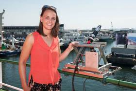
PhD student Catherine Jordan will bring her research on phytoplankton blooms to the third annual Soapbox Science even in Galway tomorrow afternoon (Saturday 29 June).
She will be among 12 female scientists standing on their soapboxes to talk about their groundbreaking research in the areas of science, technology, engineering, mathematics and medicine at the city’s Spanish Arch from noon to 3pm.
Jordan, a PhD candidate through the Marine Institute’s Cullen Fellowship Programme and NUI Galway, will discuss her research on using satellite technology to observe and identify phytoplankton blooms in North-East Atlantic waters.
“When conditions are right, phytoplankton appear in high numbers and produce green and dark red hues in the water and are known as ‘algal blooms’,” she explains.
“As these blooms can sometimes be visible from space, satellites provide a useful tool in monitoring the location and extent of these blooms.
“In most cases phytoplankton blooms are of benefit to the ecosystem, but a small proportion of phytoplankton species produce toxins which may affect other marine life.
“Satellites may be able to assist in providing early wide-scale warnings of the presence of algal blooms, by using ocean colour sensors. A lot of my research focuses on measuring optical properties of light by using different instruments and methods, as well as validating satellite measurements.”
Jordan recently joined the Marine Institute’s annual ocean climate research survey on the RV Celtic Explorer to collect plankton samples and hyperspectral radiometer data as part of her PhD research.
Speaking about the Soapbox Science even, Jordan said: “I am very passionate about my field of science and also promoting how women can work on marine research vessels and spend weeks at sea.
“It is very important to engage the public in learning about marine science in interactive ways in order to explain very complex matters. Soapbox Science is an excellent platform for promoting women in science and encouraging the public to discuss topics they may not have encountered before.”
Soapbox Science Galway began two years ago, and talks this year will cover a diverse range of topics such as enhancing farming using insects, the marvels of human milk, the internet as a force for good, and statistical thinking for real-life questions.
The event will also be held in Dublin and Cork, as well as in several countries around the world including the UK, US, Canada, Australia, Sweden, Germany, Brazil and South Africa.
For the full list of participants and more information about Soapbox Science visit soapboxscience.org
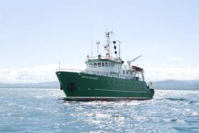
Scientists and students at NUI Galway’s Ryan Institute enjoyed a day trip on the Marine Institute’s research vessel RV Celtic Voyager on Friday (21 June) to take part in Ocean Sampling Day 2019.
Ocean Sampling Day is a simultaneous sampling campaign of the world’s oceans by scientists globally. It is organised by an EU consortium of marine research institutes, known as ASSEMBLE Plus, of which NUI Galway’s Ryan Institute is a partner.
Chief scientist Prof Louise Allcock, who is director of the Centre for Ocean Research and Exploration within the Ryan Institute, led a team of four experienced scientists and 11 marine science undergraduates who are in the first to third year of their studies.
Prof Allcock said: “We will sample and filter water from the ocean, and our filter papers, as well as those from other sites around the world, which will be sent to a molecular lab in a marine station in Greece where all the DNA on the filter papers will be sequenced to give an estimate of what bacterial and invertebrate species are present in the ocean.
“A healthy ocean has a wide variety of species, an unhealthy ocean less so — and hence we get an overview of our ocean health."
Sheena Fennell, one of the experienced scientists in the team who has spent extensive time at sea, explained the benefits to the undergraduate students joining the expedition.
“The students learn in their lectures all about the water column, the bacteria and invertebrates living therein, and the specialised gears that we use to sample, but this is an opportunity for them to get genuine hands-on experience while contributing to an international research project.”
The science team sampled directly above the SmartBay SubSea Cabled Observatory in Galway Bay.
Prof Allcock spoke of the importance of this site to the project: “The SmartBay Observatory provides subsea data all year round which means there is an enormous environmental dataset to complement our physical samples.
“Taking our samples from here also affords us the opportunity to highlight this impressive infrastructure to our European colleagues.”
The Marine Institute is also entertaining a group of third-level students as part of the 2019 Summer Bursary Programme.
Coming from a variety of disciplines across seven academic institutions, the students will gain experience in various fields of marine science including marine fisheries, aquaculture, communications, archiving, ecology, chemistry and catchment research in placements running between eight and 12 weeks.
“The work experience programme enables students from a wide variety of disciplines to further their knowledge and research in their particular area of interest,” said Helen McCormick, programme co-ordinator and senior laboratory analyst at the Marine Institute.
“It also offers students the opportunity to expand their professional networks, by meeting fellow students from other universities as well as work with experts in the their field and across the marine sector.
"Previous bursars have gained various positions within the Marine Institute at all grades up to and including director level.”
While many of the bursars will be based in the laboratories and offices at the Marine Institute’s headquarters in Oranmore, some students are also stationed at the catchment research facility in Newport, Co Mayo, where they will work with salmonids and eels, while others will be based in Castletownbere, Co Cork sampling fish and shellfish catches.
A number also took part in SeaFest 2019, Ireland’s national maritime festival, which took place from 7-9 June in Cork.
Ireland Collaborating With Cyprus On Centre Of Excellence For Marine & Maritime Research
A new joint initiative between Ireland and Cyprus for a Centre of Excellence for Marine and Maritime Research has been awarded a €15 million grant from the European Commission.
The funding under Horizon 2020: Widespread’s Coordination and Support Action call goes to the project titled CMMI MaRITeC-X, whose main objective is to establish a marine science and maritime research centre in Cyprus, the Cyprus Marine and Maritime Institute (CMMI), within the next seven years.
In this initiative, the Marine Institute and SmartBay Ireland is partnering with Cypriot government bodies (Municipality of Larnaka), private companies and organisations (GeoImaging Ltd, Maritime Institute of Eastern Mediterranean, SignalGenerix Ltd and Limassol Chamber of Commerce) as well as with the University of Southampton, UK.
The new institute to be formed in Cyprus will focus on research, technology development and innovation in several sectors critical for the Cypriot economy, such as maritime transport, marine ecosystems, offshore energy and other societal needs in the Eastern Mediterranean.
Currently in grant agreement preparation, the project is expected to kick off by end of the second quarter this year.
The Marine Institute says project complements the ambitions set out for Ireland in Harnessing Our Ocean Wealth relating to the development of our shipping and maritime industry by enabling Ireland to build expertise in these areas.
More broadly, the Harnessing Our Ocean Wealth strategy sets out clear targets in terms of turnover from the marine economy by 2020, and increasing the industry’s contribution to GDP to 2.4% a year by 2030.
The MaRITeC-X project will contribute to these objectives and is also consistent with Ireland’s Marine Research & Innovation Strategy. This strategy supports the implementation of Innovation 2020, Ireland’s national research and innovation strategy, which identifies the marine sector as one of eight areas of focus for social progress and the economy.
The Marine Institute’s contribution to the project (with a combined award of €2m) will be managed jointly by the Irish Maritime Development Office (IMDO) and SmartBay Ireland.
It’s expected that the project will allow Ireland to build national research and development capacity and to collaborate with institutions and organisations across Europe as it contributes to expertise in building marine and maritime clusters.
Marine Institute chief executive Peter Heffernan said: “We are delighted at news of the MaRITeC-X award. The award acknowledges the excellence and leadership that both the Marine Institute and SmartBay demonstrate in the European maritime landscape.
“We look forward to cooperating and collaborating with our Cypriot partners to the benefit of both innovation-led maritime economies.”
Garrett Murray, national director for Horizon 2020 at Enterprise Ireland, added: “Ireland continues to perform well under the programme and there is significant competitive funding available for Irish researchers and companies under Horizon 2020 with 40% of the budget remaining.
“EI and partner agencies are committed to supporting participation in H2020 to realise the Irish Government’s target of winning €1.2bn from the EU’s €70bn Horizon 2020 R&I budget.”
John Breslin, general manager of SmartBay Ireland said his company would be “reaching out to Irish businesses and research organisations who wish to collaborate with CMMI and its stakeholders, to help broker the development of joint projects and funding opportunities”.
Swedish Royals Pay Visit To Marine Institute Today
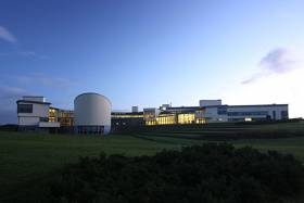
The Marine Institute will welcome King Carl XVI Gustaf and Queen Silvia of Sweden to its headquarters in Oranmore today, Friday 24 May.
The King and Queen of Sweden will be welcomed by Minister Seán Kyne, Government Chief Whip and Minister of State for the Irish Language, the Gaeltacht and the Islands, and greeted by senior officials from the Department of Agriculture, Food and the Marine.
King Carl XVI Gustaf has long been interested and active in the long-term health of our oceans and conservation of marine life, serving as chairman of the Swedish organisation of the World Wildlife Fund (WWF) since 1988.
The king is also guardian of the Baltic Salmon Fund, which promotes the sustainable management of wild salmon in the Baltic Sea and the rivers along the Baltic coast.
Minister Kyne said: “I look forward to welcoming King Carl XVI Gustaf and Queen Silvia of Sweden to the Marine Institute in Galway. The visit supports the shared interest between Ireland and Sweden to sustainably manage and develop our marine resource.
“I hope the visit encourages further collaboration between our two countries to observe and understand how our ocean is changing and respond to current and future patterns of change.”
Marine Institute scientists will speak to the Swedish royals about surveying and assessing fish stocks in Irish waters to assist in sustainably monitoring and developing Ireland’s fisheries resource.
The king and queen will also view a series of artworks produced as part of the EU-funded BlueFish Project, which aims to increase our knowledge and understanding of marine resources and the potential impacts of climate change in the Irish and Celtic Sea ecosystems. The delegation will also engage in discussions on marine renewable energy.
Marine Institute chief executive Dr Peter Heffernan said: “We look forward to meeting the King and Queen of Sweden and showcasing the work undertaken at the Institute, particularly in the area of ocean observation and fisheries assessment and monitoring.
“Providing scientific advice and services in these areas is one of the institute’s key roles, and essential to Ireland achieving a sustainable ocean economy, as well as protecting and managing our marine ecosystems.”
Chief executive Dr Peter Heffernan is representing the Marine Institute at European Maritime Day 2019 in Lisbon, Portugal this week.
Concluding today, Friday 17 May, European Maritime Day is one of the largest marine science and policy meetings of the year.
The 2019 programme focuses on blue entrepreneurship, research, innovation and investment to transform traditional maritime sectors and boost emerging technologies.
Dr Heffernan said the Marine Institute “plays a crucial role in supporting, co-ordinating and promoting marine research at a national and international level.
“By working alongside academic institutions in Ireland, and participating in and leading research partnerships, the institute is able to increase our knowledge of the ocean which will assist in the sustainable management and development of our marine resource.”
The Galway Statement, signed at the Marine Institute in 2013, provided the first step in forming the Atlantic Ocean Research Alliance (AORA) between the European Union, Canada and the United States of America.
AORA aims to promote a healthier Atlantic Ocean, find more sustainable ways to use its resources and increase people’s awareness and literacy surrounding the ocean.
“AORA is science diplomacy at work,” Dr Heffernan said. “Transatlantic cooperation has been instrumental to the success of AORA and creating a strong Atlantic community.
“Within five years, scientific research teams working together in the Atlantic have unearthed new discoveries and knowledge in the areas of seabed mapping, ocean observation, climate and polar research, and marine biotechnology.”
European Maritime Day encourages a ‘blue economy revolution’ to deliver economic growth in the maritime sector and expand employment opportunity.
The programme covers almost all aspects of marine science, technology and policy, and encourages participants to engage with partners from the EU community to exchange information.
The 2020 European Maritime Day annual meeting will be hosted by Cork City Council, which will mark the first time Ireland has hosted the event.
New Irish Research On Atlantic Salmon Scale Growth
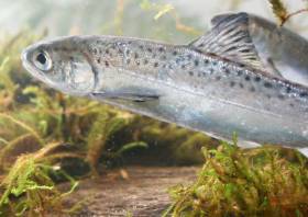
Research from Dr Katie Thomas of the Marine Institute has investigated the mechanisms for growth mark formation in scales of Atlantic salmon (Salmo salar Linnaeus) and the cause of variations in scale growth measurements.
Dr Thomas recently graduated with her PhD on her thesis, titled Scale Growth Analysis of Atlantic salmon (Salmo salar L) Unlocking Environmental Histories, from the Galway-Mayo Institute of Technology (GMIT) under the supervision of Dr Niall Ó Maoiléidigh, Marine Institute; Dr Deirdre Brophy, GMIT; and Tom Hansen, Institute of Marine Research Norway.
The PhD was funded by the Marine Institute, the Institute of Marine Research Norway and the Loughs Agency, Northern Ireland.
The Atlantic salmon is native to the temperate and sub-Arctic regions of the North Atlantic Ocean, utilising rivers for spawning and nursery and the marine environment for adult feeding, development and rapid growth.
Direct observation of the salmon’s life is challenging and costly, so scales are widely used to assess and monitor changes in growth.
“The entire life history of an individual fish is recorded on a scale which begins to form during the fry stage of the lifecycle,” Dr Thomas said.
“As the scale develops, it lays down concentric ridges or rings called circuli, which look similar to rings on a tree. The number of circuli on a scale and the distances between each circuli are measured to provide a history of individual and population growth histories.
“These changes over time can be used to infer the salmons use of the ecosystem, and indicate whether changes in growth are apparent over time and between populations.”
Scale measurements are taken from a specific body location as recommended by the International Council for Exploration of the Seas (ICES) to standardise scale analysis globally.
The first aim of Dr Thomas’ research was to compare wild Atlantic salmon growth measurements from different body areas and to establish a calculation or a conversion that could be applied to match the measurements from the standard sampling location.
“Because scales do not form at the same time, the size and shapes of scales can look very different to each other. The next part of my research was to take size and shape measurements from scales across the body and produce a calculation that determines where on the body a scale may have originated,” she added.
Overall salmon survival during the marine phase is strongly linked to the post-smolt growth period, which is the scale growth from when a young salmon migrates to sea up to the first winter at sea.
It is widely believed that circuli form on the scale every seven days during the summer and every 14 days during the winter and also the wider the distance between the circuli, the better overall growth is
As this had never been experimentally validated before, the next aim of the research was to undertake experiments in the Institute of Marine Research laboratory (Matre) in Norway.
Dr Thomas explained: “Results from the experiments showed that circuli formation rates are not constant but ranged between four to 18 days. In addition, the spacing between the circuli did not reflect growth rate suggesting that wide spacing between each circuli was not necessarily an indication of good growth.”
In the last stage of the research, scales from Atlantic salmon collected from three Irish rivers — Burrishoole, Moy and Shannon — between 1954 and 2008 were analysed to determine if marine growth had changed during that period.
The research showed that post-smolt scale growth declined over the decades corresponding to declines in return rates of Atlantic salmon, but the change in growth was not consistent between the different rivers.
This highlighted that the trends observed in one national index river may not be representative of change across all Irish populations, and that more than one index river should be used to investigate survival rates in our salmon populations.
The new knowledge generated from the PhD thesis supports more accurate interpretation of scale growth measurements, furthers our understanding of the factors affecting the survival of the wild Irish salmon and ultimately benefits the future management of this iconic species.
Dr Niall Ó Maoiléidigh of the Marine Institute said: “Dr Thomas’ research feeds directly into the institute’s long-term monitoring and stock assessment programme for Irish salmon stocks and the ongoing programme of research in the Burrishoole national index river initiated in the 1960s.
“These results are helping unravel the complicated links between climate change and factors which are causing persistent declines in salmon returns to rivers, not just in Ireland, but in countries on both sides of the Atlantic where salmon occur.”
Dr Thomas’ thesis is available on the Marine Institute’s Open Access Repository. A paper from this thesis titled ‘Experimental Investigation of the effects of temperature and feeding regime on scale growth in Atlantic salmon Salmo salar post-smolts’ was also recently published in the Journal of Fish Biology.
Dr Thomas’ current research is funded under Ireland’s DCF Pollack Programme, which is supported by the European Maritime and Fisheries Fund (EMFF).


