Displaying items by tag: Marine Institute
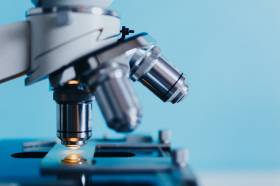
Researchers Talk Ocean Science At Marine Institute Symposium
The development of an app to help fishermen target areas with fish for which they have quota and avoid fish for which they don’t is just one of the innovations being developed by researchers at the Marine Institute.
The app, presented by Dr Julia Calderwood, is part of the EU-funded DiscardLess project, helping to ensure that the discarding of non-quota fish catches is phased out under the Common Fisheries Policy.
It is just one of many research projects that were presented at the Marine Institute’s Research Symposium on Thursday (24 October).
Seventy researchers from across the institute gathered to present their work, to brainstorm, and to identify ways to work better together.
Researchers presented short overviews and took questions on their work and on the future direction of research at the Marine Institute. There was also a poster session giving further overviews of research.
The institute says its initiative to try to integrate better research across areas such as fisheries science, climate change, oceanography, fish health, seafood safety and ocean chemistry is a critical goal of the its strategy, Building Ocean Knowledge, Delivering Ocean Services.
The Research Symposium featured presentations from principal investigators to PhD students on research projects that support important policy areas for Government. The outputs from a project tracking the migration patterns of bluefin tuna, for example, support key policy areas for the Department of Agriculture, Food & the Marine.
The fate, impact and new approaches to persistent pollutants in the marine environment were also addressed and the outputs of this work support key policy areas for the Department of Housing, Planning and Local Government.
Research that supports the seafood sector was addressed with food safety issues around marine biotoxins being presented. Research into the genetic basis for natural starvation in wild Atlantic salmon was presented which will, through manipulation of diet and temperature, help to reduce the time taken for farmed fish to reach a stage of maturity where they can go out to sea cages, thus reducing grow-out time and costs for the salmon farmer.
Research and innovation is a key component of the Marine Institute’s Strategic Plan 2018-2022, and is aligned to the provision of scientific advice and services.
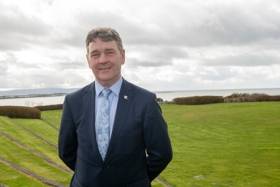
New Marine Institute chief executive Dr Paul Connolly explained the thinking behind the Research Symposium: “The Marine Institute provides essential scientific evidence and advice to Government and to stakeholders to ensure that we are sustainably managing our marine resources and our extensive maritime territory, which is about 10 times the size of our landmass.
“Our research is central to providing the knowledge we need to inform policy and to address challenges such as climate change and ocean pollution while helping to build sustainable maritime sectors such as aquaculture, ocean renewable energy and marine and coastal tourism.”
The Marine Institute Research Symposium is intended to be an annual event, forming part of the efforts being made to deliver knowledge and services that are safeguarding our ocean resources and supporting a healthy and sustainable ocean economy in Ireland.
Workshop Hears Latest Research On Shellfish Safety
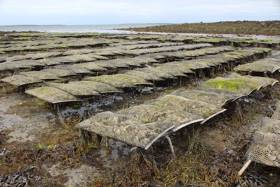
More than 90 shellfish producers and processors, scientists, agencies and stakeholders attended the 11th Shellfish Safety Workshop earlier this month to discuss the latest advances in the field in Ireland.
The workshop, which took place on Tuesday 8 October in the Radisson Blu Hotel Athlone, was hosted by the Marine Institute and co-sponsors Food Safety Authority of Ireland, Sea Fisheries Protection Authority and Bord Iascaigh Mhara.
The event offered an opportunity to exchange information on the latest research and information on the cause and control of shellfish products harvested and farmed around Ireland's coast.
Speakers included Dr Conor Graham, of GMIT Marine and the Freshwater Research Centre, on the development of the world’s first scientific-based shellfish traceability tool, as previously reported on Afloat.ie.
Other speakers included Dr Monika Dhanji Rapkova, of the Centre for Environment, Fisheries and Aquaculture Science, on the learnings on regulated and emerging biotoxins in British shellfish.
Dr Eileen Bresnan (Marine Scotland Science) presented a talk on the regional distribution of harmful algal events in North Atlantic Area. Dave Clarke of the Marine Institute also talked about the insights and perspectives on monitoring algal and biotoxin events in Irish coastal waters from the past 20 years.
Micheál O'Mahony of the Sea Fisheries Protection Authority presented on the recently published European baseline survey of norovirus in oysters, while Dr Sinéad Keaveney (Marine Institute) discussed the survey in the Irish context.
There were also a series of flash presentations from representatives of the Marine Institute, Bord Iascaigh Mhara, Sea Fisheries Protection Authority, Food Safety Authority of Ireland, Dublin City University, Sligo Institute of Technology and Health Services Executive.
The proceedings of the workshop are currently being compiled for publication and in the coming weeks will be available for download from the Marine Institute’s Open Access Repository.
An ‘Irish ocean observing system’ is among six research projects to receive €25 million in funding through the Science Foundation Ireland (SFI) Research Infrastructure Programme.
Innovation Minister Heather Humphreys yesterday (21 October) announced the investment as part of Future Jobs Ireland that will be distributed among the six infrastructure projects “in areas of strategic priority across a variety of disciplines”.
Mr Michael Gillooly of the Marine Institute is lead on the EirOOS Irish Ocean Observing System, a component of the European Ocean Observing System (EOOS) that aims to further scientific and technical research capacity in key areas such as sea level science, ocean circulation and carbon sequestration, allowing us to better understand the connection between Ireland and the Atlantic.
Announcing the awards, Minister Humphreys said: “The quality of research being undertaken in Ireland today is testament to our world-class research community. This talent combined with the support provided through programmes like this one maintains our reputation as a great place to do business and work.
“The successful projects are at the cutting edge of innovation and are helping us to achieve our goal of preparing now for tomorrow's world.”
The SFI Research Infrastructure Programme aims to ensure Irish researchers have the capacity to apply for international funding opportunities, including Horizon 2020 funding calls.
Additionally, the programme eases inter-institutional sharing of national research infrastructure, especially for institutes of technology, as well as effective collaborations with industry.
Welcoming the investment in EirOOS, new Marine Institute chief executive Dr Paul Connolly said: “Sustainably managing our oceans and understanding the impacts of ocean and climate change, requires increased observations on and within the ocean.
“These observations underpin research and advice to support policy makers in sustainably managing our oceans and also in developing adaptation and mitigation plans for climate change impacts.
“The investment in the EirOOS infrastructures will enable enhanced ocean observation and underpin forecasting and modelling in the marine area.”
Annual Irish Groundfish Survey Commences End Of This Month
The annual Irish Groundfish Survey (IGFS 2019) will take place off the North, West and South Coasts for six weeks from 31 October.
Carried out by the Marine Institute, the IGFS is a demersal trawl survey consisting of around 170 fishing hauls, each of of 30 minutes’ duration, in ICES areas VIa, VIIb, VIIg and VIIj.
As part of the requirements for the 2019 survey, fishing will take place within a 2-nautical-mile radius of indicated positions.
The survey will be conducted by the RV Celtic Explorer (callsign EIGB) which will display appropriate lights and signals.
The vessel will be towing a high headline GOV 36/47 demersal trawl during fishing operations.
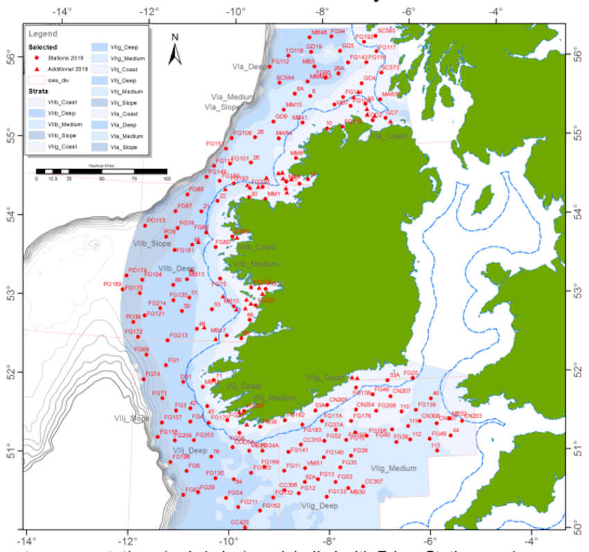
Co-ordinates and approximate locations of these hauls are included in Marine Notice No 47 of 2019, a PDF of which is available to read or download HERE.
The Marine Institute requests that commercial fishing and other marine operators keep a 2nm area around the tow mid-points clear of any gear or apparatus during the survey period between Thursday 31 October and Friday 14 December.
This survey follows the annual Irish Anglerfish and Megrim Survey which was conducted off the West South West and South Coasts in March.
Peter Heffernan Says Farewell to the Marine Institute
Dr Heffernan has served as the CEO of the Marine Institute since 1993 and has held a highly successful role in building and leading the organisation. The semi-state agency has grown from a staff of one to 230, which now incorporates the Institute’s headquarters in Co Galway, the Newport Research Facility in Co Mayo and the Irish Maritime Development Office (IMDO) in Dublin.
Chairman of the Marine Institute Dr John Killeen said, “As CEO, Dr Heffernan has overseen tremendous growth. He has played a fundamental role in developing Ireland’s ocean research capacity, increasing collaboration in marine research and innovation in Europe, as well as driving sustainable development across a range of maritime sectors. Dr Heffernan leaves a lasting-legacy and has set the Institute on course to become a global leader in ocean knowledge. On behalf of the Board and Marine Institute staff, I thank Dr Heffernan for his dedication, strategic direction and leadership as CEO and wish him all the best as he begins a new voyage.”
As CEO of the Institute, Dr Heffernan has overseen the arrival of Ireland’s two purpose-built marine research vessels, the RV Celtic Voyager in 1997 and the RV Celtic Explorer in 2003. The RV Celtic Voyager has provided a platform for scientists to undertake essential fisheries research, environmental monitoring, seabed mapping, oceanographic work, data buoy maintenance and student training. The RV Celtic Explorer has played a vital role in Ireland’s fisheries research, placing Ireland in a much stronger position to propose effective conservation measures for fish stocks and support the sustainability of the Irish fishing industry. A new state-of-the-art marine research vessel is also scheduled for completion in 2022, which will mark a major milestone in the Marine Institute’s effort to provide world-class marine scientific advice and services.
In 2009, Dr Peter Heffernan instigated the development of the Inter-Department Marine Coordination Group (MCG). Chaired by the Minister for Agriculture, Food and Marine, the group brought together representatives of departments with an involvement in marine and maritime issues to coordinate inter-departmental action. The MCG produced Ireland’s first integrated marine plan for Ireland Harnessing Our Ocean Wealth in 2012 which set out two targets - increase the value of Ireland’s ocean wealth to 2.4% of GDP by 2030 and double the turnover from our ocean economy (from €3.2 billion) to exceed €6.4 billion by 2020. In 2018, Ireland’s ocean economy is estimated to have a turnover of €6.2 billion and GVA estimated at €4.2 billion equivalent to 2% of GDP.
In 2013, Dr Heffernan acted as an inspiration and Irish EU Presidency ambassador for the creation of the Atlantic Ocean Research Alliance (AORA) with the signing of the Galway Statement on Atlantic Ocean Cooperation between Canada, the European Union and the United States of America. Six years on and AORA has been recognised as an outstanding success story in the Atlantic area and an exemplar of international science diplomacy. To date, AORA has achieved an investment from Horizon 2020 EU funding of more than €140 million to support research in the Atlantic Ocean.
Ireland is now considered a world leader in the field of seabed mapping through the expertise of the Geological Survey Ireland and the Marine Institute. The Irish National Seabed Survey (INSS), which began in 1999 remains one of the largest seabed mapping projects ever undertaken in the world. Now known as the INFOMAR programme and scheduled for completion in 2026, Ireland will become the first nation in the world to have comprehensively mapped its entire seabed territory.
Research and Innovation are central to the role and mission of the Marine Institute. A Marine Knowledge, Research and Innovation Strategy for Ireland, ‘Sea Change’ was prepared by the Marine Institute and launched in 2007. A new National Marine Research and Innovation Strategy 2021 was also prepared by the Marine Institute in 2017, to help ensure Ireland maintains its position at the forefront of marine research in Europe.
The Marine Institute has achieved an outstanding success rate of over 40% in funding bids to the European Union’s Horizon 2020 programme. The total funding approved to date under this programme has now surpassed the €8m target, 18 months ahead of schedule. The work of the Marine Institute has seen significant collaborations with industry and other research centres and universities in Ireland, Europe and international stakeholders, strengthening Ireland’s ability in providing a foundation for applied research and innovation.
Dr Heffernan was recently selected as a member of the European Commission’s Mission Board for Healthy Oceans, Seas, Coastal and Inland Waters, one of five major research missions of Horizon Europe, the EU Research and Innovation programme (2021 – 2027). Dr Heffernan will be one of 15 experts on the Mission Board which will identify the first possible specific missions on healthy oceans by the end of 2019.
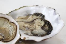
Studies carried out by a research team led by Galway-Mayo Institute of Technology (GMIT) have resulted in the development of the world's first scientific-based shellfish traceability tool.
This unique tool used ‘trace elemental fingerprinting’ of shellfish soft tissues and shells to identify the harvest location of blue mussels and king scallops with a 100% success rate — including mussels reared from two sites located just 6km apart within the one bay.
The technique used not only correctly identified the site of harvest of scallops, but was also able to distinguish between harvesting events just six weeks apart, both with 100% success.
The Marine Institute provided scientific advice and input into the initial stages of the research project, as well as providing samples of mussels and scallops for the studies led by Dr Conor Graham of the GMIT Marine and Freshwater Research Centre in collaboration with Dr Liam Morrison of Earth and Ocean Sciences and the Ryan Institute, NUI Galway.
The research was also conducted in association with the Food Safety Authority of Ireland, European Food Safety Authority and University College Dublin.
Lead scientist Dr Graham said: “In recent years consumers have become more food-conscious, seeking traceability of produce, and while such tools exist for agriculture, until now no scientifically based system existed to trace both farmed and wild shellfish produce to their source.
“The aquaculture of shellfish such as mussels and oysters and the wild fisheries for scallops, razorfish and clams is a multi-million industry in Ireland supporting thousands of jobs in rural maritime communities around our coasts. This research aimed to create the world’s first bivalve shellfish scientifically based traceability tool for Irish produce to promote this ecologically sustainable food.”
Trace elemental fingerprinting is somewhat similar to genetic analyses, the Marine Institute explains, except that instead of identifying the variation in a number of genes to create a unique genetic identifier, it analyses how large numbers of trace elements contained naturally within the flesh and shells of shellfish vary uniquely according to growing sites.
Although the shells of mussels and scallops are composed primarily of calcium carbonate, other elements are incorporated into their shells at relatively low levels as they grow, which is determined by the bioavailable concentrations of these elements in the surrounding water column in which the shellfish live.
The research was recently published in two scientific papers (on king scallops and blue mussels, respectively) in international peer-reviewed journal Science of the Total Environment.
Details will also be presented by Dr Graham at the Marine Institute’s 11th Shellfish Safety Workshop next Tuesday 8 October at the Radisson Blu Hotel in Athlone. The event will include presentations from representatives from a variety of state agencies, academic and research institutions and the shellfish industry.
The Marine Institute is the national reference laboratory in Ireland for the monitoring of marine biotoxins and microbiological/viral contamination of bivalve shellfish, and provides this information to the competent authorities under legislative and statutory requirements.
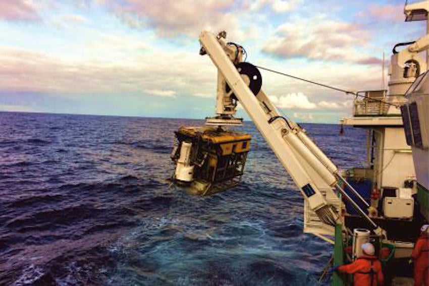
Third Expedition Completes ROV-ing Of Ireland’s Offshore Reef Habitats
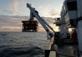
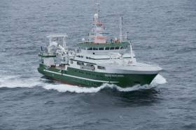
An Irish-led, international team of marine scientists on board the RV Celtic Explorer recently completed the third and final leg of an extensive offshore reef study using the Marine Institute’s remote operated vehicle (ROV) Holland 1.
The 21-day expedition investigating sensitive deep-sea habitats at the outer extent of the continental shelf off the southwest of Ireland was part of the SeaRover (Sensitive Ecosystem Assessment and ROV Exploration of Reef) project.
During their time at sea, the survey team mapped 154 separate locations within Ireland's marine territory, in what the Marine Institute describes as one of the most significant deep water benthic habitat assessments undertaken in this country.
The data and findings will contribute to good fisheries practice and the sustainable management of Ireland's marine biodiversity, the institute adds.
The survey used the ROV Holland 1 to capture high-definition footage of reef habitats up to 3000 metres deep, and to recover biological and sediment samples from 52 locations along the continental margin.
“Sensitive reef habitats form fragile ecosystems and attract a variety of marine species, such as sea pens, sponges, fish and crustaceans,” said survey chief scientist Yvonne Leahy, of the National Parks and Wildlife Service (NPWS).
“Surveying these habitats enables us to better understand Ireland’s deep sea territory so that we can protect and monitor our marine biodiversity and sustainably manage Ireland's marine resources effectively.”
Scientists from NUI Galway and University of Plymouth also joined the expedition to gather a range of biological samples to enable further research into population genetics studies, ecological modelling, and the harvesting of sponges for potential novel compounds for use in bio-medical applications.
Sediment samples will also be utilised for microplastics studies by NUI Galway and Galway-Mayo Institute of Technology (GMIT).
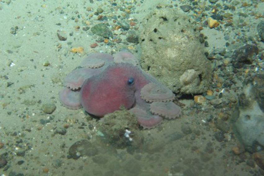 An octopus 1,000 metres below the surface | Photo: Marine Institute
The three SeaRover surveys between since 2017 have involved a combined 63 days at sea, recorded 332 hours of high-definition video from the seafloor — almost 14 days of footage — and have undertaken detailed studies of 350km of seabed along a shelf extent of nearly 2,500km.
The surveys have explored 154 different locations along Ireland’s continental margin, including the Rockall and Porcupine Banks, the Goban Spur and the Whittard Canyon.
The HD camera picks up fine detail of deep-water coral species. The first SeaRover survey in 2017 included the discovery of the deepest known occurrence of the cold-water coral Solenosmilia variabilis, forming reefs in Irish waters at depths of 1,600m.
In 2018 the team discovered a rare shark nursery, 200 miles west of Ireland. A large number of egg cases were filmed on the seafloor at depths reaching 750m, and a large school of blackmouth catshark (Galeus melastomus) were present at the site. There were also numerous recordings of different coral species observed in Irish waters for the first time.
“After three years, the survey team has created an extensive data set which represents one of the most comprehensive assessments of Ireland's marine biodiversity,” said Leonie O'Dowd, Marine Institute section manager and European Maritime and Fisheries Fund (EMFF) programme co-ordinator.
“The success of these surveys is thanks to the coordination and collaboration across many organisations and government departments, and will benefit national policy development as well as researchers and scientists exploring our marine territory in the future.”
Thomas Furey, the Marine Institute’s joint INFOMAR programme manager, added: “It is fantastic to see the underlying INFOMAR seabed mapping data being used to strategically identify and target such vulnerable marine ecosystems for detailed studies in support of future marine management plans.
“In funding INFOMAR, the Department of Communications, Climate Action and Environment are supporting key evidence based investigations of our ever changing marine environment.”
The three-year SeaRover project was commissioned and jointly funded by the Irish Government and the EU’s European Maritime and Fisheries Fund (EMFF).
The cross-government initiative was supported by the Department of Agriculture, Food and Marine, Department of Culture, Heritage and Gaeltacht, and Department of Communications, Climate Action and Environment as part of the Marine Institute’s implementation of the EMFF Marine Biodiversity scheme.
Survey operations were led by the Marine Institute, INFOMAR and NPWS, accompanied by scientists from NUI Galway and the Marine Biology and Ecology Research Centre at the University of Plymouth, and supported by scientists in Geological Survey Ireland and the Norwegian Marine Institute.
Marine Tech Firm Xocean Eyes Expansion To North America & Beyond
Louth-based marine technology firm Xocean is following its recent funding boost with plans to expand into North America and eventually Asia, according to business news site Fora.
The company specialises in innovative robotics, particularly unmanned vehicles, and IoT technology to monitor and collect data at sea.
Earlier this year it was awarded €199,739 in funding over two years via the Marine Institute to transform marine monitoring and data collection, as previously reported on Afloat.ie.
In addition the Greenore-based business raised half a million euro from Chris Huskilson, former CEO of Canadian energy company Emera and now chairman of Xocean.
While its focus until now has been on northern Europe, with clients including the UK’s Maritime and Coastguard Agency, Xocean confirms it is in discussions to deliver its first projects in the US and Canada within the next six months.
Fora has much more on the story HERE.
Marine Institute chief executive Dr Peter Heffernan has been selected as a member of the European Commission’s Mission Board for Healthy Oceans, Seas, Coastal and Inland Waters.
He is one of two Irish appointees to the Mission Boards of Horizon Europe, the EU Research and Innovation programme (2021 – 2027).
And he joins 14 other experts on his Mission Board which will identify the first possible specific missions on healthy oceans by the end of 2019.
Dr Heffernan has served as CEO of the Marine Institute since its formation in 1993, and will retire from this role in October this year. The Marine Institute is currently recruiting for his successor, with the deadline for applications at close of business next Tuesday 6 August.
Welcoming the announcement of Dr Heffernan’s new appointment, Marine Institute chairman Dr John Killeen said he “has played a fundamental role in developing Ireland’s ocean research capacity, and for driving collaboration in marine research and innovation in Europe and internationally.
“I congratulate Peter on his appointment, which reflects his strong standing in the European research community.”
Over 2,100 individuals from across the EU and beyond applied to become a member of a Mission Board. Dr Heffernan previously served on the EU’s Research and Innovation Area Board (ERIAB) from 2012 to 2016.
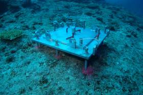
Marine scientists from University College Cork have discovered plastic at the bottom of a deep submarine canyon while investigating cold-water coral habitats.
UCC’s Marine Geology Research Group has been investigating cold-water coral habitats in the Porcupine Bank Canyon, some 320km due west of Dingle, on a research expedition led by UCC’s Dr Aaron Lim on board the Marine Institute’s RV Celtic Explorer.
The team had recovered eight novel monitoring stations, called ‘landers’, worth €450,000 and deployed between 700m and 2500m water depth by the Marine Institute’s Remotely Operated Vehicle (ROV) Holland 1 earlier this summer.
The monitoring stations record the speed, temperatures and direction of the currents around these habitats as well as trapping samples of the food, sediments and microplastic being deposited around the corals, to understand conditions and how the corals are coping with changing oceans.
The researchers found plastic in the bottom of one canyon at 2,125m water depth — as deep as ten Eiffel Towers stacked on top of one another.
The reach of human plastic waste is now confirmed as this deep, even 320km offshore.
“It’s always sad to see plastic rubbish in these otherwise pristine habitats. It’s quite incredible that our plastic waste can get this far out and so deep in the oceans,” said Professor Andy Wheeler of UCC, who has pioneered research on cold-water coral mounds offshore of Ireland over the past 20 years.
“I don’t think people think about this when that dump their rubbish. We’re also trying to see if microplastics are being fed to the corals from above. We’ve just got the samples; let’s hope we're wrong.”
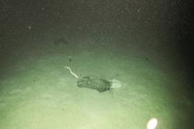
 ROV Holland 1 recovering one of the monitoring stations | Photo: UCC
The Porcupine Bank Canyon is teeming with a whole range of cold-water coral habitats, just on Ireland’s doorstep, says Dr Lim.
“The environment is much more dynamic than we thought, with two of the monitoring stations knocked over by the currents; food supply for the coral is variable but the corals are doing okay.
“Some of these habitats have existed for millions of years and have grown so large they resemble hills made of coral, called coral mounds.
“This is the first time eight of these monitoring stations have been deployed and collected using the ROV Holland 1. It will provide scientists with an insight into the processes affecting these cold-water coral habitats, food sources and the impact of microplastics.”
Dr Lim said Ireland’s cold-water coral reefs are found in the cold, dark ocean at water depths of 600m to 1,000m along our continental margin.
“Not only is this expedition vital for understanding these habitats and our impact upon them, it also acts as a baseline to start monitoring how our deep-water habitats here are changing,” he added.
The team has a research agenda which will see them return to the canyon and other habitats alike for a number of years, to monitor the changes in the environment around these habitats. The monitoring stations will be brought back to UCC for detailed analyses.
This research survey is carried out with the support of the Marine Institute, funded under the Marine Research Programme 2014-2020 by the Government to support and promote the Atlantic Ocean Research Alliance, which facilitates common research and knowledge exchange for us to provide healthy, resilient oceans for our future generations.
The survey has also received funding from Science Foundation Ireland, Geological Survey Ireland and UCC.


