Menu

Ireland's sailing, boating & maritime magazine

Dublin Bay Boating News and Information

Displaying items by tag: North East Coast

4th December 2009

Dundalk Port Company

Dundalk Port Company

The Port is owned by Dundalk Port Company and is located on the North East coast of Ireland. It is ideally located as a gateway between Northern Ireland and the Republic of Ireland.

The Port, situated almost exactly halfway between the cities of Belfast and Dublin, enjoys major road connections to both cities via the N1 national primary road. This enables easy transportation of goods to both cities from Dundalk in about an hour.

The port offers a range of services including general cargo handling, pilotage, customs, etc.

Pilotage – Dundalk Port Company also provide a compulsory pilotage service which leads ships up the 8km stretch from the open sea. The Port is serve by a main pilot boat and an auxiliary boat.

Facilities – Ships of up to 3,500 dwt and 106m in length can be handled. Five 30-tonne crawler cranes at minimum radius are capable of discharging up to 160 tonnes per hour each. Ships of upto 3000 tons can be discharged in 12 hours.
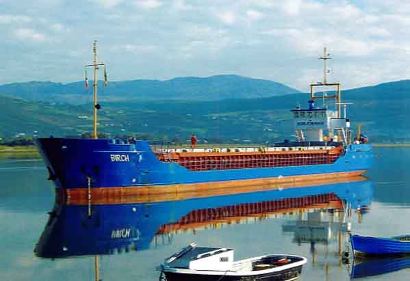
ship1.jpg 

About Dundalk Port

Dundalk Port has a long tradition of shipbuilding and registration.

The Port also has a long history of trading in different products with traffic through the port having consisted of gypsum, perlite, sand, peat, salt, scrap, pit props, cattle, fertilizers, machinery, paper, wood and general cargo to name a few.

The First vessel recorded as trading to Dundalk was the Trinitic which sailed from Liverpool to Dundalk in March, 1580. The year 1646 saw a grant of  'perfect freedom of trade' to Dundalk.

The harbour was naturally shallow and was left to its own devices until, in 1721 Lord Limerick, who at that time was high sheriff of Co. Louth, made a deal with the corporation to construct a harbour.

In 1740 he set about the construction of a quay in the form of a pier, extending into the river upstream from the present harbour. In 1767 the Irish Parliament voted £2000 and £400 yearly to improve the harbour. This sum was paid for 8 years and amounted in all to £5,200.

Early in the year 1800 Lord Roden appointed a harbour master and claimed authority over the harbour works. In 1803 the new Custom House was built and there was a military guard placed where goods were stored at the quays.

In 1840 an Act 'for regulating, preserving, improving and maintaining the river, port and harbour of Dundalk"'was passed. Under this act, 27 commissioners were appointed who had certain shipping and property qualifications.

In August 1848 a contract was signed and accepted for the construction of the pile lighthouse. The lighthouse was completed in June 1855. Soon after, in November 1860, a fog signal bell came into operation.

In 1967 work began to convert the lighthouse to electric and unwatched. The new light was exhibited on 17th December, 1968 with an increased intensity to 187,000 candle power in the white sectors. The fog horn signal was established on 25th June 1969.

In 1968 the B&I ended its Dundalk–Newry–Liverpool service. The last four ships on this service were MV Dundalk, MV Inniscarra, MV Wicklow  and MV Kilkenny. The B&I compound was sold to the McGinnty family who used the premises for grain warehousing. This premises is now in the hands of Lockingtons Shipping, a subsidiary of Dundalk Port Company.

Towards the latter end of the 20th century, extensive work was carried out on the quays to repair, maintain and extend them to their current status. 220 metres of the current 400 metres of quay wall were just recently constructed in 1992.

In response to the steady rise in port traffic, 2 separate quays were linked with a new 25 metre stretch to form a single long, linear quay.

In 2002 Dundalk Port became a semi state limited company owned by the state. Captain Frank Allen is Chief Executive of Dundalk Port Company.

For a location map, please click here

Dundalk Port Company, 40 Quay Street, Dundalk, Co. Louth. Tel: 00353 (0)42 9334096 • Mobile: 00353 (0)87 2566594 • Fax: 00353 (0)42 9335481  • Email: [email protected]

Published in Irish Ports

Dublin Bay

Dublin Bay on the east coast of Ireland stretches over seven kilometres, from Howth Head on its northern tip to Dalkey Island in the south. It's a place most Dubliners simply take for granted, and one of the capital's least visited places. But there's more going on out there than you'd imagine.

The biggest boating centre is at Dun Laoghaire Harbour on the Bay's south shore that is home to over 1,500 pleasure craft, four waterfront yacht clubs and Ireland's largest marina.

The bay is rather shallow with many sandbanks and rocky outcrops, and was notorious in the past for shipwrecks, especially when the wind was from the east. Until modern times, many ships and their passengers were lost along the treacherous coastline from Howth to Dun Laoghaire, less than a kilometre from shore.

The Bay is a C-shaped inlet of the Irish Sea and is about 10 kilometres wide along its north-south base, and 7 km in length to its apex at the centre of the city of Dublin; stretching from Howth Head in the north to Dalkey Point in the south. North Bull Island is situated in the northwest part of the bay, where one of two major inshore sandbanks lie, and features a 5 km long sandy beach, Dollymount Strand, fronting an internationally recognised wildfowl reserve. Many of the rivers of Dublin reach the Irish Sea at Dublin Bay: the River Liffey, with the River Dodder flow received less than 1 km inland, River Tolka, and various smaller rivers and streams.

Dublin Bay FAQs

There are approximately ten beaches and bathing spots around Dublin Bay: Dollymount Strand; Forty Foot Bathing Place; Half Moon bathing spot; Merrion Strand; Bull Wall; Sandycove Beach; Sandymount Strand; Seapoint; Shelley Banks; Sutton, Burrow Beach

There are slipways on the north side of Dublin Bay at Clontarf, Sutton and on the southside at Dun Laoghaire Harbour, and in Dalkey at Coliemore and Bulloch Harbours.

Dublin Bay is administered by a number of Government Departments, three local authorities and several statutory agencies. Dublin Port Company is in charge of navigation on the Bay.

Dublin Bay is approximately 70 sq kilometres or 7,000 hectares. The Bay is about 10 kilometres wide along its north-south base, and seven km in length east-west to its peak at the centre of the city of Dublin; stretching from Howth Head in the north to Dalkey Point in the south.

Dun Laoghaire Harbour on the southside of the Bay has an East and West Pier, each one kilometre long; this is one of the largest human-made harbours in the world. There also piers or walls at the entrance to the River Liffey at Dublin city known as the Great North and South Walls. Other harbours on the Bay include Bulloch Harbour and Coliemore Harbours both at Dalkey.

There are two marinas on Dublin Bay. Ireland's largest marina with over 800 berths is on the southern shore at Dun Laoghaire Harbour. The other is at Poolbeg Yacht and Boat Club on the River Liffey close to Dublin City.

Car and passenger Ferries operate from Dublin Port to the UK, Isle of Man and France. A passenger ferry operates from Dun Laoghaire Harbour to Howth as well as providing tourist voyages around the bay.

Dublin Bay has two Islands. Bull Island at Clontarf and Dalkey Island on the southern shore of the Bay.

The River Liffey flows through Dublin city and into the Bay. Its tributaries include the River Dodder, the River Poddle and the River Camac.

Dollymount, Burrow and Seapoint beaches

Approximately 1,500 boats from small dinghies to motorboats to ocean-going yachts. The vast majority, over 1,000, are moored at Dun Laoghaire Harbour which is Ireland's boating capital.

In 1981, UNESCO recognised the importance of Dublin Bay by designating North Bull Island as a Biosphere because of its rare and internationally important habitats and species of wildlife. To support sustainable development, UNESCO’s concept of a Biosphere has evolved to include not just areas of ecological value but also the areas around them and the communities that live and work within these areas. There have since been additional international and national designations, covering much of Dublin Bay, to ensure the protection of its water quality and biodiversity. To fulfil these broader management aims for the ecosystem, the Biosphere was expanded in 2015. The Biosphere now covers Dublin Bay, reflecting its significant environmental, economic, cultural and tourism importance, and extends to over 300km² to include the bay, the shore and nearby residential areas.

On the Southside at Dun Laoghaire, there is the National Yacht Club, Royal St. George Yacht Club, Royal Irish Yacht Club and Dun Laoghaire Motor Yacht Club as well as Dublin Bay Sailing Club. In the city centre, there is Poolbeg Yacht and Boat Club. On the Northside of Dublin, there is Clontarf Yacht and Boat Club and Sutton Dinghy Club. While not on Dublin Bay, Howth Yacht Club is the major north Dublin Sailing centre.

© Afloat 2020