Displaying items by tag: Silt
One of the country’s leading marinas will become unusable for keelboats unless urgent action is taken to address increasing silting in the harbour area writes David Forsythe in West Cork
Kinsale-based Fine Gael councillor Kevin Murphy told the recent meeting of Cork County Council’s Western Division that the issue was among the most serious he had ever had to bring to the attention of the council.
“The story is that Kinsale Harbour itself has severe silting at the yacht marina and around pier head itself. A substantial number of the keelboats are bottoming out now. This is a very serious issue and a very expensive one to sort out because there is a substantial dredging to be done,” he said.
Matthias Hellstern, Commodore of the Kinsale Yacht Club said that the issue had become much more serious in the last few years and the rate of silting in Kinsale Harbour seemed to be increasing.
“During Covid there was obviously a lot less activity at the marina and in the harbour in general because of the restrictions. It has been happening over a number of years but seems to be getting much worse now. It is something that we really need to address urgently,” he said.
 Matthias Hellstern, Commodore of the Kinsale Yacht Club Photo: Bob Bateman
The 200 berth marina brings in some 3,500 visiting boat nights to the town every year contributing an estimated €525,000 to the local economy according to the yacht club’s own estimates. A non-profit organisation run by volunteers, it is one of only three yacht clubs in the country that owns its own marina, the others being Howth Yacht Club and the Royal Cork Yacht Club in Crosshaven.
“We have visitors coming from France, the UK, Spain, Germany, the USA and all around Ireland,” said Matthias Hellstern, “and we run also run national and international sailing championships which we could not do without the marina facility.”
The KYC is due to host the upcoming Squib UK National Championships, Dragon Gold Cup and also hosts the biennial Sovereign’s Cup, but silting is already causing problems for events in Kinsale.
“We hosted the April Spring series recently and we were having yachts running aground at low tide,” said Matthias, “they simply couldn’t get out of the marina and obviously that’s a serious problem.”
Mr Hellstern said that already about 25% of the marina was not useable for keelboats at low tide.
 A KYC Marina pontoon at Kinsale Harbour Photo: David Forsythe
“At the moment we can move things around a bit. The berths furthest from the channel are most affected so we can put power boats, boats without keels in there for the time being but as the silting gets worse more and more of the marina will be affected.”
Cllr Kevin Murphy said that silting was affecting other users of the harbour as well across leisure, fishing and commercial sectors.
“We have to at all times ensure Kinsale continues being useable for leisure and also commercial and fishing, it’s all three. The Kinsale Yacht Club will help out with a survey that needs to be done on the silting and I would expect that the county council will also chip in if we can to help out in their endeavours to get that done as soon as possible.”
 (Above and below) The 200 berth Kinsale Yacht Club marina brings in some 3,500 visiting boat nights to the town every year contributing an estimated €525,000 to the local economy Photos: Bob Bateman

Cllr Murphy said that he would put down a notice of motion at the next municipal district meeting to have all of the stakeholders attend a meeting at Kinsale Yacht Club, “to make sure this is addressed as soon as possible”.
Responding to Cllr Murphy, Kevin Morey, Director of Water Services at Cork County Council said, “We will engage just to take stock and see what is the issue there. From your description, it sounds like it might be quite a significant one and we are aware from other locations that that could bring us into quite complex and protracted processes. Let’s start looking first and take stock so we’ll get back to you on that and arrange some kind of assessment on site.”
Sailings Cancelled As Silt Builds up in Douglas Harbour
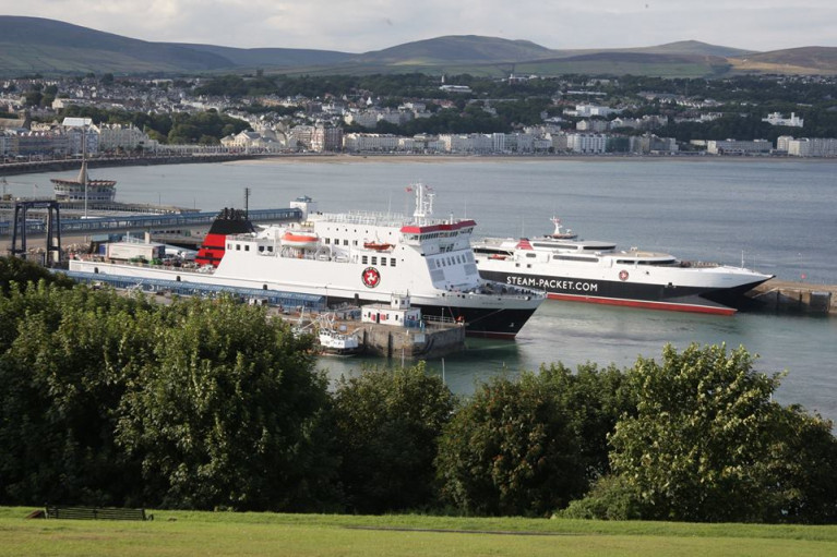
Ferry sailings of the Isle of Man Steam Packet were called off for the ro-pax Ben-my-Chree.
Sailings to and from the Island, reports Manx Radio, have been cancelled due to silt build up in Douglas Harbour.
The Steam Packet Company has pulled the 8.45am, Ben-my-Chree, crossing to Heysham and the return journey at 2.15pm.
It says the silt combined with an extremely low tide is to blame.
Overnight sailings were also affected with the Ben-my-Chree delayed leaving Heysham.
It's due back to Douglas at 10am, meaning today's newspapers will be late.


