Displaying items by tag: Storm Jorge
Calls For Surfers To ‘Foot The Bill’ For Rescues During Storm Conditions After Two Taken From Water In Storm Jorge

Calls have been made for people rescued from the water while going against safety advice and weather warnings to be “handed the bill” for their rescue, after two surfers were saved off the Sligo coast during Storm Jorge at the weekend.
The Irish Times reports that the two surfers were winched aboard the Sligo-based Irish Coast Guard helicopter Rescue 118 on Saturday morning (29 February) after one had lost his surfboard and another on shore had attempted to rescue him.
Storm conditions such as those presented by Storm Jorge — which prompted a Status Red marine warning for all Irish coastal waters — create the swells sought after by the big wave surfers regularly attracted to the Sligo coast, particularly at Mullaghmore, over the winter months.
But the situation on Saturday did not sit well with members of the public commenting online, who branded the surfers’ actions as “selfish” and “nonsense” and demanded they foot “the bill” for the launch of emergency services, or even face criminal prosecution.
The Irish Times has more on the story HERE.
Storm Jorge: Status Red Marine Warning For All Irish Coastal Waters
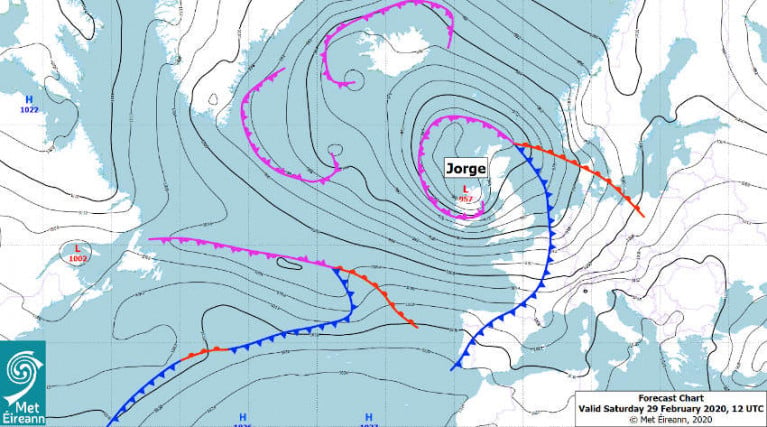
A Status Red marine weather warning is in place this morning (Saturday 29 February) as Storm Jorge brings southwesterly winds to gale or strong gale force on all Irish coastal waters.
Winds will veer westerly later this morning and this afternoon, increasing from gale force to storm force, and reaching violent storm force for a time between Loop Head and Erris Head.
On land, Met Éireann says the strongest winds will be experienced in Galway and Clare, reaching mean speeds of 85 to 100km/h in places this afternoon with gusts of 130 to 145km/h, and with an elevated rusk of coastal flooding.
“The combination of high seas and strong winds or stormy conditions associated with Storm Jorge may increase the possibility of coastal flooding, especially in flood-prone areas along the Atlantic coast on Saturday (particularly when coincident with high tides),” the meteorological service adds.
A Status Orange wind warning is in place for the rest of the country as severe winds, southwest quickly veering wet and later northwest, will reach mean speeds of 65 to 80km/h with gusts of 110 to 130km/h — possibly higher in very exposed areas — with an elevated coastal flood risk.
Heavy rainfall over this weekend is expected to compound flooding issues with water levels already elevated nationwide, particularly in the northern half and in the Midlands.
Among events schedules for this weekend that have been cancelled is the Lagan Head of the River rowing event, which may be rescheduled for later this year.
Storm Jorge Forces to Revise Tomorrow's Maiden Sailing Departure On New Ireland-Spain Route
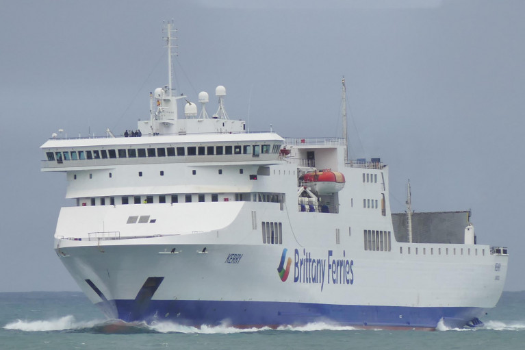
Bad weather has brought forward the departure time of Brittany Ferries maiden commercial crossing tomorrow on the new Rosslare-Bilbao, Spain route, writes Jehan Ashmore.
The looming weather system of Storm Jorge as named by the Spanish met office, has forced in the re-scheduling of the inaugural Brittany Ferries sailing on the new Ireland-Spain service. The launch of the Iberian service will be a first for the French operator to provide a passenger ferry service using Rosslare Europort.
Afloat has consulted the Brittany Ferries website (sailing updates) which cites due to poor weather, (the sailing from Rosslare at 23.30) will now instead depart at the earlier time of 11.00 (tomorrow morning), Friday, 28 February.
An expected arrival into Bilbao is at 08:00 on Saturday, 1 March and the operator added their apologies for the inconvenience caused. For the latest sailing information click here in addition to the operators Reservations Team on (021) 427 7801 (Mon - Fri: 09:00 - 17:30).
The new twice weekly Ireland-Spain route to be operated by ropax Kerry, replaced the Cork-Santander service which ceased recently after a two-year trial period when launched by ropax Connemara. The route received enouraging passengers numbers however Brittany Ferries added the closure arose from freight figures that were not robust and hauliers expressed better road connections and shorter driving distances.
In addition to the relocation of both Irish and Spanish ports, the Kerry will also serve Brittany Ferries which is to launch another new Rosslare to Roscoff route on a weekly return basis starting next month on Monday, 23 March.
This route in addition to Rosslare-Cherbourg was not revived in 2019 as Irish Ferries abandoned these French routes based out of the 'Europort' following the introduction of newbuild W.B. Yeats serving Cherbourg but out of Dublin Port from where the cruiseferry currently operates on the Irish Sea during the winter months to Holyhead. The company however on the St. Georges Channel continue to operate through the Wexford port to Pembroke Dock in Wales.
Likewise of the former Britanny Ferries Cork based route to Spain, Kerry will continue to provide an économie service ship to compliment the weekly seasonal offering from Cork to Roscoff, operated by flagship cruiseferry Pont-Aven.
Afloat this morning tracked Kerry having departed Santander for the final time last night as the ropax makes a repositioning crossing across the Bay of Biscay bound for Rosslare Europort.
The Cypriot flagged ropax is due to arrive in the Co. Wexford ferryport tomorrow morning around 07.30 and remain until the revised morning departure sailing to Spain.
Also tracked by Afloat is Pont-Aven which recently had a new engine installed while in dry-dock at the Remontowa Yard, Gdansk, Poland, following last year's fire on board as previously reported.
The incident caused damage to one of the ferry's port-side MAK 12VM43 engine units resulting in the cruiseferry running on the three remaining engines during 2019 which caused disruption and cancelled sailings. Also berthed nearby at the Polish shipyard is Irish Ferries cruiseferry Ulysses. Afloat will have more to report.
As for the resumption of Brittany Ferries Cork-Roscoff seasonal service, this is scheduled to start with the first inward sailing from France departing on Friday, 20 March. The corresponding outward sailing from Ringaskiddy in lower Cork Harbour is to take place the next day, Saturday, 21 March.


