Menu

Ireland's sailing, boating & maritime magazine

Displaying items by tag: BlueFish Project

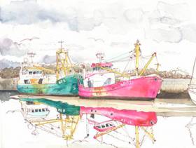
A series of watercolour illustrations and interviews have captured the importance of the ocean to coastal communities in Ireland and Wales as part of the EU-funded BlueFish Project.

Sharon Sugrue, scientific and technical officer at the Marine Institute, and Galway’s urban sketcher Róisín Curé visited coastal communities in Ireland and Wales that border the Irish and Celtic Seas.

They met with people from a broad spectrum of marine activities including fishing, aquaculture, leisure, transport, tourism and marine renewable energy.

“A key aspect of the project was speaking with people living and working in coastal communities, and gathering their opinions about climate change and learning about how it might affect their livelihoods,” Sugrue said.

“Along with interviewing people and documenting their daily interactions with the sea, the medium of art was also used to record their activities. This was a unique opportunity to talk directly to coastal communities and capture their perspectives through art.”

Róisin Curé produced a series of watercolour illustrations that captured snapshots of these coastal communities and people’s daily lives.

The results of the interviews and art, through watercolour illustrations, created an accessible way for the public to understand the importance the ocean has on livelihoods in coastal communities.

By engaging with people and industries dependant on the sea, the information gathered highlighted how they benefit from the ocean, their thoughts on climate change, and particularly how it was going to affect their lives and businesses.

Comments made by fishermen stated that without the ocean, they wouldn’t have a living, as it’s their only source of income in their rural parts of Ireland.

“Many of the stories reaffirmed the importance of the age-old relationship between people and the sea, noting that the sea is the life-blood which sustains these communities,” Sugrue said.

“The general consensus in both Ireland and Wales coastal communities was that climate change is happening. There was an acknowledgment and a realisation amongst the people interviewed that there was a real looming threat to their livelihoods.”

Many people commented on how they were seeing changes to their climate in their local communications. A local businessman from Anglesey said: “In the 38 years I’ve been working here, the road would have flooded twice a year. Now it floods much more often.”

Curé said: “I felt privileged to sketch, at close quarters, people whose ingenuity has turned a potentially hostile ocean into a source of income. I hope that the same ingenuity will provide the answers to the challenges we’re facing with the effects of climate change.”

In August 2018, the ports of Dingle in Co Kerry, Baltimore in Co Cork, Kilmore Quay in Co Wexford and Howth in Co Dublin were visited and fishermen, restaurateurs, shellfish producers, operators in the tourism sector and seafarers were interviewed.

The Welsh coastal communities were visited in October and included Anglesey, Bangor, Pwllheli, New Quay, Milford Haven and Pembrokeshire.

Sugrue added: “This project has given me the opportunity to engage with those living and working in coastal communities in a personal and hands on way.

“Growing up by the sea and being part of a family business in aquaculture, I felt an affinity with the people interviewed. It also brought home to me the effect that climate change could have in a ‘real sense’ showing how these effects could ripple through these communities.”

Linking science and art as a mechanism to convey the importance of the ocean to coastal communities and the potential impacts of climate change on these communities will continue throughout 2019, where the project will feature at maritime festivals in Ireland and Wales and continue the dialogue with these coastal communities.

The BlueFish Project is a partnership between six organisations in Ireland and Wales including the Marine Institute, University College Cork, Bord Iascaigh Mhara, Bangor University, Aberystwyth University and Swansea University.

The marine science research project is funded by the Ireland Wales 2014-2020 European Territorial Co-operation (ETC) Programme. The purpose of this maritime programme is to connect organisations, businesses and communities on the West coast of Wales with the South- East coast of Ireland.

Through engagement with coastal communities and art, the BlueFish Project, launched in September 2017, aims to develop knowledge and understanding of the marine resources and the potential impacts of climate change on the Irish and Celtic Sea ecosystem.

To find out more about the BlueFish Project, visit BlueFishProject.com

Published in Coastal Notes

About Dublin Port 

Dublin Port is Ireland’s largest and busiest port with approximately 17,000 vessel movements per year. As well as being the country’s largest port, Dublin Port has the highest rate of growth and, in the seven years to 2019, total cargo volumes grew by 36.1%.

The vision of Dublin Port Company is to have the required capacity to service the needs of its customers and the wider economy safely, efficiently and sustainably. Dublin Port will integrate with the City by enhancing the natural and built environments. The Port is being developed in line with Masterplan 2040.

Dublin Port Company is currently investing about €277 million on its Alexandra Basin Redevelopment (ABR), which is due to be complete by 2021. The redevelopment will improve the port's capacity for large ships by deepening and lengthening 3km of its 7km of berths. The ABR is part of a €1bn capital programme up to 2028, which will also include initial work on the Dublin Port’s MP2 Project - a major capital development project proposal for works within the existing port lands in the northeastern part of the port.

Dublin Port has also recently secured planning approval for the development of the next phase of its inland port near Dublin Airport. The latest stage of the inland port will include a site with the capacity to store more than 2,000 shipping containers and infrastructures such as an ESB substation, an office building and gantry crane.

Dublin Port Company recently submitted a planning application for a €320 million project that aims to provide significant additional capacity at the facility within the port in order to cope with increases in trade up to 2040. The scheme will see a new roll-on/roll-off jetty built to handle ferries of up to 240 metres in length, as well as the redevelopment of an oil berth into a deep-water container berth.

Dublin Port FAQ

Dublin was little more than a monastic settlement until the Norse invasion in the 8th and 9th centuries when they selected the Liffey Estuary as their point of entry to the country as it provided relatively easy access to the central plains of Ireland. Trading with England and Europe followed which required port facilities, so the development of Dublin Port is inextricably linked to the development of Dublin City, so it is fair to say the origins of the Port go back over one thousand years. As a result, the modern organisation Dublin Port has a long and remarkable history, dating back over 300 years from 1707.

The original Port of Dublin was situated upriver, a few miles from its current location near the modern Civic Offices at Wood Quay and close to Christchurch Cathedral. The Port remained close to that area until the new Custom House opened in the 1790s. In medieval times Dublin shipped cattle hides to Britain and the continent, and the returning ships carried wine, pottery and other goods.

510 acres. The modern Dublin Port is located either side of the River Liffey, out to its mouth. On the north side of the river, the central part (205 hectares or 510 acres) of the Port lies at the end of East Wall and North Wall, from Alexandra Quay.

Dublin Port Company is a State-owned commercial company responsible for operating and developing Dublin Port.

Dublin Port Company is a self-financing, and profitable private limited company wholly-owned by the State, whose business is to manage Dublin Port, Ireland's premier Port. Established as a corporate entity in 1997, Dublin Port Company is responsible for the management, control, operation and development of the Port.

Captain William Bligh (of Mutiny of the Bounty fame) was a visitor to Dublin in 1800, and his visit to the capital had a lasting effect on the Port. Bligh's study of the currents in Dublin Bay provided the basis for the construction of the North Wall. This undertaking led to the growth of Bull Island to its present size.

Yes. Dublin Port is the largest freight and passenger port in Ireland. It handles almost 50% of all trade in the Republic of Ireland.

All cargo handling activities being carried out by private sector companies operating in intensely competitive markets within the Port. Dublin Port Company provides world-class facilities, services, accommodation and lands in the harbour for ships, goods and passengers.

Eamonn O'Reilly is the Dublin Port Chief Executive.

Capt. Michael McKenna is the Dublin Port Harbour Master

In 2019, 1,949,229 people came through the Port.

In 2019, there were 158 cruise liner visits.

In 2019, 9.4 million gross tonnes of exports were handled by Dublin Port.

In 2019, there were 7,898 ship arrivals.

In 2019, there was a gross tonnage of 38.1 million.

In 2019, there were 559,506 tourist vehicles.

There were 98,897 lorries in 2019

Boats can navigate the River Liffey into Dublin by using the navigational guidelines. Find the guidelines on this page here.

VHF channel 12. Commercial vessels using Dublin Port or Dun Laoghaire Port typically have a qualified pilot or certified master with proven local knowledge on board. They "listen out" on VHF channel 12 when in Dublin Port's jurisdiction.

A Dublin Bay webcam showing the south of the Bay at Dun Laoghaire and a distant view of Dublin Port Shipping is here
Dublin Port is creating a distributed museum on its lands in Dublin City.
 A Liffey Tolka Project cycle and pedestrian way is the key to link the elements of this distributed museum together.  The distributed museum starts at the Diving Bell and, over the course of 6.3km, will give Dubliners a real sense of the City, the Port and the Bay.  For visitors, it will be a unique eye-opening stroll and vista through and alongside one of Europe’s busiest ports:  Diving Bell along Sir John Rogerson’s Quay over the Samuel Beckett Bridge, past the Scherzer Bridge and down the North Wall Quay campshire to Berth 18 - 1.2 km.   Liffey Tolka Project - Tree-lined pedestrian and cycle route between the River Liffey and the Tolka Estuary - 1.4 km with a 300-metre spur along Alexandra Road to The Pumphouse (to be completed by Q1 2021) and another 200 metres to The Flour Mill.   Tolka Estuary Greenway - Construction of Phase 1 (1.9 km) starts in December 2020 and will be completed by Spring 2022.  Phase 2 (1.3 km) will be delivered within the following five years.  The Pumphouse is a heritage zone being created as part of the Alexandra Basin Redevelopment Project.  The first phase of 1.6 acres will be completed in early 2021 and will include historical port equipment and buildings and a large open space for exhibitions and performances.  It will be expanded in a subsequent phase to incorporate the Victorian Graving Dock No. 1 which will be excavated and revealed. 
 The largest component of the distributed museum will be The Flour Mill.  This involves the redevelopment of the former Odlums Flour Mill on Alexandra Road based on a masterplan completed by Grafton Architects to provide a mix of port operational uses, a National Maritime Archive, two 300 seat performance venues, working and studio spaces for artists and exhibition spaces.   The Flour Mill will be developed in stages over the remaining twenty years of Masterplan 2040 alongside major port infrastructure projects.

Source: Dublin Port Company ©Afloat 2020.