


Displaying items by tag: Blueway
Waterways Stakeholder Partnership Announces Ambitious Plans for Ireland’s Blueways
An ambitious action plan has been launched to drive forward blueways across the island of Ireland.
Blueways encourage the the use of lakes, canals, rivers and sheltered coastal environments for kayaking, canoeing, stand-up paddleboarding, walking and cycling while connecting with nature and heritage.
They are aimed at the low to no-skilled ‘dabbler’ and therefore activity providers, eateries, accommodation and attractions all perform a key role in animating the experience.
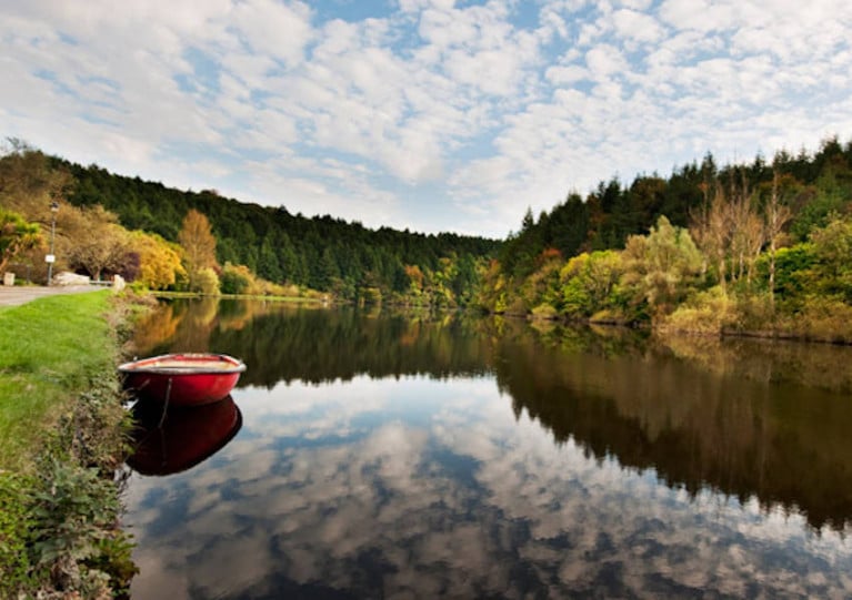
There are currently four accredited blueways in Ireland: the Boyne Blueway, Suir Blueway in Tipperary, Lough Derg Blueway and now the Arranmore-Burtonport Blueway in Donegal.
The three-year Blueway Partnership Action Plan sets out key actions to ensure the successful development, promotion, management and maintenance of additional high-quality blueways so that locals and visitors can consistently and sustainably enjoy animated experiences on or close the water.
Consisting of Fáilte Ireland, Sport Ireland, Waterways Ireland, Sport Northern Ireland and Tourism Northern Ireland, the Blueway Partnership has the stated ambition to grow the network of accredited blueways from four to 10 by 2025.
To reflect this, a key initial step has been the establishment of new Blueway Coordinator and Development Advisor roles which will provide the dedicated resource required to support the delivery of the Action Plan and the Blueways Partnership. Outdoor Recreation Northern Ireland has been appointed to this role.
Along with a sustained effort to develop more blueways, the Action Plan also highlights the need to also support the management, promotion and animation of existing blueways.
According to its authors, the Action Plan also ensures the Blueway Partnership is well positioned to respond to the growing public demand for quality infrastructure close to water and nature.
Tender for Galway/Mayo Blueway Feasibility Study
The Connaught Telegraph reports that Galway city councillors are tendering for a study on the feasibility of a new blueway for Galway and Mayo.
According to details on the State’s eTenders website, the proposed blueway would extend from Lough Mask to Galway Bay along the River Corrib and associated inland waterways, and include a zone some 5-10km inland.
The deadline for submissions is noon next Friday 11 June with the prospective contractor expected to conduct an analysis of the potential economic and social benefits of such a blueway, among other requirements.
Barrow Blueway Works Get Under Way Next Month
The start date for works on the proposed Barrow Blueway has been announced by Kildare County Council in conjunction with Laois County Council and Waterways Ireland.
When complete, the scheme will provide a multi-activity 46km off-road, flat and accessible public space and leisure route along the inland waterway – together with approved paddling trails for on water access – running from Lowtown in Kildare, through the towns of Rathangan, Monasterevin, Vicarstown, to Athy.
The proposed upgrade will improve access to the beautiful Barrow Way, both on and along the water, offering an enhanced experience to walkers, cyclists, wheelchairs users, paddlers and families.
Works are to commence on Wednesday 15 July at Milltown Bridge, some 3km north of Athy, with localised closures to facilitate the upgrade of the towpath. The duration of works this year will be around 16–18 weeks.
The works will be carried out in accordance with all environmental and planning conditions and under the oversight of an ecological clerk of works, to ensure any potential negative environmental impacts are avoided and ecological mitigation is implemented in accordance with legislation and best practice.
What’s being touted as a “top tourist attraction” is due to be complete early 2022 and “will not only offer a huge economic boost, positively influencing economic growth opportunities, it will also increase that sense of community, create exciting opportunities for both recreation and ways to experience many of the community's interesting places from new perspectives”, according to the project partners.
Kildare County Council will keep the public updated as works progress on the blueway scheme, which is funded by the Government of Ireland under Project Ireland 2040.
Barrow Locals Say What River Needs Is Promotion, Not Blueway
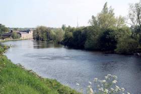
Proposals for a new blueway along the River Barrow have been blocked by planners who objected to the scheme for a hard surface along the 115km of towpath.
But as The Irish Times reports, many locals and users of the waterway believe what the Barrow and the communities along its reach really need are better promotion.
Earlier this month, An Bord Pleanála rejected plans long in the offing for the Barrow Blueway, a new cycling and walking path between Lowtown in Co Kildare and St Mullins in Co Carlow.
Hundreds of Barrow locals had their say at public meetings, with campaigners against the path plans — among them broadcaster Olivia O’Leary — citing the existing grassy surface as more than suitable for walkers.
Others saw the blueway as “a fantastic opportunity” to save business such as pubs which have been closing at a rapid rate in rural areas, and raised the question of boggy or overgrown stretches that are a deterrent to visitors.
But others still argue that with proper maintenance and a weight of a promotional campaign behind it, the existing path would prove a major tourism attraction both domestically and abroad.
“I have people coming from the States, Canada, Australia, Europe, UK and they are just flabbergasted at how incredibly gorgeous it is, and they can’t believe there is nobody on it,” said local canoe tour operator Charlie Horan.
Those sentiments are shared by environmental journalist Lenny Antonelli, who tweeted that the Barrow is “already walkable, paddle-able and often cycle-able too.
It's already walkable, paddle-able and often cycle-able too. The #Barrow doesn't need a greenway, but it does need better marketing & promotion, particularly within Ireland, and better facilitates for visitors. Imagine if all its derelict lock cottages became bothies for example?
— lenny antonelli (@lennyantonelli) April 29, 2019
“The Barrow doesn't need a greenway, but it does need better marketing and promotion, particularly within Ireland, and better facilitates for visitors. Imagine if all its derelict lock cottages became bothies for example?”
The Irish Times has more on the story HERE.
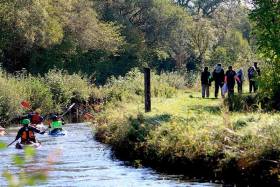
First Phase Of Lower Bann Blueway Up And Running
#InlandWaters - The proposed Blueway route between Toome and Coleraine along the Lower Bann corridor as moved a step closer to fruition as work was recently completed on Phase One of the project at Glenone.
In the joint venture between Mid Ulster District Council and Waterways Ireland, supported by Angling NI, Honourable Irish Society, National Coarse Fishing Federation of Ireland and local landowner William Chesney, a new multi-use public path along the riverbank was developed.
This accesses an additional 25 coarse angling stands installed as part of the phased works that complement the existing 89 angling stands and associated facilities already at the site, known locally as Molloy’s Ford.
The work, delivered by Mid Ulster District Council, completed by IL Contracting and project managed by Robinsons & Sons, Ballymoney, was made possible by funding from Waterways Ireland and is part of a proposal to develop a Blueway route from the town of Portglenone to Newferry West, a length of approximately 7km.
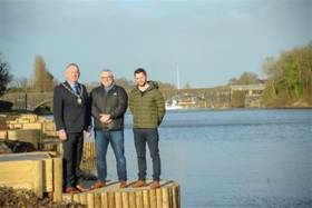
Chair of Mid Ulster District Council, Councillor Sean McPeake, welcomed the development, saying: “The council recognises the importance of sensitively and appropriately maximising the potential of our natural attractions, such as the Lower Bann flowing through our district, and this project is an example where building collaborative partnerships has resulted in an improved river corridor that will generate and sustain a vibrant and healthy community and economy.
“As well as providing recreational walking, cycling, running and angling opportunities to local people, the site will see international visitors in June when it hosts the 2019 FIPSed 25th European Coarse Angling Championship.”
Waterways Ireland’s Stephen Douglas said of this first phase: “It has brought together a wide range of stakeholder partners in delivering what is the first phase of establishing a Blueway path between Portglenone and Newferry and provision of infrastructure to host the 2019 European Coarse Angling Championship. Our vision is to develop Blueway infrastructure, where possible, along the full length of the Lower Bann River.
“To this end we hope to continue working with our partner organisations to develop the product, gain statutory approvals and pursue funding. Blueways developed to date along our navigations have proven to engage local communities and visitors alike and have contributed significantly in economic and social regeneration of towns and communities along our waterways”.
Blueways are a network of multi-activity recreational trails, based on or alongside idyllic inland waterways, which provide scenic routes into the heart of the countryside traversed by canoe, bike or on foot. Their value lies not only in the recreational opportunities that they offer residents and visitors, but also in their potential to stimulate local businesses and regenerate local areas.
For more information on the project, see www.midulstercouncil.org
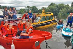
Water Activity Zone Coming To Enniskillen Blueway
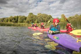
#InlandWaters - That new Enniskillen Blueway water activity zone located beside Erneside footbridge will be opening soon.
A range of family-friendly water activities including canoeing, kayaking and stand-up paddle boarding will be offered at the zone developed by Waterways Ireland with the support of Fermanagh & Omagh District Council, Fermanagh Lakeland Tourism and Enniskillen BID.
If you would prefer to captain your own boat and enjoy a leisurely experience around Ireland’s only island town, you might be more interested in one of the ‘wee red boats’ from Erne Boat Hire.
There is also a new heritage boat tour taking in the monastic and heritage sites around Enniskillen including Devenish Island, and the Erne Water Taxi for a more exhilarating blast around Lough Erne.
Waterways Irelad hopes the new water activity zone will play a role in encouraging young people to access the water, engage in water sports and make a connection with Lough Erne.
The activity zone also forms part of ongoing blueway developments on Lough Erne, the first of which will be a canoeing trail from Bellanaleck to Troy, taking in Enniskillen town and the new activity zone.
#InlandWaters - Tourism and activity providers along with local communities along the route are invited to attend a series of workshops aimed at developing the Royal Canal as an attraction for domestic tourism and visitors from abroad.
Coming ahead of next year’s launch of the Royal Canal Greenway, the capacity-building workshops will help project partners engage with local trades, businesses and others to showcase the proposed plans in developing the Royal Canal as a destination.
The long-awaited Blueway and Greenway trails on and along the 144km of canal and towpath from Dublin to Longford will be the focus of the workshops, the first of which will be held next week in Mullingar on Thursday 24 May from 6.30pm at the Mullingar Park Hotel.
Dates and venues for subsequent workshops in Longford town, Maynooth and Dublin are to be confirmed. All are hosted by Waterways Ireland with the respective local authorities.
Once complete, the Royal Canal Greenway will be the longest off-road walking and cycling trail on the island of Ireland.
Accompanying this will be a series of Blueway developments, the first being located in Mullingar where a 22km paddling trail and activity hub will be established.
The workshops will encourage the development of activity based packages, dining and accommodation packages and promotional materials which will activate the region and place the product in the ‘shop window’ for both the domestic and international tourist.
The Royal Canal is also at the heart of Ireland’s Ancient East and Ireland’s Hidden Heartlands, two tourism initiatives developed by Fáilte Ireland.
Enniskillen Blueway Activity Hub Now Open For Business
#InlandWaters - The newly opened Enniskillen Blueway Activity Hub offers a range of activities from guided canoeing and kayaking tours to electric bike hire, day boat hire and water taxi tours.
Developed by Waterways Ireland with the Enniskillen Business District and based at its offices on Sligo Road along the River Erne, the new hub makes Fermanagh’s county town the perfect base to explore Lough Erne and the wider Lakelands region.
Full details, maps and pricing are available at www.bluewaysireland.org
Shannon–Erne Blueway Launched in Ballyconnell, Co Cavan
Minister Heather Humphreys T.D., in conjunction with broadcaster & fitness expert Karl Henry, Waterways Ireland Chief Executive Dawn Livingstone and Cavan County Council Cathoirleach Paddy Smith has launched the Shannon-Erne Blueway in Ballyconnell, Co Cavan. The Shannon-Erne Blueway adds significantly to the network of Blueway trails that Waterways Ireland has developed along the navigations.
The Shannon–Erne Blueway runs from Leitrim Village to Belturbet and includes 70km of water trail and over 17km of linear and looped walking and cycling routes. The Shannon-Erne Blueway provides a range of recreational leisure activities such as paddling, walking and cycling all linked by the waterways to local towns and villages.
Minister Humphreys stated “This is a wonderful amenity which is a great addition to Cavan and Leitrim’s tourism offering. The development of Blueways across the country is an important element of the Government’s tourism strategy. Towns and villages along the Shannon-Erne route will now be able to capitalise on the increased level of visitors who will come to the region to use the Blueway for a range of recreation activities. More visitors will bring more revenue for local businesses and should boost local job creation. I would like to commend Waterways Ireland, the local authorities and the tourism agencies which have collaborated to bring this project to fruition.”
The Shannon-Erne Blueway has the potential to have a very positive impact on jobs and the regional economy. The Mayo Greenway, which is now in its 6th year of operation, has seen a jump in visitor numbers from 80,000 in 2011 to 300,000 in 2014. That means an extra €5 million was brought into the region. With the market for off road adventure tourism is growing here in Ireland and internationally, Cavan and Leitrim are in a prime position to benefit from this trend.
The launch of the Blueway will allow local businesses to capitalise on an increase in demand for transport, equipment hire, accommodation and entertainment.
Paddy Smith, Cathoirleach Cavan County Council said ' I’m very proud to be here today in Ballyconnell to launch the new Shannon – Erne Blueway . Cavan is blessed with a network of scenic waterways which can rival any in the country. We are delighted to link in with Waterways Ireland and Leitrim County Council to develop and promote the new Blueway linking the Shannon and Erne Rivers. The opportunities for recreational activities along the Blueway are many and we’re confident that visitors will want to experience all that it has to offer’
The Shannon Erne Blueway is a new concept where a myriad of recreational activities have been developed and bundled together as a single or multiple visitor experience and tourism proposition. Waterways Ireland has, using the wonderful waterway assets, also developed and built a paddling trail from Drumshanbo through Battlebridge and Leitrim Village to Carrick on Shannon.
The Shannon-Erne Blueway is being delivered by Waterways Ireland in partnership of the Cavan County Council, 'This is Cavan', Canoeing Ireland, Leitrim County Council, Leitrim Tourism and Fáilte Ireland.
Chief Executive Dawn Livingstone confirmed that partnership was the key to delivering the Shannon Blueway "Waterways Ireland provides world beating facilities and services on the Shannon Navigation and Shannon-Erne Waterway. Through our partnership with the National Trails Office, Canoeing Ireland, Cavan County Council, 'This is Cavan', Leitrim Tourism and Leitrim County Council an outstanding multi-activity product has been built in the Shannon-Erne and Shannon Blueways which is now being packaged by clubs and communities for their recreational activities and companies and organisations for domestic and international tourists. Partnership is key to delivering the future of the Shannon Blueway further into Roscommon, Longford and on down the Shannon as well as north onto Lough Erne."
The Shannon Erne Blueway is at the heart of 200km of paddling area, looped and linear walks.
Shannon Blueway Launch of The Camlin Loop
#inland – Minister of State for Tourism and Sport, Michael Ring TD, announced the opening of the Shannon Blueway: Camlin Loop today with walkers and paddlers taking to the Shannon Blueway, in Clondra, Co Longford.
The Shannon Blueway is the first of its kind in Ireland where a myriad of recreational activities have been developed and bundled together as a single or multiple visitor experience and tourism proposition. Waterways Ireland has, using the wonderful waterway assets, developed and built a canoe trail looping from Clondra through Tarmonbarry back to Clondra. Longford County Council and Longford Tourism have also developed 16km of multi-activity trail adjacent to the Royal Canal from Clondra into Longford with plans to expand those trails.
At the official opening Minister Michael Ring TD said: "I am delighted to be launching this project here in Longford today. The Shannon Blueway: Camlin Loop has the potential to have a very positive impact on jobs and the regional economy. The Mayo Greenway, which is now in its 5th year of operation, has been a success and had contributed to increased economic activity in the region. With the market for off road adventure tourism growing here in Ireland and internationally, Longford is in a prime position to benefit from this trend. The launch of the Blueway will allow local businesses to capitalise on an increase in demand for transport, equipment hire, accommodation and entertainment. I would like to commend Waterways Ireland for this initiative, which I have no doubt will have a very positive impact on the region."
The Shannon Blueway is being delivered by Waterways Ireland in partnership with the Irish Sports Council, Canoeing Ireland, Longford County Council, Longford Tourism and Fáilte Ireland.
Mark Casey, Cathoirleach of Longford County Council stated "I would like to take the opportunity to congratulate Waterways Ireland and Longford County Council on the development of the Blueway product here in Longford. This 10km Loop along the Camlin River will provide both land and water based recreational opportunities for visitors, in turn boosting our tourism numbers, whilst providing the local community with access to our County's wonderful natural infrastructure. It will also serve to stimulate the local economy by providing opportunities for service providers and new businesses. Longford Tourism is to be commended for their efforts with this inaugural Longford Blueway Festival, which has already generated significant interest and gained support from local agencies and voluntary groups. It promises to be a wonderful weekend of activities for all and the Longford Blueway itself will be a key asset to the County going forward'.
The wider Shannon Blueway of which the Camlin Loop is part, is at the heart of access to 200km of paddling area on the Shannon and Royal Canal, walking and cycling are on the canal towpath to Longford and long distance trails to the East and Dublin
Chief Executive Dawn Livingstone confirmed that partnership was the key to delivering the Shannon Blueway "Waterways Ireland has invested significantly in creating world beating facilities and services on the Shannon Navigation. Through our partnership with the National Trails Office, Canoeing Union, Longford Tourism and Longford County Council an outstanding multi-activity product has been built in the Shannon Blueway which is now being packaged by clubs and communities for their recreational activities and companies and organisations for domestic and international tourists. Partnership is key to delivering the future of the Shannon Blueway further into Longford, and indeed into Roscommon and Westmeath."


 at Dublin when bound for Holyhead; such high-speed craft 'seasonal’ services resume next month")
 Michael Murphy Schull Harbour Sailing Club (SHSC), Eric Coogan Heineken Ireland, Mark Murphy, Commodore SHSC, Jack Allen SHSC, Carmel O'Regan SHSC, Cornelious Ndlovu, Schull Harbour Hotel Operations Manager and Derval Murphy SHSC")

, marking also a first presence in this market.")


