


Displaying items by tag: Gweebarra
Permit Reminder For Anglers As Gweebarra Fishery Opens
#Angling - Inland Fisheries Ireland says it is fully committed to the ongoing protection of the Gweebarra fishery in accordance with the High Court judgement of Justice Laffoy delivered on 19 December 2012.
Anglers wishing to fish the Gweebarra fishery from the opening of the angling season tomorrow (Saturday 1 April) are required to have a valid licence and permit, which are available from the village shop in Doochary, Glenties Angling Centre (phone 074 955 1141) or online from Donegal Angling Holidays.
A halt on fishery offence summonses, as previously reported on Afloat.ie, has prompted IFI to withdraw a number of cases, including those related to the Gweebarra fishery which were before the Donegal courts in recent days.
However, in the interim all current provisions and offences of the Inland Fisheries Acts continue in fill force and effect, and any alleged offenders remain liable to prosecution.
Angling Guides to Donegal's Gweebarra & Eany Rivers Launched

Inland Fisheries Ireland (IFI) has released two new angling guides for salmon and sea trout angling on the Gweebarra and Eany Rivers in Co. Donegal.
The Gweebarra River Angling Guide
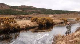
The Gweebarran River is a highly productive salmon and sea trout fishery situated in west Donegal. It is a spate fishery, containing excellent fly-fishing water over its entire length with numerous holding pools, including the famous Mayo Pool, where the Cloghanagore River enters the main river.
The new angling guide, which comes as a fold-out water-resistant leaflet, provides detailed beat maps for the Gweebarra River fishery which extends for 13 kilometres from Lough Barra to Doochary village at the head of the tide.
Key angling stretches, holding pools and access points are identified for each of the beats in addition to further information regarding fishing methods, relevant angling regulations and locations at which visiting anglers may obtain licences and permits to fish.
Dr Milton Matthews, Director, Inland Fisheries Ireland, commented: “IFI would like to acknowledge the ongoing assistance of the Gweebarra Fishing Club which provided much of the background information regarding local place names and fishing pools utilised in the production of the guide. It is hoped that the new guide will provide a valuable reference for local and visiting anglers alike in the promotion of the Gweebarra fishery for the enjoyment and benefit of all.
“The new angling guide represents the culmination of the extensive capital investment and development of the Gweebarra fishery over recent years to conserve fish stocks, improve angling access and establish a wheelchair accessible section at Doochary village. The progress to date in upgrading and marketing of the fishery could not have been achieved without the ongoing support of the local fishing club and community.”
The Eany River Angling Guide
The second guide provides information on the Eany River, a spate river draining the Bluestack Mountains in south Donegal and flowing into Inver Bay. The Eany is a spate river system with peak angling activity typically coinciding with grilse and sea trout runs from June to September.
The Eany fishery, which includes the main river together with the Eanybeg and Eanymore tributaries, comprises more than 20 kilometres of varied angling water suitable for fly-fishing, spinning and bait (worm only) fishing. (Please note: The Eany River is currently listed on conservation grounds for catch and release angling only, so angling is restricted to use of single barbless hooks only with worm fishing banned).
The guide comes as a fold-out water-resistant leaflet suitable for outdoor use, and provides a detailed map of the Eany River fishery identifying key angling stretches, holding pools and suitable access and parking points along the fishery. It also provides information regarding fishing methods, relevant angling regulations and locations at which visiting anglers may obtain licences and permits to fish.
Both the Eany and Gweebarra Angling guides are available from Inland Fisheries Ireland (IFI) offices in Glenties or Ballyshannon during the season or can be downloaded directly from the IFI website here
High Court Rules In Favour of IFI In Gweebarra Fishery Dispute
#Angling - Judgement in the first module of a High Court trial over a long-running dispute between Inland Fisheries Ireland (IFI) and local anglers at the Gweebarra fishery has been found in favour of the fisheries agency.
Ms Justice Laffoy delivered her judgement on Wednesday 19 November in the first part of a modular trial sought by IFI "to allow key issues to be determined in this first module with the objective of saving court time and costs".
The first module related to what IFI said are the most important sections of the Donegal fishery (both State and privately owned) that it manages - such as the well-known 'Mayo Pool'.
A key claim by defendants Peadar O'Baoill and others - who are opposed to changes in fishing arrangements introduced by IFI (then the Northern Regional Fisheries Board) in 2007 - was that they had acquired rights to fish freely without permits at the Gweebarra fishery by virtue of angling freely there for many years prior to the regulation changes five years ago.
IFI argued that if such rights were upheld, it would have made the 2007 arrangements "unworkable" as the rod management plan central to the changes was dependent on regulation by issue of permits.
However Ms Justice Laffoy rejected the defendants' claim in this regard, saying: “The reality is that the defendants have not established any right, public, or otherwise, to fish in the freshwater part of the Gweebarra River, including the part thereof the subject of this module.”
The court also determined conclusively that IFI has the right to manage, control and regulate both the State-owned and privately held freshwater sections of the Gweebarra fishery.
In her concluding remarks, the judge urged both parties to resolve their remaining dispute locally and out of court.
Commenting after the trial, IFI repeated its "previously stated position that it has absolutely no wish to be involved in proceedings of this nature and remains committed to the protection of the Gweebarra fishery in its entirety, the public portion of which is a state asset.
"It welcomes any initiative which will allow for sustainable management of the fishery into the future. It is happy therefore to seek to resolve the remainder of the dispute, but such would have to be found in the context of existing legal agreements with other stakeholders."
Bridge Restored Thanks to Gweebarra Fishing Club
Volunteers from the Gweebarra Fishing Club have completed work on a footbridge across the river near Doochary, the Donegal Democrat reports.
The new bridge is part of a three-year project to develop accessibility on the riverside for walkers and anglers alike. Inland Waterways.
Club chairman Thomas Monds commented: "There’s been nothing there since the flood swept [the old bridge] away years ago. But with the club getting going and more and more local people getting involved, we thought this was a good chance to do something."
He added: "The footbridge makes both banks of the Gweebarra accessible to both anglers and walkers, without having to retrace yours steps."
According to Monds, the new bridge in tandem with recent enhancements in the local fishery infrastructure have helped to make Gweebarra "one of the most accessible and attractive angling venues in the country".
The Donegal Democrat has more on the story HERE.


 at Dublin when bound for Holyhead; such high-speed craft 'seasonal’ services resume next month")
 Michael Murphy Schull Harbour Sailing Club (SHSC), Eric Coogan Heineken Ireland, Mark Murphy, Commodore SHSC, Jack Allen SHSC, Carmel O'Regan SHSC, Cornelious Ndlovu, Schull Harbour Hotel Operations Manager and Derval Murphy SHSC")

, marking also a first presence in this market.")


