


Displaying items by tag: Marine Protected Areas
Marine Protected Areas Must Not Be Decided Only By Civil Servants
Where will marine protected areas and marine conservation zones be located in Irish coastal waters and what effects will they have on sailing, watersports generally, angling, commercial fishing, shipping?
The Marine Environment Section in the Water Division of the Department of Housing, Local Government and Heritage appears to be the ‘lead’ in decision-making about the location of these areas, on which work is underway this month, following the passing of the Marine Areas Planning Bill by the Oireachtas in mid-December. This Department described the passing of that Bill as “the biggest reform of marine governance since the foundation of the State.”
Another State agency, MARA, is being set up which will focus on offshore wind projects, water and wastewater infrastructure, bridges, marinas, coastal protection works, flood relief works and undersea telecommunications cables and power interconnectors. As far as I can determine at present, there 27 offshore wind farms planned for Irish coastal waters. Already there have been threats of legal action from commercial interests against some effects of the new Marine Planning Bill.
 Who will decide the Marine Protected Areas?
On my Podcast this week, I’m focusing on how decisions will be made about the marine protected areas. In an island nation, the Department of the Marine does not have the leading role in making major maritime decisions. The Chief Executive of the Irish Whale and Dolphin Group, a strong voice about the marine environment, says that “distant civil servants” not be allowed “foist these new designations” upon the maritime community.
Listen to the Podcast here
Ireland has joined an international agreement to establish a marine protected area (MPA) in the North Atlantic Current and Evlanov sea basin.
The area is located in the high seas, to the west of the Ospar maritime area in the north-east Atlantic.
It covers 595,196 km² - over eight times the size of Ireland’s land area.
The designated area is home to up to five million seabirds across 21 different species, including five – such as the Atlantic Puffin – that are globally threatened.
Other threatened species, like the wide-ranging Basking Shark and Leatherback Turtle, also inhabit the ocean area.
Ireland’s commitment to the new MPA was announced on Friday by Minister of State for Heritage and Reform Malcolm Noonan at an Ospar ministerial meeting in Cascais, Portugal.
The Ospar Commission for the Protection of the Marine Environment of the North-East Atlantic, an international organisation, has been chaired by Ireland since 2018.
The commission also approved a North-East Atlantic Environment Strategy.
It has 12 strategic objectives and over 50 practical, operational objectives to tackle the triple challenges of climate change, biodiversity loss and pollution (including marine litter) facing the oceans,Mr Noonan said.
Its implementation will be part of Ospar’s contribution to the achievement of the United Nations 2030 Agenda for Sustainable Development, Noonan said.
Two Government ministers have called on people to give their views on the expansion of Ireland’s marine protected areas (MPAs) before the deadline at the end of this week.
Minister for Housing, Local Government and Heritage, Darragh O’Brien and Minister of State for Heritage and Electoral Reform Malcolm Noonan issued the appeal with five days to go to close of submissions this Friday, July 30th.
MPAs are geographically defined maritime areas with certain protections for conservation purposes. The Government aims to expand Ireland’s MPA network from 2.13% to 30% of Ireland’s maritime area by 2030.
“Expanding Ireland’s MPA network will constitute a major change in marine environmental protection in Ireland. At present, there is no definition of an MPA in Irish law. Environmental protections under the Wildlife Acts only apply to the foreshore. Protection in marine areas beyond 12 nautical miles is limited, both in terms of space and species,”the two ministers state.
They have asked members of the public, stakeholders, industries and others for their views on the final report of the MPA advisory group, which was chaired by Prof Tasman Crowe of UCD’s Earth Institute.
The reports note that in addition to conserving marine species and habitats, MPAs can support maritime economic activity and reduce the effects of climate change and ocean acidification.
The report quotes economic data showing Ireland’s ocean economy has a turnover of €6.2 billion and provides stable, sustainable work for 34,132 full-time equivalent employees.
“Ireland, along with the rest of the world, faces the twin crises of climate change and accelerating biodiversity loss on land and at sea,” O’Brien said.
“The Government has a vision of clean, healthy, diverse and productive oceans and seas around Ireland. Over the last five months we have received a strong number of submissions, from a range of groups and people of all ages and backgrounds, on the advisory group’s report on progressing our vision of healthier seas,” he said.
"The submissions we receive now will inform our legislation on the identification, designation and management of MPAs. That work will begin later this year,” he said.
The Government recently published Ireland’s first National Marine Planning Framework and approved the Maritime Area Planning Bill.
It proposes to establish in law a new development consent regime for the maritime area.
Both the new forward planning model, envisaged by the Bill, and an expanded MPA network, will secure the NMPF’s objectives, the ministers state.
Ten Days to Close of Marine Protected Areas Consultation - An Taisce Clean Coasts Hosts Workshop
With just ten days to go in the public consultation on marine protected areas, An Taisce’s Clean Coasts programme is reminding people to “have their say”.
Ireland currently protects just over two per cent of territorial waters, and the Government has committed to expand this to ten per cent “ as soon as is practical”.
The Government aims to have 30 per cent of waters designated as marine protected areas (MPAs) by 2030.
A public consultation on MPAs initiated by Minister for Housing Darragh O’Brien and Minister of State for Heritage Malcolm Noonan closes on Friday, July 31st at 5 pm.
Clean Coasts is hosting a workshop this Thursday, July 22nd to address any issues arising from the public consultation.
It says that scientific research shows that MPAs – as in areas of the ocean where certain activities are not allowed or strictly regulated - are one of the most beneficial tools to safeguarding the ocean, protecting biodiversity and increasing fish stocks.
Noonan has added his voice this week to the Clean Coasts appeal for public participation,
“We’re still fortunate in Ireland to have a productive, awe-inspiring and beautiful marine environment. But that environment is under increasing threat,” he has said.
“You have a vital role to play in shaping its future. I’m asking you to act now and have your say in how we protect our seas and ocean - in the short term and in the long term,” he has said.
Clean Coasts is a charity programme, run through An Taisce’s environmental education unit, and engages communities in the protection of Ireland’s beaches, seas and marine life.
Currently, there are over 1400 registered Clean Coasts volunteering groups, which participate in. hundreds of beach clean-ups and remove considerable quantities of marine litter from shorelines and waterways.
Book a spot for the Clean Coasts workshop here
The MPA public consultation is here
Sandycove’s young beach cleaner Flossie Donnelly joined a protest at the Dáil yesterday (Wednesday 7 July) calling for Government action to protect Ireland’s marine environment.
The Irish Wildlife Trust and members of the activist network Extinction Rebellion were also present at the demonstration marching to the gates of Leinster House, as the Irish Examiner reports.
And a spokesperson for the former warned that Ireland’s inshore waters “are under immense pressure” from pollution and fishing activities.
Fantastic fishy XR protest outside the Daíl followed by a floating protest down Grafton Street ?@noonan_malcolm PLEASE protect our marine areas, our marine life is dying! OR the giant fab fish tank will be back again !!! pic.twitter.com/IwtIcnnj24
— flossieandthebeachcleaners (@flossiebeachcl1) July 7, 2021
The protest comes just days after the Government launched its National Marine Planning Framework and published the Maritime Area Planning Bill, and weeks ahead of the closing date in a public consultation on expanding Ireland’s Marine Protected Areas that’s been welcomed by organisations such as the Irish Whale and Dolphin Group.
As reported on Afloat.ie, Government officials recently expressed concerns at the low level of feedback from stakeholders in the fishing and aquaculture sectors.
Government Concern Over Low Levels of Feedback from Fishing & Fish Farming on Marine Protected Area Consultation
Government officials seeking public views on an expansion of marine protected areas (MPAs) have expressed concern at the low level of feedback so far from the fishing and fish farming sectors.
Officials at the Department of Housing, Heritage and Local Government have also defended a government decision to publish legislation on marine planning separately to and well in advance of legislation on MPAs - stating that they involve two separate procedures.
Ireland’s first marine planning bill and a national marine planning framework are due to be published in Dublin on July 1st, while work on drawing up legislation for MPAs will only begin in the autumn.
Drafting of enabling legislation for MPAs is expected to take “most of 2022” to complete, department officials told a press briefing yesterday.
MPAs are geographically defined maritime areas with certain protections for conservation purposes.
The government aims to expand a network of MPAs to cover 30% of Ireland’s total maritime area of 488, 762 square kilometres by 2030 – in line with EU Biodiversity Strategy commitments to tackle climate change, the loss of biodiversity and the impact of pollution, including plastics and microplastics.
Up to 300 submissions had been received to date in the public consultation, which closes on July 30th.
A department consultant said that there was a “strong component” of online submissions from the environment and climate NGO sector.
However, he expressed concern that agriculture, aquaculture and fisheries were a “little under-represented”.
“So we are trying to focus some of our emphasis on reaching out and achieving a balance among wide range of occupations,” he said.
Current Irish MPA coverage amounts to 2.13 per cent or 10,420 square kilometres, and existing legislation covers the 12-mile limit - but new legislation is required for offshore.
However, the definition of 30 per cent still had to be defined, as it may relate to spatial coverage or certain or all parts of a habitat for sensitive species, they said.
Nor will there be a “big reveal of a map”, as the procedure will be an ongoing one involving both scientific advice and stakeholder consultation, officials stressed.
Offshore wind farms will be in place before MPAs, but officials envisaged designation of sensitive habitats did not necessarily involve ceasing all activity therein.
Offshore wind farms would have a prohibition on bottom trawling, and thus the farms could “co-exist” with MPAs, the officials said.
The public consultation was initiated in February by housing, heritage and local government minister Darragh O’Brien and his junior counterpart Malcolm Noonan after publication of an expert advisory group report, chaired by Prof Tasman Crowe of University College, Dublin’s Earth Institute.
One of the report’s key recommendations was that legislation for MPAs would be required.
The report also considered the role of an additional type of managed site which can contribute to marine biodiversity and long-term area-based conservation.
These “other effective area-based conservation measures” can be used to protect historical wrecks, spawning/nursery grounds for commercial fish or manage renewable energy sites.
The department says that responses to the consultation will help “inform the process of defining and setting out in clear legal terms what types of ongoing area-based protection in the sea are appropriate for Ireland”.
The consultation will also inform “how coastal communities, sectoral interests and the wider public will be involved, and an expanded network of MPAs can be managed”, it says.
A link to the online survey on MPAs is here
The Irish Whale and Dolphin Group (IWDG) says it welcomes the new public consultation on expanding Ireland’s Marine Protected Areas.
As previously reported on Afloat.ie, the Government is aiming to have 30% of Ireland’s maritime area designated as Marine Protected Areas (MPAs) by 2030.
Current coverage is just 2.13%, the IWDG says, adding that there is at present no definition of an MPA in Irish law.
“We wish to see Ireland achieve their international commitments and legal obligations, and create a truly ecologically coherent network of well-managed and well resourced MPAs, that is representative and connected,” says Sibéal Regan, the IWDG’s Education and Outreach Officer.
“In that case, it must be defined and underpinned by the appropriate legislation.”
It’s also hoped that expanding Ireland’s designated conservation areas for marine wildlife will protect core habitats from encroachment by human activity such as fishing.
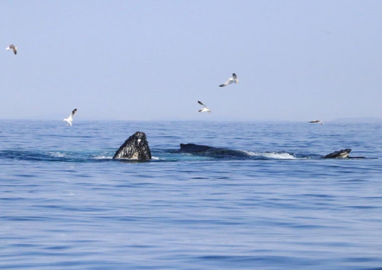
Research commissioned by the IWDG has identified a number of hotspots for dolphins, porpoise and whales within Ireland’s 12-nautical-mile limit.
These have informed the group’s recommendations for potential MPA sites around the coast, available on the IWDG website here.
Trinity Conference To Discuss Ireland’s ‘Poor Performance’ On Marine Protected Areas
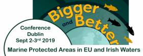
The global climate crisis and how it relates to biodiversity and ocean protection is a big topic for discussion at a two-day conference in Trinity College Dublin which starts tomorrow (Monday 2 September).
The ‘Bigger and Better’ Marine Protected Area Conference is co-hosted by Coastwatch Ireland and the Irish Wildlife Trust (IWT), who highlight that Ireland has protected only a fraction of its waters as pledged by 2020.
It will bring together Government officials with international speakers and experts to explore the reasons for Ireland’s “poor performance” when it comes to protecting our seas.
“Ireland is a laggard in providing the protections required to restore our ocean’s health,” said IWT campaign officer Pádraic Fogarty.
“MPAs [Marine Protected Areas] are now widely applied across the world as a tool in protecting biodiversity and ocean ecosystems.
“As an island nation we really should be at the forefront of this effort – not at the back of the class.”
‘Marine Protected Areas’ Call In Seanad Motion Today
#MarineWildlife - The Seanad today (Wednesday 23 May) is expected to hear a motion calling for the declaration of coastal areas around Ireland has ‘marine protected areas’ or MPAs.
According to The Irish Times, the motion is being tabled by Senator Grace O’Sullivan of the Green Party, who wants the Government to protect half of the waters around the country under “community-driven MPAs” with fishermen and conversationists alike at the heart of the process.
Senator O’Sullivan says a number of zones identified by the Marine Institute as particularly vulnerable to overfishing should be designated first.
Padraic Fogarty of the Irish Wildlife Trust, which supports the motion, suggests that most bays and estuaries around Ireland should be covered by the proposal.
The Irish Times has more on the story HERE.


 as lead helm, rounds the Fastnet Rock on the way to the overall win in 1987")


 Michael Murphy Schull Harbour Sailing Club (SHSC), Eric Coogan Heineken Ireland, Mark Murphy, Commodore SHSC, Jack Allen SHSC, Carmel O'Regan SHSC, Cornelious Ndlovu, Schull Harbour Hotel Operations Manager and Derval Murphy SHSC")
