Menu

Ireland's sailing, boating & maritime magazine

Displaying items by tag: Parteen weir

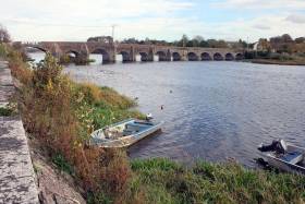
Waterways Ireland has closed the public footpath running south from O’Briensbridge playground alongside the River Shannon south of Parteen Weir for the foreseeable future, following the discovery of critical failures in two culverts under the path.

Preliminary investigations revealed the need for urgent replacement work on both culverts, the cross-border body for Ireland’s inland waterways says.

It adds that due to the sensitive habitat at the site on the Clare/Limerick border, planning permission is required before the works can go ahead, and this could take up to six months to come through.

“The health and safety risks associated with the two structures are such that it is essential the route is closed and remain so, until after the refurbishment works are completed,” it says.

“Waterways Ireland is aware that this is a popular route for the local community and apologises for any inconvenience caused by this closure.”

Published in Inland Waterways

Waterways Ireland has advised all users of the Shannon Navigation that remedial work to effect repairs to the infrastructure between Limerick City to Parteen Weir has been delayed and the navigation will not open this week as anticipated.

As Afloat.ie reported in May, the stretch of navigation was closed due to continuing high flow rates and infrastructural deficiencies as a result of the winter storms and subsequent flooding.

Published in Inland Waterways

Limerick's newly appointed Minister of State Patrick O'Donovan has been asked to intervene with Waterways Ireland to reopen navigation of the River Shannon at Limerick city and avoid the loss of marine tourism revenue to the city writes Andrew Carey.

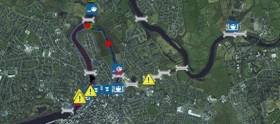
As Afloat.ie reported earlier, on April 25, Waterways Ireland issued a marine notice advising all users that the river from Limerick city to Parteen Weir would close to navigation.

It cited the "continuing high flow rates and infrastructural deficiencies as a result of the winter storms and subsequent flooding" as reasons for the closure.

Waterways Ireland said that the "floating breakwater at the entrance to the Abbey River in Limerick is no longer in place to protect vessels from striking the fixed weir. Also, there are many strong currents and eddies making navigation dangerous for both large and small craft.

A safety inspection of other damaged floating pontoons further upstream was to be carried out "when water levels and flows permit. Meanwhile, users are advised to stay clear of these until a further Marine Notice is issued on this matter."

Remedial works have yet to take place and the waterway remains closed to all marine traffic during the peak summer season.

Sailors from local sailing clubs wishing to access the Shannon now face the prospect of missing completions and events around the west coast and beyond as they can not pass through the navigation.

Last year, a six point plan to boost marine tourism on the Shannon and in Limerick was launched by then Education Minister Jan O'Sullivan.

The plans, drafted by Limerick marine enthusiasts to benefit local tourism, heritage and education, were submitted to Waterways Ireland.

Well-known boatman Pat Lysaght said that "Limerick is effectively landlocked and until these issues are rectified we will continue to lose out".

Calling for immediate intervention by Minister O'Donovan, who has responsibility for tourism and sport, Cllr Emmett O'Brien said the closure of the waterway "means no boats can sail from Limerick city to Killaloe. This may have a serious impact on local tourism and is contrary to all lip service being paid to Limerick being a riverside city.

"We need a clear and accurate response from Waterways Ireland and the Council why this has occurred and our local Minister for State for Tourism must intervene to ensure this navigation route does not remain closed."

Fianna Fáil Deputy Niall Collins said that it was of huge concern that "Limerick City is effectively closed off to marine tourism and this is having a detrimental impact on tourism across the Shannon region.

“I’m calling on Waterways Ireland to outline when the navigational hazards it has identified along the river will be addressed. We need to know the planned schedule of works and when the river will be reopened to marine traffic.

"We can’t have a situation whereby boats cannot sail up or down the River Shannon during the peak of the tourist season. This needs to be addressed without delay."

At the time of going to press, Limerick City Council and Minister O'Donovan had failed to respond to queries.

Waterways Ireland issued this statement on Wednesday afternoon.

"The stretch of navigation from Limerick city to Parteen Weir remains closed to navigation due to continuing infrastructural deficiencies as a result of the winter storms and subsequent flooding.

"Waterways Ireland, following the 2015/2016 flooding event has and continues to restore the infrastructure right along the Shannon navigation following on from the damage caused by record flood levels and the prolonged duration of these floods during last winter.

"However, Waterways Ireland has limited resources available to it and has had to prioritise its' interventions in those areas of greatest need and use."

The statement did not indicate any timeframe for reopening of the navigation.

Published in Inland Waterways

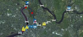
Waterways Ireland advises all users of the Shannon Navigation that the stretch of navigation from Limerick City to Parteen Weir is closed to navigation due to continuing high flow rates and infrastructural deficiencies as a result of the winter storms and subsequent flooding.

Users should note that the floating weir at the entrance to the Abbey River in Limerick is no longer in place to protect vessels from striking the fixed weir. Also, there are many strong currents and eddies making navigation dangerous for both large and small craft.

Floating pontoons have been damaged and are not suitable for mooring to or walking on, safety inspection of these will be carried out when water levels and flows permit. Meanwhile, users are advised to stay clear of these until a further Marine Notice is issued on this matter.

Published in Inland Waterways

About Dublin Port 

Dublin Port is Ireland’s largest and busiest port with approximately 17,000 vessel movements per year. As well as being the country’s largest port, Dublin Port has the highest rate of growth and, in the seven years to 2019, total cargo volumes grew by 36.1%.

The vision of Dublin Port Company is to have the required capacity to service the needs of its customers and the wider economy safely, efficiently and sustainably. Dublin Port will integrate with the City by enhancing the natural and built environments. The Port is being developed in line with Masterplan 2040.

Dublin Port Company is currently investing about €277 million on its Alexandra Basin Redevelopment (ABR), which is due to be complete by 2021. The redevelopment will improve the port's capacity for large ships by deepening and lengthening 3km of its 7km of berths. The ABR is part of a €1bn capital programme up to 2028, which will also include initial work on the Dublin Port’s MP2 Project - a major capital development project proposal for works within the existing port lands in the northeastern part of the port.

Dublin Port has also recently secured planning approval for the development of the next phase of its inland port near Dublin Airport. The latest stage of the inland port will include a site with the capacity to store more than 2,000 shipping containers and infrastructures such as an ESB substation, an office building and gantry crane.

Dublin Port Company recently submitted a planning application for a €320 million project that aims to provide significant additional capacity at the facility within the port in order to cope with increases in trade up to 2040. The scheme will see a new roll-on/roll-off jetty built to handle ferries of up to 240 metres in length, as well as the redevelopment of an oil berth into a deep-water container berth.

Dublin Port FAQ

Dublin was little more than a monastic settlement until the Norse invasion in the 8th and 9th centuries when they selected the Liffey Estuary as their point of entry to the country as it provided relatively easy access to the central plains of Ireland. Trading with England and Europe followed which required port facilities, so the development of Dublin Port is inextricably linked to the development of Dublin City, so it is fair to say the origins of the Port go back over one thousand years. As a result, the modern organisation Dublin Port has a long and remarkable history, dating back over 300 years from 1707.

The original Port of Dublin was situated upriver, a few miles from its current location near the modern Civic Offices at Wood Quay and close to Christchurch Cathedral. The Port remained close to that area until the new Custom House opened in the 1790s. In medieval times Dublin shipped cattle hides to Britain and the continent, and the returning ships carried wine, pottery and other goods.

510 acres. The modern Dublin Port is located either side of the River Liffey, out to its mouth. On the north side of the river, the central part (205 hectares or 510 acres) of the Port lies at the end of East Wall and North Wall, from Alexandra Quay.

Dublin Port Company is a State-owned commercial company responsible for operating and developing Dublin Port.

Dublin Port Company is a self-financing, and profitable private limited company wholly-owned by the State, whose business is to manage Dublin Port, Ireland's premier Port. Established as a corporate entity in 1997, Dublin Port Company is responsible for the management, control, operation and development of the Port.

Captain William Bligh (of Mutiny of the Bounty fame) was a visitor to Dublin in 1800, and his visit to the capital had a lasting effect on the Port. Bligh's study of the currents in Dublin Bay provided the basis for the construction of the North Wall. This undertaking led to the growth of Bull Island to its present size.

Yes. Dublin Port is the largest freight and passenger port in Ireland. It handles almost 50% of all trade in the Republic of Ireland.

All cargo handling activities being carried out by private sector companies operating in intensely competitive markets within the Port. Dublin Port Company provides world-class facilities, services, accommodation and lands in the harbour for ships, goods and passengers.

Eamonn O'Reilly is the Dublin Port Chief Executive.

Capt. Michael McKenna is the Dublin Port Harbour Master

In 2019, 1,949,229 people came through the Port.

In 2019, there were 158 cruise liner visits.

In 2019, 9.4 million gross tonnes of exports were handled by Dublin Port.

In 2019, there were 7,898 ship arrivals.

In 2019, there was a gross tonnage of 38.1 million.

In 2019, there were 559,506 tourist vehicles.

There were 98,897 lorries in 2019

Boats can navigate the River Liffey into Dublin by using the navigational guidelines. Find the guidelines on this page here.

VHF channel 12. Commercial vessels using Dublin Port or Dun Laoghaire Port typically have a qualified pilot or certified master with proven local knowledge on board. They "listen out" on VHF channel 12 when in Dublin Port's jurisdiction.

A Dublin Bay webcam showing the south of the Bay at Dun Laoghaire and a distant view of Dublin Port Shipping is here
Dublin Port is creating a distributed museum on its lands in Dublin City.
 A Liffey Tolka Project cycle and pedestrian way is the key to link the elements of this distributed museum together.  The distributed museum starts at the Diving Bell and, over the course of 6.3km, will give Dubliners a real sense of the City, the Port and the Bay.  For visitors, it will be a unique eye-opening stroll and vista through and alongside one of Europe’s busiest ports:  Diving Bell along Sir John Rogerson’s Quay over the Samuel Beckett Bridge, past the Scherzer Bridge and down the North Wall Quay campshire to Berth 18 - 1.2 km.   Liffey Tolka Project - Tree-lined pedestrian and cycle route between the River Liffey and the Tolka Estuary - 1.4 km with a 300-metre spur along Alexandra Road to The Pumphouse (to be completed by Q1 2021) and another 200 metres to The Flour Mill.   Tolka Estuary Greenway - Construction of Phase 1 (1.9 km) starts in December 2020 and will be completed by Spring 2022.  Phase 2 (1.3 km) will be delivered within the following five years.  The Pumphouse is a heritage zone being created as part of the Alexandra Basin Redevelopment Project.  The first phase of 1.6 acres will be completed in early 2021 and will include historical port equipment and buildings and a large open space for exhibitions and performances.  It will be expanded in a subsequent phase to incorporate the Victorian Graving Dock No. 1 which will be excavated and revealed. 
 The largest component of the distributed museum will be The Flour Mill.  This involves the redevelopment of the former Odlums Flour Mill on Alexandra Road based on a masterplan completed by Grafton Architects to provide a mix of port operational uses, a National Maritime Archive, two 300 seat performance venues, working and studio spaces for artists and exhibition spaces.   The Flour Mill will be developed in stages over the remaining twenty years of Masterplan 2040 alongside major port infrastructure projects.

Source: Dublin Port Company ©Afloat 2020.