


Displaying items by tag: wetlands
Ireland Marks World Wetlands Day With a Number of Events
World Wetlands Day is being marked in Ireland with a number of events on coastlines and inland lakes from February 1st to 3rd.
Birdwatch Ireland says that Ireland has an “incredible array” of wetlands, from coastal and inland areas to turloughs and peatlands, supporting an “abundance of life”.
“A diverse web of plants, invertebrates, reptiles, amphibians, fish, birds and mammals rely on these habitats for their survival and, as wetlands provide water and food, store floodwater, protect against extreme weather events, and capture carbon, there’s no doubt that we humans are dependent on them, too,” it says.
While wetlands are “birding hotspots year-round”, Birdwatch Ireland says, the numbers of birds surge at these wetlands each autumn with the arrival of migratory waterbirds.
These include many species of waders, ducks, geese and swans which breed in northern latitudes and migrate southwards to spend the winter. Wexford Harbour and Slobs welcome Greenland white-fronted geese in their thousands each October.
Galway Bay, Donegal Bay, Blacksod, and Tullaghan Bays are also internationally important sites for Great northern divers who migrate from North America, Greenland and Iceland to winter in Ireland.
Several events taking place from February 1st to 3rd are listed below:
World Wetlands Day event at Bull Island, February 3rd- free talk in Bull Island’s Interpretive Centre at 11am, followed by birdwatching on the island afterwards. All are welcome! This event is hosted by BirdWatch Ireland and Dublin City Council.
Birdwatching at the Boyne Estuary - The BirdWatch Ireland Meath Branch will hold an event on Saturday, February 3rd from 2pm until 4pm, when participants can enjoy a guided walk with Birdwatch Ireland Meath’s Franck Le Moenner around the Boyne estuary in Mornington. This event is held in association with Meath County Council. Find out more and RSVP here.
World Wetlands Day Workshop in Limerick - A World Wetlands Day Workshop organised by Limerick City and County Council will be held on Thursday, February 1st, with Tom Tarpey from the BirdWatch Ireland Limerick Branch as one of the three main speakers. The event will run from 7 p.m. until 9.30 p.m., with Tom giving a talk on wetland birds and wintering wildfowl at 7.30 p.m. Find out more and RSVP here.
Tralee Bay Wetlands and Lough Gur Lakeshore Among Green Flag Award Winners
Kerry’s Tralee Bay wetlands and Lough Gur lakeshore in Co Limerick are both winners in this year’s Green Flag awards.
Some 101 green spaces were selected for awards in Ireland out of a total of 150 across Europe, according to An Taisce’s environmental education unit.
Tralee Bay Wetlands Eco and activity park was the overall winner, and also the town winner in the Green Flag Pollinator awards.
Lough Gur Lakeshore Park and Visitor Centre in Limerick was one of two, along with Julianstown Community Garden in Co Meath, to receive special innovation awards.
Lough Gur installed 28 bee lodges to support solitary and native bees. The lodges were built by participants in the Probation and Linkage in Limerick scheme as part of the prison education programme, and were funded by Analog Devices.
 An Taisce's Green Flag flying at Lough Gur Lakeshore Park and Visitor Centre in Limerick
Other coastal award winners include Garinish Island and Fota Arboretum and Gardens in Co Cork and Derrynane House and Park in Co Kerry.
Participating countries in the international award scheme are Austria, Belgium, Finland, France, Germany, Ireland, the Netherlands, Portugal, Spain, Sweden and Turkey.
Britain, where the green flag was initiated in 1996, is no longer in the EU but has 2,216 parks – the largest number since the scheme began 27 years ago – which can raise green flags this year.
Like its blue flag counterpart on coastlines, the green flag award benchmarks excellence in the management of spaces which are open and free to the public. In this case, it highlights parks, gardens, grounds and wildlife sanctuaries which have made special efforts.
An Taisce’s environmental education unit published the full list here
Ireland's Wetlands and Why We Should Care - Tobias Salathé of the UN Ramsar Convention
Ireland has 45 fragile flooded habitats which are protected under a UN Convention named after a city on the Caspian Sea.
The Ramsar Convention was signed in the city in 1971, and international participation has gradually grown to 172 countries.
Ireland has 45 such designated areas under the convention in bogs, marshes, ponds and lakes, rivers, wet woodlands/grasslands, fens, estuaries and coastal lagoons.
 Booterstown Nature Reserve on Dublin Bay is a unique home to many protected species Photo: Wikicommons
“Time to restore” was the theme of this year’s UN World Wetlands Day, and Tobias Salathé, senior advisor to the UN Ramsar Convention, marked it at an event in Wexford hosted by Coastwatch Ireland.
Afterwards, Salathé and Coastwatch’s Karin Dubsky spoke to Wavelengths at Booterstown Marsh in Dublin. Salathé, an ornithologist, explained what the convention is all about and why we should care, and we began with Karin Dubsky explaining what we were all looking at.
World Wetlands Day To Be Marked By Coastwatch in Wexford
Restoration is the theme of a Coastwatch event to mark UN World Wetlands Day today in Co Wexford.
The one-day event will include a keynote address by Tobias Salathe of the Ramsar Convention European office in Geneva, Switzerland.
Ireland currently has 45 areas designated as Ramsar sites or wetlands of international importance, covering a surface of 66,994 hectares.
They are protected by the Convention on Wetlands, which came into force here in March,1985.
The convention is an intergovernmental treaty that provides the framework for national action and international cooperation for the conservation and wise use of wetlands and their resources.
Ireland is one of 172 contracting parties to the convention protecting 2,400 wetlands of international importance.
The total surface of designated sites extends across a global area of 256,192,356 hectares.
Austrian ambassador to Ireland HE Thomas Nader will open a Coastwatch exhibition this morning in Wexford County Hall at 11am, followed by Mr Salathe’s address.
A workshop on addressing climate change, biodiversity and water quality issues and the role of wetlands will be facilitated by journalist Brian Trench.
Field trips are planned to wetlands both threatened by climate change, including farmland which was claimed from the sea years ago and is now in the front line of sea level rise and storm surges, according to Coastwatch co-ordinator Karin Dubsky.
The event will conclude with a celebration in “song, music and word” from 5pm to 7pm. More here
Tribute Paid by Minister to Communities on World Wetlands Day
World Wetlands Day 2022 has been marked by Minister of State for Heritage Malcolm Noonan with a tribute to communities who have worked to restore and raise awareness of the value of wetlands and peatlands.
Community-led projects are a key component to the conservation and restoration of wetlands, he said.
Mr Noonan has also released a promotional video to “raise public awareness of the value of peatlands as key ecosystems”.
Such wetlands and peatlands provide “socio-economic and environmental benefits as well as being large, long-term carbon stores with unique biodiversity”, he noted.
 Minister of State for Heritage Malcolm Noonan
“Since 2018, with increased funding and resources, the National Parks and Wildlife Service of the Department of Housing, Local Government and Heritage has restored or is actively restoring over 5,000 ha of protected raised bogs,”he said.
“This year will see the conclusion of the LIFE ‘Living Bog’ project which restored 12 raised bogs designated as Natura 2000 sites (SACs) in the midlands region,” he said.
A community engagement scheme run by his department has the largest funding allocation to date of 50,000 euro this year, Noonan said.
He has also announced that his department’s Local Biodiversity Action Fund is now open to applications from local authorities.
The fund increased to €1.5m in 2022, and supports locally-led projects that align with actions under the National Biodiversity Action Plan, he said.
One such project funded under the scheme in 2021 is Galway County Council’s “Wetlands of North East Galway” StoryMap, which has also been published this week.
The scheme, operated by the National Parks and Wildlife Service has “proven hugely popular, with all 31 local authorities seeking funding in 2021”, he said.
“A wide variety of projects were financed, ranging from the surveying of breeding birds and the creation of pollinator-friendly initiatives to projects raising awareness of the importance of biodiversity to our well-being, he said.
World Wetlands Day Marked in Ireland With Photo Contest
They might be small pockets of marshy ground, or they could be on bogs, in estuaries, or turloughs.
All these are wetland habitats, and are the focus of a new photographic contest to mark World Wetlands day today, February 2nd.
The global event marks 50 years since the signing of the Ramsar Convention, an international agreement on conservation and “wise use” of wetlands.
Ireland is a signatory to the agreement which aims to ensure protection of the ecosystems which tend to be taken for granted.
The Irish Ramsar Wetlands Committee says that a combination of geology and abundant rain has “endowed Ireland with an extraordinary array of wetlands covering some 20% of the country”
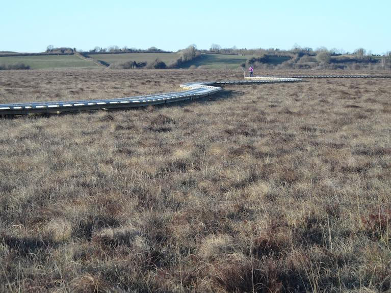
 The Clara Bog Ramsar site Photo: Peter Foss of Wetland Surveys Ireland
“There are many types of wetlands ranging from lakes, rivers, turloughs, bogs and estuaries to fens, marshes, wet woodlands, heaths and machair,” it says.
“While many wetlands are protected under EU environmental legislation, 45 of Ireland’s wetlands are Ramsar sites,” it says, and are part of the global Ramsar network.
These sites include Tralee Bay, Lough Corrib, Pollardstown Fen, Clara Bog and Coole Lough and Garryland wood.
Irelands Ramsar sites are important for their variety of wetlands habitats, for wintering and breeding birds and for plants, mammals and invertebrates.
Some 40% of all species live or breed in wetlands, and wetlands store 30% of land-based carbon which is vital for climate change mitigation.
The ecosystems also remove pollutants from circulation and provide protection from flooding and storms.
A video series is being rolled out today, launched by EcoEye presenter Anja Murray, with more details on Irish wetlands.ie
Photos of wetland habitats can be submitted via the Wetland Surveys Ireland Snapshot App until May 31st.
Prizes include OPW Family Heritage Cards, Biodiversity Ireland Swatch cards and inclusion in a 2022 Irish Wetlands Calendar.
Coastwatch Warns Over Draining of Cork Wetlands
Ballyvergan marsh is under threat after the discovery of an illegal pipe being used to drain the wetlands area, claims Coastwatch.
The Irish Times reports that the environmental group has called for immediate action over the draining of the marsh near Youghal in Co Cork.
Cork County Council has also confirmed to the paper that a letter regarding an "allegation of unathorised development" has been sent to the landowner.
The marsh at Ballyvergan is one of the largest on the south coast, and is zoned as a special amenity. It is also an important breeding site for migratory birds.
Karin Dubsky of Coastwatch said that the situation highlights the deficiencies in State policy regarding Ireland's wetlands.
The Irish Times has more on the story HERE.


, marking also a first presence in this market.")
 Michael Murphy Schull Harbour Sailing Club (SHSC), Eric Coogan Heineken Ireland, Mark Murphy, Commodore SHSC, Jack Allen SHSC, Carmel O'Regan SHSC, Cornelious Ndlovu, Schull Harbour Hotel Operations Manager and Derval Murphy SHSC")

 at Dublin when bound for Holyhead; such high-speed craft 'seasonal’ services resume next month")


