


Displaying items by tag: Marine Institute
2018 Anglerfish & Megrim Survey Begins Today
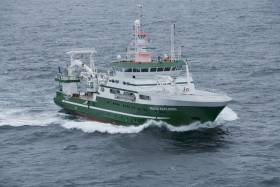
#MarineNotice - The Marine Institute’s annual Irish Anglerfish and Megrim Survey (IAMS) for 2018 is scheduled to resume today, Tuesday 10 April.
After January's survey off the West and South Coasts, this month's survey will be carried out till Saturday 21 April off the North and North West Coasts of Ireland in fulfilment of Ireland’s Common Fisheries Policy obligations.
The IAMS is a demersal trawl survey consisting of approximately 50 otter trawls of 60 minutes duration in ICES area 6a. Fishing will take place within a three nautical mile radius of the positions indicated in Marine Notice No 15 of 2018, a PDF of which is available to read or download HERE.
Survey operations will be conducted by the RV Celtic Explorer (Callsign EIGB), which will display all appropriate lights and signals during the survey and will also be listening on VHF Channel 16.
The vessel will be towing a Jackson demersal trawl during fishing operations. The Marine Institute requests that commercial fishing and other marine operators keep a three nautical mile area around the tow points clear of any gear or apparatus during the survey period outlined above.
Specifics of any fishing gear or other obstructions that are known and cannot be kept clear of these survey haul locations can be notified using the contact details provided in the Marine Notice.
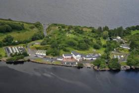
The Marine Institute’s Research Facility in Furnace, Newport, Co Mayo will open its doors on Saturday 14 April from 11am to 4pm.
The open day is for all, and visitors will have the opportunity to view the facility for studying migratory fish, located in the Burrishoole Valley.
Visitors will be able to learn more about the history of the facility and the marine science projects taking place at the site.
They will also have the opportunity to speak with researchers, scientists and staff at the Newport facility. A number of PhD candidates will be available to talk to students about their subject choices and potential careers in the marine sector.
Visitors can look through microscopes to see freshwater invertebrates, view fish species up-close in the aquarium displays and learn how to read a salmon scale.
There’s also the chance to visit the manual climate station and see the instruments used to collect daily data for Met Éireann.
The Marine Institute describes its facility in Newport as “a unique research centre” where a range of research is undertaken, including genetics work across several species of salmon, sea bass, pollock and bluefin tuna, as well as studies on catchment ecosystems events, climate change, oceanography and aquaculture.
The facility, which has been in operation since 1955, includes laboratories, a freshwater hatchery, fish rearing facilities, fish census trapping stations, a salmonid angling fishery and a monitored freshwater lake and river catchment.
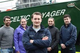
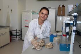
#MarineScience - A new survey sampling Nephrops larvae from the area west of the Aran Islands is currently being conducted for the first time aboard the RV Celtic Voyager.
“Nephrops are more commonly known as Dublin Bay prawn, Norway lobster or scampi, and are the most valuable demersal fishery in Ireland,” said Ryan McGeady, PhD candidate at NUI Galway and chief scientist on the two-week mission which began on Tuesday 3 April.
“The value of Nephrops of landings by Irish vessels was €60 million, the stocks around Ireland that the Marine Institute assess with the underwater TV surveys is more than €100 million.”
Nephrops are widely distributed in Irish waters, found in the Irish Sea, the Celtic Sea and off the West Coast of Ireland. They spend a great deal of time in their burrows found in areas of muddy sediment at the bottom of the ocean only coming out for food or mating purposes.
Unlike fish, Nephrops cannot be aged directly. Coupled with their complex biology and behaviour, stock assessment of Nephrops is notoriously difficult to assess.
Since 2002, the Marine Institute has been using underwater television surveys to independently estimate abundance, distribution and stock sizes on the Aran Grounds, Western Irish Sea and the Celtic Sea.
However, the primary focus of this survey is to collect data on the distribution of Nephrops larvae from two commercially important grounds, including off the West Coast and the Irish Sea.
Female Nephrops mature at three years of age, when they start to reproduce each year. After mating in early summer, they spawn in September, and carry eggs under their tails until they hatch in April or May. The Nephrops larvae develop in the plankton before settling to the seabed nearly two months later.
“The importance of this survey is that it is multi-disciplinary which allows us to use both oceanographic data and biological sampling to increase our knowledge on what influences larval distribution and retention on mud patches where the species lives,” Dr Colm Lordan of the Marine Institute said.
The data collected will be used to improve the accuracy of computer models that simulate the movement of Nephrop larvae in the ocean. The information gathered during the survey will also be used to validate or ‘ground-truth’ the model to ensure its accuracy.
“It is hoped that an improved model can be used to estimate the proportion of larvae surviving to adulthood each year. This will make it easier to estimate the health of the stock,” said Dr Anne Marie Power of NUI Galway.
Acoustic records of pelagic fish shoals will also be collected to compare with characteristics of the environment. Observations will be carried out to examine the effect of trawling on fish aggregations once gear has passed through.
Fish shoal sampling will contribute towards an IRC-funded project that will use models of mackerel collective behaviour to improve traditional fisheries assessments and provide a framework for using shoals as an indicator of population health.
Oceanographic data collection will feature hyper-spectral light measurements to assist in the validation efforts of Irish satellites. This will support a Marine Institute Cullen Fellow examining space-based observations of marine phytoplankton in Northeast Atlantic surface water masses and potential environmental monitoring applications.
The team of scientists supporting Cullen Fellow Ryan McGeady board the RV Celtic Voyager includes Darragh Furey (Galway); Sophia Wasserman (Maryland, USA; IRC postgraduate scholar); Catherine Jordan (Mayo; Marine Institute Cullen Fellow/ NUIGalway); and Leigh Barnwall (Dublin). Dr Anne Marie Power Dr Colm Lordan are providing base support for this research.
This research survey is carried out with the support of the Marine Institute, funded under the Marine Research Programme 2014-2020 by the Irish Government.

Shellfish landings — particularly brown crab and whelk — saw a significant boom in 2016 compared to previous years, with a value of €56 million to the economy.
But species such as lobster and periwinkle saw “unexpected changes in volumes” compared to 2004 levels, according to the Marine Institute’s Shellfish Stocks and Fisheries Review for 2016-2017.
“Although landings can obviously increase or decline due to changes in fishing effort or catch rates, the scale of change in some species, in fisheries that are known to have stable or increasing effort and where catch rate indicators are stable, is contradictory,” the report warns.
“Other sources of information from industry questionnaires also indicate significant differences between official landings and landings derived from estimates of catch rates, annual individual vessel landings, days at sea and individual vessel fishing effort.”
The review concentrates on cockles, oysters, scallops, lobsters and razor clams, of which the North Irish Sea fishery for the latter saw significant expansion between 2011 and 2017, in tandem with a decline in stock.
Earlier this year, consultations were held on proposals for new conservation measures to protect razor clams in the North Irish Sea and brown crab in Irish waters, as previously reported on Afloat.ie.
As for cockles, the main fishery in Dundalk Bay experiences variable rates of overwinter survival, resulting in a biomass that in some years “is insufficient to support a fishery”. The situation is even more serious in the Waterford Estuary.
“Continuing commercial fisheries for cockles in Natura 2000 sites [like Dundalk Bay] will depend on favourable conservation status of designated environmental features that may be affected by this fishing activity or a clear demonstration that changes to designated features are not due to cockle fishing,” the review states.
Oyster stocks, meanwhile, are “generally low in all areas, except Fenit”, prompting a need for “management measures to restore recruitment and re-build spawning stocks”.
The full review is available to download from the Marine Institute website HERE.
Celtic Voyager Explores Irish Sea’s Lost landscapes

#MarineScience - An Irish research team from IT Sligo and University College Cork recently joined the ‘Europe’s Lost Frontiers’ project to explore the extensive submerged landscapes in the Irish Sea aboard the Marine Institute’s Celtic Voyager research vessel research vessel.
Following the last Ice Age, large areas of habitable land were inundated following climate change and sea level rise across the world. Globally, the sea level rose around 120 metres and an area more than twice that of the modern United States of America was lost to the sea.
Beneath the waves of the Irish Sea is a prehistoric ‘palaeolandscape’ of plains, hills, marshlands and river valleys in which evidence of human activity is expected to be preserved.
This landscape is similar to Doggerland, an area of the southern North Sea and currently the best known example of a palaeolandscape in Europe. Doggerland has been extensively researched by Prof Vince Gaffney, principal investigator of the Europe’s Lost Frontiers project.
“Research by the project team has also provided accurate maps for the submerged lands that lie between Ireland and Britain,” said Prof Gaffney, “and these are suspected to hold crucial information regarding the first settlers of Ireland and adjacent lands along the Atlantic corridor.”
To provide this evidence, sediment from some 60 cores, taken from 20 sites by the RV Celtic Voyager in Liverpool and Cardigan Bays between the 21 and 25 February, will be studied by an international marine research team.
Dr James Bonsall, from the Centre for Environmental Research Innovation and Sustainability (CERIS) in the Department of Environmental Science at IT Sligo, was chief scientist for this phase of the research, and together with his CERIS colleague, environmental scientist Eithne Davis, directed operations on board the RV Celtic Voyager.
“It is very exciting,” said Dr Bonsall, “as we’re using cutting-edge technology to retrieve the first evidence for life within landscapes that were inundated by rising sea levels thousands of years ago.
“This is the first time that this range of techniques has been employed on submerged landscapes under the Irish Sea. Today we perceive the Irish Sea as a large body of water, a sea that separates us from Britain and mainland Europe, a sea that gives us an identity as a proud island nation. But 18,000 years ago, Ireland, Britain and Europe were part of a single landmass that gradually flooded over thousands of years, forming the islands that we know today.
“We’re going to find out where, when, why and how people lived on a landscape that today is located beneath the waves.”
Key outcomes of the research will be to reconstruct and simulate the palaeo-environments of the Irish Sea, using ancient DNA, analysed in the laboratories at the University of Warwick, and palaeo-environmental data extracted from the sediment cores.
The studies will be of immense value in understanding ‘first’ or ‘early’ contact and settlement around the coasts of Ireland and Britain, but also the lifestyles of those people who lived within the inundated, prehistoric landscapes that lie between our islands and which have never been adequately explored by archaeologists.
The Celtic Voyager and the Marine Institute’s expertise were provided to explore the extensive submerged landscapes, where marine core samples were taken. Technical support setting up the seabed survey and navigation systems was also provided by members of the DCCAE-funded INFOMAR team, who specialise in bathymetric mapping and geophysical survey.
This research survey was carried out with the support of the Marine Institute, funded under the Marine Research Programme 2014-2020 by the Irish Government.
Europe’s Lost Frontiers is an ERC-funded Advanced Grant project based at the University of Bradford. Aimed at understanding the transition between hunter gathering to farming in north-west Europe, the project is studying the evidence for inundated palaeolandscapes around the British coast using seismic reflectance data sets to generate topographical maps of these ‘lost lands’ that are as accurate and complete as possible.
Environmental data from these areas is then being used to reconstruct and simulate the palaeo-environments of these landscapes using ancient DNA extracted directly from sediment cores as well as traditional environmental evidence.
RV Celtic Voyager To Be Replaced As Part Of National Development Plan
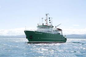
#MarineScience - The Government’s new National Development Plan includes provision for a new marine research vessel to replace the RV Celtic Voyager, according to The Irish Times.
Marine Institute chief executive Dr Peter Heffernan says work is at an “advanced stage” towards confirmation of the project, which would see the 31-metre Celtic Voyager — which has served for two decades — replaced with a vessel of around 50 metres in length.
The new ship would serve alongside the RV Celtic Explorer, which recently underwent a major refit, as previously reported on Afloat.ie.
Refit of RV Celtic Explorer Leads to a Renewed Start in 2018
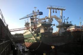
#MarineScience - Research vessel RV Celtic Explorer of the Marine Institute, is off to a renewed start in 2018, after undergoing a major refit.
The Romanian-Dutch built ship is ready to accommodate 18 scientific surveys throughout the year.
The five-year refit included an overhaul of the bow thruster and an upgrade of its DC propulsion system. The vessel's original fishing sonar was removed and a new Simrad SU92 fisheries sonar installed. The new sonar will have an increased range and resolution and a decreased noise level, which will be a huge advantage for the Marine Institute's fisheries research.
The vessel's accommodation also received an upgrade after 15 years of service with cabin floors refurbished and a new accommodation layout in the scientists cabins. The RV Celtic Explorer's refit also included painting and antifouling of the hull and complete painting of the superstructure as well as a major 60,000 hour overhaul of one of its main diesel generators .
The 65.5m vessel was in A&P yard in Falmouth, United Kingdom for the refit which started in mid in December 2017 and works were completed this month.
The RV Celtic Explorer came into service in 2003 and is designed for fisheries acoustic research, oceanographic, hydrographic and geological investigations as well as buoy/deep water mooring and ROV Operations.
Several deepwater ROV surveys will be undertaken in 2018, one led by Dr Louise Allcock from the National University of Ireland, Galway will investigate deep sea corals and sponges from a diversity of deep-water habitats.
Professor Andrew Wheeler from the University College Cork will explore and monitor cold water corals in the submarine canyons in the deep ocean and determine their sensitivity to climate change, fisheries and oil industry impacts.
A survey led by Professor Sergei Lebedev from the Dublin Institute for Advanced Studies will investigate the structure, evolution and seismic hazard of Ireland's offshore territory. Professor Lebedev's team will for the first time, deploy an array of ocean-bottom, broadband seismometers offshore, which together with existing arrays onshore will cover the entire Irish territory.
Dr Aggeliki Georgiopoulou from the University College Dublin will survey the structure and composition of the lower crust and mantle, as well as any hydrothermal activity RV Celtic Explorer off to a renewed start in 2018 at the Charlie Gibbs Fracture Zone, the largest geological fault in the northern Mid-Atlantic Range.
In 2018 the Marine Institute will also undertake acoustic surveys of Anglerfish and Megrim, Blue Whiting, Celtic Sea Herring and Boarfish on the RV Celtic Explorer. An INFOMAR-led survey will also map the physical features of the seabed in the Celtic Sea, using hydrographic techniques.
To follow the voyages of the RV Celtic Explorer, visit the Marine Institute website to track a vessel or view the vessel schedule. A virtual tour of the RV Celtic Explorer can also be accessed from the Marine Institute website at www.marine.ie
Irish Scientist Appointed Vice Chair Of International Council for the Exploration of the Sea’s Advisory Committee
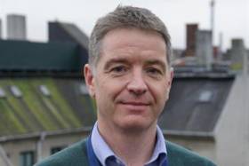
#MarineScience - Dr Colm Lordan of Fisheries Ecosystems Advisory Services at the Marine Institute has been appointed as one of the Vice Chairs of the International Council for the Exploration of the Sea (ICES) Advisory Committee.
The ICES Advisory Committee (ACOM) is responsible for providing scientific advice to competent authorities in support of the sustainable management of marine resources and ecosystems in the North Atlantic Ocean. Dr Lordan will work 50% of the time in his new ACOM role and 50% in his team lead role at the Marine Institute.
Dr Lordan joined the Marine Institute in 1998 and participated in Northern Shelf and Southern Shelf demersal stock assessment working groups.
In 2003, his focus moved to nephrops stocks and developing underwater television surveys and assessment methods. Dr Lordan currently leads a team of marine scientists working on demersal fish and nephrops surveys, stock assessment and scientific advice.
Dr Lordan said he is expecting his three-year term as Vice Chair of the ICES Advisory Committee to be both busy and diverse.
“I am looking forward to getting a broader perspective on the advisory system and I hope to learn a lot about stocks, fisheries, assessments, and management challenges in areas beyond the Celtic Seas,” he said.
“I am also interested in collaborating with others to improve the quality assurance and to develop new and innovative advisory products.”
Dr Lordan was first involved with ICES in 1993, and since then has participated in 60 different ICES expert groups and chaired or co-chaired 16 working groups.
ICES has a network of more than 5,000 scientists from over 690 marine institutes in 20 countries. For more information on ICES visit www.ices.dk.
Marine Institute Summer Bursary Scholarship Scheme Opens For 2018
#MarineScience - The Marine Institute is inviting marine science students to apply for a number of work experience placements for summer 2018.
The Marine Institute Bursary Scholarship Scheme provides scholarships worth €275 per week for an eight-to-12-week placement (bursary dependant).
Scholarship recipients will be based in various locations including the Marine Institute HQ in Oranmore, Co Galway; Newport, Co Mayo and other locations and ports around the country.
The Bursary Scholarship Scheme provides valuable practical experience for students in areas of research such as marine fisheries, salmon management, aquaculture, oceanography, benthic ecology, communications and R&D.
The programme is aimed at undergraduates of universities, institutes of technology and national institutes for higher education, and is strictly limited to those who will have completed two years’ study in a relevant discipline by the beginning of June.
Previous bursars have gone on to work in the Marine Institute (including two directors of the institute), Bord Iasaigh Mhara, Regional Fisheries Boards, county councils, pharmaceutical companies and State laboratories, with some going as far afield as the EPA in Sydney, Australia and others now running their own companies.
To apply for the Marine Institute Summer Bursary Programme for 2018:
- Check out the bursary titles on offer
- Select the two bursaries that interest you most and in order of preference
- Complete the application form and return it FAO Annette Jordan, Marine Institute, Furnace, Newport, Co Mayo
The deadline for applications is Friday 9 February.
Connemara Sea Scouts Solve Mystery Of Marine Research Buoy
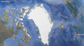
#ArcticBuoy - A marine research buoy found on the Connemara coast by local Sea Scouts recently had drifted over 6,000 kilometres across the Beaufort Sea, Arctic Ocean and Atlantic to Ireland.
The buoy, around half a metre in diameter, was found at Lettermullen by the scout troop during an exploration of their local beach.
Michael Loftus, leader of Gasógaí Mara na Gaeltachta (Connemara Sea Scouts), said they often find flotsam and jetsam washed up on the shore, which they can usually identify.
“However, little did we know that this new find would uncover a world of discovery relating to the buoy being launched from an aircraft in the Arctic Ocean and travelling thousands of kilometres to land on the west coast of Ireland.”
The Marine Institute, which works on a series of projects where autonomous instruments are deployed into the ocean for marine research, was contacted to help solve the mystery of where the red buoy came from.
“Although the buoy is not an Argo float that is typically used by the institute as part of the national Argo float programme, we were delighted to help the Sea Scouts establish that the buoy is in fact an Airborne Expendable Ice Buoy, which came from as far away as the Beaufort Sea,” said Diarmuid Ó Conchubhair of the Marine Institute.
The International Arctic Buoy Programme involves a number of different countries including Canada, China, France, Germany, Japan, Norway, Russia, and the United States.
The programme maintains a network of drifting buoys in the Arctic Ocean that are used to monitor sea surface temperatures, ice concentration, and sea level and support weather forecasting. The buoys are also used for validating climate or earth system models which inform the Intergovernmental Panel on Climate Change (IPCC) reports.
Each buoy in this programme has an identification number that is used to track its location in the Arctic Ocean using a type of satellite communication system.
“Using the number marked on this buoy [#4800512], we were able to establish that this particular buoy had been deployed by an aircraft over five years ago in the Beaufort Sea, north of the Yukon and Alaska, west of Canadian Arctic islands,” said Ó Conchubhair.
Dr Eleanor O’Rourke, oceanographic services manager at the Marine Institute, explained: “Researchers involved in the International Arctic Buoy Programme decide where to deploy buoys, particularly where the status of sea-ice may be changing.
“Most of the buoys are placed on sea ice, but some are placed in open water in some of the most remote parts of the world's ocean, where it is difficult for research vessels to access.”
Airborne Expendable Ice Buoys have an average lifespan of 18 months and around 25 to 40 buoys operate at any given time.
“The buoy last reported its data in 2014 and it is likely that it ran out of battery power and spent the last three to four years at the sea surface travelling via wind and ocean surface currents,” said O’Rourke.
In 2007, Ireland became a member of the international Argo programme, which uses robotic instruments known as autonomous Argo floats that report on subsurface ocean water properties such as temperature and salinity via satellite transmission to data centres.
Using a fleet of around 4,000 autonomous floats around the world, the Argo array is an indispensable component of the Global Ocean Observing System (GOOS).
“Similar to the buoys used by the International Arctic Buoy Programme, Argo floats collect and distribute real time information on the temperature and salinity of the ocean,” said Ó Conchubhair, who is vice chair of the European Argo Programme.
“Argo floats; however, measure these variables from the upper 2,000m of the ocean and help to describe long-term trends in ocean parameters such as their physical and thermodynamic state.”
This information is required to understand and monitor the role of the ocean in the Earth's climate system, in particular the heat and water balance.
Click here for more information about Ireland’s involvement in the Argo programme. You can also track and look at data from Irish Argo floats at Ireland’s Digital Ocean.
Four years ago, another Arctic device was found on the North West Coast and exhibited by Transition Year students in Co Mayo, as previously reported on Afloat.ie.


 as lead helm, rounds the Fastnet Rock on the way to the overall win in 1987")
