


Displaying items by tag: Marine Notice
Sailors Beware Of ROV Visual Survey Off South West Coast
#MarineNotice - Sailors and other mariners off the South West Coast should keep on the lookout for a visual survey by remote operated vehicle currently being undertaken by PSE Kindle Energy Ltd.
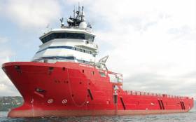
The survey, which was set to commence on Tuesday 9 May, will run for the next three weeks in the environs of the Kinsale Head Gas Field, subject to weather conditions, and is being carried out from the Skandi Olympia (Callsign C6XY8).
The vessel will have an ROV deployed close to the seabed and its travel rate (survey rate) is approximately 0.4 knots over the ground on a weather-dependent heading.
Regular safety messages will be broadcast on VHF Channel 16. All vessels, and particularly those engaged in fishing, are requested to give the Skandi Olympia a wide berth and keep a sharp lookout in the revenant areas, as detailed in Marine Notice No 19 of 2017, a PDF of which is available to read or download HERE.
In case of any doubt, call the vessel on VHF and a safe course to follow will be given.
Seismic Survey Under Way In Porcupine Basin Till July
#MarineNotice - Geoscience company CGG is currently conducting a 3D seismic survey off the South West Coast of Ireland in the Porcupine Basin.
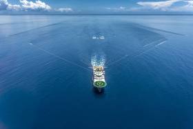
The three-month survey was scheduled to begin on Tuesday 11 April and will continue till Saturday 15 July. The vessels involved will be the Geo Coral (Callsign LACA8), Bourbon Tern (Callsign 5BDQ4), Marianne G (Callsign 3FTA9) and Stormbas 2 (Callsign V4EM2).
The Geo Coral is towing a multi-sensor streamer including 14 streamers with a 100m separation of an 8km length and a depth of 12 metres.
Yellow tail buoys will be towed at the end of each streamer, approximately 8.7km (4.7nm) behind the Geo Coral. Each tail buoy will have a light flashing Morse code 'U' with an interval of approximately 7 seconds.
There will be regular safety message broadcasting on VHF Channel 16 by the Geo Coral and accompanying vessels Marianne G and Stormbas 2 throughout the project. Seismic activity will be protected by support and chase vessels.
All vessels, particularly those engaged in fishing, are requested to give the Geo Coral and the towed equipment a wide berth and keep a sharp lookout in the relevant areas. In case of any doubt, call the Geo Coral on VHF Channel 16 and a safe course to follow will be given.
Full details of co-ordinates for the survey area are included in Marine Notice No 13 of 2017, a PDF of which is available to read or download HERE.

#Fishing - The Marine Institute will begin the annual Irish Anglerfish and Megrim Survey (IAMS 2017) off the North and North West Coasts from tomorrow (Saturday 8 June).
The 10-day operation, in fulfilment of Ireland’s Common Fisheries Policy (CFP) obligations, is a demersal trawl survey consisting of approximately 49 otter trawls (60 minutes) in ICES area 6a off Donegal – following on from a similar operation off the South Coast last month.
Fishing will take place within a three nautical mile radius of the positions indicated in Marine Notice 18 of 2017, a PDF of which is available to read or download HERE.
The RV Celtic Explorer (Callsign EIGB) will be used throughout the duration of the survey. The vessel will be towing a Jackson demersal trawl during fishing operations, will display appropriate lights and signals, and will be listening on VHF Channel 16 throughout.
Commercial fishing and other marine operators are requested to keep a 3nm area around the tow points clear of any gear or apparatus during the survey period.
Full co-ordinates of the survey area, as well as details for fishing operators with static gear within the survey zone, are included in the aforementioned Marine Notice.

#MarineNotice - PSE Kinsale Energy Limited will undertake a seabed survey off the South Coast of Ireland later this month.
The survey is to confirm the seabed status adjacent to subsea gas production infrastructure such as wellheads, manifolds, pipelines and umbilicals, collecting samples for analysis and undertaking multi-beam mapping of the seabed at select locations.
This survey, which forms part of ongoing field maintenance operations and provides information for future planning, is expected to commence on Thursday 13 April and last for approximately five to six days, subject to weather conditions.
The RV Celtic Voyager (Callsign EIQN) is scheduled to carry out the survey operations, which will take a number of seabed grab samples using a Van Veen Grab at predetermined locations, and will conduct multi-beam mapping of specific locations to assess the status of the subsea infrastructure in relation to the adjacent seabed.
A total of 31 seabed sampling stations and 15 multi-beam mapping locations are anticipated.
There will be a regular safety message broadcasting on VHF Channel 16 throughout the project. All vessels, particularly those engaged in fishing, are requested to give the RV Celtic Voyager a wide berth and keep a sharp lookout in the relevant areas.
Maps and co-ordinates of the survey areas are included in Marine Notice No 17 of 2017, available as a PDF to read or download HERE.
Bag-Nets & Sentinel Cages Deployed At Killary Harbour
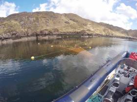
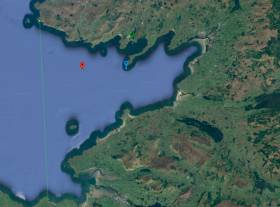
#MarineNotice - Inland Fisheries Ireland (IFI) will be carrying out scientific sampling using bag-nets and sentinel cages in Killary Harbour and surrounding waters from this week.
The bag-nets will start at the shore and extend into the water approximately 25 metres. The sentinel cages (nets) will be anchored near-shore and will not interfere with navigable waters.
All nets will be clearly marked with brightly coloured buoys with IFI identification so that any unintentional retrieval can be notified to IFI through the contact details provided.
Deployment operations will be carried out using an IFI RIB, Sea Breeze (Callsign EI-5724; MMSI 250002937), and will take place today Monday 3 April, subject to weather conditions. The nets will be checked daily (weather dependent) and all sampling nets and buoys will be retrieved on Friday 2 June.
A map and co-ordinates of the relevant locations are included in Marine Notice No 16 of 2017, a PDF of which is available to read or download HERE.
Drinking & Boating? Think Again - Alcohol Persists As ‘Significant Factor’ In Marine Incidents Says DTTAS

#Alcohol - Alcohol consumption “continues to be a significant factor” in marine incidents involving recreational craft.
That’s according to the Department of Transport, Tourism and Sport (DTTAS), whose latest Marine Notice highlights the risks to the public associated with drink and drugs when operating or simply travelling on the water.
The DDTAS cities “the concern expressed” by the Marine Casualty Investigation Board (MCIB) over the number of incidents it has investigated since 2010 that involve alcohol.
As laid out in a previous Marine Notice from 2012, the law requires that masters or owners of pleasure craft must not operate their vessels or allow others to do so while under the influence.
Similarly, any person on board such craft must not consume drugs or alcohol in circumstances that could affect theirs or others’ safety. Persons being towed or on board any vessel or object being towed by a pleasure craft must also avoid drugs or alcohol.
A fixed penalty of €150 applies to any failure to comply with this law, with potential for prosecution and fines of up to €5,000.
Moreover, fines of up to €100,000 and prison terms of up to two years may apply in cases where “deliberate or reckless action” under the influence is a factor.
More details can be found in Marine Notice No 15 of 2017, a PDF of which is available to read or download HERE.
#MarineNotice - TechWorks Marine are deploying three trawl-resistant bottom mounted acoustic Doppler current profiler (ADCP) frames at three locations in Donegal Bay from this week.
The frames, which will be on the sea floor between now and June, are being deployed as part of the oceanographic monitoring programme for the Department of Agriculture, Food and the Marine.
Scheduled for deployment earlier this week on Monday 27 March, the frames will be left in the water for a minimum of one month before being retrieved.
The vessel Dulra na Mara (Callsign EIFS6) will be used for both deployment and collection of the frames. The vessel will be listening on VHF Channel 16 throughout the project.
The frames are 2m by 1m and will remain on the seafloor for a period of up to 90 days, after which each frame will be retrieved by the acoustic release of a pop-up buoy allowing for its recovery.
There will be no surface marker during the extent of deployment so vessel traffic will not need to avoid the area but should be aware of its presence.
A map and co-ordinates of the frame placement points are included in Marine Notice No 14 of 2017, a PDF of which is available to read or download HERE.
Geophysical Survey Off South & East Coasts Later This Month

#MarineNotice - Marine Notice No 11 of 2017 advises that a geophysical research survey will be undertaken off the South and East Coasts of Ireland for 16 days from Tuesday 28 March.
The survey is a collaborative effort by researchers in iCRAG, the Irish Centre for Research in Applied Geosciences at University College Cork and the University of Bremen (Germany).
The aim of the survey is to collect geophysical acoustic data in the Irish sector of the Irish Sea and the northern Celtic Sea (including the Dungarvan/Waterford area). The data set will be primarily used to improve knowledge on the nature and formation of recent seabed sediments that were influenced by the Irish Ice Sheet during the last glaciation.
The survey data will help create a 3D geological model and revise existing sub-seabed models of the seabed sediments in the Irish Sea and the northern Celtic Sea.
The RV Celtic Voyager (Callsign EIQN) is scheduled to carry out the survey operations using relatively low amplitude sound sources to image into the seabed including an echosounder, a sparker and a micro air gun seismic system.
The vessel will on occasion be towing a hydrophone cable and other equipment up to a maximum of 250 metres behind the vessel. The vessel will be restricted in its movements when towing a cable astern.
There will be a regular safety message broadcasting on VHF Channel 16 throughout the project.
All vessels, particularly those engaged in fishing, are requested to give the RV Celtic Voyager and towed equipment a wide berth, and keep a sharp lookout in the relevant areas.
A map and co-ordinates of the survey areas are included in Marine Notice No 11 of 2017, a PDF of which is available to read or download HERE.
Marine Notice: Top Dome Replacements for McMurdo EPIRBs
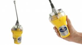
#EPIRB - Marine Notice No 9 of 2017 contains a product advisory for two EPIRB products manufactured by McMurdo.
Under certain circumstances, signs of cracking may appear in the top dome cases of all versions of the McMurdo SmartFind EPIRB and the Kannad Marine EPIRB Sport, Sport Pro and Sport Pro + models.
This cracking area is outside of the waterproof seal and as such does not compromise the integrity of any affected unit.
McMurdo recommends that any such unit “should be subject to rectification work at the earliest opportunity” and provides support details for any in-warranty units in the Marine Notice, available to read or download HERE.
Marine Notice: Training Course Statutory Certification In Ireland
#MarineNotice - Marine Notice No 6 of 2017 from the Department of Transport, Tourism and Sport (DTTAS) advises that anyone undertaking maritime training in Ireland should ensure that any course leading to certification is approved by and complies with the statutory certification issued by the competent authority.
The Minister for Transport, Tourism and Sport is the competent authority for the approval of statutory maritime training in Ireland under both EU and Irish law. The Marine Survey Office of the DTTAS carries out this function on behalf of the minister.
Specifically, IMO STCW courses (including short courses) carried out in Ireland may only be approved by the Minister for Transport, Tourism and Sport. Candidates for seafarer and fisher certification should be aware that the DTTAS will only accept certificates issued by training providers approved by the competent authority for training carried out in Ireland.
EU mutual recognition applies to certificates issued in other EU/EEA states for training approved by and carried out under the conditions set down by the competent authorities in those member states.
Ship owners, fishing vessel owners and those employing seafarers and fishers should ensure that crew whose training was carried out in Ireland hold appropriate certification issued under the authority of the Minister for Transport, Tourism and Sport.
A holder of a certificate that is not valid, and who is serving on a vessel, may adversely affect the certification of that vessel. Such vessels, on inspection, may be subject to enforcement action for non-compliance with statutory requirements.
The DTTAS publishes a full list of approved training providers on the new Seafarers web portal.


.")


 will be going head-to-head with long-lost multi-club-representing sister Two Farr at Howth’s three-day Wave Regatta, starting Friday")


 with his best mate, getting into battle mood in the North African desert during World War II of 1939-45. Anyone who gets along well with a Jack Russell terrier, while looking so very like superstar actor Liam Neeson before Neeson was born, must have had some redeeming features - even if he was a danger to all when partying in a new kitchen")

