Menu

Ireland's sailing, boating & maritime magazine

Inland afloat headers


Displaying items by tag: Achill Island

The past weekend’s good weather tempted a group of jet-skiers who subsequently ran into difficulty in Clew Bay, as The Irish Times reports.

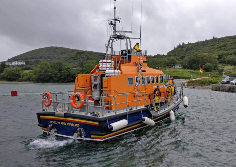
Achill Island RNLI launched its lifeboat on Saturday evening (25 April) to reports of three men on personal water craft needing assistance between Newport in Rosmoney — waters considered treacherous for even the most experienced of mariners.

All three were towed to Rosmoney with a locally owned RIB in an operation that also involed the Irish Coast Guard and An Garda Síochána.

Gardai also mounted further patrols of Lough Derg, where earlier this month they had exercised their emergency powers to warn inland waterways users to stay at home as measures to control coronavirus remain in place.

The Irish Times has more on the story HERE.

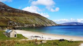
Keem Bay on Achill Island has made the grade among the 50 best beaches in the world, according to a top travel website.

And as The Irish Post reports, the Co Mayo coastal beauty spot was ranked among the best even of that number, placing just outside the top 10 of Big 7 Travel’s selection.

Keeping company with the gorgeous turquoise waters of the Adriatic and eastern Mediterranean, the West Indies and other breathtaking tropical paradises, we think that’s good going for the Wild Atlantic Way.

Published in Coastal Notes

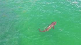
One of the world’s largest sharks had become a regular visitor to an Achill Island beach, as Independent.ie reports.

Local tourist officials have recorded almost daily sightings of the 20-plus-foot basking shark in the waters of Keem Bay over the last month.

And has word of got out, visitor numbers on the Co Mayo island are growing among those hoping to get a glimpse of the gargantuan fish.

The second biggest fish in the seas behind the whale shark — and the largest in the North Atlantic — basking sharks are regulars in Irish waters.

Indeed, number of the gentle marine wildlife giants have reached such figures that experts have referred to the waters off the West Coast in the summer months as a ‘shark ark’.

Independent.ie has more on the story HERE.

Published in Sharks

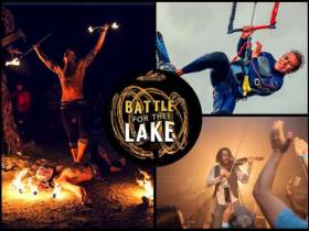
#Kitesurfing - Independent.ie has the lowdown on this weekend’s Battle for the Lake kitesurfing extravaganza on Achill Island.

Keel Lough is the venue for the finale of the 2018 IKSA tour that will see many of the same competitors that wowed the crowds during the Battle for the Bay on Dollymount Strand this past summer.

Also bringing his skills to this eighth Battle for the Lake is Kevin Langeree, Red Bull’s King of the Air, who will be giving demonstrations on the lough and even DJing for fans after dark.

Indeed its the festival atmosphere around the competition that’s as much of a draw to Mayo from today (Friday 28 September), with a packed music and comedy lineup — even fire dancers to light up the nights.

Independent.ie has more on the story HERE.

Published in Kitesurfing

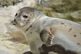
#MarineWildlife - Islanders’ attempts to rescue a seal pup stranded on Achill in Co Mayo recently were sadly not successful.

But the incident has galvanised a local group set up amid growing concerns over marine wildlife strandings, who will train with a team from Seal Rescue Ireland in January on potential lifesaving measures, as the Mayo News reports.

“We’re getting these trainers down just so people know what to do in these situations,” said Achill resident Sorsha Kennedy. “It’s okay for them to be on the shore, they may just be resting, but people don’t know that.”

Kennedy was part of a group that attempted to rescue a baby seal washed up on rocks at Keel Beach in late November.

The pup unfortunately died in transit to Seal Rescue Ireland’s base across the country in Courtown.

“It’s a terribly long stressful journey for an animal already in distress,“ said John Nikolai, who discovered the seal while walking his dog. “It’s such a pity there isn’t another sanctuary closer in the west.”

The Mayo News has more on the story, while Afloat.ie reported recently on other seal rescue efforts around the Irish coast.

Published in Marine Wildlife

The Michael Davitt Bridge that connects Achill Island to the mainland was officially opened by leading Irish land reformer Michael Davitt on 31st August 1887, making 2017 its 130th anniversary. Construction began on a replacement Michael Davitt Bridge in 1948, and was completed a year later writes Daria Blackwell

The third Michael Davitt Bridge, which was commissioned in 2008, was a design based on a Spanish Calatrava architectural model. This swing bridge weighs 390 tons, yet it is operated manually. It’s illuminated by LED lighting integrated into the bridge design, and in the long winter nights of West Mayo, this adds to its sense of permanence.

fleet departs8
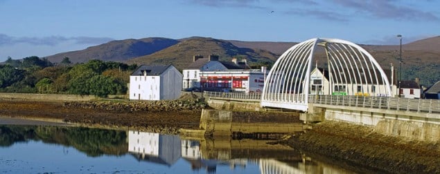
The Michael Davitt bridge at Achill Sound has an air of permanence about it, but that small central span can be opened, albeit with difficulty

And the fact is, the 2008 bridge has been rarely opened since it was built. It had been too difficult to close, so it was decided that it would be better not to open it in the first place. The sheltered theoretically-available through-transit by boats with a high air-draft via narrow and tidal Achill Sound, while not actively discouraged, was certainly not promoted as a passage-making option.

This caused a dilemma for the islanders, for when it comes to Government grant aid, an island is not an “island” if connected by a fixed bridge. A long battle with the State has been ongoing since, with the Achill islanders demanding that the bridge be shown to be openable again, and this finally happened this past weekend.

fleet departs8
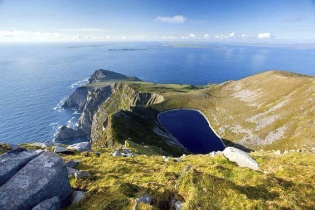
Achill Island is big country, a challenging island to sail round

To mark the connection choices that Achill maintains with the mainland, a Maritime and Heritage Festival celebrating the past and present of the Achill Parish was held on Sunday the 3rd of September. As part of the festival, the bridge was scheduled to open at 5:00 pm to allow a parade of ships to pass through at high water.

Mayo Sailing Club was invited to take part. Members of the Club accepted the invitation and seized the opportunity to go one step further and circumnavigate Achill Island. Wallace Clark had written about it in Sailing Round Ireland and several members of MSC were inspired to attempt the challenge, as it had not been done in recent memory.

fleet departs8
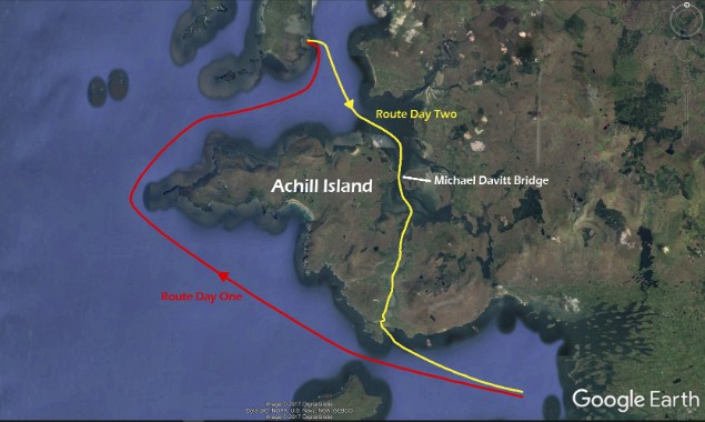
The route taken by the Mayo Sailing Club fleet at the weekend

The currents in Achill Sound run strong and swift, and shoaling is common. Mayo Sailing Club Vice Commodore Duncan Sclare organized yachts to sail from Rosmoney in a clockwise manner so they’d have a rising tide coming south through Achill Sound and still have enough water to exit the Sound beyond Corraun back into Clew Bay to return to their moorings in Rosmoney.

Navigational calculations were meticulously plotted, tides accounted for, fishermen consulted, and charts checked, as the fleet prepared to set off on the Saturday from Rosmoney. Five yachts set off on the circumnavigation. This was no small feat, as conditions on Saturday were demanding. A rough, wet and boisterous rounding of notorious Achill Head was in store for the fleet, which was subjected to 40+ knots of gusts of wind tearing down Slievemor, the second highest peak on Achill Island at 671 metres. They sought shelter for the night and holed up securely at anchor in Blacksod Bay, where good company and cold beer went down well in the pub.

fleet departs8The Mayo SC fleet safely through the bridge despite the fog, and already on their way south as the tide is ebbing. Photo: Alex Blackwell

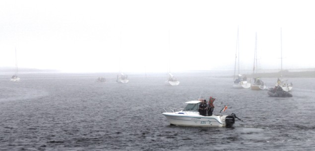
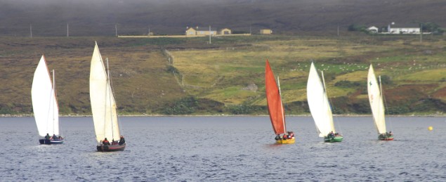
They set off in the morning to arrive at the bridge just before its scheduled opening, but a thick fog enveloped Achill and Achilbeg. Yet the project continued, even though two deeper draft vessels ran aground on the way in and had to await the incoming tide to continue on. When the time came, all five of the Achill circumnavigators succeeded in passing though the bridge, dressed for the occasion. A sixth member joined the fleet, passing under the bridge from the south and returning with the fleet, accompanied by Coast Guard vessels, rowers, and ribs, and a flotilla of the famous traditional Achill yawls making spectacular transits under sail.

fleet departs8
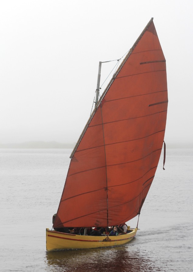
Last boat through – an Achill yawl sweeps towards the narrow gap at good speed with the sluicing tide under her…... Photo: Alex Blackwell

fleet departs8
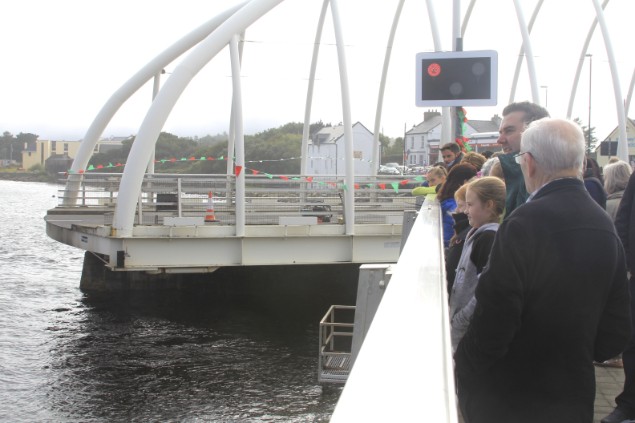
…..and almost immediately the bridge closes again………Photo: Alex Blackwell

fleet departs8
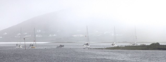
....with the MSC fleet still in fog as they disappear down the Sound………..Photo: Alex Blackwell

fleet departs8…..but back at the reinstated bridge, the sun is out, and shore transport becomes dominant once more. Photo: Alex Blackwell The crowd cheered from the bridge as each vessel passed through, and the Achill yawls then had a race in the Sound close south of the bridge in front of Alice’s Restaurant, complete with loudspeaker commentary as the evening weather finally improved for the fog to lift, and let sunshine illuminate the spectacular landscape. The day’s events were recorded by Henry McGlade for the TV show “The Irish at Home and Abroad” for an episode due to be shown on Sky TV in early October.

fleet departs8The evening sunshine strengthens as the fog continues to lift, and yawl racing gets under way in the Sound. Photo: Alex Blackwell

fleet departs8
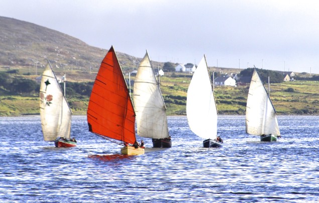
Achill yawl racing at its best – this is going to be a cracker of a finish. Photo: Alex Blackwell

But by the time the weather improved, Mayo SC fleet were well on their way, their movements dictated by the now rapidly falling tide, and it wasn’t until they were out on Clew Bay itself that the visibility began to clear properly for them, and the familiar sight of the peak of Croagh Patrick showed above the fog’s grey blanket.

Back in Mayo SC’s hospitable clubhouse at Rosmoney, Former MSC Commodore Rory Casey of the First 31.7 As Lathair commented: "One of the best sailing weekends I've ever had - we had a bit of everything. Why do we have to travel to the ends of the world, when we have this adventure sailing here on our doorstep?"

fleet departs8
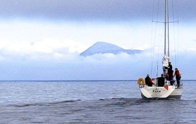
Out on the open waters of Clew Bay, it took longer for the fog to lift, but the MSC fleet got the reassuring sight of Croagh Patrick above the fog blanket as they headed for home after a successful weekend circumnavigation of Achill Island. Photo: Rory Casey
Vice Commodore Duncan Sclare, who made the circuit on one of the smaller boats, the Achilles 30 Freebird, summed it up: "On this circumnavigation of Ireland’s largest island, we experienced it all: Flat calm, Atlantic seas, howling winds, rain, sunshine, fog, tricky navigation, an unopenable bridge that opened, and great company. A voyage that will be remembered a lifetime."

The Mayo Sailing Club boats whose crews now cherish very special memories of the first weekend of September 2017 in proving that Achill is indisputably an island were: Freebird, As Lathair, Xena, Misty, Enya, and Eabha Marie.

Published in Island News

#CoastalNotes - A beach on Achill Island lost to storms 33 years ago has returned after a freak Easter tide.

And locals at Dooagh are celebrating the return of their 300-metre sandy strand that in more recent years has been bare rock, as the Guardian reports.

It’s believed a wintry cold snap in mid April, with winds from the north, led to the surprise sandy deposit — one that’s already boosted tourism in the area, part of the Wild Atlantic Way coastal route.

The Guardian has more on the story HERE.
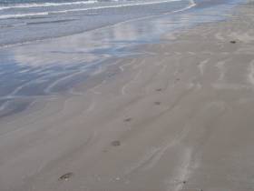
Published in Coastal Notes

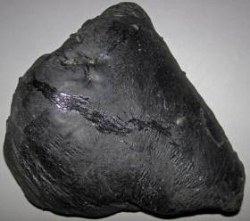
#CoastalNotes - Achill Island has been blemished by ‘tar balls’ that washed up on its Blue-Flagged Keel Beach during the week, as The Irish Times reports.

Appearing as black stones from a distance, the blobs of crude oil are soft and extremely sticky to the touch.

But despite being the result of oil leaks at sea, such tar balls are considered relatively harmless, according to the Irish Coast Guard.

The news comes less than a month after Fingal County Council warned of palm oil ‘fatbergs’ washed up on a Skerries beach.

Similar fatty deposits were found on beaches in Mayo last November.

Published in Coastal Notes

#RNLI - A coast-to-coast cycle starting in England and finishing in Co Mayo next month will raise funds for Achill Island RNLI.

Jane McNeela and Ursula Murray from Preston will undertake the Coast to Coast Bicycle Ride as part of the RNLI’s Mayday fundraising campaign.

The duo will leave Preston in Lancashire on Saturday 9 May and will spend the next five days cycling westbound across Ireland and deep into Mayo.

Friends for 13 years, the cyclists share a love for adventure and the great outdoors. Their previous endeavours include climbing the highest three peaks in the UK, fire walking and cycling from London to Paris.

But their latest endeavour has a personal twist, as McNeela is already familiar with the West of Ireland, having family connections in the Mayo town of Ballycroy.

The programme begins with a 120-mile cycle from Preston to Holyhead in Wales on Saturday 9 May and then, after a ferry trip to Dublin Port, another cycle to their hotel in Dublin.

On the Sunday they will cycle to Mullingar, while on the Monday they will move on to Strokestown and from there onwards to Swinford on Tuesday. On Wednesday they will cycle to Tiernaur. On Thursday, they will take on the final leg of the journey when they cycle to Achill Island’s bridge before finishing up at Achill Island’s lifeboat station in Kildavnet.

Plans are afoot for a group of cyclists to support the duo on their final trip from Tiernaur to Achill on Thursday 14 May.

Following their mammoth trek, a presentation night will be held in Patten’s Lounge Bar in Derreens, Achill on Friday 15 May to show the RNLI’s appreciation for the efforts of the women and their supportive husbands, Mark and Greg.

Speaking ahead of their adventure, McNeela said: "We decided to take on this challenge for Achill Island RNLI because of an incident in the sea in Achill when my 13-year-old daughter got into difficulties because of a strong current.

"Though panic set in, prompt action by her friend saved the day before we needed to call on the RNLI but it made me realise how invaluable the lifesaving charity it is and it was reassuring to know that there was a lifeboat station in Achill if we had needed to make the call that day."

Anthony McNamara, chair of Achill Island RNLI's fundraising branch, said all at the station were "delighted that Jane and Ursula have chosen Achill Island RNLI to benefit from their coast-to-coast bicycle ride and we would encourage cyclists to join them in their final leg or offer support at any of the places they will stop in on their way to Achill.

"Our lifeboat crew relies on the generosity of the public to help them to continue to save lives at sea. From crew kit to training and fuel for our lifeboats, every penny and cent raised by this cycle will help us to continue to rescue people every day."

Published in RNLI Lifeboats

#IslandNews - A glass-floored viewing platform jutting out over the Atlantic Ocean on Achill Island has got officials excited about its potential to attract tourism.

But locals are concerned that the project could mar the area's special views with an eyesore.

As the Mayo News reported last month, funding has been secured to develop the so-called 'Signature Discovery Point' at Keem Beach on Ireland's largest coastal island.

Keem Beach is one of 35 locations along the Wild Atlantic Way in Co Mayo that will share in the €257 million funding pot.

And the ambitious plans for the area – that also features as part of the new Galway-Mayo Blueway – include a viewing platform over the waves and rocky shore near the old coastguard station, along the lines of the Grand Canyon Skywalk.

But the reaction among the Achill community has been mixed, with support for the initiative by development company Comhlacht Forbartha Áitiúil Acla tempered by comments from local sculptor Ronan Halpin, who expressed concerns over the "visual intrusion" and "sustainability" of such a unique engineering project.

“Keem Bay is one the most beautiful and unspoilt places in our country. Its isolation and seclusion are a major part of its inherent charm," he added. "The proposal to build a glass walkway at the top of Moiteóg would seem to fly in the face of all this natural beauty and majesty."

The Mayo News has much more on the story HERE.

Published in Island News
Page 4 of 6

General Information on using Waterways Ireland inland navigations

Safety on the Water

All users of the navigations are strongly recommended to make themselves aware of safety on the water for whatever activity they are involved in and to read the advice offered by the various governing bodies and by:

The Dept. of Transport, Ireland: www.gov.ie/transport and The Maritime and Coastguard Agency, UK, The RNLI – Water Safety Ireland for information in terms of drowning prevention and water safety.

Registration of Vessels

All vessels using the Shannon Navigation, which includes the Shannon-Erne Waterways and the Erne System must be registered with Waterways Ireland. Only open undecked boats with an engine of 15 horsepower or less on the Shannon Navigation, and vessels of 10 horsepower or less on the Erne System, are exempt. Registration is free of charge.

Craft registration should be completed online at: https://www.waterwaysireland.org/online-services/craft-registration

Permits for use of the Grand and Royal Canals and the Barrow Navigation

All vessels using the Grand and Royal Canals and the Barrow Navigation must display appropriate valid Permit(s) i.e A Combined Mooring and Passage Permit (€126) and if not intending to move every five days, an Extended Mooring Permit (€152).

Permit applications should be completed online at: https://www.waterwaysireland.org/online-services/canal-permits

Passage on the Royal and Grand Canals – Dublin Area

For boat passage through the locks east of Lock 12 into / out of Dublin on either the Royal or Grand Canals, Masters are requested to contact the Waterways Ireland Eastern Regional Office (M-F 9.30am-4.30pm) on tel: +353(0)1 868 0148 or email [email protected] prior to making passage in order to plan the necessary lock-keeping assistance arrangements.

On the Grand Canal a minimum of two days notice prior to the planned passage should be given, masters should note that with the exception of pre-arranged events, a maximum of 2 boats per day will be taken through the locks, travelling either east or west.

Movements in or out of the city will be organised by prior arrangement to take place as a single movement in one day. Boaters will be facilitated to travel the system if their passage is considered to be safe by Waterways Ireland and they have the valid permit(s) for mooring and passage.

Newcomen Lifting Bridge

On the Royal Canal two weeks’ notice of bridge passage (Newcomen Lifting Bridge) is required for the pre-set lift date, and lock assistance will then also be arranged. A minimum of 2 boats is required for a bridge lift to go ahead.

Waterways Ireland Eastern Regional Office (Tel: +353(0)1 868 0148 or [email protected] ) is the point of contact for the bridge lift.

A maximum number of boats passing will be implemented to keep to the times given above for the planned lifts (16 for the Sat / Sun lifts & 8 for the weekday lifts). Priority will be given on a first come first served basis.

On day of lift, boaters and passengers must follow guidance from Waterways Ireland staff about sequence of passage under bridge & through Lock 1, and must remain within signed and designated areas.

Events Held on the Waterways

All organised events taking place on the waterways must have the prior approval of Waterways Ireland. This is a twelve week process and application forms must be accompanied with the appropriate insurance, signed indemnity and risk assessment. The application should be completed on the Waterways Ireland events page at :

https://www.waterwaysireland.org/online-services/event-approval

Time Limits on Mooring in Public Harbours

On the Shannon Navigation and the Shannon-Erne Waterway craft may berth in public harbours for five consecutive days or a total of seven days in any one month.

On the Erne System, revised Bye Laws state that: No master or owner shall permit a vessel, boat or any floating or sunken object to remain moored at or in the vicinity of any public mooring, including mooring at any other public mooring within 3 kilometres of that location, for more than 3 consecutive days and shall not moor at that same mooring or any other public mooring within 3 kilometres of that location within the following 3 consecutive days without prior permission by an authorised official.

Winter Mooring on the Shannon Navigation and Shannon Erne Waterway

Winter mooring may be availed of by owners during the period 1 Nov to 31 Mar by prior arrangement and payment of a charge of €63.50 per craft. Craft not availing of Winter Mooring must continue to comply with the “5 Day Rule”. Winter Mooring applications should be completed online at : https://www.waterwaysireland.org/online-services/winter-moorings-booking

Owners should be aware that electricity supply and water supply to public moorings is disconnected for the winter months. This is to protect against frost damage, to reduce running costs and to minimise maintenance requirements during the winter months.

Vessel owners are advised that advance purchasing of electricity on the power bollards leading up to the disconnection date should be minimal. Electricity credit existing on the bollards will not be recoverable after the winter decommissioning date. Both services will be reinstated prior to the commencement of the next boating season.

Smart Cards

Waterways Ireland smart cards are used to operate locks on the Shannon Erne Waterway, to access the service blocks, to use the pump-outs along the navigations, to avail of electrical power at Waterways Ireland jetties.

Berthing in Public Harbours

Masters are reminded of the following:

  • Equip their vessel with mooring lines of appropriate length and strength and only secure their craft to mooring bollards and cleats provided for this purpose.
  • Ensure the available berth is suitable to the length of your vessel, do not overhang the mooring especially on finger moorings on floating pontoon moorings.
  • Ensure mooring lines, electric cables and fresh water hoses do not create a trip hazard on public jetties for others users.
  • Carry sufficient fenders to prevent damage to your own vessel, other vessels and WI property.
  • Allow sufficient space between your vessel and the vessel ahead /astern (c.1m) for fire safety purposes and /or to recover somebody from the water.
  • Do not berth more than two vessels side by side and ensure there is safe access/egress at all times between vessels and onto the harbour itself.
  • Do not berth in such a way to prevent use of harbour safety ladders, slipways or pump-outs.
  • Do not allow the bow of your vessel to overhang the walkway of a floating mooring thus creating a hazard for others with an overhanging anchor or bow fendering.
  • Animals are not allowed to be loose or stray at any time.
  • Harbour and jetty infrastructure such as railings, power pedestals, fresh water taps, electric light poles, safety bollards, ladders etc are not designed for the purpose of mooring craft , they will not bear the strain of a vessel and will be damaged.
  • At Carrybridge on the Erne System, Masters of vessels are not permitted to use stern on mooring. Masters of vessels must use the mooring fingers for mooring of vessels and for embarkation / disembarkation from vessels.

Passenger Vessel Berths

Masters of vessels should not berth on passenger vessel berths where it is indicated that an arrival is imminent. Passenger vessels plying the navigations generally only occupy the berths to embark and disembark passengers and rarely remain on the berths for extended periods or overnight.

Lock Lead-in Jetties

Lead-in jetties adjacent to the upstream and downstream gates at lock chambers are solely for the purpose of craft waiting to use the lock and should not be used for long term berthing.

Vessel Wake

Vessel wake, that is, the wave generated by the passage of the boat through the water, can sometimes be large, powerful and destructive depending on the hull shape and engine power of the vessel. This wake can be detrimental to other users of the navigation when it strikes their craft or inundates the shoreline or riverbank. Masters are requested to frequently look behind and check the effect of their wake / wash particularly when passing moored vessels, on entering harbours and approaching jetties and to be aware of people pursuing other activities such as fishing on the riverbank.

Speed Restriction

A vessel or boat shall not be navigated on the Shannon Navigation at a speed in excess of 5 kph when within 200 metres of a bridge, quay, jetty or wharf, when in a harbour or canal or when passing within 100 metres of a moored vessel or boat.

Vessels navigating the Shannon-Erne Waterway should observe the general 5 kph speed limit which applies along the waterway. This is necessary in order to prevent damage to the banks caused by excessive wash from vessels.

Vessels navigating the Erne System should observe the statutory 5kt / 6mph / 10kph speed limit areas.

A craft on the Royal and Grand canals shall not be navigated at a speed in excess of 6km per hour.

A craft on the Barrow Navigation shall not be navigated at a speed in excess of 11km per hour except as necessary for safe navigation in conditions of fast flow.

Bank Erosion

Narrow sections of all the navigations are particularly prone to bank erosion due to the large wash generated by some craft. Masters are requested to be vigilant and to slow down to a speed sufficient to maintain steerage when they observe the wash of their craft inundating the river banks.

Unusual Waterborne Activity

Unusual waterborne vessels may be encountered from time to time, such as, hovercraft or amphibious aircraft / seaplanes. Masters of such craft are reminded to apply the normal “Rule of the Road” when they meet conventional craft on the water and to allow extra room to manoeuvre in the interest of safety.

Sailing Activity

Mariners will encounter large numbers of sailing dinghies from late June to August in the vicinity of Lough Derg, Lough Ree and Lower Lough Erne. Sailing courses are marked by yellow buoys to suit weather conditions on the day. Vessels should proceed at slow speed and with due caution and observe the rules of navigation when passing these fleets, as many of the participants are junior sailors under training.

Rowing

Mariners should expect to meet canoes and vessels under oars on any part of the navigations, but more so in the vicinity of Athlone, Carrick-on-Shannon, Coleraine, Enniskillen and Limerick. Masters are reminded to proceed at slow speed and especially to reduce their wash to a minimum when passing these craft as they can be easily upset and swamped due to their very low freeboard and always be prepared to give way in any given traffic situation.

Canoeing

Canoeing is an adventure sport and participants are strongly recommended to seek the advice of the sport’s governing bodies i.e Canoeing Ireland and the Canoe Association of Northern Ireland, before venturing onto the navigations.

Persons in charge of canoes are reminded of the inherent danger to these craft associated with operating close to weirs, sluice gates, locks and other infrastructure particularly when rivers are in flood and large volumes of water are moving through the navigations due to general flood conditions or very heavy localised precipitation e.g. turbulent and broken water, stopper waves. Shooting weirs is prohibited without prior permission of Waterways Ireland.

Canoeists should check with lockkeepers prior entering a lock to ensure passage is done in a safe manner. Portage is required at all unmanned locks.

Canoe Trail Network – "Blueways"

Masters of powered craft are reminded that a canoe trail network is being developed across all navigations and to expect more organised canoeing along these trails necessitating slow speed and minimum wash when encountering canoeists, rowing boats etc

Rockingham and Drummans Island Canals – Lough Key

It is expected that work on Rockingham and Drummans Island Canals on Lough Key will be completed in 2021. Access to these canals will be for non-powered craft only, eg canoes, kayaks, rowing boats.

Fast Powerboats and Personal Watercraft (Jet Skis)

Masters of Fast Powerboats (speed greater than 17kts) and Personal Watercraft (i.e.Jet Skis) are reminded of the inherent dangers associated with high speed on the water and especially in the confines of small bays and narrow sections of the navigations. Keeping a proper look-out, making early alterations to course and /or reducing speed will avoid conflict with slower vessels using the navigation. Personal Watercraft are not permitted to be used on the canals.

Towing Waterskiers, Wakeboarders, Doughnuts etc

Masters of vessels engaged in any of these activities are reminded of the manoeuvring constraints imposed upon their vessel by the tow and of the added responsibilities that they have to the person(s) being towed. These activities should be conducted in areas which are clear of conflicting traffic. It is highly recommended that a person additional to the master be carried to act as a “look-out” to keep the tow under observation at all times.

Prohibition on Swimming

Swimming in the navigable channel, particularly at bridges, is dangerous and is prohibited due to the risk of being run over by a vessel underway in the navigation.

Age Restrictions on operating of powered craft

In the Republic of Ireland, Statutory Instrument 921 of 2005 provides the legal requirements regarding the minimum age for operating of powered craft. The Statutory Instrument contains the following requirements:

- The master or owner of a personal watercraft or a fast power craft shall take all reasonable steps to ensure that a person who has not attained the age of 16 years does not operate or control the craft

- The master or owner of a pleasure craft powered by an engine with a rating of more than 5 horse power or 3.7 kilowatts shall take all reasonable steps to ensure that a person who has not attained the age of 12 years does not operate or control the craft.

Lifejackets and Personal Flotation Devices (PFDs)

Lifejackets and PFD’s are the single most important items of personal protective equipment to be used on a vessel and should be worn especially when the vessel is being manoeuvred such as entering / departing a lock, anchoring, coming alongside or departing a jetty or quayside.

In the Republic of Ireland, Statutory Instrument 921 of 2005 provides the legal requirements regarding the wearing of Personal Flotation Devices. The Statutory Instrument contains the following requirements:

- The master or owner of a pleasure craft (other than a personal watercraft) shall ensure, that there are, at all times on board the craft, sufficient suitable personal flotation devices for each person on board.

- A person on a pleasure craft (other than a personal watercraft) of less than 7 metres length overall shall wear a suitable personal flotation device while on board an open craft or while on the deck of decked craft, other than when the craft is made fast to the shore or at anchor.

- The master or owner of a pleasure craft (other than a personal watercraft) shall take all reasonable steps to ensure that a person who has not attained the age of 16 years complies with paragraph above.

- The master or owner of a pleasure craft (other than a personal watercraft), shall take all reasonable steps to ensure that a person who has not attained the age of 16 years wears a suitable personal flotation device while on board an open craft or while on the deck of a decked craft other than when it is made fast to the shore or at anchor.

- The master or owner of a pleasure craft (other than a personal watercraft) shall take all reasonable steps to ensure that a person wears a suitable personal flotation device, at all times while – (a) being towed by the craft, (b) on board a vessel or object of any kind which is being towed by the craft.

Further information is available at: http://www.irishstatutebook.ie/eli/2005/si/921/made/en/print

Firing Range Danger Area – Lough Ree

The attention of mariners is drawn to the Irish Defence Forces Firing Range situated in the vicinity of buoys No’s 2 and 3, on Lough Ree on the Shannon Navigation. This range is used regularly for live firing exercises, throughout the year, all boats and vessels should stay clear of the area marked with yellow buoys showing a yellow "X" topmark and displaying the word "Danger".

Shannon Navigation, Portumna Swing Bridge Tolls

No attempt should be made by Masters’ of vessels to pay the bridge toll while making way through the bridge opening. Payment will only be taken by the Collector from Masters when they are secured alongside the jetties north and south of the bridge.

Navigating from Killaloe to Limerick on the Shannon Navigation

The navigation from Killaloe to Limerick involves passage through Ardnacrusha locks, the associated headrace and tailrace and the Abbey River into Limerick City. Careful passage planning is required to undertake this voyage. Considerations include: lock passage at Ardnacrusha, water flow in the navigation, airdraft under bridges on Abbey River in Limerick, state of tide in Limerick

Users are advised to contact the ESB Ardnacrusha hydroelectric power station (00353 (0)87 9970131) 48 hours in advance of commencing their journey to book passage through the locks at Ardnacrusha. It is NOT advised to undertake a voyage if more than one turbine is operating (20MW), due to the increased velocity of flow in the navigation channel, which can be dangerous. To ascertain automatically in real time how many turbines are running, users can phone +353 (0)87 6477229.

For safety reasons the ESB has advised that only powered craft with a capacity in excess of 5 knots are allowed to enter Ardnacrusha Headrace and Tailrace Canals.

Passage through Sarsfield Lock should be booked on +353-87-7972998, on the day prior to travel and it should be noted also that transit is not possible two hours either side of low water.

A Hydrographic survey in 2020 of the navigation channel revealed that the approach from Shannon Bridge to Sarsfield Lock and the Dock area has silted up. Masters of vessels and water users are advised to navigate to the Lock from Shannon bridge on a rising tide one or two hours before High Tide.

Lower Bann Navigation

The attention of all users is drawn to the “Users Code for the Lower Bann”, in particular to that section covering “Flow in the River” outlining the dangers for users both on the banks and in the navigation, associated with high flow rates when the river is in spate. Canoeists should consult and carry a copy of the “Lower Bann Canoe Trail” guide issued by the Canoe Association of Northern Ireland. Users should also contact the DfI Rivers Coleraine, who is responsible for regulating the flow rates on the river, for advisory information on the flow rates to be expected on any given day.

DfI Rivers Coleraine. Tel: 0044 28 7034 2357 Email: [email protected]

Lower Bann Navigation – Newferry – No wake zone

A No Wake Zone exists on the Lower Bann Navigation at Newferry. Masters of vessels are requested to proceed at a slow speed and create no wake while passing the jetties and slipways at Newferry.

Overhead Power Lines (OHPL) and Air draft

All Masters must be aware of the dangers associated with overhead power lines, in particular sailing vessels and workboats with cranes or large air drafts. Voyage planning is a necessity in order to identify the location of overhead lines crossing the navigation.

Overhead power line heights on the River Shannon are maintained at 12.6metres (40 feet) from Normal Summer level for that section of navigation, masters of vessels with a large air draft should proceed with caution and make additional allowances when water levels are high.

If a vessel or its equipment comes into contact with an OHPL the operator should NOT attempt to move the vessel or equipment. The conductor may still be alive or re-energise automatically. Maintain a safe distance and prevent third parties from approaching due to risk of arcing. Contact the emergency services for assistance.

Anglers are also reminded that a minimum ground distance of 30 metres should be maintained from overhead power lines when using a rod and line.

Submarine Cables and Pipes

Masters of vessels are reminded not to anchor their vessels in the vicinity of submarine cables or pipes in case they foul their anchor or damage the cables or pipes. Look to the river banks for signage indicating their presence.

Water Levels - Precautions

Low Water Levels:

When water levels fall below normal summer levels masters should be aware of:

Navigation

To reduce the risk of grounding masters should navigate on or near the centreline of the channel, avoid short cutting in dog-legged channels and navigating too close to navigation markers.

Proceeding at a slow speed will also reduce “squat” effect i.e. where the vessel tends to sit lower in the water as a consequence of higher speed.

Slipways

Reduced slipway length available under the water surface and the possibility of launching trailers dropping off the end of the concrete apron.

More slipway surface susceptible to weed growth requiring care while engaged in launching boats, from slipping and sliding on the slope. Note also that launching vehicles may not be able to get sufficient traction on the slipway once the craft is launched to get up the incline.

Bank Erosion

Very dry riverbanks are more susceptible to erosion from vessel wash.

Lock Share

Maximising on the number of vessels in a lock will ensure that the total volume of water moving downstream is decreased. Lock cycles should be used for vessels travelling each way.

High Water Levels:

When water levels rise above normal summer level masters should be aware of:

Navigation

Navigation marks will have reduced height above the water level or may disappear underwater altogether making the navigable channel difficult to discern.

In narrow sections of the navigations water levels will tend to rise more quickly than in main streams and air draft at bridges will likewise be reduced.

There will also be increased flow rates particularly in the vicinity of navigation infrastructure such as bridges, weirs, locks etc where extra care in manoeuvring vessels will be required.

Harbours and Jetties

Due care is required in harbours and at slipways when levels are at or near the same level as the harbour walkways' as the edge will be difficult to discern especially in reduced light conditions. It is advised that Personal Flotation Devices be worn if tending to craft in a harbour in these conditions.

Slipways

Slipways should only be used for the purpose of launching and recovering of water craft or other objects from the water. Before using a slipway it should be examined to ensure that the surface has sufficient traction/grip for the intended purpose such as launching a craft from a trailer using a vehicle, that there is sufficient depth of water on the slipway to float the craft off the trailer before the concrete apron ends and that the wheels of the trailer do not drop off the edge of the slipway. That life-saving appliances are available in the vicinity, that the vehicle is roadworthy and capable of coping with the weight of the trailer and boat on the incline. It is recommended that slipway operations are conducted by two persons.

Caution to be Used in Reliance upon Aids to Navigation

The aids to navigation depicted on the navigation guides comprise a system of fixed and floating aids to navigation. Prudent mariners will not rely solely on any single aid to navigation, particularly a floating aid to navigation. With respect to buoys, the buoy symbol is used to indicate the approximate position of the buoy body and the ground tackle which secures it to the lake or river bed. The approximate position is used because of the practical limitations in positioning and maintaining buoys in precise geographical locations. These limitations include, but are not limited to, prevailing atmospheric and lake/river conditions, the slope of and the material making up the lake/river bed, the fact that the buoys are moored to varying lengths of chain, and the fact that the buoy body and/or ground tackle positions are not under continuous surveillance. Due to the forces of nature, the position of the buoy body can be expected to shift inside and outside the charted symbol.

Buoys and perches are also moved out of position or pulled over by those mariners who use them to moor up to instead of anchoring. To this end, mariners should always monitor their passage by relating buoy/perch positions with the published navigation guide. Furthermore, a vessel attempting to pass close by always risks collision with a yawing buoy or with the obstruction that the buoy or beacon/perch marks.

Masters of Vessels are requested to use the most up to date Navigation guides when navigating on the Inland Waterways.

Information taken from Special Marine Notice No 1 of 2023